This county, created by Act of the Legislature Dec. 22, 1857, is named for William Schley, member of Congress 1833-35 and Governor 1835-37. Ellaville is named for Ella Burton, daughter of Robert Burton, who sold the land for the town site. Nearby . . . — — Map (db m27089) HM
The Jail for Schley County was built in 1893 for $5,500. For many years the family of the Sheriff lived in the Jail and prepared meals for the inmates. This practice continued through the term of Sheriff Rigsby in 1945. The building is still in use . . . — — Map (db m174159) HM
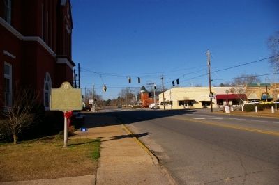
Sylvania was established as the county seat of Screven County by an Act of the General Assembly, December 24, 1847. Moses N. McCall, Willis Young, John A. Cross, John R. Kittles, Solomon Zeagler, William Lovett and John Roberts were named . . . — — Map (db m7797) HM
Martin Luther King Jr. was arrested for protesting racial segregation in Albany on December 16, 1961, and held in the Sumter County jail. Kings arrest dovetailed with community and Student Nonviolent Coordinating Committee (SNCC) efforts to . . . — — Map (db m172819) HM
Talbot County was created by Act of Dec. 14, 1827 from Muscogee County. Originally, it included part of Taylor County. It was named for Matthew Talbot (1767-1827), member of legislature, member of the Convention that framed the Constitution of Ga., . . . — — Map (db m27364) HM
Taylor County was created by Act of Jan. 15, 1852 from parts of Macon, Marion and Talbot Counties. It was named for Zachary Taylor (1784-1850), 12th President of the U.S., Major-General, Commander of the Army of the Rio Grande. Known as “Old . . . — — Map (db m27232) HM
This County, created by Act of the Legislature February 16, 1856, is named for Dr. William Terrell who died in 1855. He served in Congress from 1817 to ‘21. Eight miles west of here was fought the Battle of Echo-wa-noth-away Swamp in the Creek . . . — — Map (db m27014) HM
Elijah Hill, Jr. • Clarice A. Hobbs • Curtis Thomas William A. Morris • Reverend I.L. Mullins • Helen Clark On August 11, 1975, the Thomasville Branch of the National Association for the Advancement of Colored People (NAACP) and six . . . — — Map (db m197892) HM
Jack Woolard served in the United States Air Force from 1967 to 1971. He served as a Sergeant aboard an AC-130 Gunship in the Spectre Squadron in Vietnam from 1968 to 1969. After receiving an Honorable Discharge, he moved to Tifton. Woolard began . . . — — Map (db m197690) HM WM
Towns County was created by Act of March 6, 1856 from Rabun and Union Counties. It was named for George Washington Towns, Governor of Georgia from 1847~1851. Gov. Towns was born in Wilkes County, May 4, 1801, of a Virginia family. Self-educated, he . . . — — Map (db m37370) HM
Henry "Peg" Gilbert was a beloved deacon at Union Springs Baptist Church and a loving husband and father of four daughters. He owned 112 acres of land in Troup County and was a community advocate.
Gilbert, 42 years old , was arrested without . . . — — Map (db m194500) HM
Union County was created by Act of Dec. 3, 1832 from Cherokee. Originally, it contained part of Fannin and Towns Counties. In 1832 there was much discussion over Union and States’ rights. John Thomas, chosen by the people as a representative for the . . . — — Map (db m33498) HM
Washington County, which once embraced all the territory from the Cherokee corner North, from the Ogeechee to the Oconee and the Liberty on the South, was surveyed in 1784. Soon the small settlement known as Warthen’s Store was designated as the . . . — — Map (db m24393) HM
White County, created by Act of Dec. 22, 1857, was cut off from Habersham and Lumpkin Counties. Wm. H. Shelton, Repr. from Habersham at the session tried twice to have the county formed but failed. Repr. David T. White of Newton Co. backed the bill . . . — — Map (db m21294) HM
On December 5, 1911, the first person was hanged on the third floor gallows. The hanging occured before the jail was dedicated in January 1912. — — Map (db m25593) HM
Raised in Waikiki, Duke was a full blooded Hawaiian, who symbolized Hawai'i to millions of people. He developed into an Olympic Champion and the world's fastest swimmer. Between 1912 and 1932 he won three gold medals, two silver and a bronze in four . . . — — Map (db m73257) HM
When in 1899 organized lawlessness challenged the power of Idaho, he upheld the dignity of the state, enforced its authority and restored
law and order within its boundaries, for which he was assassinated in 1905.
“Rugged in body, . . . — — Map (db m128543) HM
New addition built 1893
Prison Commissioners
William J. McConnell, Gov.
Jas. F. Curtis, Sec. of State
Geo.M. Parsons, Atty. Gen.
Jas. King, Arch’t. — — Map (db m63000)
Built in May, 1864 by G.B. Walker at a cost of $10975. Jointly used by Idaho Territory and Boise Co. Original site was on Buena Vista Bar west of City. Building was moved in 1930 to make way for gold mining, and move twice more before being placed . . . — — Map (db m119105) HM
The year was 1885 when Cassia County purchased an unfinished hovel for its first courthouse. Idaho was still a territory - a place where disagreements were at times decided by the business end of a gun. Sparked by disputes between cattle and . . . — — Map (db m124028) HM
J.L. Davis... Diamondfield Jack... spent most of 6 years in the Cassia County jail while the courts and pardon board were trying to figure out what to do with him. By far the best known of the gunmen who fought in Idaho's sheep and cattle wars, he . . . — — Map (db m31639) HM
Original Cassia County Jail cells where Diamondfield Jack was held in Albion from March 1897 to February 1899.
The jail was moved to Oakley after the jail here burned. — — Map (db m138483) HM
Charged with hacking a prominent local merchant to pieces, five Chinese were hanged here by vigilantes Sept. 18, 1885.
They were just setting out on a long, hard 240 mile trip from Pierce to face trial at the county seat in Murray when the . . . — — Map (db m121442) HM
One summer's night in 1885, it is alleged that five Chinese men gained entrance to the Fraser General Store, while their fellow countrymen set-off fireworks up and down Main Street. It was a stormy night and the fireworks supposedly helped drive-off . . . — — Map (db m121515) HM
In 1862 Tim Goodale opened an Oregon Trail Cutoff which descended a steep ridge just west of here into the valley below.
Later that year a gold rush to Boise Basin came up Payette Valley, and the next summer farmers along the river started . . . — — Map (db m119238) HM
During a gun war that broke out between company and union miners here, several boxes of dynamite were exploded shattering a four-story mill, July 11 1892
Overwhelmed by union miners, company managers surrendered. Six fatalities -- half from . . . — — Map (db m122820) HM
The McCall City Jail was built for $650 in June, 1930, directly behind the City Hall located on the corner of Lenora and Third Streets.
The City Hall building was later moved 12 miles to Roseberry, ID, leaving the jail as a sole reminder of . . . — — Map (db m109934) HM
(Top Section)
Champaign County was always on Lincoln’s circuit. Abraham Lincoln spent nearly 20 years of his life practicing law on the 8th Judicial Circuit, traveling from one county seat to another. Even as the circuit shrank while . . . — — Map (db m24340) HM
The first Juvenile Court in the world was established in Chicago in 1899. From 1907 to 1921 it was housed in this building located across the street from Hull-House. The structure was the first to combine a juvenile court woth a detention home for . . . — — Map (db m136209) HM
In memory of
Allan Pinkerton,
born in Glascow, Scotland,
August 25th 1819.
Died in Chicago, Illinois,
July 1st 1884.
Aged 65 years.
A friend to honesty
and a foe to crime,
devoting himself for a generation to the prevention . . . — — Map (db m61986) HM
[Center tablet:]
St. Michael, heaven's glorious commissioner of police, who once so neatly and successfully cleared God's premises of all its undesirables, look with kindly and professional eye on your earthly force.
Give us cool heads, stout . . . — — Map (db m239914) HM
Police Lieutenant Herman Ziebell, 46, was shot and killed on September 30, 1946 behind a service station at the intersection of Des Plaines Avenue and Roosevelt Road when he and his partner interrupted a burglary in progress. The two . . . — — Map (db m231379) HM
Police Officer Edward Pflaume, 29, was shot and killed on December 13, 1925 as he and other officers attempted to arrest two men suspected of committing a robbery earlier in the day.
The suspects opened fire on the officers, killing . . . — — Map (db m231327) HM
Police Officer Michael Caulfield, 22, was shot and killed on September 30, 1982 inside the Forest Park police station by a suspect who had been taken into custody by detectives. The prisoner disarmed another officer and shot Officer Caulfield in the . . . — — Map (db m231336) HM
On a cold snowy morning Sergeant John Nagle and Officer Anthony Perri were killed in the line of duty while courageously engaged in a ferocious gun battle.
These brave and heroic police officers were husbands, fathers and brothers on this . . . — — Map (db m245041) HM
In recognition of River Forest police chiefs for their dedicated service.
1910 James Kunst •
1911 Thomas P. Keorin •
1912 Arthur F. Schoff •
1912 Thomas P. Kearing •
1915 Tom O. Curran •
1916 Harry C. Auspice •
1916 James . . . — — Map (db m230135) HM
Thomas Carlin, sixth elected Governor of Illinois (1838-1842), was an early settler of Illinois and a prominent figure in organizing Greene County and establishing Carrollton as its county seat in 1821.
Born in Kentucky in 1789, Carlin came to . . . — — Map (db m142746) HM
The former Mt. Vernon jail was donated to the Jefferson County Historical Society in the 1980's and was moved to the Village in 1992. The 1820 structure was originally located at 11th and Main Streets at the present Fire Department's location and . . . — — Map (db m239017) HM
Allan Pinkerton, famous detective, had his home and cooperage on this lot, 1844-1850. Here he sheltered and employed slaves escaping to freedom. After helping to capture some counterfeiters, he became deputy sheriff of Kane County in 1848. In 1850 . . . — — Map (db m55485) HM
[First plaque] Noted for its solitary confinement cells and as the locale of the only legal hanging in Knox County.
[Second plaque]
Knox County Jail
1845 – 1873
Site of the only legal
hanging in Knox County
Listed on the . . . — — Map (db m230121) HM
In 1859, Jim Gray, a slave who escaped from Missouri, was apprehended in Illinois by slave hunters. Gray was taken to Ottawa for a hearing before Justice John Dean Caton of the Illinois Supreme Court's northern division.
On October 19, with a . . . — — Map (db m201759) HM
This tablet marks the home of
John Hossáck
It was here he directed the underground
freedom of slaves 1859
Erected by
Illini Chapter D.A.R.
1947 — — Map (db m185011) HM
Top Section Photo
Lincoln’s good friend Jesse Fell had more to do with shaping early events in Livingston County and Pontiac than any other man. He named the county and, in 1837, was instrumental in having the county seat located here. . . . — — Map (db m29727) HM
Route 66 was one of the most dangerous roads in the nation, earning it the nickname “Bloody 66.” From this District 6 Headquarters building, State Police patrolled the hard road between Dwight and McLean. They enforced safety laws . . . — — Map (db m158312) HM
(front:)
Route 66, the Mother Road, is an American icon that symbolizes romance and freedom of the open road. Born in 1926, Route 66 was one of the first numbered U.S. highways, journeying 2,500 miles from Chicago to Los Angeles. Today, . . . — — Map (db m158306) HM
This building was home to state troopers who risked their lives every day patrolling Route 66.
By the 1940s, Route 66 carried more traffic than any other highway in the state. The Illinois District 6 State Police Headquarters was built . . . — — Map (db m158812) HM
The Illinois State Police was formed in 1922 to protect motorists.
Twenty officers patrolled the state on surplus World War I Harley-Davidson motorcycles. Radio-equipped cycles revolutionized communications in the 1930s. The ISP shifted . . . — — Map (db m158810) HM
In the Spring of 1876 a gang of counterfeiters plotted to steal the body of Abraham Lincoln from the Tomb in Springfield, Illinois. Hoping to be paid a ransom of $200,000.00 and the release of one of their gang, Ben Boyd, their engraver, who was in . . . — — Map (db m12319) HM
The second courthouse was an imposing structure far that time. Located on the southeast corner of Main and Main, it stood over forty feet tall, was made entirely of brick, and had a cupola for the courthouse bell. When not in use as a courthouse, . . . — — Map (db m183838) HM
(205 E. 1st South)
Built in 1869 and used for 118 years, this is one of the few Cannonball Jails still in existence. Surplus Civil War cannonballs were placed within the walls to prevent prisoner breakouts.
Route 66 garden designed and . . . — — Map (db m229839) HM
The Illinois State Penitentiary at Alton was the first institution built with public funds in Illinois. Previously, prisoners sentenced in county courts were incarcerated in crude buildings, often constructed of logs that were inadequate for the . . . — — Map (db m211622) HM
First erected in 1923 at the corner of St. Louis Street and North Main Street
Through funds raised by public donations, the clock was relocated in this Clock Tower park and presented to the City of Edwardsville in gratitude for its . . . — — Map (db m52630) HM
Site of the courthouse where, in 1824, political enemies convicted Governor Edward Coles of illegally freeing his slaves. "To preserve to a continuous line of generations that liberty obtained by the valor of our forefathers, we must make . . . — — Map (db m143182) HM
[Marker features a set of historic photos and articles:]
[Article from the Edwardsville Intelligencer titled "Glen Carbon: Thriving Mining Village, Edwardsville's Nearest Neighbor"]
Village Government 1989
Left to right: . . . — — Map (db m169613) HM
407 E. Grove St.
Lawrence and Mary Jane
Weldon House
Italianate Architectural Style, 1870
by Pennington and Coultas
A US Court of Claims judge, Weldon was a friend of
Abraham Lincoln and hosted U.S. Grant here in 1880.
The . . . — — Map (db m183805) HM
510 E. Grove St.
Ruben & Laura
Benjamin House
Built by John Routt in 1853
Italianate Architectural Style
Ruben Benjamin was examined by Abraham Lincoln
to qualify for a license to practice law.
John Routt was elected governor . . . — — Map (db m183772) HM
612 E. Grove St.
Sain & Gertrude
Welty House
Built c. 1888
Queen Anne Architecture
Only 8% of Queen Anne houses are brick and the
3 story square tower is uncommon.
Judge Welty was City Attorney from 1885 to 18(obscured) . . . — — Map (db m183747) HM
The old Engine House, City Jail and Meeting Hall were located at the corner of South Rapp and Cherry, the present site of Columbia's City Hall. It was built in 1875 at a cost of $1,075. It housed prisoners in what was commonly called, "The . . . — — Map (db m182261) HM
In the 1830's and 1840's an organized criminal gang known as the Banditti of the Prairie was active on the Midwestern frontier. In 1841 six members were arrested and held for trial in Oregon, Illinois. On March 21, the day before the trial, the . . . — — Map (db m208331) HM
200 yards north of here, a granite boulder bears this inscription "John and William Driscoll executed here June 29, 1841," These two men, father and son, were tried by 500 aroused citizens and then executed by a firing squad of one hundred eleven . . . — — Map (db m208328) HM
Nance Legins-Costley is known to history as the first enslaved person
Abraham Lincoln helped free. She was born in 1813 into indentured
servitude in Kaskaskia, Illinois Territory, to slaves Randol and Annachy
Legins. In 1827 in Springfield, . . . — — Map (db m239256) HM
Here was located the home of Samuel Elder, cofounder of Elder-Redo now called Eldorado. Judge of the county court 1849-1856, school commissioner, collector, Internal Revenue, Justice of the Peace, and farmer. He and his son, William, together with . . . — — Map (db m146459) HM
Blair was a Scottish American who arrived in St. Clair County in the 1790s and became the county sheriff. Soon after 1800 he moved to a 200-acre farm in the Clinton Hill Precinct. On March 10, 1814 he concluded negotiations with a county commission . . . — — Map (db m152951) HM
John Jacob Hays was born in New York circa 1770. His family emigrated to North America from the Netherlands in 1720. The Hays family belongs to Congregation Shearith Israel, the oldest Jewish Congregation in the United States.
John Jacob . . . — — Map (db m202482) HM
Near this site was the City Hall, police department and fire station. On the night of the massacre, more than 1,000 people sought safety in the municipal buildings. — — Map (db m142338) HM
Otto Nelson lived here, the only African American detective on the police force. His home was destroyed and he fled to St. Louis. — — Map (db m142239) HM
One of American history's most violent race riots took place here on July 2, 1917. Hundreds of citizens were brutalized in a day of death, burning, and destruction. White rioters lynched, shot, and burned innocent blacks, burned their homes, and . . . — — Map (db m228260) HM
Joseph Smith Trial Site of the third Warren County Courthouse (1837-95) where on June 9, 1841, the Mormon prophet Joseph Smith stood trial under Judge Stephen A. Douglas to determine whether he should be extradited to Missouri to face criminal . . . — — Map (db m229752) HM
This property
has been placed on the
National Register
of Historic Places
By the United States
Department of the Interior
Wyatt Earp
Birthplace
March 19, 1848
— — Map (db m55445) HM
Wyatt Berry Stapp Earp, famous for the 1881 gunfight at the O.K. Corral in Tombstone, Arizona Territory, was born on March 19, 1848, in Monmouth. According to family history, his birthplace is located at 406 South 3rd Street. When Earp was two, his . . . — — Map (db m55448) HM
Juliet/Joliet's first fire and
police by-laws and rules
were made in the
village's first adopted
charter in 1837. The first
volunteer fire department
was started at this site. — — Map (db m157487) HM
John D. Paige moved to Joliet in 1857 and quickly became established as an inventor and pioneer in the bottling of carbonated, flavored water, the precursor of today's soda pop. J.D. Paige soon expanded his business pursuits, becoming one of . . . — — Map (db m158457) HM
The first county jail was built in the Southwest Corner of the Courthouse Square and was used until 1868. It was built of double hewn logs: two rooms up, two below at a cost of $325.00. The court house could wait, but the jail had to be built. The . . . — — Map (db m211620) HM
The first election was held in 1833 at the Jeremiah Roe home. Samuel Rugg was appointed Justice of the Peace, David McKnight was appointed first Sheriff. The first County Election was held June 23, 1836.
The officials were: . . . — — Map (db m211668) HM
Increased crime during the Great Depression demanded an expanded police presence and faster communication technology. In response, the Motor Vehicle Police (established in 1921) was reorganized as the Indiana State Police in 1933. The new division . . . — — Map (db m238483) HM
Justice Sherman Minton was born in Georgetown and attended New Albany High School. After graduating from law school, he served overseas during WWI. In 1934, he was elected to the U.S. Senate as a New Deal Democrat. Nominated by President Roosevelt, . . . — — Map (db m207055) HM
Blooming Grove Vol. Fire Dept. • Brookville Vol. Fire Dept. • Cedar Grove Vol. Fire Dept. • Drewersburg Vol. Fire Dept. • Laurel Vol. Vol. Fire Dept. • Metamora Vol. Fire Dept. • New Trenton Vol. Fire Dept. • Oldenburg Vol. Fire Dept.
Killed . . . — — Map (db m229181) HM
Gibson County was formed in 1813 from the southwestern portion of the Indiana Territory. Once the wheels of county government began turning, the push to locate a county seat was imminent. The settlement of Patoka had been selected for the seat, but . . . — — Map (db m190591) HM
By the early 1900s, Indianapolis was home to multiple medical education institutions which required corpses for dissection-based learning. Extant laws failed to provide enough bodies for this use, generating a lucrative black market. In 1902, . . . — — Map (db m210940) HM
Born in Virginia, George Boxley, first settler in Adams Township, Hamilton County, came to Indiana, as a fugitive from justice. Accused of helping slaves to escape and fomenting a slave rebellion in 1816 in Spotsylvania County, Virginia, Boxley . . . — — Map (db m216521) HM
Union General in the Civil War; U.S. District Judge; Postmaster General under President Arthur; Interim U.S. Secretary of Treasury in 1884; U.S. Secretary of State under President Cleveland. Was born in Lanesville in 1832, and lived in Corydon for . . . — — Map (db m207057) HM
Harlan Carter • Martin Gregg • John Robbins
Hendricks County Commissioners
Renovated 1996
Brandt Construction Company
J.D. Clampitt • Hursel Disney • Richard Myers
Hendricks County Commissioners . . . — — Map (db m232174) HM
In the early 1950s, Kokomo Police Officer George "Al" Berryman would bring his family here, where a restaurant called "Chet's Friendly Spot" stood. But everything changed for the family on Thanksgiving evening, November 26, 1953. Officer Berryman . . . — — Map (db m231785) HM
On March 20, 2016, Howard County Sheriff Deputy Carl Koontz gave the ultimate sacrifice protecting our community. While serving an early morning search warrant in Russiaville, Indiana, the suspect opened fire on several officers. As a result, Deputy . . . — — Map (db m200751) HM
After the Civil War the Reno brothers returned home to Rockford, IN with a number of thieves and questionable characters. Soon the gang's far reaching crime sprees included train robbery, theft and murder. On the night of October 6, 1866, gang . . . — — Map (db m146503)
Killed in the line of duty December 30, 1930 Forgotten valor Frank J. Knoebel gave his life for the City of Madison in 1930. Already mortally wounded from two bullets to the abdomen by a felon trying to escape custody, Frank’s actions in . . . — — Map (db m181495) HM
born in Cannonsburg, PA, came to Indiana in 1819; elected Clerk of the Indiana House of Representatives in 1820; chosen first Judge of the New Purchase in 1822; first Judge to hold court in Indianapolis; held first court in Johnson County at John . . . — — Map (db m221852) HM
2014 entries matched your criteria. Entries 401 through 500 are listed above. ⊲ Previous 100 — Next 100 ⊳