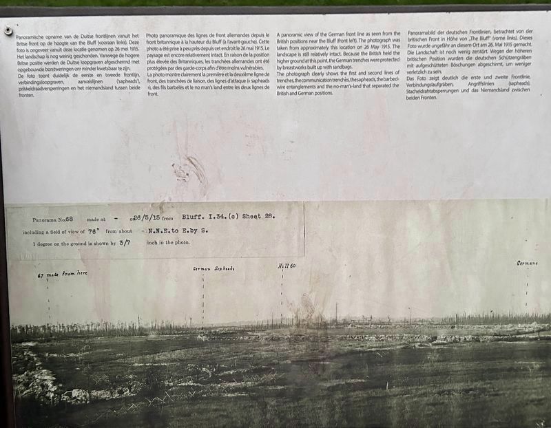
Panoramische opname van de Duitse frontlijnen vanuit het Britse front op de hoogte van the Bluff (vooraan links). Deze foto is ongeveer vanuit deze locatie genomen op 26 mei 1915. Het landschap is nog weinig geschonden. Vanwege de hogere . . . — — Map (db m266363) HM
From a line 250 metres west of this
point, 29 officers and 519 other
ranks of 1/10th (Scottish)
Battalion The King's (Liverpool)
Regiment, TF, advanced east up the slope towards German trenches on Bellewaarde ridge
4 officers and 75 other . . . — — Map (db m261342) HM WM
Here at Mount Sorrel
and on the line from
Hooge to St. Eloi the
Canadian Corps fought
in the defence of Ypres
April - August 1916 Français
Ici, au Mont Sorrel et sur la ligne de Hooge à Saint-Eloi le Le Corps canadien a . . . — — Map (db m261507) HM WM
The hedges in this part of the park are not here by accident. They mark the position of the buildings of the former Augustinian abbey, expanded over the 17th and 18th centuries. Monks lived there until the French Revolution. After that, the . . . — — Map (db m265212) HM
American temporary house, 1922
The Piets family built this American temporary house in 1922 in nearby Wevelgem It is made of pine, which is not very durable. Nevertheless Father Joseph Piets lived in it until 1978. In 2013, by then a . . . — — Map (db m267727) HM
Australian Silhouette
From the last weeks of September 1917 onwards, during the Third Battle of Ypres (Passchendaele Campaign), Australian troops - as part of the Australian and New Zealand Army Corps (ANZAC) - played a major role. They were . . . — — Map (db m266618) WM
In memory of
the officers and men
of the
Bedfordshire Regiment
1914-1918
Let those that come after
see that their names
are not forgotten. — — Map (db m266989) WM
Vroege ontwerpen van 'Buttes New British Cemetery' verwijzen naar de Australische 'Rising Sun'. Dit wordt niet uitgevoerd maar vanaf 2013 worden stroken bos gekapt. Een symbolische Rising Sun verschijnt alsnog in de top van de Polygone. . . . — — Map (db m266590) WM
Communication trench,
1914-1915
On the German side, the draining of trenches and strutting with planks and posts started early. As a result, the German trenches were initially the best developed. A lot of effort went into finishing them with . . . — — Map (db m267615) HM
Verbindingsloopgraaf, 1916-1917
Dit type wordt toegepast in natte grond. De bovenste stutten verlichten de druk op loopgraafwanden en kunnen als camouflage met groen of planken en aarde worden bedekt.
Onder de loopplanken verzekert . . . — — Map (db m267655) HM
Verbindingsloopgraaf, 1916-1917
Duitsland beschikt tegen 1917 over steeds minder metaal en het uit de tropen afkomstige jute. Daarom zie je in dit type
verbindingsloopgraaf, dat onder meer in Bayernwald bij Wijtschate werd . . . — — Map (db m267716) HM
Verbindingsloopgraaf
Anders dan Duitsland heeft het Brits imperium geen gebrek aan grondstoffen.
Verzinkte golfplaten en jute worden daarom veelvuldig toegepast. Prefab vlonderpaden ('duckboards') en A-frames, stevige . . . — — Map (db m267720) HM
To the officers, non-commissioned
officers, and men of the
Fifth Australian Division
who fought in France and Belgium
1916 - 1917 - 1918
Fromelles · Bapaume · Beaumet · Doignies · Louverval ·
Bullecourt · 3rd Battle of Ypres · Polygon . . . — — Map (db m267966) WM
Gevechtsloopgraaf, 1915-1917
Een gevechtsloopgraaf heeft een grillige vorm. Zo wordt de impact van inslaande projectielen beperkt en zijn observatie en mitrailleurposten verborgen.
Typisch is het opstapje om over de borstwering of . . . — — Map (db m267621) HM
Fire trench
Like the communication trench, this trench uses A-frames, but they have been shortened at the parapet so as not to obstruct the step. Note the niches built into the high trench walls between the jute bags. Loose hand . . . — — Map (db m267723) HM
De Nonnebossen verwijzen naar een Benedictinessenabdij die hier gevestigd was van 1101 tot 1579 en waarbij het zuidelijke deel door de Britten aangeduid is als Glencorse Wood.
De omgeving is vooral bekend als eindpunt van de Eerste Slag . . . — — Map (db m266109) HM
In memory of all ranks of the King’s Own Yorkshire Light Infantry and to the memory of all those who served in the Great War 1914-1918.
Ter nagedachtenis aan alle rangen van de King’s Own Yorkshire Light Infantry en ter nagedachtenis aan . . . — — Map (db m266986) WM
Land van de Dood
In 1917 is het kasteeldomein van Zonnebeke een oord van dood en vernieling. Wat ooit een oase van rust was, ontaardt door ongezien oorlogsgeweld in de hel op aarde.
Op 26 september 1917 bereiken geallieerden het . . . — — Map (db m266736) HM
[Each vertical strip listed separately, from left to right, in English, Dutch, French, then German]
This reconstructed trench system is based on original plans and archaeological finds. The first part is German, the second part British. . . . — — Map (db m267765) HM
Mortar post, 1915-1916
This depot is a reconstruction of an archaeological find near Pilkem. The concrete blocks are from the same excavation. The structure probably served as a storage facility for mortars, small pieces of artillery that . . . — — Map (db m267657) HM
The construction of hundreds of kilometres of narrow-gauge railway behind the front lines was a direct result of trench warfare. Such railways w[e]re essential for the transport of ammunition, troops, the wounded and millions of tons of . . . — — Map (db m267728) HM
In de winter van 1917 en het voorjaar van 1918 bezette de Nieuw-Zeelandse divisie het Polygoonbos. Ze bouwden er enkele betonconstructies. Die werden gegoten over gebogen golfplaten, 'Baby Elephants' genaamd. De randen werden afgezet door . . . — — Map (db m267010) HM
Commemorating the enduring
bonds of friendship
between Belgium and New Zealand
forged from the service of
New Zealanders at
the Battle of Broodseinde 4 October 1917,
the First Battle of Passchendaele 12 October 1917,
and Polygon Wood . . . — — Map (db m265210) HM WM
De Eerste Wereldoorlog 1914-1918 gooit het leven van mens en natuur compleet overhoop. Loopgraven, bunkers en schuilplaatsen maken de streek tot oorlogsgebied. Mijnontploffingen, artilleriebeschietingen en veldslagen verminken het landschap . . . — — Map (db m265572) HM WM
[Nederland] Het Polygoonbos is een restant van een groot woud, ooit in bezit van de abdijen van Zonnebeke en Nonnebossen. In 1914 is het eigendom van de staat. Al voor de Belgische onafhankelijkheid werd het gebruikt door militairen, . . . — — Map (db m265581) HM WM
Het Vredesbos Polygon Wood is meer dan een bos dat herinnert aan de gruwelijke gebeurtenissen van WOl. De 523 hoogstammen in het bos herinneren persoonlijk aan een gekende, gesneuvelde militair die op één van de twee begraafplaatsen van . . . — — Map (db m267217) HM WM
Polygone Ruiterpad
Het Polygone-ruiterpad (27 km) plaatst het glooiende landschap rond Zonnebeke centraal. Het gebied vormt de waterscheidingskam tussen het IJzer- en Leiebekken. Rijke akkers wisselen er af met beboste heuvelruggen. . . . — — Map (db m266741) HM
Protective wooden shelter, 1914-1915
This shelter was rebuilt based on archaeological finds at Messines. It is typical of the early stages of the war. Timber from damaged farms nearby was often used as building material. Small entrances and . . . — — Map (db m267619) HM
When Polygon Wood fell into their hands in 1916, the Germans built positions and constructions there. Scott Post was one of them. It was made pouring concrete with the aid of old wooden casing and iron reinforcement. The bunker had one . . . — — Map (db m260845) HM
Shelter "baby elephant",
1917-1918
The first British corrugated iron was used at the end of 1915. These plates were known as "elephant", possibly because the large arch is reminiscent of an elephant's back. They were easy to transport and . . . — — Map (db m267725) HM
In memory of
over 11,000 all ranks of
the Sherwood Foresters
(Nottinghamshire and Derbyshire Regiment)
who laid down their lives
on the Western Front
between 1914 and 1918.
This memorial in Derbyshire stone
has been made possible by
the . . . — — Map (db m266984) WM
Op bovenstaande foto kijk je door de kapotgeschoten muren van herberg De Polygone.
Voor de Eerste Wereldoorlog staat ze op deze hoek van het Polygoonbos. In de vroege ochtend van 11 november 1914, tijdens de Eerste Slag bij leper, vallen tussen . . . — — Map (db m265616) HM
To the 8960 men of the Regular Territorial
and Service Battalions of the Black Watch
who gave their lives in the Great War
Near this spot in November 1914
the 1st Battalion The Black Watch
(Royal Highlanders) as part of 1st Guards . . . — — Map (db m266102) HM WM
On 13 August 1914, 31 officers and 1,031 soldiers of the 1st Battalion - The Black Watch (Royal Highlanders) - embarked for France as part of the British Expeditionary Force (BEF) and took part in a series of battles and fighting withdrawals . . . — — Map (db m266103) HM
This is Beecham Farm. The occupant accidentally, discovered a deep dugout here in 1999 when the ground literally gave way beneath her. The construction was removed for safety reasons. It was closely examined and measured and largely reconstructed . . . — — Map (db m261986) HM
Je hebt het mogelijk al gemerkt: het zicht op leper ris vanaf deze plek adembenemend. Dat ontging ook de Duitsers niet. Begin 1917 bouwden ze hier bunkers waarvoor rijen prikkeldraad werden geplaatst. De Flandern I-stelling, die in . . . — — Map (db m266733) HM
Passchendaele Memorial
On 10th November 1917, the Canadian army corps captured the high ground where the village of Passchendaele had stood. This marked the close of the third battle of Ypres, the offensive launched by the British Fifth . . . — — Map (db m266717) WM
A Ses Morts
A Ses Heros
Qui En Des Jours
Desesperes En Mai 1940
Lutterent
A Passchendale
Pour Le Salut
De La Patrie
Aan Zijn Gesneuvelde
Aan Zijn Helden
Die Bij Wanhopige
Dagen In Mei 1940
Te . . . — — Map (db m266718) WM
Welkom aan de Start van de Canadian Road to Passchendaele. Met het afwandelen van deze route treed je in de voetsporen van de Canadese troepen, die in 1917 de moeilijke taak krijgen om de ruïnes van Passendale in te nemen.
De Canadezen . . . — — Map (db m266844) HM WM
The War on the Western Front 1914-1918
In the First World War the Western Front a battle line extending from
the Channel coast to Switzerland along which, for four years, millions of men fought and died - was the principal and vital theatre. . . . — — Map (db m265551) WM
De Eerste Wereldoorlog 1914-1918 gooit het leven van mens en natuur compleet overhoop. Loopgraven, bunkers en schuilplaätsen maken de streek tot oorlogsgebied. Mijnontploffingen, artilleriebeschietingen en veldslagen verminken het . . . — — Map (db m267013) HM
This is the largest Commonwealth War Graves Commission
(CWGC) cemetery in the world. It is the final resting place of
nearly 12,000 First World War servicemen, more than 8,300 of whom remain unidentified. They died in the fighting around Ypres . . . — — Map (db m267261) HM
Dit is de grootste begraafplaats van de Commonwealth War Graves Commission (CWGC) ter wereld. Bijna 12 000 soldaten uit de Eerste Wereldoorlog hebben hier hun laatste rustplaats. Meer dan 8 300 van hen werden nooit geïdentificeerd. Ze . . . — — Map (db m267262) HM
Deze Gedenkplaat Werd Onthuld
Van Het Poolsche Leger Op
1 Juli 1945
Ter Herinnering Aan 7 September 1944
Dag Der Intrede In Passchendaele Der Eerste
Poolsche Geblindeerde Divisie Vechtend
Voor Uwe Vrijheid En De Onze. . . . — — Map (db m266719) HM WM
245 entries matched your criteria. Entries 201 through 245 are listed above. ⊲ Previous 100