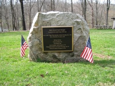
Born in this Village of New Hampton, Lebanon Township, NJ in 1736.
Died in Winchester, VA July 6, 1802.
Military Service
French and Indian War
Revolutionary War
Battle of Quebec, Canada Captured 1775
Distinguished himself in the Battle . . . — — Map (db m17920) HM
A Patriot of considerable distinction, Colonel John Haslet was the Commander of Delaware's first Continental Regiment. A native of County Londonderry, Ireland, he emigrated to America in 1757. Haslet was a graduate of the University of Glasgow, and . . . — — Map (db m5380) HM
Built for British troops in the French and Indian Wars, the Barracks housed Hessians and Loyalists when Washington attacked Trenton Dec. 26, 1776. Later, it fell into private hands . Patriotic women bought one wing in 1902. In 1914, the State bought . . . — — Map (db m208101) HM
"We entered the town with them pell-mell, and here succeeded a scene of war of which I had often conceived but never saw before. The hurry, fright, and confusion of the enemy was [not] unlike that which will be when the last trump . . . — — Map (db m127001) HM
Settled in 1679, Trenton looks back on more than 300 years of tumultuous history. Scene of the two Battles of Trenton in 1776 and 1777 and New Jersey’s State capital since 1790, Trenton embarked on the path that turned the city into a center of . . . — — Map (db m3852) HM
The colonial government authorizes the construction of the Trenton barracks to house soldiers fighting in the French and Indian War — — Map (db m211703) HM
During the French and Indian War (1754-63) British troops were initially quartered (housed) in private residences. After a wave of protests from the colonists, the Provincial Assembly in 1758 authorized the construction of barracks, for 300 men . . . — — Map (db m93944) HM
Friedrich Wilhelm August Heinrich Ferdinand Baron von Steuben was born September 17, 1730 in Magdeburg, Prussia (Germany) to a military family. Reared in the rigorous military school of Frederick the Great, von Steuben served with distinction in . . . — — Map (db m7259) HM
In 1735, Royal Governor Jonathan Belcher ordered Sussex County's Government and Courts to be moved from Log Gaol to the tavern - house of Thomas Woolverton (1717-1760). Justice of the Peace and Tax Collector, until a permanent Courthouse was erected . . . — — Map (db m27284) HM
Block House Hill - Block house during French and Indian War.
Home of Capt. Shimer - across this way.
End of Jersey City-Milford Turnpike one mile south.
Brick House built 1776 - one and one-half miles south.
Minisink Church, . . . — — Map (db m231581) HM
Bell House – has housed nine generations of same family.
Minisink Village – white men and Indians lived together.
Minisink Island – in river to the west.
Westbrook Fort – during French and Indian War in rear of barn.
Ennis . . . — — Map (db m27279) HM
Casper Shafer, a German emigrant settled this area circa 1742. By 1750, he built this stone house, later fortifying it with a stockade during the French and Indian War. His first grist mill, built 1743, was located upstream, replacing it in 1764 . . . — — Map (db m26448) HM
Wallpack Township, formed in 1731 out of Hunterdon County, included the present townships of Montague, Sandyston and the former Pahaquarry.
The Delaware River forms the western boundary and the Old Mine Road, supposedly built by Dutch miners . . . — — Map (db m49024) HM
Born in County Tyrone, Ireland in 1733.
His Scotch-Irish parents brought family here to Greenwich Township in 1747.
Never married and died in Hunterdon Co., Nov. 4, 1796 and buried in this churchyard.
Always a Soldier, from Private to . . . — — Map (db m167187) HM
Fort Frederick Governor Edmund Andros Made an Inspection in Albany in 1676 and Found Fort Orange, Located Near the Foot of Madison Avenue in Poor Condition. He Ordered a New Fort Constructed at a Site in the Center of State Street Just West of Lodge . . . — — Map (db m5248) HM
Prior to the construction of the New York State Barge Canal
and dam at Crescent, the Mohawk River was shallow and
fordable most of the year. For centuries, Native Americans
had crossed at this place. In 1755, during the French and
Indian War, a . . . — — Map (db m138984) HM
1735 - 1927
Van Schaick Mansion
Home Of
John G. Van Schaick
and his Wife Anna Patriot Americans
Built by Anthony Van Schaick
Son of Goosen Gerritsen original patentee
Headquarters
August 18-September 8-1777
Northern . . . — — Map (db m7250) HM
1755 Constructed as Military Road from
Albany to Lake George by Provincial
Troops from New York, New England
and New Jersey under command of
Major General William Johnson
———
Named in honor of Major General . . . — — Map (db m24514) HM
Once called Ireland's Corners. Named in 1871 for Gen. John Campbell, 4th Earl of Loudoun.
Commander of His Majesty's forces - French & Indian Wars — — Map (db m142982) HM
Waterways to the Interior
Rivers and lakes served as the superhighways of the 18th century. Many rivers and lakes in the Colony of New York either bordered New France (Canada), or connected the bordering water bodies to the . . . — — Map (db m201458) HM
Built by Celoron in 1749 when
he explored and claimed this
region for France. Followed an
Indian Trail and crossed the
highway at this point in 1753. — — Map (db m57155) HM
Built by Celoron in 1749 when he
explored and claimed this region for
France, followed an Indian Trail and
crossed the highway at this point.
In 1753 it was rebuilt by the French
for military purposes — — Map (db m57171) HM
This wasn't always the quiet, peaceful place you find today. Point au Fer was once an important strategic military post.
The northern half of Lake Champlain used to be controlled by the French. On June 6, 1760, during the French and Indian War . . . — — Map (db m234761) HM
In 1774, a two-story white stone garrison was built here by the British, fortified by American Gen. John Sullivan with entrenchment and stockade in 1776 and destroyed by fire in 1805. British occupation 1774 - 1775 and 1776-1796. American . . . — — Map (db m49069) HM
Near here the Frenchman
Chabert Joncaire in 1758
set up the first white
establishment on the site
of Buffalo.
Evacuated 1759 at the approach
of the British. — — Map (db m57151) HM
“The fort is of wood, built in a most masterly manner. It has five Bastions, mounts 105 guns, and has casements for 4,000 Men, and to hold provisions de Guerre et de Bouche for four months. Within the Fort are good Stone Barracks for . . . — — Map (db m11442) HM
This tablet is erected by the Society of Colonial Wars in the State of New York AD 1912 to commemorate the capture of Fort St. Frédéric and the erection of this fortress AD 1759 by the British and Provincial Army commanded by General Sir Jeffrey . . . — — Map (db m9336) HM
The most practical mode of travel and communication through the wilderness separating French Canada and British North America during the 18th century was by water. The Sorel (Richelieu) River, Lake Champlain, Wood Creek, and the Hudson River . . . — — Map (db m11434) HM
Fort St. Frédéric consisted of an outer, bastioned limestone wall enclosing the Citadel, a four-story, eight-sided tower with walls twelve feet thick at the base. Cannon were mounted on each floor of the Citadel, and entry was gained by a . . . — — Map (db m11415) HM
These barracks were constructed in the fashionable Georgian style of the day, uncommon in the northern interior of New York in the mid-18th century. The soldiers’ barracks is composed of four dwelling units of four rooms. Each doorway opens into a . . . — — Map (db m11443) HM
In 1730, the French erected a small wooden fort at Point a la Chevelure, now Chimney Point, Vermont, thereby taking control of territory claimed by Great Britain under the terms of the Treaty of Utrecht (1713). The following year, construction of . . . — — Map (db m11435) HM
The white flag was the French naval ensign. It was also the flag flown over all forts that came under the royal authority in New France from the end of the seventeenth century until the British Conquest. — — Map (db m126270) HM
Crown Point is the site of two major 18th-century fortifications: France's Fort St. Frédéric and Great Britain's fort at Crown Point. The ruins of these forts have survived substantially unchanged since the late 18th century and have been . . . — — Map (db m162026) HM
The Saint Andrews Society of Glens Falls, N.Y. erected this tablet to commemorate the heroic gallantry of the 42d Regiment of Foot better known as “The Royal Highlanders” of “The Black Watch” who on July 8, 1758 lost here in . . . — — Map (db m9561) HM
Sacred to the memory of the gallant Highlanders of the 42nd Regiment of Foot “The Black Watch” From a regiment a thousand strong 205 died and 287 were wounded July 8, 1758 assaulting the French lines on the heights of Carillon - Their . . . — — Map (db m9579) HM
In 1756 the French erected a mill on the river opposite this spot for sawing and preparing timbers used in Fort Carillon, renamed Fort Ticonderoga when captured by General Amherst in 1759.
General Abercromby used the saw mill as his headquarters . . . — — Map (db m125190) HM
British soldiers who chose not to return to England following the Seven Years War mustered out of the army to settle on land they had seen during the campaigns against the French. The sandy loam soil around Streetroad has sustained a diversity of . . . — — Map (db m19722) HM
This fertile plain was once the floor of a prehistoric sea that receded to create Lake Champlain. When the French built Fort Carillon, known to the English as Ticonderoga, these rich lowlands supported a large garden to supplement the . . . — — Map (db m126311) HM
This fertile plain was once the floor of a prehistoric sea that receded to create Lake Champlain. When the French built Fort Carillon, known to the English as Ticonderoga, these rich lowlands supported a large garden to supplement the limited . . . — — Map (db m126329) HM
Along this site in July, 1759, British forces under Amherst erected an artillery battery to attack the French Fort at Carillon, which they seized and named Fort Ticonderoga. — — Map (db m10078) HM
Major post on Lake George, a small palisaded log fort, built in 1756 to defend Fort Carillon from British attack, & named Camp De Contrecoeur, stood in this vicinity. — — Map (db m45104) HM
Chretten! Ce ne fut Point Montcalm et la Prudence ces arbres renverses, ces heros, leurs exploits qui des anglats confus ont Brish l’esperance c’est le bras de ton dieu vainqueur sur cette croix! (Montcalm A Sa Mere, 21 Juillet 1758) Here after . . . — — Map (db m138497) HM
Near this spot, July 6, 1758
Lord George Augustus Howe
was killed in a skirmish
preceding Abercrombie’s defeat
by Montcalm at Fort Carillon. — — Map (db m6141) HM
Here are interred the bones of Eighteen Colonial Soldiers found near the Old Military Road in Ticonderoga Village on Nov. 1st 1924 — — Map (db m9650) HM
Built by the French 1755-1758 General James Abercrombie defeated by the Marquis de Montcalm, July 8, 1758 Captured by Sir Jeffery Amherst July 27, 1759 and renamed Fort Ticonderoga Captured by Ethan Allen May 10, 1775 Captured by Sir John Burgoyne . . . — — Map (db m9447) HM
During the 18th century, when nations fought to control the strategic route between the St. Lawrence River in Canada and the Hudson River to the south, the fortification overlooking the outlet of Lake George into Lake Champlain was called “the . . . — — Map (db m9094) HM
Behind this enclosure are intact bake French Bake ovens built by the French army in 1757 The ovens survived the 18th century buried under ten feet of earth placed over them to make them bombproof, and were a popular destination for tourists in . . . — — Map (db m193815) HM WM
Underneath you are intact bake ovens built by the French army in 1757. The large opening here was a chute that wood could be tossed down to heat them. The French army quickly built four ovens to bake bread for the troops as they began to . . . — — Map (db m193838) HM WM
From this point south, this street follows the route of the Indian carry between the lakes and of Montcalm’s military road traversed by Washington and Franklin during the Revolution. Erected by Ticonderoga Chapter Daughters of the American . . . — — Map (db m9090) HM
Eighteenth century soldiers lived largely on portable food. On the march, their diet consisted of flour, rice, dried peas and beans, salted or pickled meat – goods that could travel in bags or barrels without spoiling. In Europe, soldiers . . . — — Map (db m126326) HM
To commemorate the heroic gallantry and noble character of George Augustus Viscount Howe Brigadier-General of His Majesty’s Forces in America. Killed near Trout Brook two days before the great battle of Carillon July 6, 1758. His death an . . . — — Map (db m9562) HM
This tablet marks the landing for the grand carry on the Great War Trail between the Indian tribes of the north and south country. It also marks the beginning of that carry between the lakes to avoid the falls and rapids, which later became the . . . — — Map (db m16309) HM
The tides of history have swept repeatedly through this valley, following the river
that drains Lake George into Lake Champlain, 220 feet below. When forests covered the land, people traveled by water, so this short link between the 33 miles of . . . — — Map (db m158367) HM
TiconderogaThe Lake Champlain Valley has long been at the crossroads of nations and peoples. The name Ticonderoga is a corruption of an Iroquoian word meaning a, “place between two waters,” an acknowledgement of its location which . . . — — Map (db m126401) HM
Through this pass to Trout Brook ran an Indian Trail, used by Robert Rogers after Battle on Snowshoes, 1758, on retreat to Fort Wm. Henry — — Map (db m9533) HM
Battling French & Indians and on retreat from Snowshoe Battle in 1758, Rogers' Rangers crossed over this mountain where Rogers staged his legendary escape at Rogers Rock on Lake George. — — Map (db m45765) HM
For hastening to set a crown of freedom on this new land we lie possessed of praise that grows not old. And here were men coequal with their fate who did great things unconscious they were great. Back of Monument: Champlain – Iroquois . . . — — Map (db m15593) HM
On October 3rd, 1889, a workman digging a trench opened by mere accident across the street from this point, a grave which contained the skeleton of a man, and within this grave found, at its head, a stone, now in the Black Watch Library in this . . . — — Map (db m9539) HM
Magasin du Roi, 1756
Mars Education Center, 2008
In May of 1756, French troops began work on two structures flanking the fort's place d'armes, or parade ground. Limestone quarried from the site of the fort was used for stone blocks and burned in . . . — — Map (db m193814) HM WM
In 1758 British officers and engineers examined Ticonderoga's defenses from low on Mount Defiance prior to the July 8th Battle of Carillon. During the battle, Mohawk, Delaware, and Choctaw warriors allied to the British army, positioned themselves . . . — — Map (db m193735) HM
Near this spot stood Louis-Joseph de Gozon Marquis de Montcalm on the 8th of July 1758. With a small force of French troops and Canadian volunteers, he prevented the capture of Fort Carillon by defeating a much superior British and Colonial army . . . — — Map (db m9573) HM
Robert Rogers and 74 of his Rangers in Jan. 1757 in this vicinity fought superior French forces for several hours and successfully escaped. — — Map (db m9537) HM
Ambushed by superior French
forces, Robert Rogers and
74 rangers fought near this
site on Jan. 21, 1757. All
but 14 rangers survived. — — Map (db m200377) HM
Marker #1: Two historic waterways converge at Ticonderoga. Long before the region became important to European powers, Native Americans made a portage here for carrying canoes and gear between Lake George and Lake Champlain. The five-mile-long . . . — — Map (db m19882) HM
In the mid-18th century, this battlefield was a focal point in the Seven Years’ War, a world war between France and Great Britain. Here the two super-powers struggled for control of the Lake Champlain Lake George water highway, the strategic . . . — — Map (db m9590) HM
The earthen walls in front of you, called the French Lines, are the remains of a defensive wall built in the eighteenth century to defend Fort Ticonderoga from attack. The French Lines as you see them today are the original un-restored remains of . . . — — Map (db m126143) HM
1776 1929 Through this entrance to the place D’Armes of the fort have passed George Washington, Ethan Allen, Benjamin Franklin, Seth Warner, Benedict Arnold, Major Robert Rogers, Horatio Gates, The Marquis de Montcalm, . . . — — Map (db m9449) HM
In tribute to the heroism of the troops under the unfortunate Maj. Gen’l. James Abercromby in the attack on the French lines, July 8th, 1758, to mark the capture of Fort Carillon by Lieut. Gen’l. Sir Jeffrey Amherst July 27th, 1759 and, to record . . . — — Map (db m9585) HM
Sent to the Province of New York in 1737, by his uncle Sir Peter Warren for the purpose of supervising landed property in the Mohawk Valley, William Johnson engaged in trade with settlers and Indians.
Prospering in mercantile enterprises, he . . . — — Map (db m52124) HM
Hostilities of the Seven Years' War having commenced, Colonel William Johnson was commissioned a Major General of Provincial Forces and assigned to command the Crown Point Expedition against the French, in 1755. After the failure of the other . . . — — Map (db m52121) HM
Grave of Sir William Johnson
Baronet
1715 - MASON - 1774
His Indian name
Warraghiyagey
"he who does much business"
Founder of
Johnstown
St. John's Episcopal Church
St. Patrick's Lodge 4 F.&A.M.
First Free School
Supt. of Indian . . . — — Map (db m54281) HM
A man of strong character. A colossal pioneer. One of the greatest men of his time. Sole superintendent and faithful friend of the Six Nations and their Allies. Their Warragiyaey. Founder of Johnstown. He established here the first free school in . . . — — Map (db m57754) HM
Johnson Hall
A man of Sir William’s position required a grand home to impress his many guests who arrived for political, financial, and diplomatic discussions. Commitments in the French and Indian War(1754-63), however, kept him from . . . — — Map (db m136523) HM
Graves of Captain Gershom Woodworth, French and Indian and Revolutionary Wars and Sergeant Selah Woodworth of Revolution: Mayfield Pioneer. — — Map (db m68208) HM
Genesee County's only known French & Indian War veteran
Pioneer of Stone Church
Died 1811 age 72 buried in Fort Hill Cemetery Le Roy — — Map (db m57317) HM
Ft. Hendrick
1754-1760
British post guarding
Mohawk Castle. Named for
King Hendrick killed
at Lake George, Sept. 1755
N.Y. State
Historical
Marker — — Map (db m57269) HM
Featured Text on Marker:
Peace following the French and Indian War (1756-1763) provided security on the frontier, and in 1764, Nicholas Herkimer constructed the Georgian style mansion you see here. The house remained in the Herkimer . . . — — Map (db m75328) HM
Fort Herkimer
Stood 86 rods west of this church.
It served as a place of refuge
for the pioneers
from attacks by the French and Indians,
and during the War of the Revolution,
with this church,
as a place of defense
and a . . . — — Map (db m57328) HM
Destination Montreal In 1759, the British plan for defeating the French in North America involved major expeditions that would cut off French supply routes up and down the St. Lawrence River, block French advances south through the Champlain . . . — — Map (db m90216) HM
Bivouac For two days, July 2nd and 3rd, 1759, a force of 3,000 soldiers under the command of Brigidier General John Prideaux camped here. The army was advancing along the lake on a campaign from Oswego to Four Mile Creek, near Fort Niagara. . . . — — Map (db m90266) HM
Empires in America After Christopher Columbus discovered America in 1492, European invaders claimed it for themselves. By the middle of the eighteenth century, France, England, and Spain claimed possession of most of the North American . . . — — Map (db m131876) HM
The majestic Mohawk Valley has been the scene of many key events which have helped to shape the character and destiny of New York State and the nation. This was once the home of the proud Mohawks, one of the main tribes of the powerful six-nation . . . — — Map (db m130806) HM