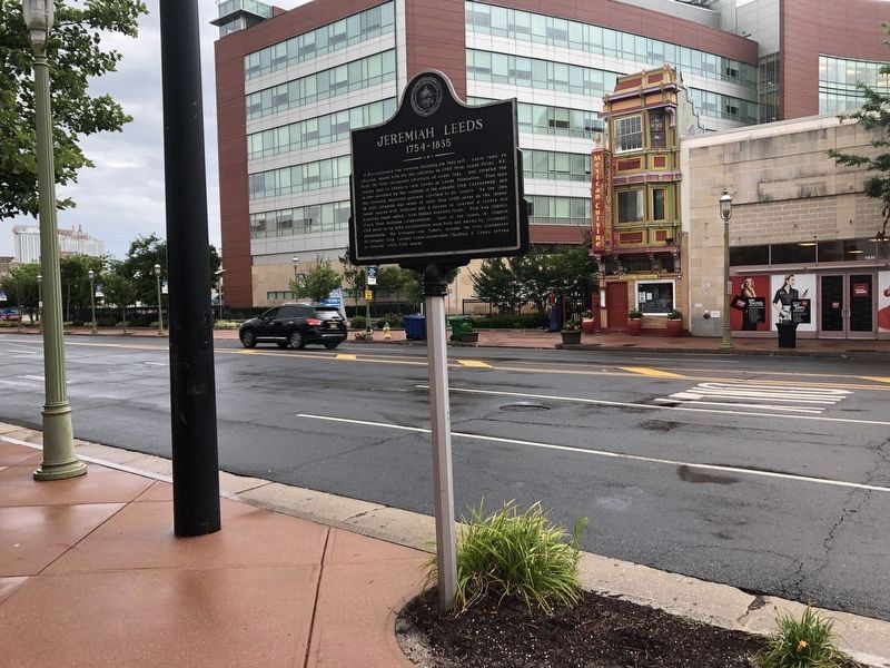
A Revolutionary War veteran standing six feet tall. Leeds came to Absecon
Island with his ten children in 1785 from Leeds Point, N.J. and built the first
permanent structure of cedar logs. He cleared the nearby land to create his
farm known as . . . — — Map (db m92434) HM
Seeking shelter from a storm, Rev. John James, a circuit riding preacher ordained by the Church in England, but disciplined in the beliefs of the Methodist Church of John Wesley, met by chance with local resident David Sayres on a cold, wintry night . . . — — Map (db m92377) HM
Living at the Forks in 1764, he became an ardent patriot and as a First Major, served in Colonel Richard Somers’ 3rd Regiment, Gloucester County Militia in 1775. He served at Mt. Holly in a skirmish in Dec. 1776 and was wounded at Trenton Jan. 2, . . . — — Map (db m64267) HM
In honor of the men of the 3rd Battalion Gloucester County Militia Col. Richard Somers – Commanding Killed in Action Pvt. Forrest Bellangy (Killed at Trenton #2) Pvt. John Cain (Murdered while POW in Tuckerton) Lt. John Lucas (Killed in . . . — — Map (db m76164) HM
In honor of the Brave Patriots of the Revolutionary War who defended their liberties and their homes in a battle fought near this site October 6, 1778 ---------- Dedicated October 6, 1911 Lower Plaque: Erected by the State of New Jersey . . . — — Map (db m10811) HM
This anchor, believed to be from a British Merchant ship captured by Privateers and sunk during the Battle of Chestnut Neck, October 6, 1778 Has been donated to the Col. Richard Somers Chapter, New Jersey Society, Sons of the American Revolution by . . . — — Map (db m76165) HM
Clark's Mills Meeting House, built by Thomas Clark about 1762, where preached the Rev. John Brainerd, stood on site of Clark Burying Ground. Thomas Clark, builder of the church, Thomas, Adrial, and Parker Clark, Revolutionary soldiers, are buried . . . — — Map (db m40582) HM
In honor of the “Privateers” who sailed and fought for American Independence “1776 – 1783” “Captains” “Ships” Samuel Allen John Badcock Rainbow John . . . — — Map (db m40339) HM
Built by Micajah Smith about 1800. Named "Methodist Union Chapel at Blackman's Mills" when incorporated in 1837. Micajah Smith, John Van Sant, privateer captains, and Jonas Morse and James Bell, Revolutionary soldiers, are buried in the Church Yard. — — Map (db m40587) HM
The first settlement in what is now known as Atlantic County was made at Chestnut Neck, on the west bank of the Mullica River, near where the village of Port Republic is now located. In 1637, John Mullica sailed up the river that took his name, . . . — — Map (db m76179) HM
And his immediate family, Grandson of John Somers, First settler, 1693, member of 3rd Regiment, Gloucester County militia. Monument erected 1850 in memory of his son, Master Commandant Richard Somers, U.S.N. 1778-1804. Site restored 1981. — — Map (db m92407) HM WM
Born at this site on September 15, 1778, educated in Philadelphia, Somers led the Battle of Tripoli and sacrificed his life on September 4, 1804. He is memorialized by both a monument at the U.S. Naval Academy and a U.S. Navy ship commissioned in . . . — — Map (db m92406) HM
At Lower Closter Dock – on the riverfront just south of here – a British invasion force of 5,000 troops commanded by Lord Cornwallis landed before dawn on November 20, 1776. Guided by three Bergen County residents, they climbed the . . . — — Map (db m144530) HM
Laid out in 1761 by New York over an earlier route when that province claimed jurisdiction over this area. Used by troops during the Revolutionary War, the road led from Closter to Closter Dock on the Hudson where farm produce was shipped to New . . . — — Map (db m7208) HM
Cornwallis Headquarters Nov. 18th 1776 Restored with the assistance of the New Jersey State Federation of Women’s Clubs by the Palisades Interstate Park Commission • 1933 • — — Map (db m116946) HM
Lower Closter or New DockHere a British invasion force of 5,000 troops commanded by Lord Cornwallis landed before dawn on November 20, 1776. Guided by three Bergen County residents, Joseph Hawkins, Isaac Perkins, and John Aldington, they climbed . . . — — Map (db m142465) HM
On 20 November 1776 British general Charles Cornwallis led 5,000 men across the Hudson and up a primitive farm road in the Palisades to begin the march south to capture the American fortifications at Fort Lee (A on the map, lower right). Word . . . — — Map (db m47508) HM
Organized in 1723 as the Schraalenburg Dutch Reformed Church. First church erected in 1728, 150 feet to the east, the present building in 1799. The True Reformed Church was founded here in 1822. The church became Presbyterian in 1913. John Henry . . . — — Map (db m7506) HM
Built about 1745 on land purchased in 1710 by Barent and Resolvert Nagel. The frame wing was added later. Owned by Barent’s son John by 1754 and later by grandson David Naugle, a militiaman during the Revolutionary War. In about 1784 David built a . . . — — Map (db m7910) HM
He saw the redcoats on the eastern hills. This Closterman who galloped through the mist to warn the troops encamped down the road at Fort Lee. His plow horse carrying him to glory on the most important ride in history, the hinge on which the door . . . — — Map (db m63549) HM
The main wing of this house was built in 1808 by Benjamin P. Westervelt who served in the local militia during the Revolution. The site of this house has been continuously owned by the Westervelt family since early colonial times. General Erskine’s . . . — — Map (db m7207) HM
In 1776, a 180 acre farm here was owned by Loyalist John Ackerson. It extended from the Tenakill to the Hudson, bordered on the north by the road used by British invaders that year. Seized as enemy property, it was bought in 1784 by Militia Captain . . . — — Map (db m7212) HM
In colonial times a crude road led from here to a landing at the Hudson River. According to the reports and maps of Generals Erskine and Wayne this road was used by Cornwallis in attacking Fort Lee on November 20, 1776. On May 10, 1779 it was used . . . — — Map (db m7206) HM
“Here lies the remains of Douwe Talema, who died on the 11th day of May 1779 in his Ninetieth Year. This aged Man at his Residence near this Place was wilfully and barbarously murdered by a Party of Tories. Traitors to their country who . . . — — Map (db m63547) HM
This example of Dutch Colonial architecture was built between 1780-1790 by Derick Banta, soldier in the American Revolution, after his birthplace here was burned by Tories. Owned by the Quackenbush family from 1792, it was sold to Isaac Dixon in . . . — — Map (db m7507) HM
In grateful remembrance
of the
Citizens of Dumont
who so nobly answered their country’s call to arms to fight in the Great War for Liberty and Democracy
1917 - 1919
[A list of names follow]
Along this road Washington and his . . . — — Map (db m7512) WM
Organized in 1723 as the Schraalenburgh Reformed Dutch Church. First church was built in 1728. In 1801 the present Old North Reformed Church was built, one mile north of first site, and continues as a Reformed congregation. This sanctuary is . . . — — Map (db m7486) HM
In the time of the revolution, the road turned here and followed the brook to Peter Burdett’s ferry, the important Hudson River approach to General Nathaniel Greene’s encampment at Fort Lee, on the hill, and the connecting link with the American . . . — — Map (db m22101) HM
Built c. 1782 by Cornelius J. Van Houten as an addition to the earlier house of his father, John C. Van Houten. Located in “Slotterdam”, the farm stretched between the Passaic and Saddle Rivers and was raided during the Revolutionary . . . — — Map (db m43782) HM
An area which in colonial times included part of Emerson, Kinderkamack extended southward into part of River Edge. The name is found recorded as early as 1686. This portion became Etna in the late 19th century and Emerson in 1909. The road which . . . — — Map (db m8634) HM
Built c. 1800 by John G. Benson, a farmer, and from 1794 to 1797, a captain in the militia. This house, an example of post-Revolutionary War Dutch Colonial architecture, was built on property confiscated by New Jersey from the Reverend Garret . . . — — Map (db m7009) HM
This area named for a Liberty Pole erected here before the Revolution. The strategic junction was the scene of many American and British troop movements, including the 1776 retreat of the Continental Army from Fort Lee, and British activity in 1776 . . . — — Map (db m7012) HM
This colonial home was built in the 18th century by a Naugle. He was said to have been a paymaster in Layayette’s Light Division. The house served as a landmark on many Revolutionary War maps. It is believed that Lafayette visited here in 1824. . . . — — Map (db m63050) HM
Fortifications were protected by obstacles, such as an abatis, or other major hindrances to assaulting troops. They were easily placed before a parapet, or breastwork, wherever trees were plentiful and were used to supplement defensive rampart . . . — — Map (db m7735) HM
The word “cannon” is derived from the Latin canna, meaning tube, pipe or gun and dates back to the 13th Century. In the 1400’s, the term described a cylinder made from iron bars “soldered” together and fortified with . . . — — Map (db m7737) HM
Beneath these cliffs, Henry Hudson’s Half-Moon was welcomed by the Lenni Lenape Indians on September 3, 1609.
Nearly 167 years later, this giant Bluff Rock became a strategic stronghold in the American War for Independence as the conflict . . . — — Map (db m7707) HM
Fort Lee Road (Main Street) was the main roadway to General Washington’s Headquarters in Hackensack. Supplies and men were in constant movement on the road to re-supply Fort Washington in New York. The Continental Army began it’s “Retreat to . . . — — Map (db m7657) HM
General Washington was in Fort Lee many times during the Battle of New York. His main headquarters was in Hackensack, but had a temporary headquarters in Fort Lee near Anderson Avenue and Elizabeth Street. His main objective in Fort Lee was to . . . — — Map (db m7647) HM
General Knox was the Commander of the Continental Army Artillery. He was in charge of the placement of the artillery cannons on the palisades in Fort Lee. His main objective was to stop the British fleet from sailing up the Hudson River. He was one . . . — — Map (db m7650) HM
General Gates was commissioned a Brigadier General and was appointed Adjutant General of the Continental Army in 1775 by orders of General Washington. He was in Fort Lee with General Washington in October 1776. — — Map (db m7652) HM
Fort Lee was constructed by General Mercer on October 18, 1776 on orders from General George Washington. Originally called Fort Constitution, it was re-christened Fort Lee in honor of General Charles Lee, second in command of the Continental Army, . . . — — Map (db m7653) HM
General Greene took command of Fort Lee on September 17, 1776 from General James Iwing. At that time there were around 2,667 troops stationed in Fort Lee. The encampment was the main quartermaster post for supplying men and equipment to Fort . . . — — Map (db m7648) HM
(1) July 12 - Fort Lee’s fortifications laid out. Together with Fort Washington on the opposite bank and aided by a river barrier, the twin fortresses are intended to thwart British control of the Hudson.
(2) July 12 - General Howe’s forces . . . — — Map (db m189474) HM
This American Liberty Elm was named after “The Liberty Tree: Our Country’s first Symbol of Freedom.” On the morning of August 14, 1765, the people of Boston awakened to discover two effigies suspended from an elm tree in protest of the . . . — — Map (db m70392) HM
The military magazine derives its name from the Arabic word, “Makhazin”, meaning granary, or storehouse. Revolutionary War magazines were constructed with emphasis on fire and waterproofing, easy accessibility to the guns serviced and . . . — — Map (db m7742) HM
Mortar shells from this battery plummeted down in high soaring arcs upon the warships, tearing through the canvas sails and bursting upon the wooden deck.
This mortar battery, joined with heavy guns on both sides of the River, made running the . . . — — Map (db m7705) HM
This defensive breastwork was built on the western edge of the bluff and guarded the road from Burdette’s Ferry to the west (to the Bastion). The parapets of timber filled with soil were built upon a stone base and were sufficient height to afford . . . — — Map (db m7710) HM
Old Army Road, now called Palisade Road, was used by General Washington and his staff to reach the palisades for observing movement on the Hudson River crossings and New York. The road was also used to re-supply General Knox’s artillery positioned . . . — — Map (db m7658) HM
Palisades Interstate Park has been designated a Registered National Historic Landmark under the provisions of the Historic Sites Act of August 21, 1935 this site possesses exceptional value in commemorating and illustrating the History of the United . . . — — Map (db m7344) HM
On July 12th, 1776, the British warships Phoenix and Rose sailed beneath the unarmed Bluff Rock, later named Fort Lee. This provocative action led Congress to order General Washington “By every art and whatever expense to obstruct effectively . . . — — Map (db m7712) HM
At Fort Lee, “hutting” – the building of permanent huts – was started at General Greene’s command to:
“Fix proper places for barracks, none to be nearer the fort than 50 rods…build timber huts…boards are to be had only for the roof. The huts . . . — — Map (db m7738) HM
(Front of Monument) :
In commemoration of the Soldiers of the American Revolution - 1776 – Erected by the State of New Jersey under the auspices of the Fort Lee Revolutionary Monument Association - 1908 –
(Left of . . . — — Map (db m7348) HM
These are the times that try men’s souls. The summer soldier and the sunshine patriot will, in this crisis, shrink from the service of their country; but he that stands it now, deserves the love and thanks of man and woman. In celebration of Fort . . . — — Map (db m47538) HM
This battery was believed to be the “Barbette Battery” as its location commanded a large field of fire of the river, stretching North to South from the Chevaux-De-Frise to the Bluff Rock’s southern edge.
A Barbette Battery’s guns fired over a . . . — — Map (db m7740) HM
Author-Soldier
“Common Sense” “American Crisis”
January 10, 1776 December 19, 1776
Thomas Paine volunteered for the Continental Army. He marched to Amboy, New Jersey, located off . . . — — Map (db m7655) HM
New Jersey is known as the Crossroads of the American Revolution and this Fort Lee crossroad on Main Street represents one of the most important sites in the United States. Here, on present day Main Street, Major General Nathanael Greene led the . . . — — Map (db m70375) HM
This retreat route on Main Street in Fort Lee, N.J. enabled General George Washington’s army to escape capture from the British and prevent the end of the War for Independence. Patriot and soldier Thomas Paine wrote about his experience in Fort Lee . . . — — Map (db m70376) HM
British Lieutenant General Charles Lord Cornwallis and five thousand of his troops crossed the Hudson River and made their way to Fort Lee from Huyler’s Landing Road on November 20th, 1776. General Nathanael Greene, warned of the invasion by a . . . — — Map (db m70384) HM
The Continental Army’s retreat route ran from the bluffs of Fort Lee’s Palisades, site of the American fortifications and nearby encampment, west on Fort Lee Road (present day Main Street) and continued west through the current towns of Leonia, . . . — — Map (db m70433) HM
Originated as an Indian trail across land the Redmen called “Campgaw”. It was surveyed during the Revolutionary War by Robert Erskine, George Washington’s mapmaker, and connected settlements in the Ramapo and Saddle River Valleys. Franklin Lakes . . . — — Map (db m12395) HM
Archibald Campbell’s tavern stood here. He supplied meals to General Washington when Peter Zabriskie’s home was used as military headquarters between November 13 and November 21, 1776 during the retreat across New Jersey. The army marched down Main . . . — — Map (db m7227) HM
Dedicated to the memory of
Brigadier General Enoch Poor
by the New Jersey Society
of the Sons of the American Revolution:
Born at Andover, Mass., June 21, 1736;
Died near Hackensack, N.J., Sept. 8, 1780.
In command of a New . . . — — Map (db m6812) HM
In memory of the Honorable Brigadier Gen. Enoch Poor of the State of New Hampshire who departed this life on the 8 day of Sept. 1780 aged 44 Years.---------------Washington, Lafayette and a portion of the American army attended the burial of Gen. . . . — — Map (db m62951) HM
Earliest records of this pioneer Dutch church, dated 1686, mark it as the second oldest in New Jersey. Old stones embedded in the east wall show the initials of founding families and first settlers.
The old burying ground contains the grave of . . . — — Map (db m6820) HM
Soldiers of the Revolution are buried in this cemetery of the True Reformed Dutch Church Deeded by Robert Campbell March 8, 1833 Erected by the Bergen County Historical Society 1937 — — Map (db m7229) HM
Hackensack was a small village centered around The Green which served as a strategic point during the American Revolution.
Washington headquartered here in November 1776 while he surveyed the local roads and bridges. — — Map (db m6867) HM
Homestead of Isaac Blanch from about 1758 and site of his grist mill, both inherited in 1767 from his father, Richard Blanch, a native of England. Isaac was a Patriot official and member of the State Assembly during the Revolutionary War. He was . . . — — Map (db m7920) HM
In use for nearly two hundred years, largely by the Blauvelt family, the earliest known burial was in 1722. The cemetery contains the graves of members of other early Bergen County families, veterans of the American Revolution and slaves. Some of . . . — — Map (db m7877) HM
Frederick Wortendyke owned this land in 1723. It was once part of a large grant called the Tappan Patent. His son Jacob, who owned the homestead during the Revolutionary War, was taken captive in one of many British raids made in the area. Later . . . — — Map (db m8683) HM
Beginning as an Indian trail, it became a Colonial road through the village of Schraalenburgh, linking Teaneck with Tappan, N.Y. Surveyed and improved in 1775, it appeared on maps made during the Revolutionary War by Americans, French and British. . . . — — Map (db m7879) HM
Located in “Pascack” on land inherited from his father, Garret Durie built this house about 1767. During the Revolutionary War, the house was plundered by both American and British armies. Durie was a farmer and a blacksmith as well as . . . — — Map (db m43787) HM
About 1756 Peter Westervelt built a small house, enlarged in 1785, on land of his wife Catlyntje Haring. During the Revolutionary War the farm was raided. Later it was owned by son Henry and his son Aaron, a Freeholder and State Assemblyman. . . . — — Map (db m43786) HM
has been designated a Registered National Historic Landmark Under the provisions of the Historic Sites Act of August 21, 1935 this site possesses exceptional value in commemorating and illustrating the history of the United States U.S. . . . — — Map (db m43142) HM
The Hermitage was home to Theodosia Bartow Prevost during the Revolutionary War, when she was married to British officer James Marcus Prevost. During the war, Theodosia was left to run the farm in the middle of a heavily contested area, and through . . . — — Map (db m84827) HM
Site of the Dutch Reformed Church of the English Neighborhood Built in 1768-9 and dedicated in 1770, with Dominie Garrett Lydecker its first minister.
Used as a guardhouse and hospital at various times during the Revolution. Torn . . . — — Map (db m7335) HM
Approximately 100 yards to the west once stood Van Horne’s Grist Mill as located on Robert Erskine’s Map and mentioned in Thomas Paine’s “Crisis” paper. One detachment of the Patriot Garrison retreating from Fort Lee, left the main . . . — — Map (db m40769) HM
Immediately south was located for a period in the early days of September 1780, the encampment of the left wing of the "light" troop of the Continental Army under Marquis de Lafayette. — — Map (db m7461) HM
On November 20th 1776, General George Washington and part of the Continental Army on their march from Fort Lee to Trenton passed this way. — — Map (db m93363) HM
In the early morning of Nov. 20, 1776 after evacuating Fort Lee by order of Gen. Washington, the Continental troops under Gen. Greene came down this road on their march to Trenton. — — Map (db m7345) HM
On August 25, 1781 during the historic 600-mile march to what was the Revolutionary War’s decisive Battle of Yorktown, Gen. Rochambeau’s army was forced to ford this river because the bridge that was here was in poor shape. The bridge of . . . — — Map (db m165837) HM
Built as a gristmill about 1760 by Lambartus Laroe and sold to Thomas Boggs in 1764, it had a pair of millstones. Boggs also ran a tavern in his nearby home. Owned by David Baldwin during the Revolution, the mill ground grain for American troops. . . . — — Map (db m24991) HM
First an Indian path, then an important road during the period of colonial settlement. Washington’s army used this road in July 1777, and at many other times during the revolution. This is one of America’s oldest roads. It was an important link . . . — — Map (db m43778) HM
Originally known as Paramus Road, one of the first Colonial roads in Bergen County, frequently used by Continental and British armies in the Revolutionary War. — — Map (db m36451) HM
Native American Settlement • Colonial Settlement • Battleground in The American Revolution • 20th Century Recreation • Historic Site New Bridge Site of 11 Engagements during the American Revolution (1775 – 1783)Much more than a revolt . . . — — Map (db m186516) HM
The first "New Bridge" erected in 1745 it was a strategic crossing during the Revolution, used by Washington'a Army during the 1776 retreat. In 1888/89, the wooden span was replaced by this iron swing-bridge, now the oldest such bridge of its . . . — — Map (db m7267) HM
Built in 1739-40 by Peter P. Demarest. In 1766 he received a license from the local court to “keep a Tavern or Public House” here. The old inn witnessed many stirring events during the American Revolution.
In November 1776, Washington led his . . . — — Map (db m7225) HM
You are standing on the very spot that Washington and his men had to cross to avoid being trapped by the Hackensack River by the pursuing British. Thomas Paine penned The American Crisis as a response to a series of defeats and the . . . — — Map (db m186505) HM
Dedicated in honorable memory to Brigadier General Casimir Pulaski 1748 ----- 1779 Fought and died for American Independence by Act of Mayor and Council of the Borough of North Arlington September 18, 1955 Mayor Leonard Barnett Councilmen J. M. . . . — — Map (db m20747) HM
This Dutch Colonial house was built by Hendrick Van Allen before the Revolutionary War on a farm that consisted of over two-hundred acres. General George Washington used this house as his Headquarters on July 14-15, 1777, when he moved his troops . . . — — Map (db m12336) HM
920 entries matched your criteria. The first 100 are listed above. Next 100 ⊳