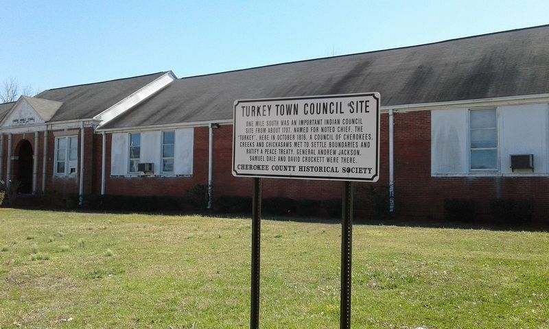
On West Main Street (Business U.S. 411) at College Street, on the left when traveling west on West Main Street. Reported missing.
One mile south was an important Indian Council site from about 1707. Named for noted chief, the "Turkey". Here in October 1816, a council of Cherokees, Creeks, and Chickasaws met to settle boundaries and ratify a peace treaty. General Andrew . . . — — Map (db m262314) HM
On 2nd Avenue North west of 5th Avenue South, on the right when traveling west.
Constructed by the Western Pipe and Steel Company of San Francisco. the Bayfield-class attack transport ship was launched on December 29, 1942, as the SS Sea Needle. The vessel was retrofitted at the Brooklyn Naval Shipyard in New York for . . . — — Map (db m224688) HM
On Alabama Route 95 0.4 miles south of County Road 48, on the left when traveling south.
The Treaty of Fort Jackson on August 9, 1814 by Major General Andrew Jackson on behalf of the President of the United States of America and the Chiefs, Deputies and Warriors of the Creek Indian Nation, established a boundary line between the . . . — — Map (db m71836) HM
On County Road 97 0.2 miles north of County Road 93, on the right when traveling north.
The Treaty of Fort Jackson on August 9, 1814 by Major General Andrew Jackson on behalf of the President of the United States of America and the Chiefs, Deputies and Warriors of the Creek Indian Nation, established a boundary line between the . . . — — Map (db m71838) HM
Near Hightower Place south of Veterans Drive ( Route 133), on the left.
Representing the Secretary of Defense at the Strategic Arms Reduction Talks in the 1980's, Michael Mobbs was a leader in negotiations between the U.S. and the U.S.S.R., resulting in the most complex arms control treaty in history. — — Map (db m219178) HM
On Montgomery Street at Molton Street, on the right when traveling east on Montgomery Street.
The Violata Pax (Wounded Peace) Dove was created in 2006 by artist Fred NALL Hollis, a native son of Alabama.
The Dove was sculpted in white bronze and came to life in a foundry in Pietrasanta, Italy. It was generously gifted to Troy University by . . . — — Map (db m224864) HM
Guarding the Flame of the Centennial Olympic Games
These heroes carried the sacred flame the
symbol of World Peace, Friendship and Unity.
Lane Barnes, William Debuty,
Charles Friedrich, Jeremy Gaertner,
Kevin Hall, Jordan Hardick,
Katie . . . — — Map (db m106095) HM
On L Street south of 9th Avenue, on the left when traveling south.
Panel 1
"Religion Gives Man Wisdom."
Martin Luther King, Jr.
[Top photo] Dr. King leads religious leaders in prayer at the Tomb of The Unknown Soldier to protest the Vietnam War, 2/6/1968 at Arlington Cemetery, Washington, D.C. . . . — — Map (db m254221) HM
On L Street south of 9th Avenue, on the left when traveling south.
With the vision of universal freedom
for all mankind
this tree is dedicated to
Spec. 4 Richard Bauer
and all
Prisoners of War
and
Missing in Action — — Map (db m254216) WM
On 3rd Street at Seward Street, on the right when traveling west on 3rd Street.
"I love this country and the ideals upon which it was founded…More than anything else, I care about the men and women who make up our military forces…I do not want to see them either kill or be killed in a war that is not moral or . . . — — Map (db m181757) HM
The United Nations' International Day of Peace is held annually on September 21 to encourage individuals, organizations, and governments to end conflict and promote peace within and among all peoples and nations. It is a global call for ceasefire . . . — — Map (db m263752) HM
Marker One:
Seven year Sister City anniversary
November 7, 1993
This Monument Symbolizes the Everlasting Bond of Friendship
Marker Two:
City of Funabashi
Ichifuna High School
Funabashi International Relation Association . . . — — Map (db m207375) HM
“The Sister City Program is an important resource to the negotiations of
governments in letting the people themselves give expression of their common desire for friendship, goodwill and cooperation for a better world for all” . . . — — Map (db m19970) HM
On South Livermore Avenue at Rodeo Lane, on the right when traveling north on South Livermore Avenue.
This cherry tree is a gift from the Consulate General of Japan in San Francisco in commemoration of the Japan-US Cherry Blossom Centennial and 35 years of friendship between Yotsukaido, Japan and Livermore. — — Map (db m198671) HM
Born in Italy, Beniamino Bufano immigrated to the United States when he was three years old, and settled in San Francisco in 1915. A popular figure of the San Francisco art scene, Bufano was well known for his signature Modern style and . . . — — Map (db m91551) HM
On Harvard Avenue North at Bonita Avenue, on the right when traveling north on Harvard Avenue North.
The Peace Pole originated in Japan 10 years
after the bombing of Hiroshima in 1945.
There are now over 250,000 Peace Poles around
the world. The Rotary Club of Claremont
is proud to be part of this tradition.
May Peace Prevail On . . . — — Map (db m305251) HM
The General Andres Pico Oak Tree once stood in Rancho San Rafael in an area that later became part of the City of Glendale. This tree played a significant role in the history of California. On January 11, 1847, representatives of Los Estados Unidos . . . — — Map (db m128302) HM
Near Bonita Drive south of Opechee Way, on the right when traveling south.
The Oak of Peace played an important role in the history of California.
It was at this site on January 11, 1847, that the surrender of the
Californios to the United States Army was arranged. Jésus Pico,
emissary of U.S. Lt. Colonel John C. . . . — — Map (db m234878) HM
This plaque was dedicated on the 50th Anniversary of the establishment of the Long Beach-Yokkaichi Sister City Association to honor the citizens of both cities who are dedicated to each through personal diplomacy. November 8, 2013
Bob . . . — — Map (db m73101) HM
On Pine Avenue at Shoreline Drive, on the left when traveling south on Pine Avenue.
In commemoration of the 10th Anniversary of the sister-city relations between Long Beach and Qingdao with the compliments of Qingdao Municipal People's Government, P.R. China — — Map (db m72459) HM
James B. Lankershim. Born Charleston, MO, March 24, 1850. Died Oct. 16, 1931. Commissioned Capt. Troop D Calvary 1st Brigade, N.G.O. Aug. 9, 1895 and Lieutenant Colonel N.G.O. July 21, 1903.
panel 2:
Near here on the bank of the Los . . . — — Map (db m125561) HM
On Astronaut Ellison S Onizuka Street at San Pedro Street, on the left when traveling north on Astronaut Ellison S Onizuka Street.
Dedicated in the memory of Dr. Morinosuke Kajima, diplomat, scholar and international businessman whose vision and generosity initiated the revitalization of Little Tokyo — — Map (db m291441) HM
On Gaffey Street south of Leavenworth Drive, on the right when traveling south.
The friendship bell, overlooking the Pacific Ocean, was presented as a gift from the people of the Republic of Korea to the people of the United States of America on the occasion of the American Bicentennial Jubilee to further the . . . — — Map (db m51064) HM
On Exposition Boulevard, on the right when traveling east.
The ultimate origin of the ancient Olympic Games is lost in the prehistoric past. In the ninth century before the Christian Era the young men of Greece were already accustomed to gather on the sacred grounds of Olympia to honor their god Zeus by . . . — — Map (db m216070) HM
On 40th Place 0.2 miles east of Central Avenue, on the left when traveling east.
First African American
to win the Nobel Peace Prize.
Built 1908. Declared 1976, Historic-Cultural Monument No. 159, City of Los Angeles, Cultural Heritage Commission, Cultural Affairs Department.
Built in 1908, this was the childhood . . . — — Map (db m174655) HM
On Lankershim Boulevard 0.1 miles north of the Hollywood Freeway (U.S. 101).
General Andrés Pico, commander of Mexican forces that
were outnumbered and militarily overpowered, agreed to
put down arms. He signed the truce with Lt. Col. John C.
Frémont, a commander of American land forces. The
Articles of Capitulation . . . — — Map (db m250249) HM
Near Lankershim Boulevard 0.1 miles north of the Hollywood Freeway (U.S. 101), on the left when traveling north.
Beneath this park rest the stone foundations and floor tiles of the historic adobe where Mexican General Andres Pico and U.S. Lieutenant Colonel John C. Fremont signed the Treaty of Cahuenga on January 13, 1847. Signing the Treaty ended the . . . — — Map (db m126025) HM
On Lankershim Boulevard 0.1 miles north of the Hollywood Freeway (U.S. 101).
Here was made the Treaty of Cahuenga by
General Andrés Pico, commanding forces for
Mexico, and Lieutenant - Colonel J. C. Frémont,
U.S. Army, for the United States. By this treaty,
agreed upon January 13th, 1847, the United States
acquired . . . — — Map (db m250254) HM
Near Lankershim Boulevard 0.1 miles north of the Hollywood Freeway (U.S. 101).
"Here was made
the Treaty of Cahuenga
by General Andres Pico
commanding forces for Mexico
and Lt.-Col. J.C. Fremont, U.S. Army
for the United States.
By this treaty, agreed upon
January 13th, 1847,
the United States acquired . . . — — Map (db m250283) HM
This plaza is dedicated in honor of an exemplary naval combat commander of WWII. The Great American victories of Midway, the Marshalls, the Philippine Sea, Iwo Jima and Okinawa are symbols of his special genius. In a similar fashion he achieved . . . — — Map (db m226350) HM
On Calle Principal near Jefferson Street, on the left when traveling north.
Larkin House, American Consulate 1844-1846. Built in 1835 by Thomas Oliver Larkin, only U.S. Consul to California.
Monterey History & Art Assn.
Courtesy Thomson J. Hudson Memorial Fund — — Map (db m33495) HM
With the vision of Universal Freedom for all Mankind this tree is dedicated to Spec 4 David Munoz and all prisoners of war and missing in action. — — Map (db m195333) WM
Near Trabuco Road 0.3 miles north of El Toro Road, on the right when traveling north.
The Angel of Hope was introduced to the world in the book, The Christmas Box, By Richard Paul Evans. It is a tale about a woman who mourns the loss of her child at the base of an
angel monument. Though mostly fictional, the angel monument once . . . — — Map (db m210733) HM
Near Avocado Avenue north of California Route 1, on the right when traveling north.
On November 27, 1984, in Newport Beach City, Mayor Evelyn R. Hart of Newport City and Mayor Shizuo Nakane of Okazaki City represented the people of the respective cities and made a Declaration of the Formation of a Sister City Affiliation. . . . — — Map (db m190048) HM
On Yorba Linda Boulevard at Eureka Avenue on Yorba Linda Boulevard.
In 1912 Frank and Hannah Nixon built this modest farmhouse on their small citrus ranch. Here Richard Nixon was born, January 9, 1913, and spent his first nine years. He served his country as Congressman, U.S. Senator, Vice President, and 37th . . . — — Map (db m50342) HM
Joining more than 200,000 locations around the world, this Palm Springs Pole brings the international initiative to this international city. Founded in 1955, the global Peace Pole Project seeks to "uplift humankind toward harmony rather than . . . — — Map (db m206210)
On Mount Rubidoux Drive near 9th Street, on the left when traveling north.
Booker Taliaferro Washington (1856-1915) was born into slavery and later became an educator, author, and orator. A passionate promoter of education, he led and expanded the Tuskegee Institute and is considered one of the most prominent African . . . — — Map (db m267319) HM
On Main Street at Mission Inn Avenue, on the left when traveling south on Main Street.
The Great Soul
In a century ravaged by war and marked by the relentless degradation of the weak, came a warrior from India unlike any the world had seen in a long time. Clad in homespun cotton (khadi) like India's poorest, and armed . . . — — Map (db m304198) HM
On Pan American Rd E, on the right when traveling north.
1915 - 1955
In Balboa Park the year 1915, San Diego opened its Panama-California Exposition. Designed to call attention to San Diego and bolster the economy, the Exposition highlighted archaeological and anthropological displays as well as . . . — — Map (db m209206) HM
On Spofford Street at Washington Street, on the left when traveling south on Spofford Street.
In the past, Spofford Alley was one of the central avenues of Chinatown. The Chee Kung Tong [Chinese Free Mason], located at 36 Spofford Alley, was the meeting place of the revolutionaries led by Dr. Sun Yat Sen, who planned the overthrow of the . . . — — Map (db m175269) HM
On Market Street at Noe Street, on the right when traveling west on Market Street.
American physician and political
radical who fought for peace, an
eight-hour workday, women's suffrage
and their right to birth control — — Map (db m187158) HM
Near Van Ness Avenue at Grove Street, on the right when traveling south.
This plaque is presented to
the City of San Francisco by the
Department of State on behalf of
the government of the United
States of America to commemorate
the use of the War Memorial Opera
House of San Francisco for all
plenary sessions . . . — — Map (db m241078) HM
On N. Center Street at E. Lindsay Street, on the left when traveling north on N. Center Street.
The Chinese community of Stockton dedicates this monument to the city of
Stockton to commemorate the bicentennial year of 1976, in memory of the
contributions which the Chinese have made to Stockton.
The ingenuity of the Chinese . . . — — Map (db m103083) HM
Sister city affiliations between the United States and other nations began shortly after World War II, and developed into a national initiative when President Dwight D. Eisenhower proposed the “people-to-people” program at a White House . . . — — Map (db m24224) HM
On El Camino Real (California Route 82) at Lincoln Street, on the right when traveling south on El Camino Real.
Here, on January 8, 1847, Francisco Sanchez, leader of a California band surrendered himself and some American prisoners and arms to Lieut. Grayson thus ending the “Battle of Santa Clara” or the “Battle of the Mustard Stalks” of January 2, 1847. . . . — — Map (db m2627) HM
On El Camino Real at Lincoln Street, on the left when traveling south on El Camino Real.
After armed confrontation nearby on January 2, 1847, and a truce meeting the following day, Marine Capt. Ward Marston, commander of the United States expeditionary force, and Francisco Sánchez, leader of the Mexican-Californian ranchers, agreed to a . . . — — Map (db m57844) HM
In memory of all those who lost their lives on September 11, 2001. 'Peace is not merely a distant goal that we seek, but a means by which we arrive at that goal' Martin Luther King Jr. — — Map (db m195467) HM
On Wynkoop Street south of 18th Street, on the left when traveling south.
This building is named for Edward W. Wynkoop (1836-1891) to honor his peacemaking efforts, though unsuccessful, to resolve the Indian-white conflict which resulted tragically in the Sand Creek Massacre in 1864.
Exaggerated reports of . . . — — Map (db m97294) HM
On Memorial Drive, on the left when traveling north.
This monument is erected in grateful memory of those Canadians who died while serving with the United States forces and those Americans who died while serving with the Canadian forces. Their sacrifice strengthens and exemplifies forever the . . . — — Map (db m251321) WM
On Trinity Street at Elm Street, on the right when traveling north on Trinity Street.
ConfuciusConfucius (551 B.C. to 479 B.C.), with the given name Qiu and stylized name Zhongni, was a native of Lu State (now Qufu city of Shandong Province) in the Spring and Autumn Period of Chinese history. He was a great thinker, educator and . . . — — Map (db m52259) HM
On Main Street (U.S. 44) at Chapel Street South, on the left when traveling north on Main Street.
To commemorate the Sister City relationship between the peoples of Hartford, Connecticut and New Ross, County Wexford in the Republic of Ireland.
This relationship promotes economic educational and cultural exchanges; and perpetually fosters . . . — — Map (db m151920) HM
On Whiting Street at Franklin Square, on the left when traveling east on Whiting Street.
Peace And
Universal
Brotherhood
[ back ]
1810 1879
To Elihu Burritt
Learned Blacksmith
Scholar Linguist Phil
anthropist to Whose
Love For Humanity
The World Owes the
First International
Peace Congress and . . . — — Map (db m41514) HM
Near Grand Street at Linwood Street, on the right when traveling west.
Zlo Dobrem Zwyciezaj
This human rights monument of common field stone and steel is built in memory of Father Jerzy Popieluszko who gave his life to God and to the goals of Solidarosc – human rights, justice, peace and freedom for Poland and . . . — — Map (db m41435) HM
Near Ingham Hill Road south of Goose Pond Road when traveling north.
Welcome to the Old Saybrook Stupa
The stupa is one of the most ancient monuments in the world. It is a Buddhist symbol of the enlightened mind and a path to its realization. It is believed to radiate peace, harmony and healing.
To receive . . . — — Map (db m260435) HM
On Whitfield Street (Connecticut Route 77) north of Boston Street ( Route 146), on the right when traveling north.
Shaumpishuh was the female chief (squaw sachem) of the Menunkatuck Indians, a small band of the Quinnipiac Tribe who conveyed their land (1639) to the English Puritans, who had arrived under the leadership of the Reverend Henry Whitfield. The . . . — — Map (db m272057) HM
On South Street (Connecticut Route 53) at Memorial Drive, on the right when traveling east on South Street.
Always Remember Never Forget
On the morning of October 23, 1983, a dump truck packed with an estimated 12,000 pounds of explosives crashed through the front gates of the U.S. Marine barracks in Beirut. The detonation ripped the four-story . . . — — Map (db m248210) WM
Near South Governor's Avenue 0.1 miles south of W North Street, on the right when traveling south.
Born in Dagsboro, Delaware, 1796. Graduate of Yale College 1815. Member of Delaware House of Representatives 1824. Secretary of State of Delaware 1826-1828. United States Senator 1829-1836, 1845-1849 and 1853 until his death, 1856. Chief Justice of . . . — — Map (db m4748) HM
On North Park Drive north of North Van Buren Street, on the right when traveling south.
"Peace" was named on the day that Berlin fell to the Allies in World War II and won the prestigious AARS Award on the day peace was signed with Japan.
"Peace" is one of the best-known and most widely grown roses of all time. Francis . . . — — Map (db m216031) HM
Near North Park Drive close to North Van Buren Street, on the left when traveling west.
Planted here in 1931, this is the same species of cherry that survives from the 1912 Japanese gift of cherry trees planted around the Tidal Basin in Washington, DC. — — Map (db m191216) HM
Near Meadow Road Northeast just west of Ellipse Road Northeast, on the right when traveling west. Reported permanently removed.
…this one would tell quite a story. It has grown as a bonsai for so long that it passed through five generations of a single family of bonsai artists in Japan before crossing the ocean to live here. The Yamaki family was well known in Japan for . . . — — Map (db m144347) HM
Near Meadow Run Northeast west of Ellipse Road Northeast, on the right when traveling west.
… this one would tell a remarkable tale. Since the 17th century, five generations of the Yamaki family tended this tree in Japan. Noted bonsai artists, the Yamakis lived in Hiroshima, where an outdoor nursery filled with priceless . . . — — Map (db m207089) HM
On T Street Northwest west of Florida Avenue Northwest, on the right when traveling west.
This hill, with its sweeping views of Washington and the Potomac, has tantalized visionaries since the 1800s. But few of their plans have been built. In 1873 businessman and city commissioner Thomas P. Morgan (whose name survives as part of . . . — — Map (db m93415) HM
On H Street Northwest at 7th Street Northwest, on the right when traveling east on H Street Northwest.
This friendship archway was erected by the District of Columbia and the Municipality of Beijing, 1986.
Marion Barry, Jr.
Mayor of Washington, D.C.
Chen Xitong
Mayor, Beijing Municipal Government — — Map (db m9161) HM
On 16th Street Northwest just north of Fuller Street Northwest, on the left when traveling south.
Built in 1922, this Beaux-Arts mansion was designed by renowned American architect George Oakley Totten, and it served as the Residence of the Ambassadors of Spain from 1927 until the late 1990s, when a new official residence was inaugurated on . . . — — Map (db m177215) HM
On Jackson Place Northwest at Pennsylvania Avenue Northwest, on the right when traveling north on Jackson Place Northwest.
700 Jackson Place has been designated a National Historic Landmark This site possesses national significance in commemorating the history of the United States of America National Park Service 1974
From 1910 to 1948 it served as the first . . . — — Map (db m32879) HM
On 15th Street Northwest at Pennsylvania Avenue Northwest, on the left when traveling north on 15th Street Northwest. Reported permanently removed.
Billions for the war,
and a bunker
for the president
The grand, pillared United States Treasury building that stands before you, its first section designed by Robert Mills in 1836, was the financial command center for the Union. It . . . — — Map (db m130407) HM
On 15th Street Northwest at G Street Northwest, on the right when traveling south on 15th Street Northwest.
Friendship between the United States and Canada was developed and strengthened by the signing of the Webster-Ashburton Treaty, on August 9, 1842, in the old State Department building which stood on this site. This treaty established the north . . . — — Map (db m17617) HM
Near Massachusetts Avenue Northwest west of 17th Street Northwest, on the right when traveling east.
Presented to the United Nations
By Jacob Blaustein
This half-size bronze of the monumental abstract sculpture, which in 1964 was placed in front of the United Nations Building in New York, symbolizes the late Secretary-General's . . . — — Map (db m112635) HM
On 23rd Street Northwest south of Sheridan Circle Northwest.
The white stone building behind the statue, purchased under Ataturk in 1936, served as the embassy of the Republic of Turkey until 1989. It is now the embassy’s official residence.
The two capitals, Ankara and Washington DC, became sister . . . — — Map (db m95948) HM
On Massachusetts Avenue Northwest just west of Scott Circle Northwest, on the right when traveling west.
Constructed according to the plans of architect Appleton Prentis Clark, Jr as the residence of Linda M. Hutchinson-Webb and family, 1913-1916, and of Daniel and Stella Stapleton, 1917-1941. Purchased by the Philippine commonwealth . . . — — Map (db m240001) HM
On 16th Street Northwest just north of S Street Northwest, on the right when traveling south.
This tower
dedicated to the ideal
of international justice
and world peace is a
loving and grateful
tribute to Owen D Young
who inspired by faith in the
constructive power of human
brotherhood contributed his
rare talents . . . — — Map (db m114772) HM
On Pennsylvania Avenue Northwest just west of 14th Street Northwest, in the median.
As American troops moved through the Meuse-Argonne, it became apparent that Germany had lost the war. An armistice was signed on November 11, 1918, effective at 11:00 a.m. — the eleventh hour of the eleventh day of the eleventh month.
In . . . — — Map (db m171289) HM
Near Virginia Avenue Northwest north of Constitution Avenue Northwest (U.S. 50), on the right when traveling west.
"Let each American nation
vie with the other in the
practice of the policy of
the good neighbor"
"Peace must be our passion"
[Back of marker:]
Cordell Hull
Secretary of State
Modelled From Life
In His 72nd . . . — — Map (db m114938) HM
On F Street Northwest just west of 18th Street Northwest, on the left when traveling east.
Given by Virginia Murray Bacon in memory of her husband, Representative Robert Low Bacon of New York, as a center to further international understanding. The building was restored for this purpose by Dacor Bacon House Foundation.
This . . . — — Map (db m212107) HM
On F Street Northwest just west of 18th Street Northwest, on the left when traveling east.
The Ringgold-Carroll House was constructed in 1825. The House had a long and close association with the U.S. Supreme Court. It later belonged to Congressman Robert Low Bacon and his wife Virginia Murray Bacon. Mrs. Bacon wanted to maintain her . . . — — Map (db m225113) HM
On 23rd Street Northwest south of D Street Northwest, on the right when traveling north.
The Department of State is the nation’s oldest and senior cabinet agency. It was established by Congress in 1789 to conduct America’s diplomatic relations.
The State Department represents U.S. interests to foreign governments, promotes peace, . . . — — Map (db m40248) HM
Near Virginia Avenue Northwest north of Constitution Avenue Northwest (U.S. 50), on the right when traveling west.
Eloy Alfaro
Presidente del Ecuador
1842-1912
Ilustre Americanista
Adalid de las Libertades
Publicas y Defensor de
los Derechos Civiles
Left side:
La Embajada del Ecuador
y la Misión . . . — — Map (db m114939) HM
On Constitution Avenue Northwest (U.S. 50) west of 17th Street Northwest, on the right when traveling west.
English:
An Inuksuk is a northern stone land marker used by the Inuit for navigation, communication and to mark hunting and fishing grounds; it symbolizes the traditional Inuit way of life.
Canada presented the Inuksuk to the . . . — — Map (db m114937) HM
On 17th Street Northwest north of Constitution Avenue Northwest (U.S. 50), on the right when traveling south.
Pan American Union
Headquarters
has been designated a
National Historic Landmark
This site possesses national significance in commemorating the history of the United States of America
Designed by renowned architect Paul Cret . . . — — Map (db m294077) HM
Near 17th Street Northwest north of Constitution Avenue Northwest (U.S. 50).
The Home
of the
Pan American Union
the international organization of the
twenty one American Republics
Erected 1908 – 1910
through the munificence of Andrew Carnegie
____________
Elihu Root
Secretary of State and
Chairman of . . . — — Map (db m66426) HM
Near International Drive Northwest south of Van Ness Street Northwest, on the right when traveling west.
The Government of Greece, on behalf of the citizens of Greece, presented to the citizens of the United States of America this bronze replica of a Classic Greek statue in a ceremony on September 17, 1965 at the United States Department of State. . . . — — Map (db m299161) HM
Near Pennsylvania Avenue Northwest (Alternate U.S. 1) east of 6th Street Northwest, on the right when traveling west.
On April 28, 1988, the Right Honourable Brian Mulroney, Prime Minister of Canada, dedicated this building to peace and friendship between Canada and the United-States .
Le 28 Avril 1988, le Très Honorable Brian Mulroney, Premier Ministre du . . . — — Map (db m59333) HM
On F Street Northwest at 3rd Street Northwest, on the right when traveling east on F Street Northwest.
Near this site on May 21, 2025, Yaron Lischinsky and Sarah Milgrim were murdered in an antisemitic attack after leaving an event at the Capital Jewish Museum.
The couple, due to be engaged, met as staffers at the Israeli embassy in . . . — — Map (db m304554) HM
On 13th Street Northwest north of Logan Circle Northwest, on the right when traveling south.
Bullomun is a gate made entirely of a single piece of granite. Translated as the gate of eternal youth, ancient Koreans believed that if you pass through the gate, you will be promised with such fortunes. This Bullomun gate was created . . . — — Map (db m284997) HM
On 13th Street Northwest north of Logan Circle Northwest, on the right when traveling south.
The Old Korean Legation building was originally built in 1877 as the residence of Seth Ledyard Phelps (1824-1885), a Civil War veteran, politician and diplomat. This building served as a diplomatic base in the United States, functioning . . . — — Map (db m284995) HM
On Klingle Road Northwest at Park Road Northwest, on the left when traveling north on Klingle Road Northwest.
Like so many emigrants before and after them, Europeans left the political and economic hardships of home for a better life in the United States. Following the 1948 communist coup in Czechoslovakia, a "Czech Row" or "Prague Road" enclave . . . — — Map (db m299162) HM
982 entries matched your criteria. The first 100 are listed above. Next 100 ⊳