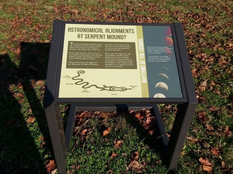
The head of Serpent Mound is lined up to the point on the western horizon where the sun sets on the Summer Solstice – the longest day of the year.
Some think the three main curves of the serpent's body point to the Summer Solstice sunrise, . . . — — Map (db m214409) HM
Serpent Mound sits within a large crater almost nine miles across. The bedrock in the center of the crater has been thrust upwards to between 400 and 900 feet above its original position, while an outer ring of bedrock has dropped from at least . . . — — Map (db m214414) HM
The UH-1 helicopier symbolized the war in Vietnam. Just the sound
of a Huey will cause any Vietnam Veteran to look skyward and
think back in time.
The frst production model Huey was put into service in 1859 and
was built by Bell . . . — — Map (db m196274) HM
The UH-1 "Huey” helicopter 1s commonly referred to as the workhorse of
the Vietnam War. It was responsible for life-saving medical evacuation,
troop and cargo movement, and when equipped as a gunship, could offer
very close and intense fire . . . — — Map (db m196277) HM WM
On March 18, 1942, four U.S. Army Air Corps pilots lost their lives within a quarter mile of this marker. Three months after Japan bombed Pearl Harbor, these pilots left Wayne County Airport near Detroit flying P-39F Airacobra pursuit planes. . . . — — Map (db m156914) HM
Sacrifice
City of Lima
public water supply
Metzger Lake
Reservoir
Constructed 1946
Capacity 1200000.000 gals
Named in memory of
Lt. William E. Metzger, Jr.
Killed in action over Germany
November 9, 1944
Awarded . . . — — Map (db m173805) WM
Susan Brownell Anthony
Woman Suffrage Leader
Visited October 19, 1878
"To secure both national and 'domestic tranquility,' to 'establish justice,' to carry out the spirit of our Constitution, put into the hands of all women....the . . . — — Map (db m53838) HM
Apollo Command Module Mock-up
The command module carried the three astronauts to the moon and back during the Apollo missions 1969-1972. The spacecraft is 10 ft. 7 in. tall and 12 ft. 10 in. diameter. It weighed 13,000 lbs.
Gemini . . . — — Map (db m237209) HM
NASA landed astronauts on the Moon and returned them safely to Earth during the Apollo Program. Moon walkers made the final leg of the journey in the Lunar Module while the Command Module Pilot continued to orbit the Moon in the Command and . . . — — Map (db m237762) HM
Learjet 28-001 Sets Five World Records
On February 19-20, 1979, Neil Armstrong set five world records in this Learjet 28-001. These record-setting events took place during flights to and from the Outer Banks of North Carolina, near the same . . . — — Map (db m237757) HM
What was the Skylancer designed to do?
A Navy Plane
The Douglas Aircraft Company originally manufactured the F5D Skylancer for the United States Navy to be an all-purpose fighter-interceptor based on an aircraft carrier. An arresting hook, . . . — — Map (db m237754) HM
This Douglas F5D Skylancer was one of four originally constructed, and is the only example still in existence. It was flown by Neil A. Armstrong from September 1960 to September 1962 to simulate the flight characteristics of the space vehicle . . . — — Map (db m237212) HM
NASA test pilot Neil Armstrong used the F5D Skylancer to create an emergency abort launch/landing procedure for NASA's Dyna-Soar program in the early 1960s. NASA used the F5D in this program because it had similar aerodynamics to the Dyna-Soar . . . — — Map (db m237755) HM
Neil was born on his grandparents' farm
southwest of town on August 5, 1930.
After living in more than a dozen communities
across Ohio, the Armstrong family settled
permanently in Wapakoneta in April 1944,
when Neil was a freshman in high . . . — — Map (db m221608) HM
First manufactured in 1977, the Learjet 28 Longhorn became the first production jet to utilize winglets in its design. This wing design increased the aircraft's operating efficiency by lowering induced drag around the wingtips. The Learjet 28 . . . — — Map (db m237756) HM
History of the Learjet Corporation
William Lear, born in Hannibal, MO, in 1902, was inspired to build a small private jet by considering a 1950s era prototype Swiss jet fighter. He founded the Learjet Corporation in Wichita, KS in 1963. . . . — — Map (db m237758) HM
Neil Armstrong and Life After Walking on the Moon
After commanding the Apollo 11 mission to the Moon in 1969, Armstrong received a job as the Deputy Associate Administrator for Aeronautics at NASA Headquarters in Washington D.C. in which he . . . — — Map (db m237759) HM
On July 20, 1969, Wapakoneta native Neil Armstrong became the first person to step onto the moon as he said the now famous line: "That's one small step for (a) man, one giant leap for mankind." Armstrong served as Commander of the Apollo 11 . . . — — Map (db m237658) HM
Stephen and Viola Armstrong moved their family, including 13-year-old Neil and his younger siblings, June and Dean, to the house at 601 West Benton Street in 1944. Here, Neil explored his fascination with flying by reading aviation magazines and . . . — — Map (db m237216) HM
In tribute to those who sacrificed their lives in the pursuit of space exploration
Challenger 1-28-1986
Francis Scobee • Michael Smith • Ronald McNair • Gregory Jarvis • Judith Resnik • Ellison Onizuka • Christa Mcauliffe
Apollo I . . . — — Map (db m237763) HM
Learjet 28-001, The Record Setter
The 28 model Longhorn, serial number 001, first flew in 1977. It received FAA certification on July 29, 1979. Neil Armstrong was serving on the Board of Directors of Gates Learjet in 1979 when he was asked . . . — — Map (db m237760) HM
On July 20, 1969, the entire world stopped and tuned in to a live tv broadcast, as Apollo 11 became the first spacecraft to land on a planetary body outside of Earth. Millions were captivated by the grainy black and white image of astronaut Neil . . . — — Map (db m237764) HM
The Gemini Program prepared NASA and its astronauts to go to the Moon. They practiced skills and maneuvers needed in orbit and reentry. The program also helped to understand the astronauts' needs for longer space travel. Two astronauts lived . . . — — Map (db m237761) HM
The Hogan Family owned and operated what was known as the Hamilton Airport for over 52 years. Airplane owner and pilot, Carl "Pop" Muhlberger and aviation enthusiast and farmer, Joe Hogan, co-founded the airport in July 1929. Muhlberger taught Joe . . . — — Map (db m225373) HM
This marker placed in remembrance of United Airlines Flight Attendant and
longtime Champaign County resident Alicia Nicole Titus, 28, who was killed when
United Flight 175 became the second airplane to crash into the World Trade
Center (South . . . — — Map (db m166195) HM WM
This marker placed in remembrance of United Airlines Flight Attendant and longtime Champaign County resident Alicia Nicole Titus, 28, who was killed when United Flight 175 became the second airplane to crash into the World Trade Center (South . . . — — Map (db m184247) HM WM
Warren G. Grimes. Raised in an Ohio orphanage, Warren G. Grimes (1898-1975) ran away after finishing the ninth grade and at age 16 went to work for the Ford Motor Company in Detroit. He later became a partner in an electrical business where . . . — — Map (db m13818) HM
Toulmin, as patent attorney for the Wright Brothers, plays a key role in one of the greatest sagas in American history. After failing to obtain the necessary patents on their own, the Wright's hire Toulmin to defend their inventions. His legal work . . . — — Map (db m13907) HM
Colonel John J. Voll from Goshen, Ohio, was
the highest scoring ace of the 15th U.S. Army
Air Force in the Mediterranean theater of World
War II. As a Captain flying a P-51 Mustang
fighter plane, he was credited with twenty-one
aerial . . . — — Map (db m204969) HM
Side A On August 9, 1968, a plane carrying 31 military passengers and crew members left the Clinton County Air Force Base for completion of an annual two-week active duty training held at Otis Air Force Base, Massachusetts. The transport . . . — — Map (db m227443) HM
Died in C-119 accident
in France [27] Oct 1972
302 TAW CCAFB
Maj. Francis R. Durkin
Lt. Col. Dale R. Anderson
Maj. Marion A. Meckstroth
T.Sgt. William L. Champion
T.Sgt. William R. Barbor — — Map (db m27968) HM
Died in C-123 accident at Ft. Sill, OK
[16] Oct 1980
302 TAW RAFB Col, OH.
Capt. George Freeland, Jr.
Maj. Thomas Brady
Lt. Col. Donald Griffith
T.Sgt. Michael Snodgrass
Sr. Amn. Robert Hass — — Map (db m143964) HM
Side A On April 18, 1964, reservists from the 302nd Troop Carrier Wing at the Clinton County Air Force Base (CCAFB) and 2nd Special Forces Group (Green Berets) of Fort Hayes, Columbus were to undergo an Operational Readiness Inspection. In . . . — — Map (db m121127) HM WM
Before and during World War II, the aviation industry was vulnerable
to adverse weather conditions, particularly thunderstorms. In 1945,
Congress mandated the nation’s first large-scale, scientific study of
thunderstorms. The Thunderstorm Project . . . — — Map (db m134868) HM
In memory of World War II Glider Pilots and support personnel at Clinton County Army Air Field 1942-45 who flight tested more than thirty United States, English and German Glider designs using various tugs while conducting hundreds of glider . . . — — Map (db m213461) HM WM
Marine Colonel Robert F. Overmyer was born July 14, 1936
in Lorain, but always considered Westlake, where his
family had lived since 1941, to be his hometown. He
graduated from Westlake High School in 1954. After earning
a bachelor’s degree in . . . — — Map (db m134308) HM
Pioneer Radio Telescope
One-half mile east is the site of the former BIG EAR radio telescope. Designed by Dr. John D. Kraus, pioneering radio astronomer at Ohio State University, it had a collecting area of 340 by 70 feet (104 by 21 meters). . . . — — Map (db m12813) HM
Dedicated in memory of those early aviation pioneers “The Early Birds.”
Between the years 1910-1917, aviators Weldone B. Cooke and Tom W. Benoist had aeroplane factories and flying schools in Sandusky which had a very important part in . . . — — Map (db m241109) HM
Weldon B. Cooke, Thomas W. Benoist, Reinhardt N. Ausmus experimented in early aviation from this site 1912 - 1917
One of Sandusky Shipyard Sites
Sail and Steamboats were built 1864-1933
Among the . . . — — Map (db m242220) HM
In memory of the ten members of crew who were lost at sea on May 11, 1964 at 3:40 am 23 nautical miles SSW (36170.06-30W) of Naval Station Rota, Spain
These ten airmen will be remembered for their sacrifice and may this memorial provide . . . — — Map (db m238536) HM WM
The original Port Columbus Airport terminal was founded by the people of Columbus and was one of the first airport facilities in the United States. Dedicated on July 8, 1929, Port Columbus was the first transfer point in the westbound . . . — — Map (db m12731) HM
Columbus was founded specifically for the purpose of being the state capital in 1812, and was selected primarily due to its location - near the center of the state. But a lack of transportation options restricted access to town. For nearly 20 . . . — — Map (db m30007) HM
America's World War I "Ace of Aces," Edward Vernon Rickenbacker was born in Columbus in 1890 to Swiss immigrant parents, leaving school at age 12 to help support his family. Working for several Columbus automobile companies initiated his love of . . . — — Map (db m173288) HM
When the U.S. entered World War I in 1917, Rickenbacker joined the Army hoping to be a part of the Air Corps. Because he was known as a race car driver and was considered too old for flight training at the age of 27, he was assigned as a driver for . . . — — Map (db m200856) HM
In the early 1900s, cars were the rage in America. While working in an auto repair garage in Columbus, Eddie took advantage of his surroundings and taught himself how to drive. By his late teens he had become a skilled automotive engineer and was . . . — — Map (db m200855) HM
RWI is a non-profit organization dedicated to improving life in the City of Columbus through projects honoring the accomplishments and spirit of Eddie Rickenbacker and Granville T. Woods. This community-based initiative, celebrating the lives and . . . — — Map (db m200852) HM
The “Tuskegee Experience,” a program of the Army Air Corps to train African Americans as military pilots, began at Tuskegee Army Air Field in Alabama in 1941. At home and abroad during World War II, the Tuskegee Airmen prevailed against enormous . . . — — Map (db m173289) HM
A primary architect of American air power, Curtis Emerson LeMay was born in Columbus in 1906, attended public schools, and graduated from The Ohio State University with a degree in civil engineering. He received his flight training through the . . . — — Map (db m12774) HM
Average Distance: 5.2 AU
Orbital Period: 11.86 years
Rotational Period: 9 hours 55 minutes
Mass (Earth = 1): 318
Diameter (Earth = 1): 11.2
Number of Moons: 79
Largest Moon: . . . — — Map (db m200990) HM
Average Distance: 1.52 AU
Orbital Period: 1.88 years
Rotational Period: 24 hours 36 minutes
Mass (Earth = 1): 0.11
Diameter (Earth = 1): 0.53
Number of Moons: 2
Largest Moon: . . . — — Map (db m200989) HM
Average Distance: 9.5 AU
Orbital Period: 29.4 years
Rotational Period: 10 hours 39 minutes
Mass (Earth = 1): 95.2
Diameter (Earth = 1): 9.45
Number of Moons: 82
Largest Moon: Titan: . . . — — Map (db m200991) HM
Average Distance: 0.72 AU
Orbital Period: 244.7 days
Rotational Period: 243 days
Mass (Earth = 1): 0.815
Diameter (Earth = 1): 0.95
Number of Moons: 0
Average Temperature: 870°F / . . . — — Map (db m200988) HM
Dedicated to those who answered the call of our country in times of strife.
Our free America lives on in peace defended by their heroism.
[Dedication marker immediately in front of memorial]:
Erected by
Howard M. Harrison Post . . . — — Map (db m12526) HM
We Gave Our All
Each man has his own reason for living and his own price for dying. We went to war for our country but in the end we fought for each other
HQ Troop
A Troop D Troop
B Troop E Troop
C Troop . . . — — Map (db m12685) HM
Born in Cleveland, Ohio. Attended Ohio State
University. Veteran of WWI. Active supporter of
OSU athletics and Columbus professional
baseball.
Casto built thousands of homes, apartment
projects and industrial/commercial buildings
throughout . . . — — Map (db m223329) HM
Born in Louisville, Kentucky - World War II Army Air Force, radiological and meteorology specialist, pacific theater - B.S. electrical engineering, Ohio State University, M.S. electrical engineering, California Institute of Technology - science . . . — — Map (db m223729) HM
7:59 A.M. American Airlines Flight 11, a Boeing 767 with 92 people on board, departs Boston's Logan International Airport bound for Los Angeles International Airport.
8:40 A.M. The FAA notifies NORAD's Northeastern Air Defense Sector . . . — — Map (db m200914) HM
This piece of steel, known as C-40, was obtained from the New York - New Jersey Port Authority from the National Institute of Standards and Technology (NIST) where it was studied as part of the federal investigation into the collapse of the . . . — — Map (db m200910) HM WM
Side A:
The first airport in central Ohio, Norton Field was named for World War I pilot and star Ohio State University athlete Fred William Norton, a Columbus native. On July 2, 1918, Capt. Norton led the 27th “Eagle”Pursuit Squadron . . . — — Map (db m17414) HM
Side A:
Dr. Charles Elmer Holzer came to Gallipolis in 1909, as a resident surgeon at the Ohio Hospital for Epileptics. Recognizing the need for a community hospital, he returned in May 1910, after completing his training. With a local loan, . . . — — Map (db m30508) HM
To take off by engine power alone in Dayton’s light winds, the Wright brothers had to lay out as much as 240 feet of wooden rails. If the breeze shifted, the track had to be moved and pegged down again to face the new wind direction.
But after . . . — — Map (db m67618) HM
The first airplane. The first airport. The first permanent flying
school. The Wright brothers started them all - here in Dayton.
After their first short flights at Kitty Hawk, North Carolina, in
1903, Wilbur and Orville returned home to . . . — — Map (db m172123) HM
Wilbur and Orville Wright rode a trolley here almost
every day - except Sundays - during the 1904 and 1905 flying seasons. It was ten miles from their West Dayton home to this stop in the middle of what was then open farm country. Here, in the . . . — — Map (db m172122) HM
The vast base you see all around you started in 1917 as a World War I Army Signal Corps post called Wilbur Wright Field. The installation grew through the 1920s, 1930s and 1940s, matching the needs of the United States for aeronautical research, . . . — — Map (db m67612) HM
The trail you see ahead curving gently to the right retraces the way Wilbur and Orville Wright flew here in 1904-1905. Look for seven tall flag poles that mark the corners of the pasture. The brothers tried their best to fly only inside this field, . . . — — Map (db m172131) HM
On this 84-acre meadow in 1904 and 1905, the Wright Brothers successfully mastered the
mechanics of controlled, powered, heavier-than-air flight. The brothers also built the
world's first airport here, and in 1910 the Wright Company School of . . . — — Map (db m171606) HM
Through original research the Wright Brothers acquired scientific Knowledge and developed theories of aerodynamics which with their invention of aileron control enabled them in 1903 to build and fly at Kitty Hawk the first power-driven man-carrying . . . — — Map (db m132781) HM
Before tackling the problems of how to fly, Orville and Wilbur had been bicycle enthusiasts. The Wrights knew that a cyclist has to learn into high-speed turns. That same tilting movement in a flying machine is called banking. Here at Huffman . . . — — Map (db m172130) HM
If you walk past these trees, you can visit the cradle of aviation—84 acres of ordinary pasture where Wilbur and Orville Wright taught themselves to fly.
In 1904, the Wrights knew they had to coax more from their brainchild than their 59-second . . . — — Map (db m171551) HM
As spring weather improved in 1905, the Wright brothers were back here at the flying field every day, hard at work. They put up a hanger, and readied their new machine. Steering was the last great riddle. By trying out ideas for balancing the . . . — — Map (db m172132) HM
We are in a large meadow of about 100 acres…skirted on the west and north by trees…Also the ground is an old swamp and is filled with grassy hummocks some six inches high so that it resembles a prairie dog town. This makes tracklaying slow work. . . . — — Map (db m172133) HM
The Wright brothers were the most memorialized of Americans in the 20th century. Of all their countrymen, only Washington, Jefferson, and Lincoln have inspired commemorative zeal to match.
Wright biographer Tom . . . — — Map (db m171970) HM
Huffman Prairie Flying Field, a unit of the Dayton Heritage National Historic Park, is the site where Wilbur and Orville Wright flew and perfected the world's first practical airplane, the 1905 Wright Flyer III, after their first flights in Kitty . . . — — Map (db m207158) HM
Here, on Wright Brothers Hill, on all sides you are surrounded by the vast research complexes and runways of Wright-Patterson Air Force Base. Problem solving done here since 1917 has taken aviators from Huffman Prairie Flying Field to the moon and . . . — — Map (db m4645) HM
Look two miles beyond this overlook to see a true cradle of aviation. The flags you see far below outline the pasture that became the first airport in history. After their success at Kitty Hawk, the Wright brothers returned to Dayton, looking for a . . . — — Map (db m4646) HM
Huffman Prairie Flying Field lies to the right of Huffman Dam, the long earthen barrier you see below. The dam is one of five 'retarding basins' built by the Miami Conservancy District after the catastrophic 1913 flood. This dam, along with many . . . — — Map (db m4647) HM
“Wind increasing in volume. Get no chance to....” These were the last words from the doomed Navy airship Shenandoah, caught in a violent storm and crashing 7 miles southwest of this spot near Ava at dawn, September 3, 1925. Fourteen of its crew . . . — — Map (db m70422) HM
“Wind increasing in volume. Get no chance to....”
These were the last words from the doomed Navy airship Shenandoah, caught in a violent storm and crashing 7 miles southwest of this spot near Ava at dawn, September 3, 1925. . . . — — Map (db m42238) HM
The Cincinnati Union Terminal opened in March 1933 and integrated rail travel in the city, which previously operated from five separate passenger terminals. Built when rail travel was already in decline, Union Terminal stopped operating as a . . . — — Map (db m23939) HM
Upon graduation from Lockland High School in 1947, Wiley joined the United States Marine Corps. He rose from rank of Private to Major. He was a jet pilot in the Korean War and a helicopter pilot in the Vietnam War. He was the valley area’s most . . . — — Map (db m163615) HM WM
The greatest thing we can do is inspire young minds…
- John Glenn
John Glenn was born in 1921 in Cambridge, Ohio. After a career as a pilot for the US Marine Corps, and as a test pilot, he was selected to . . . — — Map (db m166300) HM
Tuskegee Airmen
Brothers from Steubenville, Ohio Jerome & John "Ellis" Edwards
The Red Tails
Tuskegee Airmen in WWII
The Tuskegee Airmen were a group of African American men and women, pilots and support personnel who fought with . . . — — Map (db m156014) HM WM
The main axis of Newark’s Octagon Earthworks marks the northernmost rising of the Moon. The earthworks include additional alignments to all other key lunar rise and set points in a cycle that takes 18.6 years to complete. Yet, the Octagon is not an . . . — — Map (db m206069) HM