1991 Sumner Cemetery Union Soldiers Project was instituted by the Cumberland Historic Cemetery Organization Foundation, founded 1983
Volunteers from southern and eastern MD formed Feb. 1864. The 30th participated in the Wilderness Campaign . . . — — Map (db m187076) HM WM
About this sign
The outline drawing above represents the heritage-themed mural to your right. The mural is organized chronologically into sections. Each section is described here, with accompanying historic images..
. . . — — Map (db m140048) HM
Lynching in America
Racial terror lynching between 1865 and 1950 claimed the lives of thousands of African Americans and created a legacy of injustice that can still be felt today. Following the Civil War and the premature end of . . . — — Map (db m236875) HM
Near this spot, a vibrant African American neighborhood existed prior to the construction of the Frostburg State University campus.
The name and spirit of Brownsville emerged in the late 19th century largely due to the courage and dedication . . . — — Map (db m199904) HM
In 1983, the Public Safety Building opened. This building was formerly the Lincoln School, a public school for African-American students. — — Map (db m134385) HM
1984
Banneker-Douglass Museum
As the official museum of African-American history and culture for the State of Maryland, the Banneker-Douglass Museum is dedicated to discovering documenting, preserving and promoting . . . — — Map (db m114557) HM
General Butler to Governor Hicks
Off Annapolis, April 22, 1861
"Have I your excellency's permission...to land my men, to supply their wants, and to relieve them from the extreme and unhealthy confinement of a transport vessel not fit to . . . — — Map (db m114563) HM
Site of the oldest and most prominent African American congregation in Annapolis, MD. In 1803, seven free African Americans bought the land and established the First African Methodist Episcopal Church. It was closed in 1832 in a local reaction to . . . — — Map (db m6191) HM
This site was the first freestanding secondary school for all African American children in Anne Arundel County. Citizens groups, including the Stanton Parent-Teachers Association, led the charge for its construction. Bates opened its doors on . . . — — Map (db m157089) HM
Wiley H. Bates High School has a strength beyond bricks and mortar — its real foundation has always been its people. The last African American class to put on robes of purple and gold and receive their diplomas was the class of 1966, but . . . — — Map (db m157085) HM
Dedicated to the Brown and Leanos families that operated a grocery and restaurant business, respectively at this location since the late 1890's. — — Map (db m6387) HM
The porch you see before you is a modern reconstruction of this principal entrance to the Carroll House. It was added to the house in the 1770s by Charles Carroll of Carrolton and removed by 1866 when a two story passage was built between St. Mary's . . . — — Map (db m175948) HM
This montage is the collaborative effort of George "Lassie" Belt, children from the Stanton Community Center (listed below), and Artwalk curator, Sally Wern Comport. This artwork, part of the Annapolis 300 celebration, is at the entrance to the . . . — — Map (db m130944) HM
Dred Scott was born a slave in Southampton, Virginia. His family was owned by Peter Blow who sold Scott to an army doctor named John Emerson. Dr. Emerson took Scott to live in the free states of Illinois and Wisconsin where, in 1836, Scott married . . . — — Map (db m123233) HM
Look around the harbor. Imagine what the first colonists saw more than 350 years ago when they first viewed this Chesapeake Bay peninsula: a pristine, abundant natural site with deep, protected harbors that had experienced little human settlement. . . . — — Map (db m19266) HM
Growing up on South Street near the county courthouse, George Phelps' boyhood dream was to be a police officer. After WWII, Army 1st Lt. Phelps saw his dream come true when County Exective Joseph W. Alton appointed him, the first African . . . — — Map (db m53175) HM
Bloomsbury Square was named after a square in London where the Lords Baltimore, proprietors (owners) of Maryland, lived and where prospective settlers went in 1633 to get information concerning the proposed new colony of Maryland. Bloomsbury Square . . . — — Map (db m5419) HM
I have been imprisoned and now I am about to shake hands with time and welcome eternity, for in a few hours from now, I shall step out of time into eternity to pay the penalty of a crime I am not guilty of. God knows that I am telling the truth, . . . — — Map (db m53173) HM
To commemorate the arrival in this harbor of Kunte Kinte, immortalized by Alex Haley in Roots, and all others who came to these shores in bondage and who by their toil, character and ceaseless struggle for freedom have helped to make these . . . — — Map (db m5572) HM
The Memorial commemorates the arrival in Annapolis of Kunte Kinte, Alex Haley’s ancestor, as told in his book, Roots. That arrival was not a voluntary one. Kunte Kinte was one among one hundred-forty Africans forced into the hold of the slave . . . — — Map (db m6392) HM
Founder and President of The Kunte Kinte-Alex Haley Foundation, his inspirational leadership created this Memorial Site and his tireless efforts encouraged racial healing and promoted African-American History. — — Map (db m6382) HM
With Admiral Robert Peary April 6, 1909 Born:August 8, 1866 - Died: March 9, 1955
Son of Maryland Exemplification of courage, fortitude and patriotism, whose valiant deeds of noble devotion under the command of admiral Robert Edwin Peary, in . . . — — Map (db m7023) HM
The project will create a useful office/meeting space on the first floor for City functions and include exhibits about the Maynard and Burgess families based on decades of research by historians and archaeologists.
John Maynard, a . . . — — Map (db m232494) HM
On this site on November 25, 1960, the Annapolis citizens listed below held a "Sit-in" demonstration at the Terminal Restaurant to claim the right of all citizens to receive service. They acted as representatives of the local African American . . . — — Map (db m6189) HM
This memorial is dedicated to the quarter of a million people of all races, religions and nationalities who, on a sweltering summer day, August 28, 1963, gathered in our nation's capital in front of the Lincoln Memorial to . . . — — Map (db m114567) HM
Roger Brooke Taney was born in Calvert County, Maryland. After serving as attorney general of the U.S. and secretary of the Treasury, he was sworn in as chief justice of the U.S. Supreme Court on March 15, 1836. He served until his death in 1864. . . . — — Map (db m123235) HM
Sally Wern Comport's two dimensional artwork "Shaping a City" on the Newman Park fence celebrates the foundation of our city: the working class, its farmers, its watermen, factory workers, carpenters, other highly skilled tradesmen, and suppliers of . . . — — Map (db m114859) HM
Annapolis, one of America's earliest chartered cities, celebrated its 300th anniversary of its charter in 2008.
Colonial Governor John Seymour granted the Annapolis municipal charter in the name of England's Queen Anne in 1708, during the . . . — — Map (db m114562) HM
This square is named to commemorate the 200th anniversary on December 12, 1978, of the Court of Appeals of Maryland, the state’s highest court. It encompasses Lawyers Street, shown on the earliest map of Annapolis (1718) connecting Publick Circle . . . — — Map (db m2862) HM
"This is a Community Built on Brotherhood"
Janice Hayes Williams, Historian
This intersection of West and West Washington Streets is the gateway to the "Old Fourth Ward," Annapolis' historic African American . . . — — Map (db m114537) HM
[Inscription in dark circle on plaza deck.] Thurgood Marshall's first major victory in his life-long struggle for equality under the law for all Americans took place in the Maryland Court of Appeals which then stood near this memorial. In . . . — — Map (db m7706) HM
This weeping cherry tree represents an important era in the evolution of Wiley H. Bates High School which, in the 1940s, offered many agricultural classes where crops and livestock were raised for its cafeteria and for sale to the community. The . . . — — Map (db m157078) HM
This space is dedicated to the distinguished generation of African American administrators, teachers, and students who transformed this site into the cultural center for all African Americans in Anne Arundel County. For this generation, and for you . . . — — Map (db m157083) HM
The record of lynchings in Maryland from 1891-1906
May 13, 1891 - Asbury Green, Centerville
May 17, 1892 - James Taylor, Chestertown
June 8, 1893 - Isaac Kemp, Princess Anne
October 20, 1894 - Stephen Williams, Prince George's County . . . — — Map (db m53171) HM
A devoted community advocate, Bates believed that education and enterprise were the keys to African American advancement. He assisted others in starting businesses, founded the Bates Kindergarten, and lobbied for the reconstruction of the Stanton . . . — — Map (db m157086) HM
Wiley H. Bates was born into slavery on a North Carolina plantation in 1859, attending only three days of schooling in his lifetime. He built a legacy based on hard work and economic success, triumphing in what he called "the race of life." . . . — — Map (db m157087) HM
A man of honor…A distinguished career of professional and public service…As a Medical Doctor…As a member of the Maryland State Legislature…As an appointee of The President of the United States, to serve his Country on the National level…And as a . . . — — Map (db m5418) HM
During Parole's early years, the horse and wagon was a basic means of local transportation and livelihood. Many families sold vegetables from their horse-drawn wagons.
Gardening and farming were the main occupations for Camp Parole . . . — — Map (db m232511) HM
Our First Church
On July 16, 1925 (at Parole, Maryland) Reverend J.J. Cecil, a retired minister of the former Washington Conference and a member of Asbury Quarterly Conference-Annapolis, conceived for a Methodist Church in Parole.
Not . . . — — Map (db m232506) HM
[Unfortunately, much of the text is illegible.]
As the Church moves into a new millennium, it moves with a new vision. The current pastor, The Reverend Johnny R. Calhoun, leads this great vision for church and community growth. Plans for . . . — — Map (db m232504) HM
"Every child has the right to be born a healthy child." This sincere belief, expressed by the principal of Parole Elementary School, Walter S. Mills, in 1936, motivated the P.T.A. of that school to begin a campaign to establish a health care . . . — — Map (db m232507) HM
The "Little Red Schoolhouse"…
…built in 1816, was the first recorded classroom for colored children in the Parole area. This one-room school was located in the general area just north of the existing intersection of West Street and . . . — — Map (db m232508) HM
Blacks first became eligible to vote and hold office in 1870 in the City of Annapolis. Since that time only 24 or 14% have been Black elected officials. Of those 24, only 7 have served the Parole Community in Annapolis.
The predominantly . . . — — Map (db m232498) HM
[Unfortunately, the marker has significantly weathered and is mostly illegible. Very little text could be interpreted:]
Renovated added new wing - 2001 — — Map (db m232741) HM
The Civil War
The Civil War had a major impact on the people of Anne Arundel County. As a border state, Maryland was home to both Confederate and Union sympathizers. Like Baltimore, Annapolis was occupied by Union troops during the Civil . . . — — Map (db m232510) HM
For a rich history of Ward 3, start here to visit each site with your family and friends.
1. You are here
2. Mount Olive African Methodist Episcopal Church
3. Parole Health Center
4. Cecil Memorial United Methodist Church . . . — — Map (db m232503)
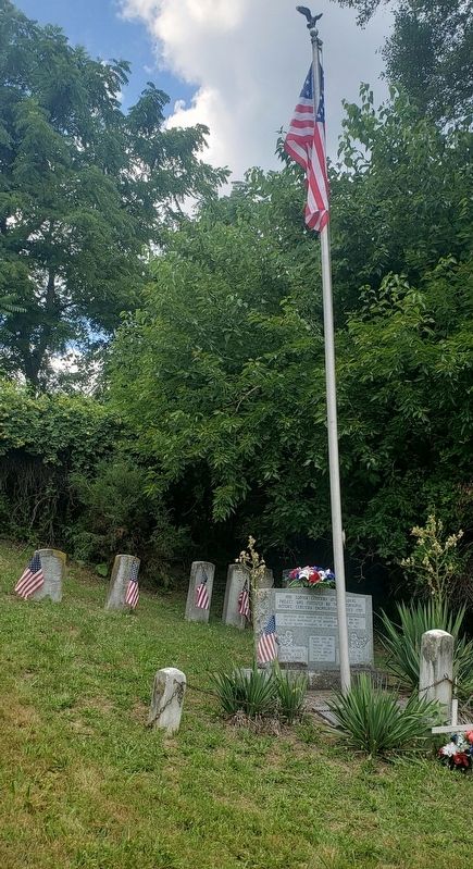
In March 1864, a regiment of United States Colored Troops (USCT) camping in Annapolis inspired William Evans, who was enslaved on this land, to self-liberate by fleeing Sandy Point to enlist in the 30th USCT. Evans was among 800 USCTs . . . — — Map (db m221221) HM
The Dr. Martin Luther King, Jr. Memorial was given to Anne Arundel Community College by the Citizens of Maryland. May this memorial remind all that visit this site, that an individual can make a difference.
At this site, anonymously buried slaves were found during road construction in 1960. These unclaimed individuals were associated with the Locust Grove plantation founded by 1848. The remains were reburied at Mt. Tabor Church in nearby Chesterfield. . . . — — Map (db m114877) HM
Many African-American families settled here more than a century ago. these families, who have lived here for four generations, are the heart and soul of this neighborhood. Their religious, educational and cultural institutions are pillars of . . . — — Map (db m5653) HM
During the 1920s, the houses on this street belonged to African-American families. Most of the men living here worked on the water, launching often home-built boats from their back yards. They harvested oysters from September to April, and crabs in . . . — — Map (db m5650) HM
Eastport's distinctive history, character and identity grew from maritime roots. The marinas that now serve pleasure boaters were once filled with wooden workboats. So crowded was the shoreline, it was said that an enterprising cat could flit from . . . — — Map (db m5890) HM
Eastport's distinctive history, character and identity grew from maritime roots. The marinas that now serve pleasure boaters were once filled with wooden workboats. So crowded was the shoreline, it was said that an enterprising cat could flit from . . . — — Map (db m5891) HM
While the plantation owner’s house was situated on a hill, African American slaves had to live in less desirable surroundings. Slave quarters were built in low, marshy area near the water. Mosquitoes and damp living conditions were a constant . . . — — Map (db m80868) HM
By 1840 there were 84 African American slaves on the Java Plantation, a large number for the area. Almost half were children. On a typical day the slaves would rise before dawn, prepare and eat breakfast, feed the livestock, and be in the fields by . . . — — Map (db m168918) HM
[Top of marker includes a logo with image of U.S. M1917/Renault FT17 light tank]
When the original Camp Meade cantonment area was built in 1917, it covered what are now the Fort Meade Golf Courses. Construction began on July 2, 1917, at . . . — — Map (db m17009) HM
The members of the Galesville Heritage Society invite you to explore their historic village. First settled in 1654 on the banks of West River, Galesville and its history are fundamentally linked to the Chesapeake Bay. Native Americans, English . . . — — Map (db m6201) HM
Freetown is one of the largest and oldest African American communities in Anne Arundel County, founded sixteen years before the start of the Civil War. The founders included free-born Blacks, formerly enslaved persons and run-aways, and indentured . . . — — Map (db m246452) HM
This historic school is a significant example of a Rosenwald School design and represents a landmark era in black education in the period before federal support of local education. The school was built in 1927 with funds raised by the local . . . — — Map (db m9035) HM
An African American community and church were established nearby in the mid 19th century. In 1918 the Benevolent Sons and Daughters of Abraham, a mutual aid society, purchased and donated land on this site for a two-room school which was built . . . — — Map (db m49729) HM
Designed by Frederick Douglass so that "As a free man I could look back across the bay to the land where I was born a slave". Built by Charles Remond Douglass. 1895 — — Map (db m6173) HM
Established in the mid 19th century on land owned by Capt. James Spencer, who served in the Union Army during the Civil War, Freetown illustrates the principles of self-sufficiency and cooperation typical of African American communities. The first . . . — — Map (db m13567) HM
The Public Park Era (1927-Present)
Recreation and places dedicated to its pursuit were a nation-wide phenomena in the early 20th Century. The shores of the Chesapeake Bay and its rivers were dotted with swimming beaches, waterfront . . . — — Map (db m98466) HM
The Patapsco Park area, widely known as Pumphrey, is an historic African American enclave with roots dating to well before the American Civil War. The largely Black community remained homogeneous for many years and prided itself with . . . — — Map (db m240357) HM
Completed in 1923 on Berlin Avenue under the Rosenwald Program, which was instrumental in the education of African Americans in the early 20th century. The fund provided matching grants for more than 5,000 schools, shops, and teachers' residences . . . — — Map (db m79728) HM
Built in 1932 on land provided by Sarah and Oscar Gaither, this three-room school, rare for the area, was the last Rosenwald school built in this county. After school consolidation, the building housed the Sunnyside School and later the Quarterfield . . . — — Map (db m244473) HM
Lynching in America
Thousands of black people were the victims of racial terror lynching in the United States between 1877 and 1950. The lynching of African Americans during this era was a form of racial terrorism intended to intimidate . . . — — Map (db m225927) HM
You just can't put your line in any place and get a crab. You got to know where they are. I could give some people my boat and line, but they'd starve to death. You have to have a feel for it.
— George Procter, age 83 . . . — — Map (db m130016) HM
A bad day on the water is better than the best day on land.
— J.R. Gross, age 32 (2000)
To make a living, a waterman thinks not in terms of weekly paychecks but rather, how much his family will bring in during the . . . — — Map (db m130004) HM
William Evans, a slave of Capt. Thomas Mezick, the owner of Sandy Point Farm here, enlisted in the 30th Regiment, United States Colored Troops, in March 1864. The 22-year-old, thereby, gained his freedom. He joined 122 other area slaves who had been . . . — — Map (db m72087) HM
Site of former major league baseball park known as Terrapin Park. Home of Federal League Baltimore Terrapins from 1914 to 1915. Built on land owned by Ned Hanlon, manager of the world champion 1890s National League Baltimore Orioles and a director . . . — — Map (db m175036) HM
William Gailes Contee and Edward Wilson Parago, Sr.
Contee-Parago Park is one of the first City parks to be named after Black Baltimoreans: Edward Wilson Parago, Sr. (1898-1983), a postal worker, and William Gailes Contee, an upholsterer . . . — — Map (db m212325) HM
"The Md. Prince Hall Masons acquired this Temple from the congregation of Oheb Shalom, November 1960, built by them in 1891." Williard W. Allen, Grand Master Emeritus Samuel T. Daniels, Grand Master — — Map (db m6551) HM
Slavery and a domestic slave trade formed essential aspects of nineteenth-century Baltimore life. Some businesses used slave labor, but most slaves worked as domestic servants for elites. In Lexington Market's precinct, for example, one in four . . . — — Map (db m243485) HM
Beginning in 1963, Market shoeshine vendor James B. Carpenter starts a daily tradition of ringing a bell that hung on Eutaw St. outside of Lexington Market at 8am sharp to signal the start of the market day.
[Caption:]
James . . . — — Map (db m243477) HM
Casting a light on the identities of two enslaved persons mentioned in 1830s-era Baltimore newspaper announcements, this piece cues onlookers to a history of Lexington Market, and more specifically, pays homage to those who had been assertively . . . — — Map (db m243524) HM
Just a few yards from this spot on September 3, 1838, Frederick Bailey, later known to the world as Frederick Douglass, escaped from slavery in Baltimore by boarding a northern train. Frederick, 20 years old, was disguised as a sailor, carrying . . . — — Map (db m212892) HM
Douglass escaped slavery with a bold plan, a clever disguise, steady nerves, and help from his friends.
At the age of 20, Frederick Bailey (as he was called) lived under slavery in Fell's Point, one mile west of this marker. He was . . . — — Map (db m212894) HM
Baltimore’s Park Commission purchased portions of the Mount Clare estate between 1890 and 1907 to provide a large landscaped park for the city’s southwestern neighborhoods. The Olmsted Brothers firm helped the city develop plans to protect the . . . — — Map (db m41430) HM
Native Americans once traversed this stream where nearby at Gwynns Run in 1669, Richard Gwinn, the stream’s namesake, established a trading post. Next to the trail today is the nine-hole executive Carroll Park Golf Course, one of the five operated . . . — — Map (db m41426) HM
Carroll Park Golf Course, a city-owned course, was purchased in 1923 for White golfers only. A group of avid African American golfers challenged the city for access through several legal actions. After much persistence, these golfers gained full . . . — — Map (db m220066) HM
In 1760, Mount Clare was built as the summer home of Charles Carroll, Barrister. Mount Clare was the center of Georgia, Charles Carroll’s 800-acre Patapsco River Plantation. The estate supported grain fields and grist mills along the Gwynn’s Falls, . . . — — Map (db m61209) HM
When leaders of First Presbyterian Church decided to build an new church atop their 18th-century burying ground, they hoped to serve Baltimore’s growing west end and protect their burial place from being diverted to other uses.
Construction . . . — — Map (db m2413) HM
Family man, attorney, civic and church leader, mentor, lover of life, thinker, stargazer
Continuing the family tradition, Charles H. Dorsey made the fight for justice his lifelong vocation. As a young man, he fought for civil rights with the NAACP . . . — — Map (db m6292) HM
The Battle Monument was America's first public war memorial and the first since antiquity to honor the common soldier. Designed by Maximilian Godefroy, its construction began in 1815, shortly after the event it commemorates: in 1814, after the . . . — — Map (db m89395) HM
Holliday Street was Baltimore’s original entertainment and cultural center. The Holliday Street Theater ...
[The rest of the inscription on the main text is not legible.]
[The inscriptions under the images on the right] 1st . . . — — Map (db m168771) HM
Harry S. Cummings was the first African American elected to the Baltimore City Council.
Born in Baltimore, Cummings received his primary education in Baltimore City public schools. He attended Lincoln University in Pennsylvania and earned . . . — — Map (db m202976) HM
[The majority of the text on the photocopy of the picture of the marker is unreadable. It ends as follows:]
His painting now hang in many museums, including the Metropolitan in New York and the National Gallery in Washington, D.C. Below are two . . . — — Map (db m9478) HM
Dedicated to the memory of the Negro Heroes of the United States.
“Sleep in Peace, slain in thy country’s wars.”
A gift to the city of Baltimore by an anonymous donor
Sculptor – James E. Lewis 1971.
(Sash held by . . . — — Map (db m8409) HM
This structure is the oldest museum building in the United States. Designed by Robert Cary Long, Sr. for Rembrandt Peale, the museum opened to the public in 1814 as "an elegant Rendezvous for taste, curiosity and leisure." For a 25-cent admission . . . — — Map (db m6305) HM
The poet, novelist, orator, and essayist was born in Baltimore on September 24, 1825, and was the only child of her free parents. After she was orphaned as a child, she lived with an aunt on Camden Street and attended a school for free African . . . — — Map (db m247692) HM
For over four decades in the early twentieth century, Druid Hill Park functioned under a policy of racial segregation. The park was heavily used during these years and African-American park users have vivid memories of the tennis courts, . . . — — Map (db m212291) HM
From 1909 to 1951, in the days of an unwritten "Jim Crow" segregation policy, the Parks Commission of Baltimore maintained "separate but equal" facilities. Druid Hill became the sole park city-wide where the African-American community felt . . . — — Map (db m7599) HM
Separate but Equal policy July 11, 1948 Participants James Robertson, Maceo Howard, Morris Kalish, James Gross, Albert Blank, Jeanette Fine, Gloria Stewart, Mary Coffee, Mitzy Freishtat, Irvin Winkler, Stanley Askin, Louis Pinkney, Leonard Collidge, . . . — — Map (db m11223) HM
Within a year of the April 1861 Baltimore Riots, the first of several U.S. Army camps and fortifications began encircling Druid Hill, and important location high above the city and adjacent to the Northern Central Railroad. The 114th and 150th . . . — — Map (db m7594) HM
836 entries matched your criteria. The first 100 are listed above. Next 100 ⊳