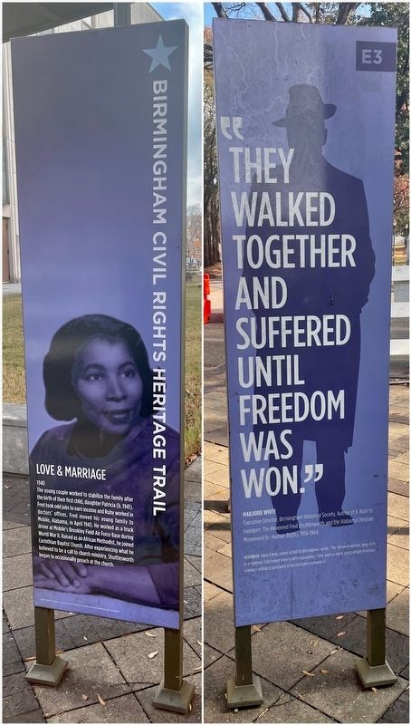
On Reverend Abraham Woods Jr Boulevard at 20th Street North, on the right when traveling east on Reverend Abraham Woods Jr Boulevard.
While working his first job after high school at the Southern Club in
Birmingham, he fell in love with a fellow co-worker, Ruby Lanette
Keeler (b. May 30, 1922). He was smitten with her beauty, complete
with dark brown skin and long wavy hair. . . . — — Map (db m187629) HM
On 19th Street North at 3rd Avenue North, on the right when traveling south on 19th Street North.
Built 1934-35 (remodeled into science center 1997), 216 19th St. N.
The Loveman's Department Store (originally Loveman, Joseph, &
Loeb), was a high-and retail store targeted for economic boycotts, pickets. "Project C" coordinators . . . — — Map (db m188173) HM
On 7th Avenue North west of 24th Street North, on the right when traveling west.
National Register of Historic Places
In many ways, the 1954 Brown v. Board of Education decision fueled the modern Civil Rights Movement. The NAACP's legal team strategically chipped away at the “separate but equal" doctrine to end . . . — — Map (db m188205) HM
On 19th Street North at 3rd Avenue North, on the right when traveling south on 19th Street North.
Music was as much a tool in the Birmingham Movement as the marches
themselves. The Movement Choir organized by the ACMHR performed
regularly during the Monday night mass church meetings. The choir
sang songs such as "God Will Make a Way Some How" . . . — — Map (db m187820) HM
On 19th Street North at 2nd Avenue North, on the right when traveling south on 19th Street North.
Built 1916, Remodeled as an IMAX Theater in 1997, 200 19th St. N.
The former Newberry's Department Store was also one of the
first major retail stores where "Project C" demonstrators staged
economic boycotts and lunch counter sit-ins to . . . — — Map (db m188072) HM
On 7th Avenue North west of 24th Street North, on the right when traveling west.
Built 1923, 2316 7th Ave N.
Phillips High School was the flagship school in the center of Birmingham. It was named for John Herbert Phillips, the city's highly-esteemed first school superintendent, who served from 1883 until his death in . . . — — Map (db m187704) HM
Some of the marchers in the Movement also went to the main Birmingham Public Library, where Blacks were not allowed to go. As always,
separate did not mean equal in Birmingham. Its Black citizens had a
small library located in rented space at the . . . — — Map (db m187830) HM
On 19th Street North at 3rd Avenue North, on the right when traveling north on 19th Street North.
Built 1937, 301 19th St. N.
The S. H. Kress store was another site of economic boycotts
and lunch counter sit-ins during the student-led protests of
Miles College students and their leader Frank Dukes in 1962 and
“Project C” in 1963. Retail . . . — — Map (db m188176) HM
On 22nd Street North at 7th Avenue North, on the left when traveling north on 22nd Street North.
Birmingham had the well-earned reputation of being America's deadliest
defender of segregation in the 1950s and 1960s. Civil rights leaders Rev.
Fred Shuttlesworth, head of the local Alabama Christian Movement for
Human Rights (ACMHR) and Dr. . . . — — Map (db m187681) HM
On Park Place east of 20th Street North, on the left when traveling east.
Many social scientists of the early 20th century promoted the false
belief that Blacks were intellectually and socially inferior to Whites and
fit only for service jobs. Blacks, therefore, did not deserve to be educated on the same level as . . . — — Map (db m187633) HM
On 19th Street North at 3rd Avenue North, on the right when traveling north on 19th Street North.
The mass demonstrations of “Project C” forced White Birmingham's
elite business leaders and downtown merchants back to the bargaining
table in May 1963. Once again, leaders of Black Birmingham's power
structure presented a list of demands in . . . — — Map (db m187828) HM
On 19th Street North at Reverend Abraham Woods Jr Boulevard, on the right when traveling north on 19th Street North.
1955
After arriving in Birmingham, Rev. Shuttlesworth
became active with the local NAACP and became its
membership chair. He organized 76 Birmingham
ministers to petition Birmingham's commissioners to
hire Black police officers. The petition . . . — — Map (db m187625) HM
On 19th Street North north of Reverend Abraham Woods Jr Boulevard, on the right when traveling north.
By mid-1956, the Montgomery Bus Boycott was crippling that city's economic
base. To stop its success, pro-segregationists searched for a legal loophole to block the NAACP, one of the boycott organizers. That loophole was that it had failed to . . . — — Map (db m187605) HM
On 19th Street North north of 2nd Avenue North, on the right when traveling north.
On February 1, 1960, four Black college students in Greensboro, North Carolina, sat down at Woolworth's "Whites Only" lunch counter. This started a national movement where Blacks used sit-ins as a direct, non-violent action to combat segregation . . . — — Map (db m187827) HM
In response to oppressive jobs and livelihoods such as sharecropping and tenant farming during post-Civil War Reconstruction, large numbers of African American and poor families from the Black Belt regions began to migrate towards northern, more . . . — — Map (db m220602) HM
On 19th Street North south of 4th Avenue North, on the right when traveling north.
The Birmingham Movement was a defining moment for African
Americans determined to win equal citizenship in their own country.
Pictures and stories from the Birmingham struggle touched the hearts of
the nation and the world. Often injured by . . . — — Map (db m188908) HM
On 7th Avenue North west of 23rd Street North, on the right when traveling west.
In Alabama, White parents used the 1956 Alabama Pupil Placement Act that
let them “choose” which public schools their children would attend. When
Black parents in Birmingham tried to use the same law to send their children
to White schools, . . . — — Map (db m187685) HM
On 20th Street North 0.1 miles north of Park Place, on the right when traveling north.
Young Fred loved pulling pranks with the aid of his younger siblings
and friends. He enjoyed going to church every Sunday and began
teaching Sunday School. Because he was so mischievous, his siblings
could hardly believe that his secret goal was . . . — — Map (db m187630) HM
On Park Place east of 20th Street North, on the left when traveling east.
Thirteen years after the American Civil War, the U.S. Supreme Court
began to uphold Jim Crow segregation laws that kept African Ameri-
cans from enjoying their 14th Amendment rights. Its famous Plessy v.
Ferguson decision in 1896 supported a . . . — — Map (db m187632) HM
Another strategy of “Project C” was voter registration for Birmingham
Blacks. At the time, only 12,000 of 150,000 voting-age African-Americans
in Jefferson County could vote. White state and local officials used such
methods as reading tests and . . . — — Map (db m187708) HM
On 22nd Street North south of 7th Avenue North, on the right when traveling south.
Southern governors, mayors and elected officials employed every means to
resist public school integration, even famously using armed state guards to
block Black students from entering. For example, Arkansas Gov. Orval Faubus
called the Arkansas . . . — — Map (db m187680) HM
On 20th Street North north of Park Place, on the right when traveling north.
"Bull” Connor's police force still tried in vain to stop the marches to
City-Hall. The number of well-organized protestors overwhelmed
the police. Some marchers actually made it to Woodrow Wilson
Park (now Linn Park) that connects City Hall and . . . — — Map (db m187706) HM
On Center Street at 10th Court North, on the right when traveling north on Center Street.
1949
For four decades, Shores was deeply involved in civil
rights challenges handling dozens of cases primarily
for the Birmingham branch of the NAACP on behalf of
African Americans. In the 1940s, the Birmingham
NAACP had grown to more . . . — — Map (db m189188) HM
On Center Street south of 9th Alley West, on the right when traveling south.
1937
Most of Birmingham's housing started as cheap,
poorly built living quarters that large coal and
mining companies created near their factories for
their workers. Living in camp town housing
carried a stigma that many Blacks and . . . — — Map (db m189162) HM
On Center Street at 10th Alley West, on the right when traveling south on Center Street.
1955
By the 1950s, North Smithfield was the residential
area of choice for a new generation of Black
middle-class families, despite the terror bombings
meant to scare them away. This new generation of
African American leaders included A. . . . — — Map (db m189171) HM
On Center Street north of 10th Court North, on the right when traveling north.
As both a lawyer and Smithfield real estate developer,
Arthur Davis Shores' story is also the story of Dynamite
Hill. He played a central role in African Americans' legal
fight to build and buy houses where they wished,
including the “White . . . — — Map (db m189185) HM
On 8th Avenue West at 3rd Street West, on the right when traveling west on 8th Avenue West.
On September 4, 1963, Graymont Elementary
School was the first public school in Birmingham
to be racially integrated. Two brothers, nine and
eleven years old, accompanied by their father,
James Armstrong, along with Reverend Fred . . . — — Map (db m153229) HM
On Center Street north of 10th Avenue North, on the right when traveling north.
The explosions in August and the deaths of the girls
and two boys in acts of violence on September 15,
all attached to school integration in 1963, deeply
shook Birmingham. The violence stoked deep
resentment and anger in the Black . . . — — Map (db m189191) HM
On Center Street south of 10th Court West, on the right when traveling south.
1953
During the early 1950s, moderate White business
leaders pressured city officials to find and prosecute
the Dynamite Hill bombers and explore racial
reforms. In April 1951, some worked with moderate
Blacks to form the Interracial . . . — — Map (db m189176) HM
On Center Street north of 10th Avenue North, on the right when traveling north.
August 1963
The Shores daughters said their father handled civil
rights cases across Alabama and across the South. As he
advanced the African American struggle against unfair
segregation through the courts, angry White militants
turned . . . — — Map (db m189189) HM
On 29th Avenue North west of 33rd Street North, on the left when traveling west.
Rev. Shuttlesworth and his fellow ministers agreed to call the
replacement organization the Alabama Christian Movement for Human
Rights (ACMHR) so that its reach was both statewide and its aims wider
than the African American community. Adding . . . — — Map (db m188971) HM
On 29th Avenue North west of 33rd Street North, on the left when traveling west.
The ACMHR used nonviolent direct action as its preferred method of
attacking racial segregation. This was a clear break from the tactics and
strategies of the traditional black middle-class leadership that focused
on petitions and lawsuits. Under . . . — — Map (db m188978) HM
On 28th Avenue North at 33rd Street North, on the right when traveling west on 28th Avenue North.
Rev. Shuttlesworth returned frequently to Birmingham to lead the
ACMHR in a strategic alliance with the SCLC to bring national attention to
Birmingham and the need to end racial discrimination in America.
ACMHR staff worked with the SCLC's . . . — — Map (db m189139) HM
On 28th Avenue North east of 32nd Street North, on the left when traveling east.
Because of his fearlessness, college student activists who staged
sit-ins and integrated bus rides in the 1960s knew they could depend
on support from Rey. Shuttlesworth and the ACMHR. He supported
Miles College student leader Frank Dukes and his . . . — — Map (db m189134) HM
On 29th Avenue North west of 33rd Street North, on the left when traveling west.
Alabama's chapters of the National Association for the Advancement
of Colored People (NAACP) were particularly effective in filing federal
lawsuits that challenged racial segregation laws and advocating for
voting rights. NAACP members also . . . — — Map (db m188970) HM
On 32nd Street North at 29th Avenue North, on the left when traveling south on 32nd Street North.
In January 1957, Dr. Martin Luther King, Jr., called ministers of the
church-led movements in Southern cities, including Montgomery and
Birmingham, to a meeting in Atlanta to form a national organization to
help them all. Civil rights activist . . . — — Map (db m189109) HM
On 29th Avenue North at 33rd Street North, on the left when traveling west on 29th Avenue North.
Birmingham's rise to national prominence in the modern American
Civil Rights Movement began several years after Rev. Fred L.
Shuttlesworth arrived in March 1953 to pastor Bethel Baptist Church,
founded in 1904. The church's prior pastors were . . . — — Map (db m188962) HM
On 32nd Street North south of 29th Avenue North, on the left when traveling south.
A key reason for Rev. Shuttlesworth's success was that he led the ACMHR
by example. He was the first to put himself, even his family, in harm's
way for the sake of the Movement. He did not ask ACMHR members to
do anything he was not willing to do . . . — — Map (db m189112) HM
On 32nd Street North south of 29th Avenue North, on the left when traveling south.
Another goal of the ACMHR was school desegregation. ACMHR members
like barber James Armstrong filed lawsuits to put their children in
better-funded all-White schools after the U.S. Supreme Court's
landmark 1954 decision in Brown v. Board of . . . — — Map (db m189114) HM
On 28th Avenue North east of 32nd Street North, on the left when traveling west.
1962
Segregation was still a way of life despite the ACMHR's heroic and
dangerous direct action campaigns and its multiple lawsuits.
Rev. Shuttlesworth knew he needed to put more pressure on the
city. He and other ACMHR leaders spent . . . — — Map (db m189137) HM
On 29th Avenue North at 33rd Street North, on the right when traveling east on 29th Avenue North.
Rev. Fred Shuttlesworth's tenure as pastor of Bethel Baptist Church (1953-1961) was marked by demonstrations, bombings and passionate sermons critical of segregation laws. His activism earned him a house bombing, frequent beatings, arrests, and . . . — — Map (db m83836) HM
On 29th Avenue North west of 33rd Street North, on the left when traveling west.
In November 1956, the U.S. Supreme Court outlawed segregated buses
in Montgomery, handing the bus boycott and the growing Civil Rights
Movement a major victory. As a result, Rev. Shuttlesworth led the
ACMHR to target Birmingham's segregated . . . — — Map (db m189098) HM
On 29th Avenue North west of 33rd Street North, on the left when traveling west.
The Christmas night bombing by White terrorists was intended to kill
Rev. Shuttlesworth, or at the very least, to scare him into leaving town
and his new organization. A police officer who came to the bornbed
house and church told Rev. . . . — — Map (db m189105) HM
On 28th Place North east of 32nd Street North, on the left when traveling east.
In late 1958 and the summer of 1959, a series of articles in Time
magazine and the New York Times addressed the dangers Black
church leaders and others involved in the Movement faced as angry
pro-segregation Whites took more and more violent . . . — — Map (db m189131) HM
On 28th Avenue North east of 32nd Street North, on the left when traveling east.
June 1958
Rev. Shuttlesworth called 1958 “a year of harassment” as terrorist
violence against the ACMHR's movement grew worse. Bethel
Baptist Deacon James Revis offered his home near the new
parsonage as a guardhouse. Other men from the . . . — — Map (db m189119) HM
On 29th Avenue North west of 33rd Street North, on the left when traveling west.
The "sudden" emergence of the ACMHR ministers left White leaders
"dumbfounded” and deeply concerned about how they could be
controlled. At first, they called Rev. Shuttlesworth and his fellow
ministers “radicals” and “Communists," "outsiders” who . . . — — Map (db m189084) HM
On 19th Street North at 12th Avenue North, on the right when traveling north on 19th Street North.
Although Rev. Shuttlesworth resigned from his positions within
the ACMHR and the SCLC in 1969, his dedication to the cause of
equality for African Americans continued for decades after the
height of the American Civil Rights Movement. A split . . . — — Map (db m187576) HM
On 19th Street North north of 11th Avenue North, on the right when traveling north.
"Project C” and the bombing of Sixteenth Street Baptist Church were
powerful motivators to end racial discrimination in America, but they
were not enough a year later. Even after the assassination of President
Kennedy on November 22, 1963, . . . — — Map (db m187591) HM
On 19th Street North at F L Shuttlesworth Drive, on the right when traveling north on 19th Street North.
One of the last major battles in the struggle for African American civil
rights came in Selma, Alabama. Despite the new Civil Rights Act of
1964, African Americans still faced difficulty voting. Although they
had the right to vote under the . . . — — Map (db m187587) HM
On 19th Street North north of F L Shuttlesworth Drive, on the right when traveling north.
Birmingham's new leaders were much kinder to Rev. Shuttlesworth than their
predecessors. In 1978, officials renamed one of the city's main roads in his
honor. The city's first African-American mayor, Richard Arrington, Jr.,
requested his return . . . — — Map (db m187573) HM
On 19th Street North at 11th Avenue North, on the right when traveling north on 19th Street North.
In 1961, Rev. Shuttlesworth finally gave in to his wife Ruby's wishes to leave
Birmingham to become pastor of Revelation Baptist Church in Cincinnati.
But he returned to Birmingham often to organize the Monday night mass
meetings and lead the . . . — — Map (db m187597) HM
Near 12th Avenue North at Cahaba Street, on the left when traveling east.
Marker Front:
Founded in 1886 on 600 acres of land, East Birmingham was the agricultural area consisting primarily of dairy farms extending to the present Birmingham airport. The East Birmingham Land Company that developed the area was . . . — — Map (db m83827) HM
On Center Street 0.2 miles north of 10th Court North, on the right when traveling north.
1961
Black middle-class families who moved to North
Smithfield included the Davises, the Coars, the
Monks, the Browns, the Coles, the Adamses, the
Wesleys, the Gaillards, the Powells, the Halls, the
Nalls, the Browns, the Nixons, the . . . — — Map (db m189181) HM
On Center Street 0.1 miles north of 10th Court West, on the right when traveling north.
September 1963
The increasing number of new African American
families moving onto Dynamite Hill required the
building of a new school. The city's segregation
laws prevented their children from attending
all-White Graymont Elementary, even . . . — — Map (db m189184) HM
On Center Street at 11th Court West, on the right when traveling south on Center Street.
1960
This Center Street Historic District was carved from the
plantation of Joseph Riley Smith, who subdivided 600
acres that became Smithfield in 1886. In 1898, the
Smithfield community was home to many Whites,
including Italian and . . . — — Map (db m189177) HM
On Center Street near 11th Court West, on the right when traveling north.
1946
This two-story Queen-Anne-style house at the
corner of Center Street and 11th Court North was built
around 1900 for the Hayes family. White neighbors
objected when they learned the Hayes family sold
their house to a Black couple, . . . — — Map (db m189180) HM
On 20th Street (Alabama Route 269) at Ensley/5 Points W Avenue, on the right when traveling west on 20th Street. Reported missing.
"Tuxedo Junction" was the street car crossing on the Ensley-Fairfield line at this corner in the Tuxedo Park residential area. It also refers to the fraternal dance hall operated in the 1920's and 1930s on the second floor of the adjacent building, . . . — — Map (db m25623) HM
On 6th Avenue South at 9th Street South, on the right when traveling east on 6th Avenue South.
The New Pilgrim Baptist Church
Civil Rights Gathering Place.
This church served as a gathering place and strategic hub for Birmingham's Civil Rights Movement in 1956 under the leadership of Rev. Nelson H. Smith, Jr., . . . — — Map (db m188891) HM
On 4th Avenue North at 17th Street North, on the right when traveling west on 4th Avenue North.
The Fourth Avenue "Strip" thrived during a time when downtown privileges for blacks were limited. Although blacks could shop at some white-owned stores, they did not share the same privileges and services as white customers, so they created . . . — — Map (db m26985) HM
On 4th Avenue North west of 17th Street North, on the left when traveling west.
Built in 1935, remodeled 1945 (corner 4th Ave. N. & 17th St. N.)
The Carver Theatre for the Performing Arts was built in 1935 and
refitted in 1945 with all of the modern comforts and features of the
day, including 1,300 theatre chairs and . . . — — Map (db m188189) HM
On 18th Street North at 3rd Avenue North Alley, on the left when traveling north on 18th Street North.
Built 1913, 310 18th St. N.
The Alabama Penny Savings Bank, founded by Sixteenth Street
Baptist Church pastor Rev. William R. Pettiford, was Alabama's
first Black-owned bank and the second-largest Black bank in the
country by 1907. He . . . — — Map (db m188950) HM
On 5th Avenue North, on the right when traveling east.
During the first 30 years of his 54-year-old practice, Attorney Shores practiced all over the State of Alabama - from the Tennessee line to the Gulf of Mexico at Mobile Bay, and from the Mississippi borders to the Georgia limits. During the period . . . — — Map (db m26720) HM
Built 1940, 1420 7th Ave. N.
The Ballard House honors a time when thriving
neighborhoods; businesses, churches, social, cultural,
and civic organizations; made up a dynamic
African-American community during the first half of
the 20th . . . — — Map (db m187886) HM
On 6th Avenue North at 16th Street North, on the left when traveling west on 6th Avenue North.
Built 1992, 520 16th St. N.
The Birmingham Civil Rights Institute contains permanent exhibitions and photo galleries, offering visitors a self-directed
journey through the Civil Rights Movement of the 1950s and
1960s to the human rights . . . — — Map (db m187515) HM
On 6th Avenue North west of 17th Street North, on the left when traveling west. Reported damaged.
Civil rights activist and pastor, the Rev. Calvin Wallace Woods Sr. was born in Birmingham in 1933. The son of a Baptist preacher, Woods attended historic miles college and various seminary institutions. He distinguished himself as a leader during . . . — — Map (db m187533) HM
On 5th Avenue North at 16th Street North, on the left when traveling east on 5th Avenue North.
The economic center of the Black retail district was on nearby Fourth
Avenue North. This historic area also served as the main cultural, social
and religious center of Black Birmingham. Blacks felt more relaxed
among their own people in and . . . — — Map (db m187761) HM
The Brock building was established in 1915, located at the intersection of Fourth Avenue and 18th Street North, was built while the area was residential. The three-story building housed a hotel upstairs that catered to professional musicians and . . . — — Map (db m26723) HM
On 5th Avenue North at 16th Street North, on the left when traveling east on 5th Avenue North.
In Tribute to
Carrie A. Tuggle
1858 - 1924
Scholar, Teacher and Christian.
A life of unselfish service
to the troubled and the
homeless black boys and girls.
In 1903, she founded
a school and orphanage,
the Tuggle . . . — — Map (db m27391) HM
On 6th Avenue North west of 19th Street North, on the left when traveling west.
The use of schoolchildren in the Movement unnerved Police Commissioner "Bull” Connor, as well as the rest of Birmingham. But the success
of “D-Day” led to a second day, “Double D-Day," where more children,
about 2,000, skipped school to protest. . . . — — Map (db m187838) HM
On 5th Avenue North east of 16th Street North, on the left when traveling east.
Rev. Bevel gave Birmingham children a chance to play important roles in
the struggle for equality. As their field marshal, he turned hundreds of
recruits into an effective non-violent army that “Project C" unleashed
on the retail district. Images . . . — — Map (db m187767) HM
On 4th Avenue North at 17th Street North, on the right when traveling west on 4th Avenue North.
Built 1922, 1630 4th Ave. N.
Built and designed by African Americans, the Colored Masonic
Temple served as their only major business and social meeting
place for decades. The Temple's gilded auditorium hosted many elegant social functions . . . — — Map (db m188188) HM
On 5th Avenue North at 19th Street North, on the left when traveling east on 5th Avenue North.
In the 1940s and 1950s, the NAACP filed a stream of lawsuits against Jim
Crow laws that had given Whites political, economic and social
superiority over Blacks for more than 100 years. Most of Birmingham's
NAACP cases, filed by local Black . . . — — Map (db m187775) HM
On 19th Street North north of F L Shuttlesworth Drive, on the right when traveling north.
Rev. Shuttlesworth often said he expected to die at an early age in his
toe-to-toe battles with violent White segregationists who were bent on
maintaining power. But he outlived Dr. King and Rev. Abernathy, the last of
"the Big Three." He lived . . . — — Map (db m187571) HM
On 6th Avenue North at 17th Street North on 6th Avenue North.
Leaders of the Southern Christian Leadership Conference (SCLC) learned they could apply economic pressure to White businesses with more effective results than moral persuasion alone. Therefore, the central strategy of the Birmingham Campaign . . . — — Map (db m73037) HM
Born Jan. 15, 1929 Assassinated Apr. 4. 1968 "...yes, if you want to say that I was a drum major, say that I was a drum major for justice; say that I was a drum major for peace..." His dream liberated Birmingham from itself and began a . . . — — Map (db m73007) HM
Rev. Fred Shuttlesworth invited Dr. Martin Luther King, Jr. to Birmingham in 1962. Shuttlesworth saw potential in the young minister, and their combined efforts were instrumental in Birmingham's desegregation. The campaign catapulted King into the . . . — — Map (db m73031) HM
Near 5th Avenue North at 16th Street North, on the left when traveling east.
Dedicated to
Dr. Ruth J. Jackson
1898-1982
This woman of strength and vision graduated from the Poro School of Cosmetology, the first black registered school in the State of Alabama. At the vanguard of the Civil Rights Movement, she was . . . — — Map (db m27090) HM
On 4th Avenue North at 17th Street North, on the left when traveling west on 4th Avenue North.
Built 1917, 1701 4th Ave. N.
From 1900 to 1960, the Fourth Avenue area west of 18th Street in
downtown Birmingham was the business, social and cultural center
of the city's African-American community. Every major historical
and cultural . . . — — Map (db m188039) HM
On 4th Avenue North at 18th Street North, on the left when traveling west on 4th Avenue North.
Eddie James Kendrick, nicknamed "cornbread", was born the eldest of five children to Johnny and Lee Bell Kendrick in Union Springs, Alabama.
After attending Western-Olin High School in Ensley, Alabama, Eddie was persuaded by his childhood . . . — — Map (db m26724) HM
On 4th Avenue North west of 18th Street North, on the left when traveling west.
Built 1999, SW corner of 4th Ave. N. & 18th St. N.
Urban Impact worked with artist Ronald McDowell who wanted
to create a public park along Fourth Avenue to honor Eddie
Kendricks, Birmingham native and a lead singer of the
legendary Motown . . . — — Map (db m188036) HM
On 17th Street North, on the right when traveling south.
Emory Overton Jackson was born on September 8, 1908 in Buena Vista, Georgia to Will Burt and Lovie Jones Jackson. E. O. Jackson and his seven siblings were raised in the middle-class Birmingham enclave of Enon Ridge, located on the west side of town . . . — — Map (db m64736) HM
On 19th Street North at 3rd Avenue Alley North, on the left when traveling south on 19th Street North.
Constant mistreatment by a brutal police force, a racist state government
and a White community that was either hostile or unconcerned pushed
many Blacks in Birmingham to the breaking point. Many were stuck in
low-paying, low-level jobs. Most . . . — — Map (db m187785) HM
On 4th Avenue North west of 18th Street North, on the left when traveling west.
Built 1928, 1717 4th Ave. N.
During the entertainment boom of the 1920s, The Famous, an
African-American movie theater, joined the Frolic, Lincoln,
Champion, Dixie and Savoy Theaters as places of entertainment
for African-Americans who . . . — — Map (db m188038) HM
Near 5th Avenue North at 16th Street North, on the right when traveling east.
This sculpture is dedicated to the Foot Soldiers of the Birmingham Civil Rights Movement.
With gallantry, courage and great bravery they faced the violence of attack dogs, high powered water hoses, and bombings. They were the fodder in the . . . — — Map (db m27394) HM
On 4th Avenue North at 17th Street North, on the right when traveling west on 4th Avenue North.
Prior to 1900 a "black business district" did not exist in Birmingham. In a pattern characteristic of Southern cities found during Reconstruction, black businesses developed alongside those of whites in many sections of the downtown area. . . . — — Map (db m174706) HM
On 4th Avenue North west of 17th Street North, on the right when traveling west.
The Fraternal Hotel Building was built in 1925. Some of the businesses that were located in this building included:
1925 - 1980 Fraternal Hotel
1925 - 1970 Fraternal Café
1950 - 1966 Monroe Steak House
1985 - 1994 Grand Lodge Knights of . . . — — Map (db m27518) HM
On 4th Avenue North, on the left when traveling west.
Businesses that occupied this building between 1908 - 1970
1908 - 1913 Southern Bell Telephone Company Stockroom
1915 - 1926 OK French Dry Cleaning Company
1927 - 1938 George Kanelis Billiards
1940 - 1945 Alex’s Steak House
1946 - . . . — — Map (db m27521) HM
On 19th Street North at 7th Avenue North, on the right when traveling south on 19th Street North.
Built 1950 (Remodeled in the 1970s), 618 19th St. N.
The Greyhound bus station was a stop of the 1961 Freedom Riders, a
group of Blacks and Whites who rode buses together across state
lines to disobey segregation laws in the Deep South. A . . . — — Map (db m187718) HM
You are standing at Ground Zero of the 1963 civil rights struggle in Birmingham. When African-American leaders and citizens resolved to fight the oppression of a strictly segregated society, they were met with vitriol and violence despite their own . . . — — Map (db m73015) HM
On 16th Street North south of 6th Avenue North, on the left when traveling south.
Unfair laws forced Birmingham Blacks to create their own distinctive
world of economic and social self-reliance. The historic Black business
district extended several blocks around Kelly Ingram Park and contained
a concentration of Black-owned . . . — — Map (db m187760) HM
On 6th Avenue North at 16th Street North on 6th Avenue North.
The first march to City Hall was organized in 1955 by Rev. Fred L. Shuttlesworth when he petitioned the city to hire Negro policemen. By 1963, thousands of Blacks marched on City Hall to protest Jim Crow laws that were a constant reminder of Blacks' . . . — — Map (db m73036) HM
On 19th Street North north of Park Place, on the left when traveling north.
People across the country took notice of the Birmingham demonstrations.
Donations began pouring in to help post bail for hundreds of marchers,
mostly children. Local leaders estimated the amount for bail at well over
$200,000. As anger grew in . . . — — Map (db m187835) HM
In dedication to Julius Ellsberry, the first Black Alabama man to die in World War II; born Birmingham, Ala, 1922.
Enlisted in the U.S. Navy, 1940; First Class Mate Attendant aboard battleship Oklahoma in the Battle of Pearl . . . — — Map (db m63761) HM WM
On 16th Street North south of 6th Avenue North, on the right when traveling south.
Built 1871 (renovated from 1979 to mid-1990s),
1601 & 1630 6th Ave. N.
Kelly Ingram Park was the main battleground in the 1963
Birmingham Campaign, dubbed “Project C" (with “C”
meaning "Confrontation"). The campaign was the . . . — — Map (db m187845) HM
Responsible for much planning and leadership, the clergy played a central role in the Birmingham Campaign--like the famous Palm Sunday incident in 1963 (see nearby plaque). Local clergy like Rev. Fred Shuttlesworth worked with out-of-town ministers, . . . — — Map (db m73080) HM
On 19th Street North south of 3rd Avenue North, on the right when traveling south.
The non-violent marches for freedom in Birmingham inspired sympathy
demonstrations in Alabama, across the United States and around the
world. Average Americans began to insist that the federal government
step in to guarantee Blacks their rights . . . — — Map (db m187821) HM
On 5th Avenue North east of 18th Street North, on the left when traveling east.
Dr. Martin Luther King, Jr. replaced his initial reluctance to using
"children as foot soldiers' with approval. Thousands of newly recruited
child foot soldiers successfully marched toward the retail district, with
hundreds arrested for the . . . — — Map (db m187773) HM
On 5th Avenue North east of 17th Street North, on the left when traveling east.
Rev. Bevel and his SCLC team targeted high school students such as
cheerleaders, football players and other student leaders as foot soldiers
in the Movement. These popular teens could influence their peers to join
the sit-ins, pickets and . . . — — Map (db m188922) HM
On 6th Avenue North west of 19th Street North, on the left when traveling west.
On nightly news programs and in newspapers, the images of Birmingham
children under police attack shocked and sickened the nation. It was the
reaction that “Project C” organizers had hoped for. The "Children's Crusade” revived the Birmingham . . . — — Map (db m187837) HM
On 4th Avenue North at 16th Street North, on the right when traveling west on 4th Avenue North.
Built 1955, 1530 4th Ave. N.
Metropolitan AME Zion Church was one of the Movement
churches, hosting ACMHR mass meetings in 1962 and serving as
one of the starting points of the massive demonstrations of
April - May 1963. “Project C" . . . — — Map (db m188033) HM
15074 entries matched your criteria. Entries 201 through 300 are listed above. ⊲ Previous 100 — Next 100 ⊳