On South 2nd Street just south of Madison Street, on the right when traveling south.
The first election was held in 1833 at the Jeremiah Roe home. Samuel Rugg was appointed Justice of the Peace, David McKnight was appointed first Sheriff. The first County Election was held June 23, 1836.
The officials were: . . . — — Map (db m211668) HM
Architect Eric R. Kuhne was commissioned to design a flood control plan that would provide for a park and premier festival center. It could also serve as a model for flood control in other sections of the country. The Headwaters Park Commission was . . . — — Map (db m17037) HM
Because of the often soggy conditions that discouraged use as either residential or commercial property, the area of Headwaters Park became known as the Jail Flats. The first jail in Allen County was a two-story hewn-log structure that was enclosed . . . — — Map (db m197061) HM
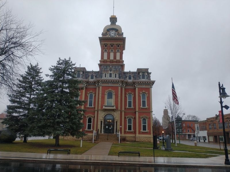
On East Berry Street west of South Clinton Street (U.S. 27), on the right when traveling west.
1863 marked the beginning of the first organized Police Force in the city. The council named a captain and three patrolmen to serve from twilight to daybreak. On this site was located the first city Police Station. It contained three iron cages on . . . — — Map (db m44086) HM
On E. Berry Street, on the left when traveling east.
The Fort Wayne City Building, later called "The
Old City Hall,” was designed by local architects John
Wing and Marshall Mahurin and was dedicated on
April 20, 1893, by Mayor Charles Zollinger.
Called by some "The Hapsburg Horror” as a . . . — — Map (db m197283) HM
On Washington Street south of 3rd Street, on the right when traveling south.
County formed by Indiana General Assembly 1821. Thirty acres of land were purchased, and John Tipton donated thirty acres, for county seat. State commissioners named county seat Tiptona — after Tipton; local elected commissioners renamed it . . . — — Map (db m48105) HM
On East 6th Street west of South Grant Avenue, on the right when traveling west.
Benton County formed by General Assembly in 1840. Oxford first county seat; Fowler became second, 1874. Designed in Second Empire Style by Gorden P. Randall and built 1874 by Levi L. Leach. Located at geographical center of county on land donated by . . . — — Map (db m21487) HM
On State Road 18 west of County Road N200W, on the right when traveling east.
In October 1818, Purchasing Commissioners Lewis Cass, Benjamin Parke and Governor Jonathan Jennings acquired Indian claims on the land shown on this marker. About one-third of modern Indiana, was involved in this transaction. — — Map (db m21517) HM
On South Lebanon Street (State Road 39) south of South Street (State Road 32), on the right when traveling south.
Enroute to Washington, D.C., to become 16th President of the U.S., addressed citizens of Lebanon and Boone County from rear of railroad passenger car at this place on the evening of February 11, 1861. — — Map (db m3811) HM
On West Main Street just east of North Lebanon Street (Indiana Route 39), on the right when traveling west.
A progressive politician and lifelong Democrat, Ralston met the challenges posed by Indiana’s transition to a more urban and industrial state. Born 1857 in Ohio, he opened a law office in 1886 in Lebanon, where he lived until elected governor in . . . — — Map (db m175673) HM
On South Main (County Route 650E) at Linville Avenue, on the right when traveling north on South Main.
Albert S. White, for whom Whitestown is named, was president of the Indianapolis & Lafayette Railroad. White was a United States senator and Representative from Indiana and a leading abolitionist. He was appointed to a select federal commission by . . . — — Map (db m175788) HM
On South Main Street (County Route 650E) just south of Linville Avenue, on the right when traveling south.
Commemorating the historic Lafayette & Indianapolis Railroad. On May 1st, 1865, at 1:07a.m., the Lincoln Funeral Train passed through Whitestown with mourners lining the tracks in the middle of the night to pay homage to the assassinated 16th U.S. . . . — — Map (db m175790) HM
Near South First Street at West Oak Street, on the left when traveling north.
Abraham Lincoln enroute to Washington as President Elect on February ll, 1861 addressed the Citizens of Zionsville at the Railroad Depot which stood on this site. — — Map (db m8326) HM
On South Washington Street south of East Franklin Street, on the right when traveling north.
Delphi City Hall
has been placed on the
National Register
of Historic Places
by the United States
Department of the Interior
1865 — — Map (db m159804) HM
On West Main Street (U.S. 421) just east of South Washington Street, on the right when traveling west.
Delphi Courthouse Square Historic District
has been placed on the
National Register
of
Historic Places
by the United States
Department of the Interior
— — Map (db m161448) HM
Samuel Milroy was born 1780 in Pennsylvania and is a "Child of the American Revolution". His father served as a Patriot in the war for Independence. In 1826, at the age of 46, Samuel moved to Carroll County and built a cabin, which was located on . . . — — Map (db m213303) HM
On 4th Street at North Street, on the right when traveling south on 4th Street. Reported permanently removed.
( Clock Tower - Plaque )
This tower was erected in honor of the military veterans of Cass County. The clock and bell were salvaged from the old Cass County Court House, originally built in 1844, subsequently added to in 1888, and finally . . . — — Map (db m208897) HM WM
On South 6th Street north of East Market Street, on the right when traveling north.
Declaration of Independence
drafted by Thomas Jefferson
Between June 11 and June 28, 1776, the continental congress adopted the Declaration of Independence on July 4, 1776. It was engrossed on parchment, and on August 2, 1776, delegates . . . — — Map (db m243065) HM WM
On Market Street (State Road 3) 0.2 miles south of Clark Road, on the right when traveling south.
Indiana Territorial Delegate to
Congress, 1809-1816.
President of Indiana Constitutional
Convention, June, 1816.
First Governor of Indiana, 1816-1822.
Member of Congress, 1822-1830. — — Map (db m206887) HM
On Water Street at Harrison Street, on the right when traveling west on Water Street.
Built in 1812 by James Bigger
Scene of inaugural ball
held in 1816 for Jonathan Jennings
Indiana's first governor
and scene of infare for his marriage
with Clarissa Barbee in 1826 — — Map (db m206889) HM
On East Court Avenue at Spring Street, on the left when traveling east on East Court Avenue.
Jeffersonville is named for President Thomas Jefferson, who had a profound influence on the city. As a Virginia legislator, Jefferson was a strong supporter of General George Rogers Clark's Illinois campaign from 1778 to 1779, which resulted in the . . . — — Map (db m241638) HM
On East Court Avenue at Spring Street, on the right when traveling west on East Court Avenue.
Thomas Jefferson was born on April 13, 1743 in Shadwell, Virginia. He was a draftsman of the U.S. Declaration of Independence; the nation's first secretary of state (1789-94); second vice president (1797-1801); and as the third president . . . — — Map (db m245086) HM
On East Court Avenue west of Wall Street, on the right when traveling west.
Named in honor of
Luther Fairfax Warder
Mayor of Jeffersonville, six (6) terms
(1875 – 1883 ) – • – (1887 – 1891)
He converted the small town into a prosperous, progressive city, was foremost in bringing the . . . — — Map (db m46767) HM
On East National Avenue west of South Harrison Street, on the left when traveling west.
County formed by Indiana General Assembly 1825; named for national statesman Henry Clay. First county seat at Bowling Green; had three courthouses: first built 1827 was two-story log structure; second and third built 1839-1840 and 1852-1853 were . . . — — Map (db m18883) HM
On Road W660N at Road 150W, on the left when traveling west on Road W660N.
Side A
Homer E. Capehart
Born into Indiana farming family 1897. Manufactured and pioneered sales of automatic phonographs, creating Capehart Corporation. Executive of Rudolph Wurlitzer Company 1933-1944. Organized 1938 Republican . . . — — Map (db m23206) HM
On Road 56 south of 5th Street, on the right when traveling north.
Aurora was laid out by Jesse L. Holman, trustee for the “Aurora Association for Internal Improvements” in 1819. Judge Holman was an early statesman, preacher, educator, and federal justice.
His son, U.S. Congressman William S. Holman served . . . — — Map (db m22105) HM
On 5th Street west of Dewers Street, on the left when traveling west.
Hillforest
Following the Panic of 1837, Philadelphia Distiller Thomas Gaff and his brothers James and John sought new opportunity in southern Indiana, where in 1843 they established T. & J.W. Gaff & Co. Distillery in Aurora, Indiana. Soon . . . — — Map (db m201095) HM
Abraham Lincoln made a famous pre-inaugural speech from his train platform near here Feb. 12, 1861, placing emphasis on the people's part in justice and good government. — — Map (db m20600) HM
On West High Street south of Mary Street, on the right when traveling south.
Formed by proclamation of Indiana Territorial Governor William Henry Harrison March 7, 1803. Named in honor of Major General Henry Dearborn, Secretary of War.
The third county to be formed, it was originally much larger. Its present boundaries . . . — — Map (db m22103) HM
On Green Boulevard (U.S. 50) at Park Street, on the right when traveling east on Green Boulevard.
Birthplace of two Indiana Governors. Albert Gallatin Porter, eighteenth Governor (1881-1885), born here April 20, 1824, died Indianapolis, May 3, 1897; and Winfield Taylor Durbin, twenty-fourth Governor (1901-1905), born here May 4, 1847, died . . . — — Map (db m66907) HM
On Walnut Street at High Street, on the right when traveling north on Walnut Street.
1802 - - Village of Lawrenceburgh founded in the Wilderness by Capt. Samuel C. Vance
Commerce and travel are via the Ohio River. Pioneers
constructed flatboats to carry goods to New Orleans
Markets. The “Kaintucks” . . . — — Map (db m22029) HM
On East Main Street (U.S. 421) west of North Franklin Street, on the right when traveling east.
Site of the original court house built in 1827 and occupied until 1854. Present building completed in 1860. Large tooth aspen tree appeared in 1870 on the roof of the 115 foot clock tower. In July, 1863, it became a temporary armory while troops . . . — — Map (db m44757) HM
On River Greenway, 0.3 miles south of County Road 60, on the left when traveling south.
The 2012-13 Fourth grade class of Riverdale Elementary
commissioned this wooden statue of Abraham Lincoln,
dedicated May 2013. The project was graciously funded by
the Dekko Foundation and was crafted by our local artist,
David Drake.
. . . — — Map (db m186261) HM
On River Greenway, 0.3 miles south of County Road 60, on the left when traveling south.
The 2016-17 Fourth grade class of Riverdale Elementary
commissioned this wooden statue of Myra Selby, dedicated
August 2017. The project was graciously funded by the Dekko
Foundation and was crafted by our local artist, David Drake.
The . . . — — Map (db m186265) HM
On Courthouse Square (East Side) at East 6th Street, on the left when traveling north on Courthouse Square (East Side).
From 1830 until it burned in 1839, a log building on this site served as the first Court house in Jasper and as the first school, which was taught by Simon Morgan, the County Clerk. — — Map (db m47410) HM
On W. Clinton St at N. Main St (U.S. 33), on the right when traveling east on W. Clinton St.
Considered to be one of the most attractive county buildings in the State of Indiana, the Elkhart County Courthouse is also one of the oldest buildings in Goshen. The original courthouse was built in 1831 by Jacob Studebaker, who (it is said) . . . — — Map (db m64233) HM
On Main Street (U.S. 33) at Lincoln Avenue (State Road 4) on Main Street.
Elkhart County was formed by the Indiana General Assembly 1830; the first county seat was located in Concord Township. County commissioners relocated the county seat to Goshen 1831. Jacob Studebaker, Goshen, designed first brick courthouse, . . . — — Map (db m30157) HM
On S. 5th Street at Washington Street, on the right when traveling north on S. 5th Street.
Indiana's first Carnegie library opened here 1903 with 3, 000 volumes. Goshen Library Association received $25, 000 in Carnegie grants 1901. Public donations, land purchase, and tax levy met Carnegie grant conditions. Architects Patton & Miller, . . . — — Map (db m32724) HM
On County Road 142, 0 miles east of County Road 29, on the left when traveling east.
Near this spot stood the village of the
Potawatomi War Chief Five Medals, whose
Indian name was Onaska. This chief ceased
hostilities against the United States
government after signing the Greenville Treaty, 1795.
He met with Presidents . . . — — Map (db m30172) HM
On South Grand Avenue (State Road 121) south of South Eastern Avenue, on the right when traveling south.
Erected 1831 by Oliver H. Smith. Later home of Caleb B. Smith, Secretary of Interior under Lincoln and Grand Master of Indiana Masons. Restored 1941 as home for local Masonic bodies. — — Map (db m44768) HM
On North Central Avenue at West Court Street, on the left when traveling north on North Central Avenue.
This marker depicts the Fayette County Courthouse as it appeared when built in 1849. Subsequent renovations resulted in its present appearance.
The Courthouse was listed in the National Register of Historic Places in 2006.
Connersville's . . . — — Map (db m152030) HM
On West 4th Street at Market Street, on the left when traveling east on West 4th Street.
1801 Licensed to trade with the Indians in pelts.
1808 Established here a fur trading post.
1812 Interpreter and guide for Gen. William Henry Harrison prior to and during The War of 1812.
1813 Founded . . . — — Map (db m152032) HM
On Wissman Road south of the railroad tracks, on the right when traveling south.
Patrick & Mary Nantz Shields
Children James & Henry
1811
Aide to General Wm H Harrison
in Tippecanoe Campaign
1816
Delegate to the Indiana
Constitutional Convention
and signed the historical
document at Corydon's . . . — — Map (db m96067) HM
On Main Street (State Road 64) at Fuzzy Way, on the right when traveling west on Main Street.
Justice Sherman Minton was born in Georgetown and attended New Albany High School. After graduating from law school, he served overseas during WWI. In 1934, he was elected to the U.S. Senate as a New Deal Democrat. Nominated by President Roosevelt, . . . — — Map (db m207055) HM
On East Main Street (State Road 111) west of East 12th Street, on the right when traveling west.
Built 1864 for Kerr (1827-1876), an attorney. Served five terms in the United States House of Representatives, 1865-1873 and 1875-1876. Elected Speaker of the House in 1875, the third Hoosier to serve in that capacity. — — Map (db m207004) HM
Near South Perry Street, on the left when traveling south.
Doctor – Educator – Builder – Financier.
Attica, Indiana Doctor, 1839–1845
Founder: Indiana Hospital for Insane.
Chicago Mercy Hospital: City of Evanston, Ill.
Northwestern University - U. of Denver.
Rush . . . — — Map (db m9947) HM
On 413 Washington Street, on the left when traveling east.
Historic Landmarks of Fountain County
award Presented to Craig and Dawn Dixon for Restoration and Preservation of 413 Washington Street Covington, In. Built 1903 — — Map (db m7906) HM
On Liberty Street (U.S. 136), on the left when traveling west.
The 1st wife of Governor David Wallace and Mother of General Lew Wallace, soldier, author of Ben Hur, statesman & diplomat, is here buried. She influenced the lives of two important Hoosiers. — — Map (db m3382) HM
On 4th Street north of Liberty Street, on the left when traveling north.
Fountain County Court House
1937
has been placed on the
National Register of Historic Places
by the United States Department
of the Interior — — Map (db m37241) HM
Historic Landmarks of Fountain County
Award Presented to Fountain County Art Council
for Restoration and Preservation of
Fountain County Clerk's Building Built 1842. — — Map (db m21155) HM
On U.S. 41 at County Road E 100 N, on the right when traveling north on U.S. 41.
Famous orator - Representative in Congress, 1861-66, 1869-73; U.S. Senator, 1877–1897; chief promoter of the building of the Library of Congress. — — Map (db m3232) HM
On Cades Hollow Road east of South Jenks Road, on the right when traveling east.
Scott, Hultz, and Sigler commissioners appointed by State Legislature to form the newly formed Fountain County Seat of Justice, met here at William B. White Home.
He erected the County's first mill here near the covered bridge, the County's . . . — — Map (db m20411) HM
On Main Street (U.S. 52) south of East 4th Street, on the left when traveling south.
Governor of Indiana,
1860 - - 1861.
Lived on this site as a boy
in the “old Yellow Tavern”
part of which was
a blockhouse erected 1808. — — Map (db m44705) HM
On Main Street (State Road 52), on the right when traveling north.
Built by John D. Howland circa 1856~1857. Later owned and occupied by John H. Farquhar, Merchant, Member of Congress; Aaron C. Miller, Merchant; John C. Hitt, Banker; Dr. John R. Goodwin, Banker, Civil War Surgeon, Paymaster in the Department of the . . . — — Map (db m94158) HM
On East 10th Street, on the right when traveling east.
Governor of Indiana, 1825 ~ 1831. Erected this house circa 1821 ~ 1822. Palladian window and transom fan~light considered "too aristocratic" by early Hoosiers. — — Map (db m94157) HM
The Edward J. Fansler Pathways, originally named the Rochester Pathways, were conceived in 1993 by Mayor Edward J. Fansler. The first of three phases stretches from E. 8th Street through the Fulton County Airport grounds. The Pathways was completely . . . — — Map (db m72586) HM
On Main Street north of East 9th Street, on the right when traveling north.
Since its organization in 1836 Fulton County has erected three Courthouses to be the seat of its government.
The first was built in 1837 directly west of the present Courthouse. It was wooden, 24x20 feet in size and cost $750. The Second, . . . — — Map (db m35857) HM
On West State Street just west of North West Street, on the right when traveling east.
WHEREAS, the citizens of the City/County of Princeton, Gibson County, Indiana, USA and Tahara-cho, Japan do mutually agree to establish a Friendship city/county affiliation to deepen the friendship and confidence between our countries and to . . . — — Map (db m190737) HM
On West Broadway Street (State Road 64) at North Hart Street, on the right when traveling west on West Broadway Street.
Erected 1914
Centennial Year
by
General John Gibson
Chapter Daughters
of the
American Revolution
in Honor of
Judge William Prince
after whom Princeton
was Named — — Map (db m47873) HM
On East Main Street (U.S. 35) at South 3rd Street, on the left when traveling east on East Main Street.
The Avalon Hotel, originally named The Mississinewa Hotel, was built by the Gas City Land Company in 1892. The hotel was an important part of Gas City's history as it was the crossroads of two beloved Gas City Mayors, Robert "Bob” Ray (6-term . . . — — Map (db m182742) HM
On South Adams Street north of East 4th Street, on the left when traveling north.
Early pioneer who, one century ago, in May 1831, donated for a courthouse the last half of this ground upon which this fountain stands. — — Map (db m44142) HM
On Chapman Avenue at Marion Road, on the right when traveling east on Chapman Avenue.
In memory of
the men who offered
their lives
in defense
of
their country.
Marion Branch
National Military Home
Indiana
Act of Congress July 28, 1888 — — Map (db m161466) HM WM
On South Adams Street, on the right when traveling north.
AEP-Indiana Michigan Power knows all about power and they have graciously helped CSA sponsor
this electric personality from Marion who went on to become one of the most powerful people
in America.
Willis Van Devanter, the first Hoosier to serve . . . — — Map (db m215245) HM
On South Main Street (Indiana Route 22) south of Railroad Street, on the left when traveling north.
Jacob Furnshell Bugher was born in Guernsey County, Ohio, on January 19, 1826. Growing up, he received his education at the common schools within Guernsey County. At the age of twenty, Mr. Bugher became a teacher, a career in which he was to . . . — — Map (db m215209) HM
Near Eller Road at East 106th Street, on the right when traveling south.
The Ambassador House was built as a log structure c. 1826 by Thomas and Sarah West. Around 1895, Addison and India Harris enlarged the home and built the stone pillars and outbuilding. Addison served as U.S. Ambassador to Austria-Hungary from . . . — — Map (db m231486) HM
Built by Daniel Craycraft in 1889, this Queen Anne building housed Meade Vestal's law office. Vestal was a prominent Democrat and Circuit Court judge. The second floor loggia is unique for a commercial building. — — Map (db m27842) HM
A single-step parapet sports the name R. R. Stephenson, the judge and politician who built this block in 1888. Two storefronts housed the gas company and a brother's plumbing business. Since 1938 it has been home to taverns. — — Map (db m27913) HM
On East Main Street (U.S. 40) west of Apple Street, on the right when traveling west.
The use of the rooster as a Democratic party symbol originated in Greenfield in the 1840 campaign. The rooster was later adopted by the state and national Democratic parties. — — Map (db m273) HM
On West Main Street (U.S. 40) at East Street, on the right when traveling east on West Main Street.
Hancock County created 1828. Named for first signer of Declaration of Independence. Agricultural County, near center of Hoosier State. First settled 1818 in Blue River Township. Greenfield chosen County Seat in 1829. “Green Fields” . . . — — Map (db m32230) HM
On North Capitol Avenue at West High Street, on the right when traveling south on North Capitol Avenue.
1809 - This corner was the site of the log residence of Harrison County's first clerk, George F. Pope.
1811 - Harrison County bought the property to use as a temporary courthouse until the completion of a stone courthouse on the public square . . . — — Map (db m242210) HM
On West High Street, on the right when traveling west.
Corydon’s Constitution Elm stood a few
blocks to the north of Indiana’s first capitol.
The huge elm tree, about 50 feet high and
spread over 130 feet, offered cooling shade
from the summer sun. When the framers
of the Indiana Constitution met . . . — — Map (db m137628) HM
On Ohio River Scenic Byway (State Road 62) 0.3 miles east of State Road 135, on the right when traveling east.
Corydon became the first state capital of Indiana in 1816. The first constitution was drawn up and the first sessions of the state legislature and supreme court convened here. — — Map (db m198385) HM
On North Mulberry Street at East Walnut Street, on the right when traveling north on North Mulberry Street.
Built 1817. Housed offices of State Treasurer and Auditor until Fall of 1824. The cellar was the Treasury vault. Building used by Harrison County Seminary, 1829-51. Since 1871, home of Amzi Brewster heirs. — — Map (db m241644) HM
On East Beaver Street at North Capitol Avenue, on the right when traveling west on East Beaver Street.
Born Jan. 30, 1930 at Louisville, Ky. Died-Sept 13, 2003 at Chicago, Ill. Boy Scouts of America-Eagle Scout
1946-Named "All American Boy" by Jack Armstrong Magazine
1948-Senior Class President, Class of '48, Corydon High School . . . — — Map (db m242204) HM
On East Walnut Street south of North Elm Street, on the right when traveling west.
Home of Governor William Hendricks 1822-1825 while he was Governor of Indiana. Front room was Governor's Headquarters. Hendricks was also Secretary of Constitutional Convention. House wa built 1817 by Davis Floyd, Territorial Auditor and Treasurer . . . — — Map (db m9711) HM
On East Cherry Street, on the left when traveling north.
Organized 1808 from parts of Knox and Clark Counties. Named in honor of William Henry Harrison who owned land within the County and was Territorial Governor and later ninth President of U.S.
Fourth County formed in Indiana Territory. Original . . . — — Map (db m9750) HM
On North Capitol Avenue (State Road 62) at West Cherry Street, on the right when traveling south on North Capitol Avenue.
First Log Jail erected 1809. Spier Spencer, First Sheriff, was killed 1811 commanding the Harrison County Yellow Jackets in the Battle of Tippecanoe.
During first twelve years, Harrison County had a whipping post where justice was meted out by . . . — — Map (db m9628) HM
On North Capitol Avenue near East Cherry Street, on the right when traveling north.
The Capital of Indiana Territory was moved to Corydon from Vincennes, 1813.
This building became first State Capitol, 1816.
Offices were moved to Indianapolis in 1825. — — Map (db m9626) HM
On East Beaver Street at North Capitol Avenue, on the left when traveling east on East Beaver Street.
Born-Aug, 18, 1864 at Corydon, Ind. Died Feb. 16, 1943 at Corydon, Ind.
1895-Began the practice of law
Elected Harrison County Surveyor and Recorder
1897-Married Lillian Keller O'Bannon
Father of Robert P. O'Bannon, Lillian E. (O'Bannon) . . . — — Map (db m242206) HM
On East Beaver Street at North Capitol Avenue, on the left when traveling east on East Beaver Street.
Born - Sept. 10, 1898 at Corydon, Ind. Died June 16, 1987 at Corydon, Ind.
Named in honor of Presley Neville O'Bannon
1916-Graduate, Corydon High School
World War I veteran U.S. Army
1921-B.S. degree, Purdue University, West Lafayette, . . . — — Map (db m242205) HM
On North Elm Street north of East Beaver Street, on the left when traveling north.
The story of Corydon begins the story of the State of Indiana.
Corydon lies in a valley between Big Indian and Little Indian creeks. The land had been purchased in 1804 by William Henry Harrison, who was then governor of the Indiana Territory. He . . . — — Map (db m207080) HM
On North Capitol Avenue, on the left when traveling north.
Territorial Governor William Henry Harrison, who went on to become the ninth U.S. President, used this cabin as both living quarters and his surveyor office during visits to Corydon. From 1809 to 1819, William Branham operated "Branham's Tavern" at . . . — — Map (db m241773) HM
On Barron Avenue Northeast south of Main Street Northeast (Indiana Road 62), on the right when traveling south.
Union General in the Civil War; U.S. District Judge; Postmaster General under President Arthur; Interim U.S. Secretary of Treasury in 1884; U.S. Secretary of State under President Cleveland. Was born in Lanesville in 1832, and lived in Corydon for . . . — — Map (db m207057) HM
On Broad Street (State Road 38) at South Main Street, on the right when traveling east on Broad Street.
Henry County Courthouse 1869. The Henry County Courthouse, designed by architect Isaac Hodgson, replaced a courthouse that had burned in 1864. Featuring a mansard roof and a 110-foot clock tower, it is pictured on the inside covers of Ross . . . — — Map (db m200358) HM
On North Buckeye Street north of West Sycamore Street, on the right when traveling north.
Howard County's original Second Empire style courthouse was built in 1868 and once stood at this location. An unfortunate and devastating fire led to its demolition in 1927, scattering county offices throughout downtown Kokomo. As a result, . . . — — Map (db m200491) HM
On North Main Street at West Sycamore Street, on the right when traveling south on North Main Street.
The original Charters of Freedom are on display in The Rotunda at the National Archives in Washington D.C.
The Declaration of Independence was adopted July 4 1776.
The United States Constitution was adopted September 17, . . . — — Map (db m227475) HM
On East Park Drive (U.S. 224) at Warren on East Park Drive.
The canal boat Indiana docked here on the evening of July 3, 1835, opening the Wabash and Erie canal to traffic from Fort Wayne to Huntington. This was the first section of the canal opened in Indiana. John Burk, for whom the lock was named, . . . — — Map (db m7546) HM
On Wabash Road (U.S. 24) at N Marion Road (State Road 9) on Wabash Road.
Jean Baptiste Richardville
(Pe-she-wah), 1761-1841
last great chief of the Miamis, made the forks of the Wabash his principal residence. His mother was the influential Tau-cum-wah sister of Chief Little Turtle. — — Map (db m7541) HM
On Court St., 0 miles east of Jefferson St., on the left when traveling east.
On August 19,1988, this beautiful court house square was host to 12,500 residents and visitors gathered to witness the first rally of the successful presidential campaign of George Herbert Walker Bush and Huntington's favorite son and 44th Vice . . . — — Map (db m46992) HM
Near College Avenue, 0.2 miles east of Morse Lane, on the left when traveling east.
A member of the Hanover class of 1841, Hendricks represented Indiana in the U.S. House of Representatives 1851-55, and in the U.S. Senate 1863-69. He was Governor of Indiana 1873-76, and at the time of his death was Vice-President of the United . . . — — Map (db m206808) HM
On West Street south of West Main Street, on the right when traveling north.
Side one
Born Staunton, Virginia 1813. Purchased Madison Courier 1849; transformed it from pro-Democratic to voice for newly forming Republican Party. Promoted the Union and objected to Fugitive Slave Law. Was active in Republican Party . . . — — Map (db m22055) HM
On Jackson Street (State Road 7) at Perry Street, on the left when traveling east on Jackson Street.
Jennings County, formed 1816, named in honor of Jonathan Jennings: territorial delegate to Congress, 1809-1816; president of Indiana Constitutional Convention, 1816; first governor of state, 1816-1822; member of United States House of . . . — — Map (db m45807) HM
On N. Walnut St at W. King St, on the right when traveling south on N. Walnut St.
McNutt, born July 19, 1891 at 200 N. Walnut, was Indiana's 33rd Governor (1933-1937), state and national American Legion Commander, I. U. Law School Dean, High Commissioner and first U.S. Ambassador to Philippine Republic. Died March 24, 1955; . . . — — Map (db m66821) HM
228 entries matched your criteria. The first 100 are listed above. Next 100 ⊳