Steam was used to heat the new cellblock and administration wing added to the prison in 1889. Though the boiler was only intended to serve the new addition it heated the entire prison (both cellblocks). Working beyond its capacity, the old boiler . . . — — Map (db m95325) HM
The large rocks next to you are granite. These were formed within the earth's crust 1 billion years ago. Their exposure is the result of the eroding forces of wind, water, and ice. This granite contains quartz and resembles the rock containing gold . . . — — Map (db m91320) HM
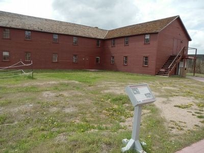
Side A
One of the largest cattle operations in the Wyoming Territory, the Mason-Lovell Ranch moved its headquarters here in 1883. At its peak the ranch grazed cattle from Thermopolis, Wyoming to the Crow Reservation in Montana. . . . — — Map (db m91280) HM
The presence of humans in the Big Horn Basin goes back more than 10,000 years. Evidence suggests that the prehistoric people were nomadic hunters and gatherers. Indians inhabited this area until 1878. In the late 1870s settlers, ranchers, and . . . — — Map (db m88172) HM
The fur industry ruled the northwest at the beginning of the 19th century; however, much of the interior of the western United States remained a mystery. The Lewis and Clark expedition constituted the only organized exploration, a fact which . . . — — Map (db m97954) HM
Gross weight empty 223,276 lbs. Gross weight loaded 563,276 lbs. Engine 16V149 Detroit 1600 hp Life to date: 30,000 hrs. Fuel consumption 20-gal. hr. Tires avg. cost $9,000 Engine rebuild avg. cost $35,000 143 was moved from Butte to the Black . . . — — Map (db m242992) HM
Trivia Question! Where did cattle originate that were trailed to Wyoming? Long-horned cattle were driven up from Texas on the Chisholm, Western and Goodnight Loving Trails. Herefords were shipped from the British Isles and cattle . . . — — Map (db m242990) HM
"The lack of rail service in large areas of Wyoming did not prevent small coal mines from being opened. Throughout much of rural Wyoming wood was not readily available, and it was too valuable to be used as fuel on the plains and basins. Coal . . . — — Map (db m242967) HM
"By mid-century most corporations wished to place themselves at arms length from the "company town" concept, in some cases it was neither possible nor desirable. A need existed. Many employees opposed being on the road for hours; they wanted to be . . . — — Map (db m242991) HM
As with other emigrant trails in the west, the Bozeman Trail followed a route previously used by traders, trappers, and Native Americans. John Bozeman, along with John Jacobs, officially opened the Bozeman Trail to emigrants in 1863. This 500-mile . . . — — Map (db m210594) HM
"In the beginning when Wright was first taking shape and becoming its own place it was the spring of 1949 when the Wyoming Highway Department began constructing the Reno Junction Maintenance Camp. It was located about two and a half miles south of . . . — — Map (db m242956) HM
"In 1886 an explosion killed 2 boys, the territorial legislature took steps to ban children from working in coal mines. The coal mine safety law prohibited boys under the age of 14 and "women and girls of any age" from being employed "in or about . . . — — Map (db m242986) HM
The area near the Wagonhound Rest Area has played an important role in western transportation since the earliest days of human activity in the Rock Mountain west. The area has provided Wyoming's earliest inhabitants, explorers, westbound settlers, . . . — — Map (db m47142) HM
Gateway to the sites of Ghost Towns of the Copper Country. Once a favorite hunting ground of Prehistoric man, later "Camp le Grand" became a noted rendezvous of Indians and trappers. In 1897 the townsite was laid out by Willis George Emerson and . . . — — Map (db m95468) HM
Camped near this spot in 1878,
while on a fishing trip.
It was here that his attention
was directed to the fiber
from his bamboo fishing pole
which he tested as a suitable
filament for his incandescent
electric lamp.
Born February . . . — — Map (db m107499) HM
The hills located to the south and west (your left) are part of the Rawlins Uplift, a 40 mile long, north trending fold in the earth's crust. The geologic feature rises a thousand feet above the surrounding plains. Granite rocks that range in age . . . — — Map (db m95470) HM
The Fort Fred Steele sawmill had traveled thousands of miles by rail and wagon prior to its arrival and installation here, along the North Platte River. The Lane and Bodley 15 horsepower steam-driven sawmill began its journey through the military . . . — — Map (db m89818) HM
Construction of the Union Pacific Railroad stimulated the growth of the timber industry in southern Wyoming. Two companies began supplying ties to the railroad in 1868, but the firm of Coe and Carter was the leading supplier to the Fort Fred Steele . . . — — Map (db m89817) HM
Two cannons located at opposite ends of a meridian island each bear the same inscription.
This cannon of Civil War vintage was for many years an essential part of oil field tank farm equipment. It was used in making holes in a tank . . . — — Map (db m89707) HM
The Post Trader's House was "T" shaped in three sections. The stem of the "T" was built first and over time other rooms were added to the house. The small fireplace was actually designed to burn coal. Many houses of this time period included coal . . . — — Map (db m90004) HM
At age 18, Fenimore Chatterton arrived in Wyoming on September 12, 1878 to begin a lifelong career of service to Wyoming.
The young Fenimore came west on the Union Pacific to Fort Steele for a bookkeeping job at the J.W, Hugus Trading Post. . . . — — Map (db m89995) HM
The cattle industry was also large in the area with some very large cattle companies that owned land in and around the area. One of the largest, the Swan Land & Cattle Co. owned by the Swan Brothers stretched from near present day Scottsbluff, NE to . . . — — Map (db m89970) HM
Sheep ranching came in to the Rawlins & Ft. Steele area in the 1880's with I.C. Miller being one of the earliest. He owned the first flock in 1875. In 1882, about 16 large sheep outfits were listed in the Rawlins area and numbers rapidly grew. . . . — — Map (db m89968) HM
The first authentic sheep wagon was built by James Candlish in Rawlins in 1884 from an idea given him by George Ferris. Caddish, a Canadian blacksmith, followed the Union Pacific construction to Fort Fred Steele and lived there until the troops . . . — — Map (db m89967) HM
Sheep were introduced to Wyoming in the 1850's near Fort Bridger, about 180 miles west of Fort Steele. By 1880 the number had grown to over 350,000 head ranging primarily along the route of the Union Pacific Railroad. The Cosgriff Brothers owned one . . . — — Map (db m89950) HM
The "Good Roads Club" was incorporated in Douglas in 1910 with 119 members and capitalization of $50,000. It was a popular social club with a primary goal to establish a way to improve the road system to enjoy the new automobile.
In 1918, the . . . — — Map (db m92180) HM
Above is an artist’s conception of the interior of the Fort Fetterman version of a “Hog Ranch,” a common frontier term used to describe certain off-post facilities which catered to the lonely soldier’s desire for wine, women and song. A . . . — — Map (db m80093) HM
Erected to the memory of
John Hunton
First President of the
Wyoming Pioneer
Association
Bullwhacker of the 60s
1839 ---- 1928
(Oregon Trail Memorial medallion) — — Map (db m92107) HM
Also known as the Hog Ranch at Fetterman, the One Mile Hog Ranch was perhaps the rowdiest, roughest and most dangerous red light establishment in Wyoming. Built by Harrison Kane in 1880, the saloon sat just across the Platte River, about one mile . . . — — Map (db m80124) HM
The adit, a horizontal entrance (located north of you), was extended into the sandstone cliff face with cut native sandstone blocks. The blocks were capped with large log beams spanned with small diameter ponderosa pine decking and then cover with . . . — — Map (db m98066) HM
The Aladdin Tipple in Crook County, Wyoming, was constructed as part of the Aladdin coal mining operations. In 1898, an 18-mile-long short line known as the Wyoming and Missouri River Railroad was built to connect coal mines near Aladdin with the . . . — — Map (db m34833) HM
Coal Production
The Aladdin Coal Mine began operation in 1898. One of the earliest descriptions of the coal operations at Aladdin is provided by this 1899 Wyoming Coal Mine Inspector report:
Aladdin No. 1 - This mine is situated at . . . — — Map (db m98065) HM
By 1911 the industrial production of coal at the Aladdin Mine was dwindling. Later coal mining at the site was for domestic coal for heating and cooking. The coal was reportedly "a good coal which burned so hot it made the stove top rattle." The . . . — — Map (db m98061) HM
The hoist house (directly west) is a later addition to the coal mine. An internal combustion engine replaced the beasts of burden who originally hauled the coal from within the depths of the hillside. The hoist house is a simple 2 x 4 framed shed . . . — — Map (db m98091) HM
The structure before you is one of the last historic wooden coal tipples left in the west. The wooden tipple structure is an example of mine engineering technology used in the late 1800's and early 1900's. This type of structure is no longer used in . . . — — Map (db m98064) HM
The tilt of the tipple shown in the photos was the result of time and the elements. The degree of tilt and the fact that this structure did not completely collapse is remarkable. The corrosive nature of the coal slack waste piles caused the buried . . . — — Map (db m98063) HM
The enormous task of butchering began immediately after the kill. Adult men and women worked in teams to rapidly skin carcasses and begin cutting them into pieces small enough to be carried out of the sinkhole, possibly by adolescents. Meat . . . — — Map (db m113174) HM
Along this trail passed herds of cattle from distant Texas to replace the fast vanishing buffalo and build a civilization on the north-western plains. — — Map (db m97984) HM
The first Caucasian residents of this area came as prospectors following the Black Hills Gold Rush. In 1876 the glitter of gold led them from the large mining camps of Lead and Deadwood westward to Sand Creek, located near this site. Instead of . . . — — Map (db m45535) HM
Centrally located on the gold-bearing vein in the area, mines literally surrounded Atlantic City by the fall of 1868. The townspeople soon fostered a thriving business community. In addition to sawmills and blacksmith shops, Atlantic City boasted of . . . — — Map (db m80134) HM
Entering Miner’s Delight, you’ll be struck by the mystery and charm of an old west ghost town. The weather, brown logs command as much interest as a clear blue sky are reflected in the glassy surface of the beaver ponds. How do these buildings stay . . . — — Map (db m162424) HM
As the news of gold spread, the Sweetwater Mining District filled with miners who established Hamilton City about two miles east of here in 1867. The following year, the name of the town changed to Miners Delight, after a highly productive nearby . . . — — Map (db m80133) HM
Hacked and Stacked
Ties were made from trees hacked and cut by hand...hence the name "tie hack." Tie hacks were a special breed of loggers who could quickly fell, limb a tree, and fashion the tie down to the specification demanded. . . . — — Map (db m96316) HM
Five hundred yards northwest of this marker stood the Bonneville Cabins, built by Captain B.L.E. Bonneville in 1835 to store his trade goods. Three cabins were constructed and later two more. They were long known as “The Five Cabins, : the . . . — — Map (db m80128) HM
The Historic Mine Trail and Byway Program designated the Gold Flakes to Yellowstone Historic Mine Trail in 2005. This trail links significant finds of gold, iron ore, and uranium, each of which played important roles in Wyoming's history.
The . . . — — Map (db m67009) HM
Home on the range, a tiny community consisting of a post office, gas station, and a few souls, sat quiet and undisturbed along this lonesome stretch of highway until the 1950's. That all changed when the nation's uranium industry boomed after World . . . — — Map (db m67008) HM
Viewed from Beaver Rim, the Wind River Mountains, part of the Rocky Mountain chain, boast 53 granite peaks over 13,000 feet high. The Continental Divide runs the length of the Wind River Range. Water on the east side of the Continental Divide flows . . . — — Map (db m67012) HM
This unique ornate building has been on Lander's Main Street since 1893. Built by Thomas J. Bossert and it was used for his dry goods store. He ran it as a "cash only" store. He advertised clothing at lower prices than every offered in Lander. He . . . — — Map (db m95870) HM
The Fremont served guests for eighty years on the corner of Main and 3rd, from 1891 to 1971. Jerry Sheehan had the foresight to build an out-of-the ordinary hotel in an isolated western town. Mr. Sheehan was no stranger to the hotel business. Prior . . . — — Map (db m95872) HM
The Historic Mine Trail and Byway Program designated the Gold Flakes to Yellowstone Historic Mine Trail in 2005. This trail links significant finds of gold, iron ore, and uranium, each of which played important roles in Wyoming's history.
The . . . — — Map (db m67011) HM
The Historic Mine Trail and Byway Program designated the Gold Flakes to Yellowstone Historic Mine Trail in 2005. This trail links significant finds of gold, iron ore, and uranium, each of which played important roles in Wyoming's history.
The . . . — — Map (db m67015) HM
This building located at 202 Main Street in Lander, WY has weathered over a century of storied & varied history. The building before you was commissioned by, & constructed for, the local International Order of Odd Fellows in 1886. Initially the Odd . . . — — Map (db m131600) HM
In 1886, the social society, the International Order of Odd Fellows, funded the construction of this brick building. The Odd Fellows held their meeting upstairs which was reported as handsomely furnished, and was supplied with “electric . . . — — Map (db m95965) HM
The Lander Hotel was one of the first businesses on Lander’s dusty Main Street. It began as an eating place and stopover for bull-team freighters on their way to Fort Washakie. It was a one-story, four-room log building built by Ben Decora. Later . . . — — Map (db m95961) HM
By 1887-88 the farmers were pushing for a local flour mill and went as far as putting up some of their own money to entice someone to take on the project. At that time, wheat was grown in abundance but little was sold except as chicken feed. J. D. . . . — — Map (db m95967) HM
Major Noyes Baldwin and his wife, Josephine Wright Baldwin, were some of the earliest settlers in the Lander Valley. Before establishing the dry good store in Lander, he had a trading post near Hudson, Wyoming, a log trading post on Baldwin Creek, . . . — — Map (db m95946) HM
J.K. Moore, post trader at Fort Washakie, built the large store shown in mid-photo in the early 1880s. It was later to be one of the most elaborate saloons in the entire west, fitted out with glassware and furniture cut in the shape of diamonds. . . . — — Map (db m95868) HM
The Noble Hotel has been a landmark in downtown Lander since it was built in 1918. The grand hotel was built to serve visitors from the East on their way to Yellowstone. Harold Del Monte bought the hotel in 1929 and set out to recreate the Noble as . . . — — Map (db m95947) HM
This building was the second home to the Noble and Lane Mercantile Business. The face of the mercantile building has changed. It was originally built by Worden P. Noble and Albert D. Lane in 1891. The stone building next to it is where their . . . — — Map (db m95944) HM
In 1891, Eugene Amoretti, successful businessman and one of the “town fathers,” financed the construction of this building. It was the original home of the Palace Pharmacy. The building was large enough to house many different . . . — — Map (db m95970) HM
In 1919 the Sinks Canyon Hydro Electric Company built a power plant in the canyon to provide electricity for Lander. A dam was built upstream of the Sinks. The dam diverted part of the Popo Agie River into a pipeline which carried the water to the . . . — — Map (db m95820) HM
In 1842, gold was first found in the Wind River Mountains of Wyoming by a fur trapper, Georgia Tom Mckeever of the American Fur Company. Mckeever passed before he could get his gold to an assayer, leaving location unknown. Given the hostile . . . — — Map (db m152989) HM
The hills of the Sweetwater Mining District hold various minerals, and beginning in the 1960s, iron ore mining provided an economic boom for the area. In 1960 the U.S. Steel Corporation broke ground on the nation's highest open pit iron ore mine at . . . — — Map (db m67014) HM
The demand for beaver pelts in the early 1800s led to the exploration and eventual settlement of the American West. South Pass was part of a major thoroughfare through the Rockies and its discovery is significant to the era known as the fur trade. . . . — — Map (db m67022) HM
In memory
of the Trappers, Traders
and Explorers, who
established the Rendezvous
at the Junction of the
Little and Big Wind Rivers — — Map (db m80127) HM
Boysen Dam, completed in 1951, marks the southern margin of the east-west trending Owl Creek Mountains and the Wind River Canyon. Drained by the north flowing Wind River, the canyon is 14 miles long, 1.3-2 miles wide and 2,400 feet deep where it . . . — — Map (db m70611) HM
An arrastra is a type of primitive mill used to crush ore and extract gold and silver. Water diverted from Willow Creek turned the large water wheel to provide power. A drive shaft connected to the wheel rotated a series of cogwheels that in turn . . . — — Map (db m154156) HM
As early as 300 BC, the Greeks use the primary components of a stamp mill - drive wheel, cams, and stamps - for pounding and hauling grain. The concept was adapted to crushing ore and became widely used in America as a gold recovery process.
. . . — — Map (db m154146) HM
Thousands rushed to the South Pass area following the find of substantial gold deposits at the Carissa Mine in 1867. As the boom gained steam, the Carissa sat at the center of mining development, serving as the primary economic force for South Pass . . . — — Map (db m80146) HM
. . . the articles of trade consist, on the one side, almost entirely of buffalo robes; and, on the other, of blankets, calicoes, guns, powder, and lead, [and] . . . cheap ornaments such as glass beads, looking-glasses, rings, vermillion for . . . — — Map (db m86968) HM
In 1834, Robert Campbell and William Sublette established the first fort at the confluence of the North Platte and Laramie Rivers. Christened Fort William, the post was rectangular, measuring only 100 by 80 feet. Hewn cottonwood logs 15 feet high . . . — — Map (db m86958) HM
With reddened knuckles and rolled up sleeves, an obscure corps served the 19th century army. Beginning in 1802, the army enlisted women aged 13 and older to wash soldiers’ laundry. Laundresses received a wage, quarters, fuel, rations, and medical . . . — — Map (db m86993) HM
The Rustic Hotel opened in 1876. During that year it probably provided the best accommodations for travelers between Cheyenne and the Black Hills. It also served as a station for the Cheyenne-Black Hills Stage and Express Line. By 1883, when this . . . — — Map (db m71020) HM
In remembrance of the hardy pioneer stockmen and cowboys who drove their Texas herds across this spot into central and northern Wyoming — — Map (db m98347) HM
Over this trail, from distant Texas, passed the greatest migration of men and cattle in the history of America.
(second plaque at the base:)
In Memory
of the pioneer cattlemen who passed this way on the Old Texas Trail . . . — — Map (db m98349) HM
Following the Lewis and Clark Expedition, much of the interior of the western United States remained a mystery and most people traveling to the west coast went by ship. By 1811, at the height of the fur trade, John Jacob Astor, owner of the Pacific . . . — — Map (db m79700) HM
1869 - Occidental Hotel established as a tent in its present location alongside Clear Creek
1879 - First buildings constructed in what is now Buffalo
- Postal service established in Buffalo by President Hayes . . . — — Map (db m244120) HM
The National Register of Historic Places Wyoming Place No. 176 Downtown Historic DistrictHistoric Hotels of America National Trust for Historic Preservation — — Map (db m45546) HM
There are six plaques on this rather large monument. Prehistoric Cheyenne
Those First to Life Here
There is evidence of prehistoric man living in Wyoming more than 12,000 years ago before present (YBP). These early . . . — — Map (db m96408) HM
Cheyenne was founded in 1867 as a terminal for the Union Pacific's transcontinental railway through southern Wyoming. The city grew bigger and faster than most rail towns, in part due to nearby U.S. Army Fort D.A. Russell, established in 1867, and a . . . — — Map (db m92203) HM
With the coming of the transcontinental railroad and with settlers and ranchers moving into the greater Cheyenne area, it was quickly apparent that 180 acre land grants were insufficient to sustain a livelihood. Shrewd businessmen, many foreign born . . . — — Map (db m95210) HM
The Cattle Trails
The cattle drives and the trails that they followed were designed to move large numbers of Texas and Mexican cattle to Cheyenne to meet the railroad or further north into Montana for summer grazing. The trails were . . . — — Map (db m113831) HM
Here in Sept. 1812, the returning Astorians led by Robert Stuart were attacked by the Indians and their horses stolen.
Dedicated July 4, 1939, to commemorate the opening of the Snake River Canyon Road.
Built by Civilian Conservation Corps. . . . — — Map (db m90550) HM
Beginning in 1843, emigrants traveled across the continent along what became known as the Oregon Trail. Increased traffic during the 1850's resulted in the first government road construction project in the west. The 345 mile Central Division of the . . . — — Map (db m90521) HM
Throughout history, humans have followed river banks in search of resources to support commerce. Rivers made possible the exploration and mapping of North America. Major waterways served as trade routes for native peoples, corridors for European . . . — — Map (db m91949) HM
Permanent settlers began claiming this region by the late 1870s, at the end of the Plains Indian wars. The nearby Goose Egg Ranch dates to 1877 when the Searight Brothers Cattle Company trailed more than 20,000 head of cattle into Wyoming Territory. . . . — — Map (db m91979) HM
Drilling rigs of this type were used from about 1878 into the 1950's. With the drilling of deeper wells, starting in the 1920's, cable-tool drilling was gradually replaced by more modern rotary-drilling methods. This replica was built using plans . . . — — Map (db m95586) HM
middle panel:
Shaped by History
Salt Creek oil brought prosperity to Casper, in addition to people and industry. Despite the closure of Casper refineries as well as reduced output of Salt Creek oil in recent years, oil history . . . — — Map (db m92055) HM
The Goose Egg Ranch first received some notoriety when Owen Wister featured it in his book, The Virginian. In the novel, this is where the cowboys exchanged the babies’ blankets, and after the dance, the mothers carried home the wrong . . . — — Map (db m164524) HM
Two plaques and a medallion are located at this site:
Oregon- California Trail
During the years 1841-1867 over 350,000 persons passed through Casper on their way West. The majority of them traveled through what is now the lobby . . . — — Map (db m92022) HM
From Wyoming's very beginnings and with the completion of the first transcontinental railroad, the livestock industry was anticipated to secure a viable ecumenic base for the new territory. Most of the territory consisted of rangeland where buffalo . . . — — Map (db m164522) HM
The famous Salt Creek oil field is located in Natrona County, 40 miles north of Casper. Representative Stephen W. Downey was the first man to acquire land at Salt Creek in 1883, after the discovery of the Jackass Spring oil seep. The discovery oil . . . — — Map (db m164528) HM
Native Americans were the first to use Wyoming's oil and later show early explorers where to find it. Sticky black liquids bubbling in natural seeps were used for liniments and paints. In 1832, Captain Bonneville found the "great tar spring' below . . . — — Map (db m95587) HM
(top panel:)
Some Salt Creek oil wells in the 1910s-20s were uncontrollable gushers. Before pipelines, storage tanks, and advanced equipment, much oil soaked into the ground, ran into streams, and was burned to reduce runoff. A few . . . — — Map (db m95636) HM
“Get out and don’t come back!” was the message John Hunton and his oil prospecting party received in 1873 from a mounted band of Arapahoe Indians while filling glass jars with pure crude oil seeping from the sandy ground. This is the . . . — — Map (db m95627) HM
Stockmen were aware of pools of oil in the creek bottoms during cattle trailing days. These oil seeps led to the discovery of Salt Creek, one of Wyoming’s largest oil fields, nine miles long by five miles wide.
In 1883, the first claims were . . . — — Map (db m91657) HM
Stockmen were aware of pools of oil in the creek bottoms during cattle trailing days. These oil seeps led to the discovery of Salt Creek, one of Wyoming's largest oil fields, nine miles long by five miles wide. In 1883, the first claims were filed . . . — — Map (db m95626) HM
184 entries matched your criteria. The first 100 are listed above. The final 84 ⊳