Dickison and His Men
John Jackson Dickison (1816-1902), Florida's famous Civil War guerrilla leader, bivouacked at Camp Baker, south of here, during the closing weeks of the conflict. Dickison and his men became legendary figures. As Company . . . — — Map (db m40315) HM
On North Jefferson Street south of West 4th Street, on the left when traveling north.
The Jefferson Street Pool was the first major municipal facility of its kind available to African Americans in Jacksonville. Prior to its establishment in 1951, a few community pools for black people had been created.
The Jefferson Street Pool . . . — — Map (db m237299) HM
Near Halsema Road North, 0.4 miles north of Old Plank Road, on the right when traveling north.
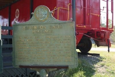
Jefferson Davis led a fascinating life as a politician who fought to establish the Confederate States of America. After being wounded during the Mexican-American War, Davis served the state of Mississippi in the U.S. Congress 1835 to 1861. When . . . — — Map (db m142728) HM
On North Highland Avenue south of West Gladys Street, on the left when traveling north.
The oldest high school building standing today in Hillsborough County is located at 2704 Highland Avenue in Tampa. It was designed by Wilson Potter of New York. The cornerstone reads HILLSBOROUGH COUNTY HIGH SCHOOL, but when it opened on October 12, . . . — — Map (db m32380) HM
On Groover Road (County Road 6) at Rains Road, on the right when traveling north on Groover Road. Reported missing.
The Elizabeth School, a three-room, vernacular shingle-clad building, was a school for Black students on Groover Road in 1938 and was funded by parents and the Works Progress Administration (WPA). Miles Edward Groover (1887-1966) and his wife, Daisy . . . — — Map (db m67601) HM
On 2nd Street at Park Avenue, on the right when traveling east on 2nd Street.
This historic marker recognizes Howard Academy Elementary/Junior High School, which eventually became Howard Academy High School. In 1957, the first phase of Howard Academy Elementary and Junior High School was constructed on Second Street. The . . . — — Map (db m67639) HM
On Mamie Scott Drive north of Cypress Street, on the left when traveling north.
Howard Academy High School's Building 1 opened on Chestnut Street in 1936 with one structure containing several classrooms. In 1940, a similar, second building was constructed and financed by the county, parents and The Julius Rosenwald Fund. . . . — — Map (db m67656) HM
On Jefferson Street (Courthouse Circle) (U.S. 19) at Washington Street (U.S. 90), on the left when traveling north on Jefferson Street (Courthouse Circle).
(front/north side)
Erected 1899 by the Ladies’ Memorial
Association of Jefferson County Fla.
Our Fallen Heros
(west side)
Let this testimonial of Woman’s deathless fidelity to Man’s imperishable valor speak to the sons . . . — — Map (db m126495) WM
On West Washington Street (Florida Route 10) at South Water Street, on the left when traveling west on West Washington Street.
Jefferson County High School
Erected 1852
Charter Granted in 1852 by Legislative Council
First brick school building constructed in state
Bricks made on George Taylor Plantation
Building constructed by Samuel Carroll with slave . . . — — Map (db m239585) HM
On Jefferson Street (Courthouse Circle) (U.S. 19) at Washington Street (U.S. 90), on the left when traveling north on Jefferson Street (Courthouse Circle).
When Florida’s Territorial Legislative Council established Jefferson County in January, 1827, settlers from the seaboard states already had begun to develop cotton plantations in this area. In December, 1827, the county seat received the name . . . — — Map (db m126297) HM
On North Jefferson Street (U.S. 19) south of West Pearl Street, on the right when traveling south.
Jefferson County became Territorial Florida's 13th county in January, 1827. In December of that year, the town of Monticello, named in honor of Thomas Jefferson's famous Virginia home, was laid out and lots began to be sold. During the 1830s and . . . — — Map (db m126300) HM
On South Bronough Street, 0.1 miles south of West Pensacola Avenue, on the right when traveling south.
Jefferson County
“The willingness with which our young people
are likely to serve
in any war, no matter how justified,
shall be directly proportional
as to how they perceive
the veterans of earlier wars
were treated . . . — — Map (db m210470) WM
In 1873 Fort Jefferson's armament was modernized to include six 15-inch Rodman smoothbore cannon and four 300-pounder rifled Parrott guns. Of the 141 guns listed at the fort when the garrison left in 1874, only those 10 remain here today. The other . . . — — Map (db m193412) HM
Other than bread, fish, shrimp, and turtles, most of the food—salted pork, salted beef, and beans—came from the mainland. Officers fared better than the soldiers and prisoners. "The bread was a mixture of flour, bugs, sticks and dirt," Lincoln . . . — — Map (db m248002) HM
After the USS Maine battleship was sunk in Havana, Cuba, in February 1898, the US military strengthened its operations in the Gulf of Mexico and Caribbean to protect strategically important shipping lanes. This concrete pad is all that . . . — — Map (db m225119) HM
What do you do if enemy troops land on the beach and start across the moat? Catch them in a crossfire from howitzers in the bastions, which extend outward from the fort's six exterior walls. Howitzers could fire canisters that spewed golf ball-sized . . . — — Map (db m243920) HM
Look around you. From this vantage point, the sea seems to go on forever. Fort Jefferson appears to be in the middle of nowhere. But it is really at the gateway to some out-of-sight landmasses. To the south, 106 miles away, is Cuba. To the east, 68 . . . — — Map (db m225074) HM
The Dry Tortugas keys sit at the crossroads of biologically rich sea currents, migratory bird routes, and strategic shipping lanes that link the eastern United States with Gulf Coast ports like New Orleans, Mobile, and Pensacola. From tiny coral . . . — — Map (db m226169) HM
Fort Jefferson, the largest all-masonry fort in the United States, was built between 1846 and 1875 to protect the nation's gateway to the Gulf of Mexico. Supply and subsidence problems and the Civil War delayed construction. Sections of the fort . . . — — Map (db m225108) HM
The 8- and 10-inch columbiads were standard U.S. cannon for coast defense. They were cast-iron, muzzle-loading smoothbores. The 8-inch weighed 9,210 pounds and when elevated 4” threw a 65-pound ball about a mile. From the top of the fort, the . . . — — Map (db m100238) HM
National Park Service rangers, researchers, maintenance workers, and their families live here year-round. Most of them live in small apartments built within the fort's casemates and have their own kitchen, bedrooms, living room, and bathroom. Staff . . . — — Map (db m240103) HM
Near Wall Street at Tift’s Aly, on the left when traveling north.
Jefferson Browne attended school in Key West but graduated from Kenmore University High School in Amherst, Virginia, in the mid 1870’s. He became a lighthouse keeper, at Fowey Rocks Lighthouse for fifteen months where he spent his spare time . . . — — Map (db m222934) HM
A fort's effectiveness in the 1800s depended in large part on its gunpowder supply. Keeping the powder dry and avoiding explosions were critical. This powder magazine's special features included wooden floors and walls to prevent sparks, and vents . . . — — Map (db m193408) HM
The Dry Tortugas offer a sheltered harbor for ships, but their reefs and shoals have claimed more than 200 wrecks since the 1500s. To warn mariners, the US government built a 70-foot lighthouse in 1825—26 on Garden Key 20 years before work started . . . — — Map (db m225093) HM WM
In 1898, the U.S. battleship Maine sailed from this anchorage to her destruction in La Habana harbor. “Remember the Maine” became the rallying cry for the Spanish-American War that followed. The anchorage served the navy through . . . — — Map (db m100241) HM
This vantage point atop Bastion A provides a sweeping view of Fort Jefferson’s parade ground and major historic features.
Traverse Magazine • Harbor Light • Sally Port (exit) • Rodman Cannon
Large Detached Magazine • Soldier’s . . . — — Map (db m225114) WM
Imagine what it was like to heat solid cannonballs in a hot shot furnace like this one, so gun crews could fire red-hot projectiles at wooden warships to set them ablaze. This process involved several soldiers. One soldier maintained the coal fire . . . — — Map (db m193410) HM
The 300-pounder Parrot had spiral grooves, called rifling, which caused its elongated, pointed projectile to spin. This made the Parrotts much more accurate than smoothbore Rodman cannon that fired round cannonballs. The Parrot's muzzle-loaded . . . — — Map (db m225067) HM
The fort was not built as a prison, and it has no dungeons. But prison it became, and at times "hard cases" were clapped into magazines or secure gunrooms.
One man who knew this room was Dr. Samuel Mudd. He was shackled in irons after trying to . . . — — Map (db m246656) HM
Two large, unplastered first and second floor rooms at the north end of the barracks served as post hospital. There was also a makeshift isolation facility on Hospital Key, almost two miles away.
Though Fort Jefferson was considered a healthful . . . — — Map (db m225084) HM
It protected the fort walls from (1) heavy seas, and (2) enemy landings.
Most of the moat wall was built in 1849-1851, but digging the moat to full depth, a task for prisoners, was not completed until 1873.
Beginning in 1861, dozens of . . . — — Map (db m225073) HM
A self-guiding, easy-to-moderate tour of the fort's three levels takes about 40 minutes. Use this diagram to devise your own route. As you walk, think about the construction obstacles that confronted the US Army Corps of Engineers—shifting sands, . . . — — Map (db m240094) HM
These hill-like structures on the terreplein protected ammunition from enemy fire. They also could shield nearby gun crews if necessary. Sixteen traverse magazines are located between gun platforms on the open—and thus vulnerable—top tier of the . . . — — Map (db m225097) HM
Fort engineers designed an innovative system to collect and store rainwater to provide fresh water for the islands 1500 planned residents.
Garden Key receives about 30 inches of rain a year. Rain falling on the fort's top tier filtered down . . . — — Map (db m193731) HM
Near Marine Street north of San Salvador Street, on the left when traveling north.
This garden is a living tribute to all
of America's veterans and their
families. In silence and respect, this is
a place to remember why millions of
Americans have fought and died for
our liberty and our freedom.
Here we renew our . . . — — Map (db m220157) WM
On Bridge Street at Martin Luther King, Jr. Avenue, on the right when traveling west on Bridge Street.
Original Homesite of
Maria Jefferson Epps Shine
Great Granddaughter of Thomas Jefferson
Founder of the Local Chapter
of the National Society
Daughters of the American Revolution
and held the organizational meeting here
at 102 . . . — — Map (db m241190) HM
Near Cemetery Street, 0.2 miles east of East Campus Road.
Lt. Col. Jefferson Mirabeau Lamar commanded Cobb’s Legion Infantry at Crampton’s Gap. Lamar graduated from the University of Mississippi before opening a law practice in Covington, GA. A month after his July 1861 marriage to his cousin, Mary Ann . . . — — Map (db m108759) HM
On West Central Avenue (U.S. 319) at Grant Street (U.S. 129), in the median on West Central Avenue.
On May 4, 1865, Jefferson Davis arrived in Washington, Georgia (178 miles NE of the Park), where he performed his last duties as President of the Confederate States of America. Shortly thereafter, with a small staff and escort, he departed enroute . . . — — Map (db m40378) HM
On Georgia Avenue at Bond Street, on the right when traveling west on Georgia Avenue.
Here ex-president Jefferson Davis, Mrs. Davis and their two daughters Mrs. Margaret Hayes and Varina Ann (Winnie) Davis were the house guests of Capt. and Mrs. Joseph Marshall Johnston from Oct. 24 to Nov.2, 1887, coming to attend the Confederate . . . — — Map (db m186638) HM
On Mulberry Street, 0 miles east of 2nd Street, in the median.
On May 4, 1865, Jefferson Davis arrived in Washington, Georgia (100 miles NE), where he performed what proved to be his last duties as President of the Confederate States of America. Shortly thereafter, with a small staff and escort, he departed . . . — — Map (db m25409) HM
On Willie Smokie Glover Drive east of Riverside Drive, on the left when traveling east.
While in the city to attend a reunion
of Confederate veterans, Jefferson Davis, ex-president of the Confederate States
of America, addressed the veterans from
this speakers stand on Wednesday, October 26, 1887. On the following Saturday, Mr. . . . — — Map (db m236924) HM
Near Bull Street at Taylor Street, on the left when traveling north.
Jefferson Davis, former President of the Confederate States of America, was a guest in 1886 in the house on the northeast corner of Bull and Taylor Streets. The residence (built about 1880) was at that time the home of Hugh M. Comer, President of . . . — — Map (db m5983) HM
On Oak Street (U.S. 23) at Sixth Avenue, on the right when traveling east on Oak Street.
On May 4, 1865, Jefferson Davis arrived in Washington, Georgia (132 miles NE, where he performed what proved to be his last duties as President of the Confederate States of America. Shortly thereafter, with a small staff and escort, he departed . . . — — Map (db m57175) HM
Jefferson Davis
President of the Confederate States of America 1861-1865 Reverse: On this spot May 10, 1865 President Jefferson Davis was made a prisoner of war by Federal troops Erected by the State of Georgia Eugene Talmadge, . . . — — Map (db m10568) HM
On May 4, 1865, Jefferson Davis arrived in Washington, Georgia (178 miles NE), where he performed his last duties as President of the Confederate States of America. Soon thereafter, with a small staff and escort, he departed enroute to the . . . — — Map (db m10569) HM
Late on May 8th, the night before his arrival at this site, Mr. Davis and his party had camped in Abbeville (26 miles NE), unaware that pursuit was close behind. Their pursuers, the 1st Wisconsin Cavalry (US), Lt. Col. Henry Harnden, had learned . . . — — Map (db m40151) HM
On Irwinville Highway (Georgia Route 32) at Jeff Davis Park Road, on the right when traveling west on Irwinville Highway.
On the night of May 9, 1865, Jefferson Davis, with his family and a small escort, enroute south to avoid a screen of Union cavalry attempting to intercept him, reached the site of the present Jefferson Davis Memorial State Park (1 mile north) and . . . — — Map (db m40345) HM
On Mystic Highway (Georgia Route 32) at Tifton Highway (Georgia Route 35), on the right when traveling west on Mystic Highway.
On May 4, 1865, Jefferson Davis arrived in Washington, Georgia (178 miles NE of the Park), where he performed his last duties as President of the Confederate States of America. Shortly thereafter, with a small staff and escort, he departed enroute . . . — — Map (db m164830) HM
On Sycamore Street (Georgia Route 15/82) at East Public Square, on the right when traveling east on Sycamore Street.
(front)
Dedicated to the valor of Jackson County Troops that served the Confederate States of America
In 2008 the City of Jefferson and Historic Preservation Commission approved the replacement of the CSA Statue broken in 1940 . . . — — Map (db m182638) WM
On South Tallahassee Street (U.S. 23/221) at Jeff Davis Street, on the left when traveling south on South Tallahassee Street.
Jefferson Davis
[Confederate States of America Seal]
President
Confederate States of America
1861
(West face) Presented to Preserve the
Memory of the sacrifices of
the people of the South
as exemplified by our . . . — — Map (db m22204) HM
On Central Drive (U.S. 80) 0.1 miles west of Nobles Drive, on the right when traveling east.
On May 4, 1865, Jefferson Davis arrived in Washington, Georgia (102 miles N), where he performed what proved to be his last duties as President of the Confederate States of America. Shortly thereafter, with a small staff and escort, he departed . . . — — Map (db m49509) HM
On Central Drive (U.S. 80) 0.1 miles west of Nobles Drive, on the left when traveling east.
On May 7, 1865, Jefferson Davis, with his family and a small escort, passed through Dublin enroute south to avoid a screen of Union cavalry attempting to intercept him. That evening, the 1st Wisconsin Cavalry [US] reached Dublin and camped at the . . . — — Map (db m49511) HM
On Georgia Route 118 at South Stanton Drive (U.S. 41), on the right when traveling east on State Route 118.
Early in May, 1865, Federal cavalry under command of Col. R.H.G. Minty, U.S.A., passed through Smithville in pursuit of Jefferson Davis. They camped for one night near this spot, moved west to Cuthbert, then to Eufaula, Ala., south to Fort Gaines, . . . — — Map (db m40013) HM
Jefferson Davis
West Point Graduate
Class of 1828
* * *
Services:
Indian Wars 1829- 1835
Member of Congress 1845-'46
Colonel U.S. Army
Hero of Buena Vista and Monterey
Secretary of War 1853-'57
Senator from Mississippi . . . — — Map (db m9645) HM
On Laney Walker Boulevard at 13th Street, on the right when traveling west on Laney Walker Boulevard.
Born in Ruckerville, Ga., he moved to Augusta
in 1842. He organized Springfield Baptist
Church's first Sunday School, served as president of
the Colored Baptist Sunday School Convention, founded
Harmony Baptist Church in 1868, and served as . . . — — Map (db m227178) HM
On Love Avenue (U.S. 41) at West 12th Street (Georgia Route 125), on the right when traveling north on Love Avenue.
On May 4, 1865, Jefferson Davis arrived in Washington, Georgia (178 miles NE of the Park), where he performed his last duties as President of the Confederate States of America. Shortly thereafter, with a small staff and escort, he departed enroute . . . — — Map (db m39992) HM
On Georgia Route 57 at Georgia Route 68, on the right when traveling west on State Route 57.
On May 4, 1865, Jefferson Davis arrived in Washington, Georgia (85 miles N), where he performed what proved to be his last duties as President of the Confederate States of America. Shortly thereafter, with a small staff and escort, he departed . . . — — Map (db m41411) HM
On South Harris Street (Georgia Route 15) 0 miles south of Newman Street, on the left when traveling south.
On May 4, 1865, Jefferson Davis arrived in Washington, Georgia (68 miles N), where he performed what proved to be his last duties as President of the Confederate States of America. Shortly thereafter, with a small staff and escort, he departed . . . — — Map (db m24785) HM
On Warthen Road (Georgia Route 15) 0.2 miles north of Bay Springs Road.
Jefferson Davis, President of the Confederate States of America and party camped near here in a wooded area, when trying to reach Mobile, in his flight from Federal Soldiers. The party, on horseback, stopped at Warthen’s Store to purchase food . . . — — Map (db m24361) HM
On North Broad Street (U.S. 129) at Park Avenue, on the right when traveling south on North Broad Street.
On May 4, 1865, Jefferson Davis arrived in Washington, Georgia (152 miles NE), where he performed what proved to be his last duties as President of the Confederate States of America. Shortly thereafter, with a small staff and escort, he departed . . . — — Map (db m40086) HM
On North Broad Street (U.S. 129) at West Main Street (U.S. 280), on the right when traveling south on North Broad Street.
Late on May 8, 1865, Jefferson Davis, with his family and a small escort, camped in Abbeville, unaware that hostile pursuit was close behind. His pursuers, the 1st Wisconsin Cavalry [US], Lt. Col. Henry Harnden, arrived next morning, shortly after . . . — — Map (db m40087) HM
On East Main Street (U.S. 280) at North Broad Street (U.S. 129), on the right when traveling west on East Main Street.
Erected June 3, 1925 by Abbeville Daughters of the Confederacy to dedicate the spot where Jefferson Davis our great Confederate leader camped May the 9th 1865 the night before his capture. Love makes memory eternal. "Lest we forget." — — Map (db m164768) HM WM
On East Court Street at East Square, on the right when traveling west on East Court Street.
On May 4, 1865, Jefferson Davis arrived in Washington where he performed what proved to be his last duties as President of the Confederate States of America. Shortly thereafter, with a small staff and escort, he departed enroute to the . . . — — Map (db m25541) HM
Near East Lake Forest Drive near Orchid Way, on the right when traveling west.
Along this historic trail, from 1841 to 1861, traveled the greatest land migration in history. Nearly half a million pioneers came to settle America's Northwest. One out of every eight would perish along the way. — — Map (db m125859) HM
On State Highway 91, on the right when traveling north.
Charles Jefferson Hunt served in the Mormon Battalion as Captain of Company “A” and as assistant executive officer. In its historic march from Council Bluffs, Iowa to San Diego, California, 1846 - 47. His service won the commendation of . . . — — Map (db m48986) HM
On Memorial Drive at Riverside Drive, on the left when traveling north on Memorial Drive.
The fertile soil and abundance of water in this
valley lured pioneer settlers. With small slip
scrapers, hand plows, picks and shovels, they
cleared sagebrush, built log homes, made canals,
ditches and dams to put water on the land. One of . . . — — Map (db m239843) HM
On East 480 North near North 3450 East, on the left when traveling west.
In 1882, Richard F. Jardine, Edmund, Brigham, and John Ellsworth with their families founded Lewisville. It was named in honor of Lewis and Clark Expedition and was one of the first settlements in the Snake River Valley. They cleared sagebrush, dug . . . — — Map (db m124483) HM
On West 1st South (State Highway 48) at Church Street, on the right when traveling east on West 1st South.
Bybee-Centerville, also known as Sayer, was located between Lewisville and Rigby, the Drybed Channel of the Snake River (Great Feeder Canal) and the Burgess Canal. It was settled 1883-84 by John A. Cuthbert, Alexander Kinghorn, Dan Adams, William . . . — — Map (db m140582) HM
On Centennial Lane near South State Street (Business U.S. 20), on the left when traveling south.
In 1884 a group of Utah Mormons settled and pioneered this locality. The cleared sagebrush land, dug canals and erected humble log homes. The built a log room which was used for church, school and recreation. Daniel S. Robbins, a veteran, was made . . . — — Map (db m124386) HM
On North Milwaukee Avenue at West Higgins Avenue, on the left when traveling north on North Milwaukee Avenue.
[Etched around the top of the memorial:]
In memory of all the men and women of this community who served in World War II
[Plaques affixed to the side of the memorial:]
A memorial to all that gave their lives in World War 1
A memorial to . . . — — Map (db m248246) WM
On 14th Street north of Main Street, on the left when traveling north.
This building was constructed for the Southern Division of the Illinois Supreme Court, one of three divisions created by the Constitution of 1848. Court met in lodge halls in Mount Vernon prior to completion of the center section of this building . . . — — Map (db m61702) HM
On North 27th Street, 1 mile Caroline St., on the left when traveling north.
Replica of the James Thomas Johnson General Store originally located in the 600 block of Opdyke Street (present day location of the old Mt. Vernon Township High School football field). The store was constructed in the latter half of the 19th century . . . — — Map (db m239484) HM
On North 27th Street, 0.1 miles south of Highland View, on the right when traveling south.
The Goshen Road was one of the main arteries of travel in the early 1800's, when Illinois was frontier country. The road ran in a Northwesterly direction from Shawneetown to Edwardsville - A distance of more than 150 miles. Shawneetown and . . . — — Map (db m88993) HM
On Aviation Drive north of New Fairfield Road (Illinois Route 15).
These loved ones gave their tomorrows so that we could have our todays
World War I
Arnold, Robert E. • Blankenship, Fred • Bond, Roy • Borden, Clyde • Foster, Floyd A. • Fred, Gale • Glasebrook, Harlay • Glenn, Harry • Gowler, Samuel . . . — — Map (db m212636) WM
On North 7th Street at Jefferson Street (Illinois Route 97), on the right when traveling south on North 7th Street.
On August 14, 1908, a mob gathered at the Sangamon County Jail and demanded the release of George Richardson and Joe James, two black prisoners. Richardson was accused of raping Mabel Hallam, a white woman; and James was accused of the murder of . . . — — Map (db m199935) HM
On East Chestnut Street at Spring Street, on the right when traveling east on East Chestnut Street.
Street celebrations and parades were very common in the past and much better attended than some are today. In the picture of what is now Red Yeti, you will notice that the crowd has assembled in front of an Army Surplus store. Post World War II, . . . — — Map (db m206921) HM
On West Market Street at Spring Street, on the right when traveling west on West Market Street. Reported unreadable.
This Italianate style building had multiple uses. The first floor was the bank and the second floor was office space and meeting rooms. It had a basement with access on the south side and, in the 1890s, the Lyon family was walking here when they . . . — — Map (db m206922) HM
On East Court Avenue at Spring Street, on the left when traveling east on East Court Avenue.
Jeffersonville is named for President Thomas Jefferson, who had a profound influence on the city. As a Virginia legislator, Jefferson was a strong supporter of General George Rogers Clark's Illinois campaign from 1778 to 1779, which resulted in the . . . — — Map (db m241638) HM
On East Court Avenue at Spring Street, on the right when traveling west on East Court Avenue.
Thomas Jefferson was born on April 13, 1743 in Shadwell, Virginia. He was a draftsman of the U.S. Declaration of Independence; the nation's first secretary of state (1789-94); second vice president (1797-1801); and as the third president . . . — — Map (db m245086) HM
On U.S. 31 north of Ebenezer Church Road, on the left when traveling north.
Was born in Clark Co., Ind. Appointed colonel of the 22nd Indiana Infantry. After promotion to brigadier general for service at Pea Ridge, he saw action at Corinth, Murfreesboro, and Chickamauga and the Atlantic Campaign. — — Map (db m161455) HM
On North Jefferson Street at East Washington on North Jefferson Street.
(Side 1)
Canal Landing on Washington Street. The Huntington Landing started 120 feet west on Washington St and continued to the lock at Cherry St. The Wabash & Erie canal was 4 feet deep and 100 feet wide as this point. Other locks . . . — — Map (db m65223) HM
On Cragmont Street north of Presbyterian Avenue, on the right when traveling north.
Born in Madison 1839. Family home on West Main Street. Attended Hanover College 1856-1858 to pursue practice of law. Attended Kentucky Military Institute in Frankfort. Organized Madison City Greys 1858, which became part of Sixth Regiment Indiana . . . — — Map (db m206804) HM
On Ohio River Scenic Byway (State Road 56) at South Eagle Hollow Road, on the right when traveling west on Ohio River Scenic Byway.
Harris, a free African American, came to Madison, 1839, as the fight over slavery along the Ohio River became more violent. He worked as a teamster, farmer, and Baptist minister. His family owned land in Eagle Hollow and Madison. Harris's activities . . . — — Map (db m206771) HM
On West Vaughn Drive just east of Central Avenue, on the right when traveling east.
The completion of Madison's railroad connection to Indianapolis in 1847, the first in the state, heralded the peak of Madison's golden years as a manufacturing city, shipping port, and busy river town. Since the early 1800s, Madison had continued . . . — — Map (db m180813) HM
On East Main Street (Ohio River Scenic Byway) (U.S. 421) just east of Jefferson Street (U.S. 421), on the right when traveling west.
Jefferson County Courthouse [west side]Completed in 1855, the Greek Revival style brick and stone courthouse replaced a smaller octagon shaped courthouse that burned in 1853. In 1869 the roof was rebuilt with the steeper pitch . . . — — Map (db m181158) HM
On East Main Street (U.S. 421) at Jefferson Street, on the right when traveling east on East Main Street.
Dedicated to the memory of these fallen comrades who in answering the call to arms, paid the price of freedom
Korea Charles S. Branch • Glenn L. Con • Marcus L. Harmon • Robert E. McGee • Wendell W. Marshall • Clarence Reed • Alvin . . . — — Map (db m243071) WM
On East Main Street east of Jefferson Street, on the right when traveling east. Reported permanently removed.
(Middle Panel - Top)
Dedicated
To the memory of these Fallen Comrades
who, in answering the call to arms,
paid the Price of Freedom.
(Left Panel)
World War I
Harrison B. Buckner • William Buckner • . . . — — Map (db m241840) WM
On West 1st Street just west of Vine Street, on the left when traveling west.
One of Madison’s most prominent citizens was James Franklin Doughty Lanier. He was a pioneer and respected banker/financier. Lanier hired the talented architect Francis Costigan to design his magnificent mansion on the Ohio River, where it shines . . . — — Map (db m180800) HM
On West Main Street at McIntire Street, on the right when traveling west on West Main Street.
Built 1836-1841 as part of Indiana's 1836 Internal Improvement Act. Measures 7,012 feet long and elevates 413 feet to achieve a 5.89 percent grade; 500, 000 tons of rock and earth were moved in construction. Still considered to be the steepest . . . — — Map (db m206805) HM
Near Jefferson Street south of East Main Street (Ohio Scenic River Byway) (U.S. 421), on the left when traveling south.
This bell, which once hung in the Courthouse cupola, survived the Courthouse fire of May 20, 2009 thanks to the efforts of 18 area volunteer fire departments. According to the inscriptions of its exterior, the bell was cast by the G.W. Coffin & . . . — — Map (db m181496) HM
On East Main Street east of Jefferson Street, on the right when traveling east. Reported permanently removed.
In Honor of A Native Son
Samuel Woodfill
Major, United States Army
——————
Born near Bryantsburg, Indiana
June 6, 1887
Died Vevay, Indiana
August 10, 1951
Buried in Arlington Naational Cemetery
——————
"The . . . — — Map (db m241841) WM
On East Main Street, on the right when traveling east.
In honor of a native son
Samuel Woodfill
Major, United States Army
born near Bryantsburg, Indiana
January 6, 1883
Died Vevay, Indiana
August 10, 1951
Buried in Arlington National
Cemetery
"The outstanding American soldier
in . . . — — Map (db m242693) HM WM
On County Road N 300W, 0.1 miles north of County Road W 1350N, on the left when traveling north.
Brumbaugh Cemetery
Established 1840
A Historic Cemetery Listed in Indiana's Cemetery and Burial Grounds Registry of the Indiana Department of Natural Resources
Installed 2009 Indiana Historical Bureau and Jefferson Township . . . — — Map (db m75291) HM
On East 4th Avenue (U.S. 12/20) at Broadway, on the right when traveling west on East 4th Avenue.
Shortly after the city's founding by U.S. Steel in 1906, the Gary Heat, Light, and Water Company constructed the utilities necessary for tens of thousands of new residents and businesses. The company hired civil engineer John W. Alvord of . . . — — Map (db m226733) HM
Near South 1st Street, 0.2 miles south of South A Street (U.S. 40).
Blind Lemon Jefferson was widely influential as a country blues singer, guitarist and songwriter. His final songs were recorded in Gennett's Richmond studio in 1929.
In honor of the music-loving family and friends of Betty Blunk and in memory of . . . — — Map (db m221901) HM
3525 entries matched your criteria. Entries 101 through 200 are listed above. ⊲ Previous 100 — Next 100 ⊳
* Inflectional forms of words are their plurals, singulars, and possessives as well as gramatical tenses and similar variations.