On Broadway Street at North Lorimier Street, on the left when traveling east on Broadway Street.
Site of the first hostelry in Cape Girardeau, built in 1806 by Capt. Wm. Ogle, one of the earliest west of the Mississippi River. In 1868 the Turner Society erected the present building as a turnverein or a community center. Masonic Order owned . . . — — Map (db m236098) HM
Near North Kingshighway Street (U.S. 61) at County Park Drive, on the right when traveling north.
In honored memory of Pfc. Richard Wilson 187th Airborne Infantry 11th Division, U.S. Army 1931-1950 Posthumously awarded the Congressional Medal of Honor, the Nation’s highest award for gallantry and service beyond the call of duty, and . . . — — Map (db m236981) HM WM
On North Water Street at Broadway Street, on the right when traveling north on North Water Street.
An ironclad was a wooden warship of the 19-century having iron or steel armor plating. The Confederate's ironclad ,"Monitor" (formerly Merrimack"), and the Union's ironclad, "Virginia" fought off the coast of Virginia in March of 1862. However, . . . — — Map (db m58930) HM
Near Fort Street at Westport Street, on the right when traveling west.
In order to help dissuade potential attackers, some Union soldiers shaped and painted logs to make them look like cannons from a distance. Since these "cannons" could not fire, they were called “Quaker” cannons after the Quakers, a peaceable . . . — — Map (db m236822) HM
Near Broadway Street just east of North Water Street, on the left when traveling east.
The architectural heritage of Cape Girardeau is as rich as the city's 200-year history. Much of the early commerce and growth of Cape Girardeau was related to the river. As merchants prospered, their buildings and homes reflected the times. Today, . . . — — Map (db m236286) HM
Near Aquasmi Street, on the right when traveling south.
Known to Native Americans as "Messipi" ("Big River") or "Mee-zee-see-bee" ("Father of Waters"), the Mississippi River originates in Minnesota and terminates 2,348 miles later at the Gulf of Mexico.
The river played an integral part in the . . . — — Map (db m58669) HM
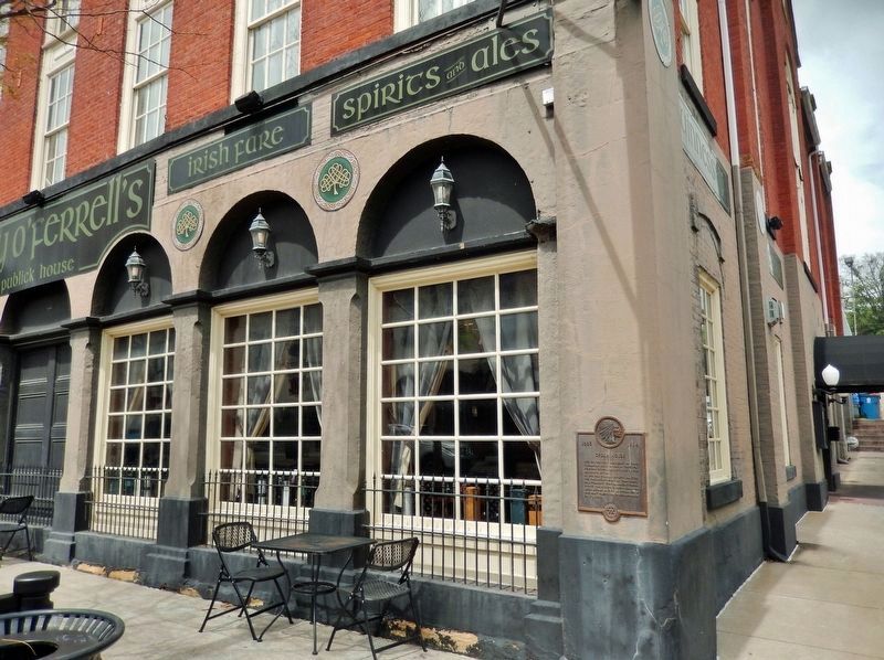
On Broadway Street just west of North Lorimier Street, on the right when traveling west.
Turner Hall, as this building was once known, was built in 1868 with contributions from members of the community. Designed by Nicholas Gonner, an architect, civil engineer and contractor in 1888, the Masons purchased Turner Hall & it became the . . . — — Map (db m236183) HM
Near Fort Street at Westport Street, on the right when traveling west.
After the Civil War, the forts and earthworks of Cape Girardeau slowly disappeared as the city grew. Finally, only Fort D remained. In the early 1900's the area surrounding the fort was developed as Fort D Highlands. A campaign by veterans, . . . — — Map (db m236814) HM
Terrace Park is located on the site where Father Odin of the Congregation of the Mission (Vincentian Fathers) established St. Vincent's Male Academy in 1838, which was followed shortly thereafter by St. Vincent's Seminary.
Often affectionately . . . — — Map (db m58663) HM
On Themis Street, 0 miles west of Main Street, on the right when traveling west.
1877 1896
Telephone Service
In 1877
The first long distance telephone line in Missouri was completed December 18, 1877 between Cape Girardeau and Jackson.
In 1896
Here in a 10' by 12' second floor room the city's first telephone . . . — — Map (db m38443) HM
Near Fort Street at Westport Street, on the right when traveling west.
The 20th Illinois Volunteer Infantry Regiment was formed in northern Illinois in April and May of 1861. On July 10, 1861, the regiment disembarked from a steamer at Cape Girardeau, the first formal Union troops to arrive in this city. One of the . . . — — Map (db m236813) HM
On North Lorimier Street south of Broadway Street, on the left when traveling south.
The coming of the machine age had little effect on the production of faience tiles. After eight centuries of producing faience, man has had little success in changing the methods of producing beautiful pieces of timeless durability. So when the . . . — — Map (db m236238) HM
Chicago artist, Thomas Melvin, and his lead portrait artist, Cameron Pfiffner, directed the paintings of the Mississippi River Tales, Mural between April and November of 2004. Other members of the crew are listed under the paint brush.
Sponsor: . . . — — Map (db m107852) HM
The Civil War
Dred Scott (1795-1858) was born into slavery in Virginia and relocated with the family when it moved to St. Louis in 1830. In 1846, he sued to gain his freedom. After 11 years, in a landmark decision, he was denied his freedom . . . — — Map (db m192154) HM
Near North Kingshighway Street (U.S. 61) at County Park Drive, on the right when traveling north.
The Regiment can trace its heritage back to the 6th Missouri Infantry that fought in the Civil War on the side of the South. Missouri was a “border state” during that conflict. Initially, the Regiment was comprised of men from southeast Missouri. . . . — — Map (db m236985) HM
On South Main Street, on the right when traveling south.
On Nov. 23, 1803, Meriwether Lewis and William Clark arrived at Cape Girardeau, a trading post established in 1795 by Louis Lorimier, the Spanish-appointed Commandant of the Cape Girardeau District. Here, Lewis, co-commander of the expedition, left . . . — — Map (db m58675) HM
On Water Street at Themis Street, on the right when traveling north on Water Street.
"The Father of Water" has provided means of travel and commerce since early days. Indians, explorers, priests, traders, and settlers plied its current in canoes, dugouts, flatboats, keelboats, packets, and towboats.
Until the Civil War, Cape . . . — — Map (db m52040) HM
On South Main Street, on the right when traveling south.
Pierre-Louis de Lorimier, French-Canadian fur trader, Indian agent, and founder of Cape Girardeau, built the Red House in the late 1790s west of this location on what is now the parking lot of St. Vincent's Church.
The Red House served as the . . . — — Map (db m58678) HM
On South Main Street, on the right when traveling south.
The Red House Interpretive Center, under construction from 2002-2004, is a cooperative effort of the Cape Girardeau Lewis and Clark Bicentennial Commission and the City of Cape Girardeau. The project was funded in part through grants from the . . . — — Map (db m58674) HM
On North Lorimier Street at Broadway Street, on the left when traveling north on North Lorimier Street.
[Lorimier Street marker] Built in 1924-25 newspaper owners George & Fred Naeter wrote of their inspiration: “to add in a large way beauty and dignity to one’s town is to express affection for the community and confidence in its future.” . . . — — Map (db m236100) HM
.
This panel features the Missouri State flag, which was designed by Cape Girardeau native, Maria Watkins Oliver. It was officially adopted March 22, 1913. Also represented are the official tree of Missouri - the dogwood, the official bird of . . . — — Map (db m107851) HM
Near Fort Street at Westport Street, on the right when traveling west.
During the winter, some of the soldiers stationed here dug shelters into the hillside. One soldier reported that his “mess” of four men built a covered shelter measuring ten feet long by eight feet wide. The top was covered with dirt, and a . . . — — Map (db m236821) HM
Near Fort Street at Westport Street, on the right when traveling west.
Their names may not be recorded in the official records, but thousands of women volunteered their time, labor and money during the Civil War. As a teenager, Julia Gill, a future resident of Cape Girardeau, volunteered her services as a nurse, . . . — — Map (db m236815) HM
Rosie O’Neill (1874-1944) was born in
Wilkes-Barre, PA. Her family later moved
to the Missouri Ozarks. She was a
commercial artist and creator of the
Kewpie doll, the first time ever that
merchandising was based on a comic
character. . . . — — Map (db m192146) HM
On State Highway 72, 3 miles west of County Route B, on the left when traveling north.
The Niswonger family came to this area from Lincoln Co. N.C. in a caravan of 20 families, they crossed the river on ice near Ste. Genevieve Jan. 1, 1800, then came south to the Whitewater creeks along which they settled. The family consisted of 3 . . . — — Map (db m33791) HM
On West Main Street at South High Street, on the left when traveling east on West Main Street.
In 1838 and 1839, twelve detachments with at least 11,000 weary Cherokee passed through Jackson, Missouri, on their journey to Indian Territory. Most of the groups followed the Northern Route of the Trail of Tears and came into town on Greensferry . . . — — Map (db m236844) HM
On West Main Street at South High Street, on the left when traveling east on West Main Street.
Home to thousands of men, women, and children, the Cherokee Nation once spread across parts of Georgia, North Carolina, Tennessee, and Alabama. The 1830 Indian Removal Act required that the Cherokee surrender their land and move west. In 1838, . . . — — Map (db m236826) HM
On Moccasin Springs Road, on the right when traveling west.
When this memorial was dedicated in 1961, legend said a Cherokee princess was buried here. Identified as the daughter of Reverend Jesse Bushyhead (left), a leader of a contingent of Cherokees on the Trail of Tears, a local group erected this pagoda . . . — — Map (db m235174) HM
On Overlook Road at Hill Road, on the right when traveling north on Overlook Road.
In 1672 Louis Joliet and Father Jacques Marquette were commissioned by King Louis XIV to discover the course of the Mississippi River. On June 17, 1673, the expedition entered the Mississippi from the Wisconsin River and began its descent by canoe. . . . — — Map (db m61828) HM
On Folger Street at Washington Street, on the right when traveling south on Folger Street.
Presented and placed atop the
Carroll County Courthouse
when building was erected 1902-1903
Removed in 1953 -- Erected this location
as a historical landmark in 1970
by the County Court. — — Map (db m90892) HM
On U.S. 65 at County Road 620/CC, on the right when traveling south on U.S. 65.
Born in County Tyrone · Ireland
May 10-1810
Died in Ottumwa · Iowa
June 1-1879
Soldier · Jurist · Statesman
United States Senator from
Illinois · Minnesota and Missouri
Cerro Gordo · Chapultepec
Winchester · Port Republic
Erected by . . . — — Map (db m90874) HM WM
On Main Street (Business U.S. 65) south of Benton Street, on the right when traveling south.
Born in County Tyrone, Ireland
May 10, 1810
Died June 1, 1879
Rests in St. Mary's Cemetery near
Carrollton, Missouri
Soldier · Statesman
Jurist · Patriot
Brigadier General
Mexican War · Civil War
Cerro Gordo · Winchester . . . — — Map (db m90890) HM WM
On North Mason Street south of U.S. 65, on the right when traveling north.
On Oct. 24, 1838 about 800 Potawatomi Indians camped near Carrollton on forced emigration from Indiana to Kansas. Cold was intense on the prairie. — — Map (db m198474) HM
On Jefferson Street at 7th Street, on the right when traveling west on Jefferson Street.
(side 1) Fort Orleans, first European post in the Missouri Valley, was built by the French explorer Etienne Véniard De Bourgmond on the Missouri River close by, a few miles above the mouth of the Grand, 1723-24. The exact location of the . . . — — Map (db m132000) HM
On Oct. 23, 1838, about 800 Potawatomi Indians camped near here on the forced removal from Indiana to Kansas. They camped at Thomas' encampment. Having marched 10 miles after ferrying the Grand River. Wet bottom lands and severe cold made the march . . . — — Map (db m198473) HM
Big Spring rises through a jumble of giant boulders causing a dramatic “boil” at the spring surface. On an average day 288 million gallons of water flow from the spring, enough to fill Busch Stadium in St. Louis in only 33 . . . — — Map (db m61738) HM
Karst is a special type of landscape that is formed by the dissolution of soluble rocks, including limestone and dolomite.
A karst topography is characterized by rolling hills, deep hollows springs, caves, sinkholes and tunnels.
Rain water, . . . — — Map (db m61739) HM
On State Highway Z at Pea Vine Road (State Highway 103), on the right when traveling north on State Highway Z.
"We are definitely in an era of building; the best kind of building - the building of great public projects for the benefit of the public and with the definite objective of building human happiness." Franklin Delano Roosevelt Growing out of . . . — — Map (db m36208) HM
On State Highway Z at Pea Vine Road (State Highway 103), on the right when traveling north on State Highway Z.
"Company 1710 was organized at Fort Leavenworth, Kansas, June 3, 1933...The company was made up of approximately 200 Missouri boys, 96 from three north Missouri counties (Putnam, Caldwell, Lynn) and the remainder from Jasper County.... On June . . . — — Map (db m36195) HM
On Main Street (Business U.S. 60) at Oliver Street, on the right when traveling north on Main Street.
(Front):Erected by the citizens of Carter County in memory of our soldier boys who lost their lives in World War of 1917William Thomas Main Charles O. Marchbank Oscar Marchbank George L. Shiffler Ed. Morler J.L. Kinnard Charles E. McSpadden . . . — — Map (db m36150) WM
On State Highway Z at Pea Vine Road (State Highway 103), on the right when traveling north on State Highway Z.
During the 1930s, a depression slowly strangled the nation. By 1933, nearly 13 million people suffered unemployment. In March, newly elected president Franklin D. Roosevelt responded with a bill creating the Civilian Conservation Corps. Its purpose . . . — — Map (db m36191) HM
On State Highway Z at Pea Vine Road (State Highway 103), on the right when traveling north on State Highway Z.
The CCC worked within state and national parks and forest areas across the nation combating soil erosion, fighting forest fires and building park facilities. At Big Spring, boys from 3 separate camps (Co. 1710, 734 and 1740) kept busy with a variety . . . — — Map (db m36196) HM
On Main Street (Business U.S. 60) at Oliver Street, on the right when traveling north on Main Street.
(Front): Van Buren, settled as the seat of Ripley County, organized, 1833, became the seat of Carter County when it was organized from parts of Ripley and Shannon counties, 1859. Nearby Big Spring State Park, 4582 acres of Ozark grandeur, . . . — — Map (db m36143) HM
On Chestnut Street at 2nd Street, on the right when traveling west on Chestnut Street.
Peace Park
Love + Labor + Leisure + Light + Law=
"Peace"
A memorial to
Mr. & Mrs. G. W. Smoot
given to City of Belton by daughter
Cynthia Smoot Jones
1956
Dedicated to those who served
Dedicated Veteran's Day
Nov. 11, . . . — — Map (db m50860) WM
On Missouri Route 2, 0.2 miles U.S. 71, on the left when traveling west.
The Civil War on the Missouri-Kansas border was an extension of the raiding and looting that took place during the Bleeding Kansas era of 1854 to 1860. Early in the war, Kansas Jayhawkers and Redlegs dressed in blue Union uniforms looted and . . . — — Map (db m20318) HM
On East Wall Street, on the left when traveling east.
Midway on Missouri's western border, Cass County was organized in 1835 and named Van Buren. The Free-Soil Party affiliation of Martin Van Buren led to name change, in 1849 for Democrat Lewis Cass. In territory ceded by Osage tribes 1825, the county . . . — — Map (db m20267) HM
On Lexington Street at Pearl Street, on the left when traveling north on Lexington Street.
(No inscription except for the title and portraits of significant personalities. This historical marker tells its story pictorially.)
[Portraits of]
Lewis Cass • L.O. Kunze
Henry & Bursheba Younger
[William] Quantrill • Cole Younger . . . — — Map (db m50871) HM
On North Commercial Street at Locust Street, on the left when traveling east on North Commercial Street.
left tablet
Stylized Eagle facing right perched on 3 arrows
Lest we forget
Korea
map of Korearight tablet
Stylized Eagle facing left perched on 3 arrows
Lest we forget
Vietnam
map of Vietnam . . . — — Map (db m21314) WM
On West Wall Street (Missouri Route 2) 0.2 miles west of U.S. 71, on the left when traveling west.
(Left Side Plaque)
The Burnt District / Jennison's Tombstones
When the Civil War began, Cass County was home to over 1,700 families. The population of 8,900 free whites and 1,000 slaves reflected widely diverse origins. Many had . . . — — Map (db m22089) HM
The Cass Co. Judges who suffered imprisonment by the U.S. Federal Courts rather than make a tax levy to pay fraudulent Co. and Township Railroad Bonds.
FE Johnston
WP Barnes
Sept 1 1883 to Jan 1 1884
WA Wray
FM George
ET . . . — — Map (db m20268) HM
On Prettyman Road, 1.2 miles west of Missouri Route 291, on the left when traveling north.
has been placed on the
National Register
of Historic Places
by the United States
Department of the Interior
Not open to the public — — Map (db m99463) HM
On Veterans Parkway at Cedar Street, on the right when traveling north on Veterans Parkway.
Operated as a grocery store/meat market until 1981 when a delicatessen was added. Building was destroyed by fire in 1891 and rebuilt at that time. From 1984 until 2006 various tenants operated out of the building. In 2006 the building was renovated . . . — — Map (db m88326) HM
On 1st Street south of Wyoming Street, on the right when traveling north.
In 1858 John Armstrong purchased this and surrounding land from the U.S. knowing the Pacific Railroad would site its station here. Armstrong sold some land to the railroad for $1.00. By 1865, when the railroad began construction, business men from . . . — — Map (db m88421) HM
On Veterans Parkway south of Cedar Street, on the left when traveling south.
This building has housed a theatre since 1909. In 1915 free Sat. matinees were sponsored by the merchants for country people. Nov. 7, 1916 it was packed with people waiting to hear the national election results coming in over a telephone line . . . — — Map (db m88328) HM
On 1st Street north of Commercial Street, on the right when traveling north.
This building was the post office from 1874-90. Other tenants included an insurance agency, a variety store, a shoe shop, and the Commercial Bank (1912). Since 1955 it has been a radio and TV shop, photo shop, telephone office, watch repair shop, . . . — — Map (db m88423) HM
On Wyoming Street at 1st Street, on the right when traveling west on Wyoming Street.
Until 1977 this building was always a drug store. Some space was rented to the Mo. Kan. Telephone System (Bell) for their central office. A veterinarian also leased space. A church leased the building from 1977 to 1986 at which time Randy and Bettie . . . — — Map (db m88417) HM
On 1st Street north of Commercial Street, on the right when traveling north.
From 1895 to 1913 Rolly Brothers restaurant was here. They had a waiting room for ladies in front and a dining room being cut off by a row of palms. In 1904 the rear half was added facing the Mo. Pacific Depot enabling the restaurant to cater to the . . . — — Map (db m88569) HM
On 1st Street south of Wyoming Street, on the right when traveling south.
First housed a funeral parlor until 1906. For the next 52 years O.L. Beasley and his heirs the Woodmancys operated a clothing store. From 1962-77, it was a sporting goods and liquor store. Later a pawn shop. After extensive remodeling it became a . . . — — Map (db m88425) HM
On 1st Street north of Commercial Street, on the right when traveling north.
The first building was destroyed by fire in 1893. In 1907 the present building was erected for a pool hall. It was constructed to hold a second story that was never built on. The pool hall is believed to be the oldest in the state of Missouri . . . — — Map (db m88567) HM
On 1st Street south of Wyoming Street, on the right when traveling south.
No record available of when 120 First St. was built. From 1902 to 1907 it was a post office. From 1907 to 1930 a grocery store. On July 26, 1909 Carrie Nation gave a lecture in front about the evils of alcohol. It has been an electrical shop, . . . — — Map (db m88428) HM
On 1st Street north of Commercial Street, on the right when traveling north.
In June 1894, the new building was the home of a drug store. The upstairs was occupied by a savings & loan co and a real estate co. In 1904 the upstairs became the offices of a doctor and a lawyer. In 1929 a bakery was opened downstairs, then a . . . — — Map (db m88485) HM
On 1st Street south of Wyoming Street, on the right when traveling south.
This building was the home of the Citizens State Bank from 1893-1943. The assets were purchased and incorporated into the Pleasant Hill Bank. From 1943-58 it was a shoe and dress shop. In 1958 it became a liquor store for several years. Later it . . . — — Map (db m88429) HM
On 1st Street south of Wyoming Street, on the right when traveling south.
From 1900 until 1915 this building was the home of various jewelry businesses, then the Bargain Spot and in 1917 a shoe shop. From 1919-1921 it was a millinery store. Early 1921 it was a feed store. Later that year Pleasant Hill Times Publisher Roy . . . — — Map (db m88460) HM
On Wyoming Street west of 1st Street, on the right when traveling west.
The first frame building was built in 1868 as a home for boots and shoes. It was a shoe repair shop until 1916. In 1920 Jones Lumber Co. was moved to this location after the original building was razed. Later it was a shoe repair and store until . . . — — Map (db m88419) HM
On 1st Street south of Wyoming Street, on the right when traveling south.
Since 1890 this location has been a barber shop. Half the building has been an insurance agency and jewelry store. A new barber pole was installed in 1908. It is now in Miller's Museum.
Current owner is Joan Mitchell — — Map (db m88462) HM
On Commercial Street at 1st Street, on the left when traveling east on Commercial Street.
Constructed for $11,000 by John C. Knorpp, the second floor became the Knorpp Opera House, featuring vaudeville, drama and community functions. The ground floor became a grocery. In 1893 the opera hall was leased to the Masonic Lodge then, in 1904 . . . — — Map (db m88479) HM
On 1st Street north of Commercial Street, on the left when traveling north.
A bakery was here 1867-95. In 1891 a fire started up the street. Men were on top of 136 pouring on water from a line of buckets. A restaurant here in 1905 with sleeping rooms upstairs advertised "25 cents gets a square meal." In 1920 a cleaning and . . . — — Map (db m88469) HM
On Commercial Street at 1st Street, on the right when traveling west on Commercial Street.
Was first used as a savings bank and housed banks until 1908. By 1890 the upper floors were used as lodge halls. Other occupants were dentists, real estate, loan, insurance, lawyers, telephone office and living quarters. The first floor has been . . . — — Map (db m88474) HM
On Cedar Street at Taylor Street, on the right when traveling east on Cedar Street.
This was the original site of the stone mill owned by F.H. Marshal and Son. Here they operated a corn mill, saw mill, a turning lathe and repair shop. In 1898, the top was removed so the red brick Kellogg Opera House could be built on the . . . — — Map (db m88321) HM
These Hallowed Grounds hold the remains of George W. Armstead, Ira W. Crouse, W. H. Darling, J. L. Warren and 23 other Civil War Soldiers known but to God, who lost their lives on July 11, 1862 and May 15, 1863. — — Map (db m88292) HM WM
On Paul Street at Broadway / Boardman St / Wyoming St, on the left when traveling west on Paul Street.
One of the finest artillery units of the Civil War was Bledsoe's Battery, commanded by Col. Hiriam Bledsoe, a resident of Pleasant Hill.
Born in Kentucky, he moved at age 14 to Lexington, Mo. In 1846 he joined the U. S. Army, Missouri . . . — — Map (db m88348) HM WM
On Veterans Parkway (AKA Lake Street) at Locust Street, in the median on Veterans Parkway (AKA Lake Street).
"I see that the old flagpole still stands. Have your troops hoist the Colors to its peak, and let no enemy ever haul them down."
Gen. Douglas MacArthur
"To be prepared for war is one of the most effectual means of preserving peace." . . . — — Map (db m88344) WM
On Wyoming Street at 1st Street, on the right when traveling west on Wyoming Street.
This oldest building downtown stands on the original Pleasant Hill land grant of 1854 with a 126 years of continuous use.
In the 19th century, it was a furniture store and the town post office.
In the 20th century, it housed grocery stores, . . . — — Map (db m88415) HM
On Paul Street at Veterans Parkway (AKA Lake St), on the right when traveling west on Paul Street.
In 1944 the American Legion and American War Dads joined forces to honor the war dead with this Memorial Building. In 1947 the V.F.W. and the Ladies Auxiliaries joined them in a fund drive to save expenses. Volunteers cleaned salvaged bricks until . . . — — Map (db m88372) HM WM
On Boardman Street south of Paul Street / Wyoming Street, on the right when traveling south.
The first depot was of wood frame and built on this site in 1866. It burned in 1901. In 1903 this building was built for the Missouri Pacific R.R. and called the "finest in the state." In 1915 the Wells Fargo office here was robbed. The night man . . . — — Map (db m88338) HM
2nd. Lieutenant
138 Field Artillery, U.S.A.
who died after serving his
country in the World War
Volunteered April 26, went to France in December, 1917. At all times Corporal in the Field Artillery, 2nd Division Intelligence G2 Section . . . — — Map (db m88291) HM WM
On Veterans Parkway (AKA Lake Street) at Paul Street, on the right when traveling south on Veterans Parkway (AKA Lake Street).
[Side A]
Pleasant Hill dates back to Missouri's early pioneer days. As early as 1823, there was a trading post located two miles east of the present town that was operated by a French Canadian by the name of Blois.
In 1828, David Creek . . . — — Map (db m88330) HM
On Paul Street at Broadway / Boardman St / Wyoming St, on the left when traveling west on Paul Street.
The American Civil War had a profound and long-lasting impact on the Pleasant Hill area. Its location in the border state of Missouri ensured that residents would align themselves on both sides of the conflict. Numerous skirmishes were fought . . . — — Map (db m88350) HM
On Missouri Route 7 at Matthes Lane on State Route 7.
In memory of those who gave their lives that we might live in peace
World War I
James H. Biggerstaff • James L. Carpenter • Earnest J. Ditto • Newton J. Dudley • Wilford A. Fair • Jesse J. Hayes • Joseph S. Konantz • Joe Shelton • James S. . . . — — Map (db m88278) WM
El Dorado Springs was founded around this spring in 1881 due to the waters medicinal value. The stone above marked its first site 75 ft. to the SE until 1890 when routed to this basin. During repairs in Sept. 1992, this sandstone slab was found . . . — — Map (db m57372) HM
On Grand Avenue at Pine Street, on the left when traveling south on Grand Avenue.
This bell has been donated by the Rock School District of Cedar County Missouri in commemoration of the former Common School Districts which presently comprise the El Dorado Springs R-2 School District.
Cedar County
Barnes • Cedar Springs . . . — — Map (db m57417) HM
Before El Dorado Springs was founded, this stone wash basin sat before the Spring on rock supports. It was used by travelers along the trail. Some pioneer artisan cut it from a stone taken from Grindstone Quarry, located East of the Park Hotel. . . . — — Map (db m57377) HM
On Main Street (Missouri Route 82) 0.3 miles north of U.S. 54, on the left when traveling north.
This wagon represented the State of Missouri in the 1976 Bicentennial Wagon Train Pilgrimage to Valley Forge, Pennsylvania
Wagon Master, Raymond Williams
Asst. Wagon Master, Jack Nolan
Outriders, Georgia Williams
Dixie Nolan-Peak and . . . — — Map (db m57421) HM
Realizing it was believed by the general public that the spring water had some medicinal value and that people were coming great distances to drink the water for whatever ailments they had, Nathaniel H. and Waldo P. Cruce, brothers, had the . . . — — Map (db m57380) HM
On Spring Street near Main Street (Missouri Route 82), on the left when traveling west.
A sea of grasses and wildflowers - the tallgrass prairie - once covered America's heartland. It is now one of the most endangered ecosystems in the world, and many of its inhabitants are struggling to survive.
Thousands of acres of rolling . . . — — Map (db m57202) HM
This monument is dedicated to Roy Bandy and Eddy Wilson for their efforts in providing career and work opportunities for young people in the field of cadastral (land) surveying with the General Land Office and its successor, the Bureau of Land . . . — — Map (db m57381) HM
On South Street (Missouri Route 39) south of Wells Street, on the right when traveling south.
(side 1)
Here where the Ozark Highland borders on the Western Prairie region of Missouri, Cedar County was organized in 1845. The name is for the trees along Cedar Creek. Stockton, the county seat, was platted in 1846 on land given by . . . — — Map (db m72914) HM
On South Street (Missouri Route 39) at Jackson Street, on the right when traveling south on South Street.
In honored memory of those from Cedar County who lost their lives in World War One, World War Two, the Korean and Vietnam Conflicts. These Heroes live beyond the tomb.
[Roll of Honored Dead]
And to all those who fought valiantly for . . . — — Map (db m79791) WM
On West Broadway Street (U.S. 24) east of South Polk Street, on the left when traveling east.
The World's Largest Pecan was built by George and Elizabeth James, in 1982. It was a tribute to a large, hardy, northern pecan that they found on their farm, James Pecan Farm, Inc. in the early 1950's. This patented nut, the starking hardy giant, . . . — — Map (db m198479) HM
Near South Polk Street near East Mulberry Street, on the right.
On Oct. 22, 1838, about 800 Potawatomi Indians began ferrying the Grand River as they walked from Indiana to Kansas on the forced removal. By dark all the Indians and many of the wagons were over the river and ferried the rest the next day. — — Map (db m198471) HM
Near West Bridge Street east of North Park Street, on the left when traveling east.
Born in Prince Edward County, Virginia September 11, 1809 Resided in Chariton County Missouri 1831-1865 Speaker Of the House of Representatives Of Missouri General Assembly 1840-1844 Elected to Congress 1844 Participated in War with Mexico 1846-1848 . . . — — Map (db m131899) HM WM
4176 entries matched your criteria. Entries 301 through 400 are listed above. ⊲ Previous 100 — Next 100 ⊳