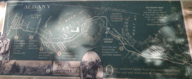
On Passaconaway Road east of Kancamagus Highway (New Hampshire Route 112), on the right when traveling east.
Today a trip to town takes minutes.
For homesteaders, traveling the bumpy 15 miles to Conway by wagon took 3 hours, on a good day.
Trips to the store would not have been casual affairs, but a chance to stock up on supplies.
50 lb. sacks . . . — — Map (db m116172) HM
Near Passaconaway Road east of Kancamagus Highway (New Hampshire Route 112) when traveling east.
Local Ideas
Builder Amzi Russell who lived at what is now the Russell-Colbath homestead, was an industrious and versatile nearby builder.
His crew of three to thirty local hands were not engineers. But they were extremely skilled craftsmen . . . — — Map (db m116180) HM
Near Kancamagus Highway (State Road 112) 2.9 miles west of Passaconaway Road, on the right when traveling west.
When the railroads came to Conway
In 1864, the White Mountains became more accessible to tourists when the Boston & Maine Railroad brought its lines into Conway. The grueling three-day stagecoach journey from Boston became an easy four-hour . . . — — Map (db m259174) HM
On Main Street (U.S. 302) at Albany Avenue, on the left when traveling west on Main Street.
This snow roller, donated by Francis Savard of Intervale Farm, was once used to roll the roads in the Intervale section of Bartlett. Prior to the advent of snowplows, snow rolling was a common method of keeping the snow-covered roads passable in . . . — — Map (db m160823) HM
On Main Street (U.S. 302) at River Street, on the right when traveling east on Main Street.
This piece of Sawyer's Rock represents the traditional landmark for the town line between Harts Location and the town of Bartlett. In 1870, Benjamin Sawyer and his partner Timothy Nash set out to prove to governor Wentworth that men and horses . . . — — Map (db m160826) HM
On West Side Road 2.2 miles north of River Road, on the left when traveling south.
This rustic cottage was once the home of Thomas Murphy and his wife, Lady Blanche, daughter of the Earl of Gainsborough. Thomas was the organist at the church on the Earl's estate. The commoner and the lady eloped to America, where Thomas taught at . . . — — Map (db m77640) HM
On Chocorua Mountain Highway (New Hampshire Route 16) 0.8 miles north of Chocorua Lake Road, on the left when traveling north.
In several versions, the legend’s sequence relates the mysterious death of Chocorua’s son while in the care of a settler named Campbell. Suspicious of the cause, the Pequawket chieftain took revenge on the settler’s family. Then, in retaliation, . . . — — Map (db m152078) HM
On Kancamagus Highway (Scenic State Road 112) 0.6 miles west of Passaconaway Road, on the right when traveling west.
Prior to the 1930s, the road from Conway along the 1 Swift River ended in the Passaconaway Valley in Albany. The road's route ran farther away from Lower Falls than the present-day Kancamagus Highway. Consequently, no mentions of Lower Falls . . . — — Map (db m258657) HM
On New Hampshire Route 112 0.3 miles west of Moat View Drive, on the right when traveling west.
Kancamagus Highway
This scenic highway through the White Mountain National Forest was constructed through the combined efforts of the New Hampshire Department of Public Works and Highways, the U.S. Bureau of Public Roads, and . . . — — Map (db m102137) HM
On West Side Road at Hillside Avenue, on the right when traveling north on West Side Road.
Restored in
1991
Through generous donations
of many private citizens
and the taxpayers of
the Town of Conway
uniting to preserve a symbol
of our community heritage. — — Map (db m162705) HM
On Skimobile Road, on the right when traveling east.
Father of Modern Skiing
Founder World's First Ski School
St. Anton, Austria 1907
Director, Hannes Schneider Ski School
Mount Cranmore 1939 - 1955
Unveiled February 5, 1989
Cranmore's 50th Anniversary
Edward Materson, . . . — — Map (db m243942) HM
On Intervale Cross Road 0.2 miles east of White Mountain Highway (U.S. 302), on the left when traveling east.
Author of Abenaki & English Dialogues Born 1839 —— Died 1917 St. Francis Indian Reserve, Odanak, Quebec In 1884 he led back to the land of their fathers a group of Abenaki and Sokoki Indians and established here in the woods of . . . — — Map (db m78682) HM
On U.S. 302 0.1 miles south of Hurricane Mountain Road, on the right when traveling south.
Since Thomas Cole's visit in 1828, New Hampshire's splendid scenery has been an enduring inspiration to countless landscape artists. From 1850 to 1890 this region was particularly favored for their easels. Benjamin Champney (1817-1907), New . . . — — Map (db m74557) HM
New Hampshire Fish & Game Law Enforcement
Served 1990 - 2013
Steadfast and committed to protecting the wildlife and citizenry of this great state — — Map (db m239144) HM
On U.S. 302 west of White Mountain Road ( Route 16), on the left when traveling west.
Between 1771 and 1785, a rough road through
Crawford Notch was constructed to facilitate
trade and travel. In the early 1800s, the
Tenth New Hampshire Turnpike was built along
the old road, from Bartlett through the Notch.
Spurred on by . . . — — Map (db m162703) HM
On Crawford Notch Road (U.S. 302), on the right when traveling north.
The high steel trestle above was built in 1893 to replace a wrought iron trestle of 1875, and was strengthened in 1930 and 1950. Named for American Artist Godfrey N. Frankenstein (1820-1873), the adjacent cliff and gulf were formidable barriers to . . . — — Map (db m77698) HM
On Crawford Notch Road (U.S. 302) west of White Mountain Road ( Route 16), on the right when traveling east.
In 1771, Timothy Lash of Lancaster and Benjamin Sawyer of Conway made a bargain with Governor John Wentworth to bring a horse through Crawford Notch in order to prove the route’s commercial value. The pair succeeded by dragging and lowering the . . . — — Map (db m239145) HM
On Main Street (New Hampshire Route 16A) at Carter Notch Road ( Route 16B), on the right when traveling east on Main Street.
Stone Bridge built 1931 placed on the National Register of Historic Places as part of the Jackson Falls Historic District by the United States Department of the Interior — — Map (db m161314) HM
On East Madison Road at Village Road ( Route 113), on the left when traveling south on East Madison Road.
Nearby is the birthplace of the Granville brothers Zantford (Granny), Thomas, Robert, Mark and Edward and sisters Pearle and Gladys. With Madison natives Hiram Jones, Harry Jones, and Elson Ward, they formed the Granville Brothers Aircraft Co. in . . . — — Map (db m192062) HM
Near Norcross Circle 0.1 miles west of White Mountain Road (U.S. 302).
This BALL SIGNAL was once located at WAUMBEK JUNCTION, a crossing of the Maine Central R.R. and Boston & Maine R.R. in the Town of Jefferson, New Hampshire. The signal was operated by a member of the train crew. One ball raised to the masthead . . . — — Map (db m78692) HM
Near Norcross Circle 0.1 miles west of White Mountain Road (U.S. 302).
This caboose, one of 500 similar units that once served on the Boston & Maine Railroad, was built by the B&M at their shops in East Fitchburg, Mass. in 1907. Many were later rebuilt with steel underframes, steel trucks, and full-width cupola. This . . . — — Map (db m78324) HM
Near Norcross Circle 0.1 miles west of White Mountain Road (U.S. 302).
This caboose was built in the year 1910 at the Central Vermont Railway shops in St. Albans, Vermont. It later was modified with a steel underframe about 1925. Most of its 60 years of service were spent in southern New England on the Central . . . — — Map (db m79065) HM
Near Norcross Circle 0.1 miles west of White Mountain Road (U.S. 302).
This 23 ton caboose is owned by John Egan of Largo, FL and formerly of Gorham, NH. The car was built about 1915 by Central Vermont Railway in their shops at St. Albans, VT. About 1930 it was transferred to the affiliated Grand Trunk Railway. John . . . — — Map (db m78684) HM
Near Norcross Circle 0.1 miles west of White Mountains Road (U.S. 302).
Crossing Gates of this sort once protected busy road crossings throughout the United States. They were usually operated by a full time crossing tender, a man or woman that worked out of a small "crossing shanty" that offered some protection from the . . . — — Map (db m78362) HM
Near Norcross Circle 0.1 miles west of White Mountains Road (U.S. 302).
This unusual car has two air-operated flanger blades that drop down to remove snow from between the rails. The car is 34 feet long and weighs over 20 tons. The 4233 was built by the Erie Car Works of Erie, Pa. in 1891 for the Central Vermont . . . — — Map (db m78337) HM
Near Norcross Circle 0.1 miles west of White Mountains Road (U.S. 302).
This freight house was built about 1872 by the Portsmouth, Great Falls & Conway Railroad. This building became the commercial center of the growing village of North Conway, as box car loads of supplies for the local merchants and farmers were . . . — — Map (db m78344) HM
Near Norcross Circle 0.1 miles west of White Mountains Road (U.S. 302).
In 1914 the Pullman Company built this all steel car as a 87 seat coach-smoker for the Maine Central Railroad. It started out as Maine Central No. 252, and was later renumbered 209 with seating capacity reduced to 73, with 11 seats in the smoking . . . — — Map (db m78343) HM
On White Mountain Road (U.S. 302) at Kearsarge Road, on the right when traveling north on White Mountain Road.
North Conway 5¢ and 10¢ Store is listed on the National Register Of Historic Places by the United States Department of the Interior — — Map (db m78246) HM
Near Norcross Circle 0.1 miles west of White Mountains Road (U.S. 302).
Built Ca. 1874 by the Portsmouth, Great Falls, and Conway Railroad. For well over a century this sturdy old building, with its four stalls, has served as a shelter where locomotives can be repaired, serviced and stored. Over the years stalls have . . . — — Map (db m78338) HM
On White Mountain Road (U.S. 302) at Norcross Circle, on the right when traveling south on White Mountain Road.
By vote of the Conway town meeting of 1924 the $3,000 bequest of Dr. James Schouler was used to buy this land from the Boston and Maine Railroad. It was deeded to the town on express condition that it be used only for a public park, and named . . . — — Map (db m78325) HM
On Norcross Circle 0.1 miles west of White Mountain Highway (U.S. 302), on the right when traveling south.
In 1872 the tracks of the Portsmouth, Great Falls & Conway Railroad were completed to North Conway, and in 1874 the railroad built this magnificent building to serve as their depot and offices. Nathaniel J. Bradlee, a well-known Boston architect, . . . — — Map (db m78859) HM
Near Norcross Circle at White Mountain Road (U.S. 302).
A memorial to those who served in the World War from North Conway, New Hampshire 1917 1919
Dora Anderson, A.N.C. ·
John L Barnes ·
James L Blue ·
Norman W Brackett ·
Harold O Cady ·
Donald W Carter ·
Bernard M Carter · . . . — — Map (db m78326) WM
Near Norcross Circle 0.1 miles west of White Mountains Road (U.S. 302).
This device, erected in 1978, is used to fill a steam locomotive's tender tank with fresh water. The coal fire in a steam locomotive heats tremendous amounts of water to produce the steam that powers the train. The tender tank in Conway Scenic . . . — — Map (db m79066) HM
Near Norcross Circle 0.1 miles west of White Mountains Road (U.S. 302).
An approaching train sets this signal in motion, with the red disc swinging back and forth, the red lights flashing in sequence and the ringing of the warning bell. This obsolete machine, one of many similar ones that once guarded rural highways in . . . — — Map (db m78361) HM
On Durgin Bridge Road, on the left when traveling north.
Built by Jacob Berry of North
Conway, this bridge is the fourth
to span Swift River here since 1820.
Freshets in 1844, 1865 and 1869
destroyed the first three. The bridge
is named for James Holmes Durgin
(1815-73) who ran a grist mill . . . — — Map (db m312802) HM
On White Mountain Highway (New Hampshire Route 16) at Route 16B, on the right when traveling north on White Mountain Highway.
Was fought between 1722 and 1725 against several tribes of eastern Indians. The principal campaigns took place in the Ossipee region and led to the eventual withdrawal of the Indians to the north. Commemorated in Colonial literature by “The Ballad . . . — — Map (db m152069) HM
On Wentworth Hill Road, on the right when traveling south.
The first house in town was built on this hill.
Daniel Beede and 15 men built a log house in
Nov. 1767. Beede was a dominant character in
the early history of Sandwich, a surveyor, a
businessman, the first town clerk and on the
first Board of . . . — — Map (db m313285) HM
On Tamworth Road (New Hampshire Route 113) at Main Street, on the left when traveling east on Tamworth Road.
Nearby stands "The Barnstormers" summer playhouse, the oldest in New Hampshire and one of the first in the nation. Opened in 1931, at one time the cast covered a weekly 80-mile circuit. Currently its performances are limited to this community. . . . — — Map (db m97057) HM
On Tamworth Road (New Hampshire Route 116) near Main Street, on the left when traveling east.
Erected by the Town of Tamworth In memory of those who served their country. "To you from failing hands we throw the torch - be yours to hold it high." — — Map (db m97062) WM
On New Hampshire Route 109, on the right when traveling north.
Abenaki Tower, dedicated in 1924, is located on N'dakinna, the traditional lands of the Abenaki Peoples past and present. The lookout is located near the junction of two trails: the Sobagw (Ocean) Trail and the Awasebi (Beyond the Water) Trail. . . . — — Map (db m234614) HM
On New Hampshire Route 109 at Lake Road, on the right when traveling east on New Hampshire Route 109.
The nearby granite marker is the first known monument in New Hampshire marking the reparation and reburial of an Indigenous individual. In 1809, the remains of a reportedly 7-foot tall Abenaki man were found along the banks of the Melvin River: . . . — — Map (db m234612) HM
On North Main Street (New Hampshire Route 109) at Lang Pond Road, on the right when traveling north on North Main Street.
Governor John Wentworth and the King's Council voted in the spring of 1771 that a highway be made from the Governor's estate at Wolfeborough to Dartmouth College.
Joseph Senter, David Copp and Samuel Shepard surveyed the 67-mile road which . . . — — Map (db m234615) HM
On Center Street just north of Willow Street, on the right when traveling north.
Stuarts in North Africa Stuart tanks First saw combat with the British in Operation Torch (November 8-11, 1942) during the North Africa Campaign (June 10, 1940-May 13, 1943). Of the more than 700 tanks that took part in the operation, about 170 . . . — — Map (db m152106) HM
Near Center Street (New Hampshire Route 28) 0.1 miles north of Willow Street, on the left when traveling north.
Two photos show the station at very different times. The one above is early on when the area was still called Mill Village and taken perhaps even before 1900 when the station first housed the Post Office. In 1892 the PO was subsequently moved across . . . — — Map (db m152101) HM
Purchased and moved to this site in 1930 by Milton and Eva B. "Short" Seeley, these kennels produced sled dogs for exploration, racing, and showing. For almost 50 years Chinook Kennels exerted a profound influence upon the Alaskan Malamute and . . . — — Map (db m95817) HM
The Boston, Concord & Montreal Railroad was chartered in 1844. Construction of the main line began in Concord in 1846. The tracks were completed to Laconia in 1848, to Ashland in 1849, and to Wells River, Vermont in 1853. The B. C&M RR merged with . . . — — Map (db m74567) HM
On Daniel Webster Highway at Main Street on Daniel Webster Highway.
Nearby, on Pleasant Street, is the birthplace and childhood home of George Hoyt Whipple, pathologist, researcher and teacher. Dr. Whipple’s most significant research led to the development of the liver therapy for pernicious anemia. For his work, he . . . — — Map (db m74568) HM
In Memory of the Soldiers of Ashland in the War. 1861-1865. Erected by the town. G.M. Keye’s Post G.A.R. and Woman’s Relief Corps. Dedicated May 30th 1899. Town Committee: Thomas E. Greney-6th N. H. Vol’s, Frank L. Hughes-12th N. H. Vol’s, Edward P. . . . — — Map (db m65884) HM
On Rum Hill Road (U.S. 302), on the right when traveling south.
Settled in 1766 by Jaasiel Harriman whose cabin was near the Great Rock. His nine year old daughter Mercy carried dirt in her apron to the top of this unique rock formation. Here she planted corn, pumpkins and cucumbers, making the first garden . . . — — Map (db m74569) HM
On Lisbon Road (U.S. 302), on the left when traveling east.
Stones from a grist mill erected on Hurd's Brook in 1805 by Stephen Smith. One of ten in Bath, the mill ran until about 1820 on land of Edward & Goldie Harris who gave the stones to the town in 1965. — — Map (db m280431) HM
On Lisbon Road (U.S. 302) at Bath Road, on the right when traveling west on Lisbon Road.
In Honor of the Men who enlisted from
Bath in the wars of our country
Revolutionary War
Aaron Bayley • Cyrus Bayley • John Beard • Daniel Bedel • Jacob Bedel • John Bedel • Joshua Bedel • Moody Bedel • Richard Bedel • Robert . . . — — Map (db m280441) WM
On Wild Ammonoosuc Road (New Hampshire Route 112) at Lisbon Road (U.S. 302), on the right when traveling north on Wild Ammonoosuc Road.
Erected in 1928, this riveted steel Warren truss span was built to replace a wooded span destroyed in the 1927 flood. This efficient truss design is based on a series of equilateral triangles with verticals added for strength. Boston Bridge Works . . . — — Map (db m75772) HM
On NH Hwy 25 near Boucher Road, on the left when traveling south.
The US Forest Service purchased 7,072 acres of timber-covered mountain slopes, cliffs, streams, ponds, and abandoned farmland from Haverhill
businessman E. Bertram Pike on January 2, 1914.
The purchase was the first acquisition towards . . . — — Map (db m312890) HM
On Whitefield Road (New Hampshire Route 116) at Deer Run Road, on the right when traveling west on Whitefield Road.
Alderbrook developed around a sawmill built by H.C. Libbey in 1877. The Village grew to include a post office, a dozen company-owned houses, a boarding house, school and railroad station. The mill employed as many as 40 to 60 men and cut as much as . . . — — Map (db m77642) HM
On Main Street (U.S. 302) east of Park Avenue, on the right when traveling east. Reported permanently removed.
This house was built in 1893 for the William O. Kelner Family who named it The Gables. Builder S.D. Morgan graced this Queen Anne style home with lavish interior woodwork to include a six panel picture window on the landing of a uniquely detailed . . . — — Map (db m116540) HM
On Main Street (U.S. 302) at Berkley Street, on the left when traveling east on Main Street.
The country club opened as a 9-hole course in 1898 under
the ownership of the Bethlehem Park Association. The
original club house was located at the corner of Park Avenue
and Pine Street. The course was redesigned as an 18-hole
course by . . . — — Map (db m280591) HM
On Strawberry Hill Road south of Main Street (U.S. 302), on the left when traveling south.
This synagogue was originally the Church of the Nativity, built
in 1877, on land donated by Rhode Island Governor Henry Howard.
Jewish families began vacationing in Bethlehem in 1916, mostly
from New York, New Jersey, and Boston. They first . . . — — Map (db m280581) HM
On Main Street (U.S. 302) east of Maple Street ( Route 142), on the right when traveling east.
This building was originally built as the Ranlet Café in 1880
by D.W. Ranlet. It was located to the east of the Ranlet Hotel
which was located on the corner of Main Street and Park
Avenue. In 1895, it was moved by oxen to the present . . . — — Map (db m280640) HM
On Main Street (U.S. 302) at Maple Street ( Route 142), on the left when traveling east on Main Street.
Isaac Cruft, a wealthy Bostonian, had the 5-story structure
built in 1880. The top floor had to be removed in 1893 because
it was structurally unsafe. Over its storied history, it housed a
jail, courtroom, harness shop, drug store, post . . . — — Map (db m280625) HM
On Main Street (U.S. 302) at Church Street, on the left when traveling east on Main Street.
The Methodist Episcopal congregation erected a church on
this site in 1830. In 1874, with the congregation prosperous
and growing, the original church was torn down and replaced.
In 1900, the present edifice was built with funds donated . . . — — Map (db m280619) HM
Built in 1886 for Glessner's daughter Frances (Fanny) who
at the time was 8 years old. In Mrs. Glessner's diaries it
mentions Fanny baking, jarring jams and hosting little tea
parties. The log cabin started out by the big house and was
moved . . . — — Map (db m155143) HM
Near Glessner Road at Main Street (U.S. 302), in the median.
Here at the Rocks, her family's summer estate, this Chicago heiress pursued her passion for criminology in the 1940s-50s with the creation of 20 miniature dioramas depicting actual crime scenes with detailed accuracy. Called the Nutshell Studies of . . . — — Map (db m155120) HM
On Main Street (U.S. 302) east of Log Cabin Lane, on the left when traveling east.
In 1863, while recuperating from injuries in a runaway
stagecoach accident, Henry Howard, later to be Rhode
Island's governor, realized the town's potential as a summer
resort. In 1870, he sparked the tourist industry here when he
built the . . . — — Map (db m280604) HM
On Maple Street (New Hampshire Route 142) 0.1 miles north of Main Street (U.S. 302), on the right when traveling north.
Built as a Congregational Church in 1877 by the founding group of eight members, the building became the Maplewood Lodge I.O.O.F. in 1940. It has also served as the Rebekah Lodge.
A beautiful three faced clock kept village residents apprised of . . . — — Map (db m116524) HM
On Main Street (U.S. 302) at Agassiz Street ( Route 142), on the right when traveling east on Main Street.
This hotel was built in 1870 by Cyrus Bunker who developed and
managed other hotels in Bethlehem. This was the first hotel to
cater exclusively to the summer boarder as opposed to the
transients. In 1875, it was sold to Horatio Nye and in . . . — — Map (db m280622) HM
On Main Street (U.S. 302) at Park Avenue, on the left when traveling east on Main Street.
In 1876 Charles Bunker built the Park House to accommodate
85 guests. D.W. Ranlet purchased the hotel in 1880 and it
was renamed the Ranlet Hotel. It was sold in 1900 to Ira A.
Taylor and renamed the Altamonte Hotel. In 1910, it was
bought . . . — — Map (db m280607) HM
On Main Street (U.S. 302) at Beech Hill Road, on the right when traveling east on Main Street.
By 1920 the adjacent road, Rt. 302 was part of the Teddy Roosevelt (TR) Trail, which ran from Maine to Oregon. It was an important way for tourists to access the White Mountains. After the 1927 floods, many bridges needed to be . . . — — Map (db m44289) HM
On Main Street (U.S. 302) at Church Street, on the right when traveling east on Main Street.
This house was built in 1837. I. Gardner Ramsdell sold the home to Isaac Cruft, Bethlehem business leader, for $1300. Mr. Cruft had built and operated the Maplewood Hotel from 1865 to 1890. He also built The Cruft Block across Main Street from . . . — — Map (db m285564) HM
On Main Street (U.S. 302) at Agassiz Street ( Route 142), on the right when traveling east on Main Street. Reported permanently removed.
In 1857, John Sinclair a N.H. politician built a small, but well kept 8-10 room tavern and inn.
In succeeding years, it was enlarged and enlarged again to a capacity of 350 guests.
It was the second largest hotel in the area and boasted a huge . . . — — Map (db m116520) HM
On Main Street (U.S. 302) east of Prospect Street, on the left when traveling east.
The Strawberry Hill Hotel was built by John Barrett in 1874
with a capacity for 100 guests. It differed from the grand
hotels for the wealthy as it catered to middle-class visitors.
The hotel was noted for its fine wicker furniture in the . . . — — Map (db m280584) HM
On Main Street (U.S. 302) east of Maple Street ( Route 142), on the right when traveling east.
Under your feet there is a stream that has always flowed here. In the 18th century settlers from
the seacoast traveling into the north country followed a path that crossed this stream. When
a group of them decided to stay in this . . . — — Map (db m280641) HM
On Main Street east of Church Street, on the right when traveling east.
The Sinclair was built in 1856 by John Sinclair and became a
small tavern in 1865 with 10 rooms. It had five additions in
its lifetime and became the second largest hotel in Bethlehem
with 300 rooms at a time when Bethlehem had more than
30 . . . — — Map (db m280609) HM
On Main Street (U.S. 302) at Maple Street ( Route 142), on the right when traveling west on Main Street. Reported permanently removed.
General George T. Cruft presented the Town Building to Bethlehem in 1912. A plaque in the entrance hall lists residents who served in the Civil War (87 men left home and 57 returned).
Delphin Baker, a Bethlehem resident worked to advance the . . . — — Map (db m116537) HM
On Main Street (U.S. 302) at Maple Street ( Route 142), on the left when traveling east on Main Street.
General George T. Cruft presented this building as a gift to
the citizens of Bethlehem in 1912. It included the free public
library which remained in the building until 2014. It also
included a hall for public assemblies, rooms for use . . . — — Map (db m280627) HM
On Main Street (Route 302) at Berkley Street, on the right when traveling east on Main Street.
The Upland Terrace was built in 1877 by Rev. C. J. Fowler. It
was one of Bethlehem's largest hotels with room for 200
guests. By this time, Bethlehem was known as a tourist town
hosting several thousand summer vacationers. Karl Abbott,
son . . . — — Map (db m280595) HM
On Blair Road 0.1 miles west of Daniel Webster Highway (U.S. 3), on the right when traveling west.
Hiram W. Merrill (1822-1898) of Plymouth, N. H., built this bridge in 1870 to replace a span of 1829 that had been burned by an arsonist. The bridge employs a truss design patented by Col. Stephen Harriman Long (1784-1864) of Hopkinton, N. H. It is . . . — — Map (db m198713) HM
On Church Street (Route 4) at Canaan Street (U.S. 4), on the left when traveling east on Church Street.
First known as "Broad Street," this early venture in town planning was laid out in 1788. About a mile in length and beautifully situated, starting about two miles in on next northerly road, the plan provided for an orderly arrangement of . . . — — Map (db m203377) HM
On U.S. 4 at Parker Street, on the left when traveling east on U.S. 4.
All Honor to Our
Country’s Brave Defenders
Men from Canaan
in the
Civil War 1861-1865
Abbott Charles H. • Adams Benjamin • Adams Ephraim • Adams Placid • Adams William • Aldrich Edgar D. • Aldrich Edwin D. • Atherton James W. • Barnes John . . . — — Map (db m97918) WM
On Canaan Street at Apple Blossom Road, on the right when traveling north on Canaan Street.
Chartered in 1834 by Samuel Noyes and other Canaan citizens, it was the first-known upper-level co-ed school in the US open to African Americans. The school opened in 1835, but months later, outraged opponents used a team of oxen to drag the . . . — — Map (db m203376) HM
On Canaan Street near Roberts Road, on the right when traveling north.
In times before snowplowing, winter roads were made passable by packing down snow with horse- or ox-drawn snow roller. They were used in the 19th century and early 20th century. Usually, the roller was pulled by six horses. Rolling snow made the . . . — — Map (db m203451) HM
On E. Lost River Road (New Hampshire Route 112) at Tunnel Brook Road, on the right when traveling east on E. Lost River Road.
In this area of Easton (formerly part of Landaff and before that, Lincoln), the settlement of Wildwood once stood. At the turn of the 20th century Wildwood was a center for the "slash and run" logging of Mt. Moosilauke. The Village included a . . . — — Map (db m75773) HM
On Main Street at Blacksmith Alley, on the right when traveling east on Main Street.
Downtown Enfield Village
This village, formerly called North Enfield, grew around mills powered by the Mascoma River. In the 1840s, railroad service and economic investment by the Enfield Shakers laid the foundation for its growth as a mill village . . . — — Map (db m98152) HM
On New Hampshire Route 4 at High Street, on the left when traveling east on New Hampshire Route 4.
Civil War
1861 – 1865
Charles Adams • Thomas A. Ahern • James Andrews • Arthur A. Austin • Ezekiaul Austin • George W. Austin • George M. Bailey • Hiram B. Baker • Charles D. Banks • George W. Barnard • Alvin C. Bean • Charles K. Bean • . . . — — Map (db m98110) WM
On New Hampshire Route 4 near High Street, on the left when traveling east.
Korean
War
1950 - 1953
Donald E. Cantlin Jr. • James H. Collins • Robert S. Gaudette • Ernest T. Ibey • Alfred E. Kidder • Charles Pollard • Richard C. Pollard • Roger Pollard • Ralph B. Schmanska • Arnold D. Marek • Stanley Byczkowski • Roger . . . — — Map (db m98146) WM
On New Hampshire Route 4 at High Street, on the left when traveling east on New Hampshire Route 4.
Persian Gulf
1991
John Battis • Michelle Brazas • Andrew J. Dunn • Mickey Fisher • David Jenney • Michael Jette • Joseph Spaulding • Robert L. Stone • Ralph Young • Peter Butman • James W. Hoyt • Waller Madore • James B. Vincent • Richard . . . — — Map (db m98112) WM
On New Hampshire Route 4 at High Street, on the left when traveling east on New Hampshire Route 4.
Vietnam War
1961 – 1975
James Q. Adams • Fred Barker • Rex Bean • Donald Beliveau • Francis Bill • Phillip Bill • Roger Bill • Peter Butman • David Charbono • Paul Charbono • Richard Charbono • Richard P. Chase • Richard A. Crate • Paul W. . . . — — Map (db m98114) WM
On New Hampshire Route 4 at High Street, on the left when traveling east on New Hampshire Route 4.
Enfield’s Tribute
To Her Men Who Served
In The Great War
1914 1918
Walter S. Andrews • Clifton A. Alexander • George E. Austin • Charles 0. Babineau • Joseph Bodo • George W. B0dwell • Evo Cattabriga • Harold E. Collins • George J. . . . — — Map (db m98109) HM
On New Hampshire Route 4 at High Street, on the left when traveling east on New Hampshire Route 4.
World
War II
1941 – 1945
George Austin Jr. • Oscar Bailey • Robert A. Bailey • Wilfred Blain • Wilfred Bocash • Mark Booth • Louis C. Brown • Raymond T. Brown • John R. Bruce • Gerald M. Butman • D. Neil Campbell • G. Elaine Campbell • . . . — — Map (db m98145) WM
256 entries matched your criteria. The first 100 are listed above. Next 100 ⊳