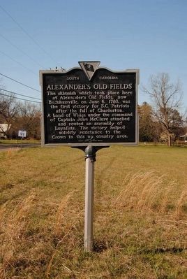
On Great Falls Highway (State Highway 97) at Chester Avenue (State Highway 99), on the left when traveling east on Great Falls Highway.
The skirmish which took place here at Alexander's Old Fields, now Beckhamville, on June 6, 1780, was the first victory for S.C. Patriots after the fall of Charleston. A band of Whigs under the command of Captain John McClure attacked and routed . . . — — Map (db m13688) HM
On Hopewell Church Road at Aiken Creek Road, on the left when traveling east on Hopewell Church Road.
In memory of
Burrel Hemphill
killed by
Union Soldiers
Feb. 1865
although a slave
he gave his life
rather than betray
a trust
He was a member of Hopewell — — Map (db m81337) HM
On State Highway 97 at Old Catholic Church Road, on the right when traveling east on State Highway 97.
Divergent Presbyterian groups held services in this area as early as 1759. Rev. William Richardson, active in the area, is credited with unifying and naming them in 1770. The cemetery contains many graves of Revolutionary and Confederate . . . — — Map (db m13687) HM
Near Old Catholic Church Road (County Route 355) 0.9 miles south of Great Falls Highway (South Carolina Route 97), on the right when traveling south.
Rev William Martin 1716-1806 •
Col. John Nixon 1780 Capt. John Steel 1750-1810 •
Capt. Hugh Knox 1755-1821 Capt. Benj. Land 1780 •
Robert Archer 1748-1818 John Corder •
William Anderson 1744-1780 John Lee 1760 •
John Bailey David McCalla . . . — — Map (db m245568) WM
Main Text
When people look for a home, one consideration is convenience to a grocery store. The bald eagles that nest here had something similar in mind: access to their favorite food - fish - in the Catawba River. When keen eyes on a handy . . . — — Map (db m95437) HM
Canal Trail (orange) This trail is an easy 1.25 miles one way, starting from either the Park Office parking or the south entrance parking area. Total round-trip time is about 2 hours. The trail follows Landsford Canal, which was built in the . . . — — Map (db m95432) HM
Near Park Drive near Landsford Road (South Carolina Highway 843), on the right when traveling north.
As a boat approached the canal traveling south on the Catawba River, the patroon, or river boat pilot, first saw the diversion dam. The dam consisted of piles of loose stone on the river bottom. The dam projected from the bank at roughly forty . . . — — Map (db m13722) HM
Landsford Canal is located along the banks of the Catawba River in the South Carolina Piedmont. Because this region sits atop a fall line, it features changes in elevation that produce shoals and rapids. In the 19th century, merchants bypassed . . . — — Map (db m95431) HM
On Main Street at Gadsden Street, on the right when traveling east on Main Street.
In 1806
Aaron Burr, while passing
through Chester a prisoner,
dismounted on this rock and
appealed in vain to the
citizens for help. — — Map (db m14273) HM
On Old Richburg Road (County Route 56) 0.6 miles east of Meador Road (County Route 74), on the right when traveling east.
Black Rock Baptist Church formally
organized by 1874 and was originally
part of the Gethsemane Baptist
Association. The church traces its
roots to the early ministry of its
first pastor, Leroy Featherstone
(c. 1836-1919), believed to . . . — — Map (db m278082) HM
The following jewelry stores have occupied the lower floor of this building; Brandts, Robinsons, Royals, & Runyans. The original clock tower has been removed. From 1820 to 1853, two courthouses (one wooden & one rock) stood in front. The town . . . — — Map (db m94952) HM
On Lancaster Street (State Highway 9) at Wilson Street, on the left when traveling east on Lancaster Street.
This institute grew out of an 1866 school for freedmen; it became Brainerd Institute in 1868 when the Board of Missions of the Presbyterian Church in New York appointed Rev. Samuel Loomis to help establish churches and schools among the blacks near . . . — — Map (db m14280) HM
On Gadsden Street (State Highway 72) at Main Street (State Highway 9), in the median on Gadsden Street.
[South Side]
C.S.A.
This monument guards the memory
of the men of Chester District
who obeying the call of their state
died for the Confederate cause.
U.D.C.
Time may crumble this marble into dust
but time can not dim their . . . — — Map (db m14269) WM
On Main Street (State Highway 72) 0.1 miles west of Wylie Street, on the left when traveling east.
This courthouse, built in 1852, was designed by Edward Brickell White (1802-1888) of Charleston, whose work was greatly influenced by Robert Mills. Additions by Alfred D. Gilchrist of Rock Hill in 1896 and 1928 included three-story rear wings and a . . . — — Map (db m14276) HM
Chester County's fifth courthouse replaced three others in the city & the first courthouse was located (1785-1791) at John Walker's House in the Lewis Community.
In 1928, the 3-story rear wings were added, & in 1975 interior renovation[s] . . . — — Map (db m94944) HM
On Main Street at Wylie Street, on the right when traveling south on Main Street.
Chester County's World War I Veterans
Manuel Able •
Robert L. Atkinson •
Israel Boyd •
Edmund Brown •
Walter Campbell •
King Castle •
William F. Cauthen •
William Chapple •
John R. Cockerell •
Ernest Coleman •
Claud Craig • . . . — — Map (db m292468) WM
The chief hotel, was in operation as early as 1835 & stood on this site. Other hotels have been located here. Portions of this building date as early as 1854. — — Map (db m94951) HM
Proudly we pay tribute to the
members of our organization who
answered the call to the colors
in World War II
Jake S. Colvin, Jr.
T.W. Barrett, Horace R. Harris
Charles M. Bell, Robert R. Ritchie
John A. Crosby, Dewey O. Snead . . . — — Map (db m94954) WM
About Chester State Park
Chester State Park has been a local haven for retreat and recreation since it was built by the men of the Civilian Conservation Corps in the late 1930s during the Great Depression. Nestled in 523 secluded acres . . . — — Map (db m94827) HM
Near Steele Village Road at Fishing Creek Church Road.
SC Militia under General Thomas Sumter
Justice of the Peace
Tax Inquirer & Collector
Member Committee of Elections
Member, 1st & 2nd Provincial Congresses
Member, General Assemblies — — Map (db m13767) HM
On Main Street (State Highway 72`), on the left when traveling north.
This War Between the States era cannon is one of four similar cannon discovered February 1986, on the grounds of Calvary Baptist Church, Chester, S.C. All four cannon were spiked with shells and each had the trunnions and cascabel knobs broken . . . — — Map (db m94942) HM
On Main Street (State Highway 72), on the left when traveling north.
This War Between the States era cannon is one of four similar cannon discovered February 1986, on the grounds of Calvary Baptist Church, Chester, S.C. All four cannon were spiked with shells and each had the trunnions and cascabel knobs broken . . . — — Map (db m94946) HM
On Caldwell Street at Crosby Street, on the right when traveling east on Caldwell Street.
Finley High School opened
In 1923. It was originally
known as Chester Colored
High School and located
¼ mi. N on McClure St.
In 1927 the school was
renamed in honor of its
founding principal Samuel
Louis Finley who came to
Chester in 1905 . . . — — Map (db m278081) HM
On Steele Village Road at Fishing Creek Church Road, on the right when traveling north on Steele Village Road.
Presbyterian church reportedly est. 1752. Present building, enclosed with brick in 1958, dates from 1785. Cemetery contains pioneer settlers and veterans of many wars. — — Map (db m121921) HM
On Gadsden Street at Main Street, on the right when traveling east on Gadsden Street.
Historic downtown Chester, established as the county seat in 1971, features the Confederate Monument, Cistern, Civil War Cannon, and Aaron Burr Rock landmarks. This area, listed on the National Register of Historic Places, still serves as a hub . . . — — Map (db m14267) HM
On West End Road (South Carolina Route 72/121) south of Carter Road ( Route 121), on the left when traveling east.
Old Zion Church formally organized by 1873. It was originally located 2 mi. E on Goings Rd. where it shared a cemetery with St. Paul Baptist Church. Around 1890, Old Zion moved to this site on land conveyed by Martha Wise to church trustees John . . . — — Map (db m292461) HM
Near Steele Village Road at Fishing Creek Church Road.
[Front Side]
In Memory of
The Reverend John Simpson
1740-1808
Wife
Mary Remer
1743-1812
Minister
Educator
Soldier
Patriot
Married 1765- New Jersey
Graduated Princeton College with high honors 1768
Studied . . . — — Map (db m13799) HM
On West End Road (State Highway 72/121) 0.4 miles east of Sandy River Road (State Road 42), on the left when traveling east.
St. Paul Baptist Church at Halsellville. This congregation, originally known as St. Paul Colored Baptist Church, was formally organized by 1884 on nearby Goings Road. The church moved to this location in 1901. Members acquired the land for . . . — — Map (db m246066) HM
On Main Street 0.1 miles west of Wylie Street, on the left.
Dedicated
November 11, 1932
to the memory of
the boys who entered the
service of their country
from Chester County
and who gave their lives
in the World War
Robert L. Atkinson • Walter . . . — — Map (db m14279) WM
Near Park Drive near Landsford Road ( Highway 843), on the right when traveling north.
At several points along its path, the canal crossed natural streams flowing toward the river. To avoid damage to the fragile canal bed, the streams were channeled under the canals through culverts. This arch culvert consisted of a wing wall on the . . . — — Map (db m13740) HM
Near Park Drive near Landsford Road ( Highway 843), on the right when traveling north.
Not far from the Guardlock, the canal passed under a wooden bridge. Cut stone abutments on each bank supported the simple wooden truss structure. This was the first of four bridges that crossed the canal on it two mile path beside the river. The . . . — — Map (db m13739) HM
Near Canal Road (State Highway 330) near Landsford Road (State Highway 843), on the right when traveling east.
The most heavily traveled road in Colonial America passed through here, linking areas from the Great Lakes to Augusta, GA. Laid on ancient animal and Native American Trading/ Warrior Paths. Indian treaties among the Governors of NY, PA, & VA and the . . . — — Map (db m13719) HM
On State Highway 9 at Morrison Road, on the right when traveling east on State Highway 9.
Two miles south, at Cedar Shoals on the south side of Fishing Creek, was the home of John Gaston, Esq., Justice of the Peace under both the Royal and State governments. Though advanced in years, he was the leading spirit in arousing resistance to . . . — — Map (db m13758) HM
On Catawba River Road (U.S. 21) at Landsford Road (State Highway 843), on the right when traveling north on Catawba River Road.
[Front Side]
Located about 4 mi. E., this ford, an early Indian crossing, was probably named for Thomas Land who received a nearby land grant from the Crown in 1775. Used by Patriot and British armies during the American Revolution. Later . . . — — Map (db m13757) HM
Near Park Drive near Landsford Road ( Highway 843), on the right when traveling north.
A vital link in South Carolina's internal improvements program of the 1820's, the canal stands as a monument to the following men who typified the South Carolina spirit during this first great era of public works building: William R. Davie, . . . — — Map (db m13720) HM
Near Park Drive near Landsford Road ( Highway 843), on the right when traveling north.
Near its halfway point, the canal passed the mill complex built by William Richardson Davie around 1810. This mill sawed lumber and ground grain, both by use of water power. A waste weir at the entrance to the complex regulated the level of water in . . . — — Map (db m13744) HM
Near Park Drive near Landsford Road ( Highway 843), on the right when traveling north.
It is this upper section of the canal that has best survived periodic flooding in tact. The canal bed is not always straight but curves in several places to follow the contour of a natural hill. By cutting into the hill along a constant level and . . . — — Map (db m13745) HM
Near Park Drive near Landsford Road ( Highway 843), on the right when traveling north.
During the Nineteenth Century the rivers of South Carolina Piedmont were notorious for flooding. This lock was used to safely lower boats into the canal when high river levels threatened to damage the banks and structures. During periods of normal . . . — — Map (db m13723) HM
On U.S. 21 at Waterview Drive, on the right when traveling north on U.S. 21.
At this site on August 18, 1780 General Thomas Sumter camped with captured booty and 800 men. He was surprised and defeated by Lt. Col. Tarleton and 160 soldiers. The disaster followed only two days General Gate's defeat by Lord Cornwallis at . . . — — Map (db m13690) HM
On Catawba Road (State Highway S-20-20) 0.4 miles east of Peay Ridge Road (State Highway S20-268), on the right when traveling east.
Here in 1780-81
was the British post
Rocky Mount
Unsuccessfully
attacked by
Gen. Sumter
Aug. 1, 1780.
Col. Andrew Neel
and 7 privates killed. — — Map (db m228191) HM WM
On Dearborn Street at Ballpark Road ( Road 585), on the right when traveling west on Dearborn Street.
An inspiring leader. A profound
teacher. Dynamic coach. Compassionate.
He strove simply and honestly to
prepare his students for the larger
battles and games of life.
Organized first football program 1925. Coached all boys sports. Won first . . . — — Map (db m253486) HM
On West End Road (State Highway 215) 0.5 miles west of Store Road, on the left when traveling east.
On the east side of Broad River by an old Indian fish dam, General Thomas Sumter's camp was attacked before dawn on November 9, 1780 by the British 63rd Regiment and a detachment of the Legion, led by Major James Wemyss. The American campfires . . . — — Map (db m13685) HM
On State Highway 909, on the right when traveling north.
Front The state of Pennsylvania authorized the “Thirteen Original Colonies Bicentennial Covered Wagon Train” as an official Bicentennial project. It was one of five such trains that traveled across the country to reach Valley . . . — — Map (db m55707) HM
Near North Main Street at Park Avenue ( Road 87), on the right when traveling north.
Engine No. 5 nicknamed The Dummy
built by H.K. Porter of Pittsburgh, PA.
0-4-OT type with Const No. 5980
in Nov. 1917 for Watertown arsenal in Mass.
Acquired by E&M Ry. in 1942 from dealer Birmingham Rail & Locomotive Co.
Edgemoor & . . . — — Map (db m253506) HM
On State Highway 9, on the right when traveling west.
Dedicated by resolution of the Commission in recognition of the work and service of Senator Wilbur G. Grant in making possible this Reservoir and water system, for the people of Chester County.
E.J. Fowler, Chairman; Robert H. King, Secretary; . . . — — Map (db m55723) HM
On U.S. 52 at Howard Lane, on the right when traveling south on U.S. 52.
Cash Homesite
About 100 yards east of here was the home of General Ellerbe Boggan Crawford Cash, widely known for his 1880 duel with challenger Colonel William M. Shannon, whom he killed. Subsequently, all officers of the state and members of . . . — — Map (db m28267) HM
(Front): Erected by Ladies Memorial Association To the memory of our Heroic Dead who fell at Cheraw during the War 1864 - 1865. (Left Side): Fallen but not dead! "They have crossed over the river And they rest in the shade of the . . . — — Map (db m46221) HM
On 2nd Street (U.S. 1) 0.1 miles south of Powe Street (U.S. 1), on the right when traveling north.
Organized in 1881, this Negro Presbyterian (USA) school was founded by the Rev. J.P. Crawford with support from Mrs. C.E. Coulter from whom it received its name. The Rev. G.W. Long was academy president from 1908 until 1943, and Coulter offered . . . — — Map (db m18197) HM
On Huger Street 0.1 miles north of McDonald Street, on the left when traveling north.
John Birks "Dizzy" Gillespie was born in a house on this site on Oct. 21, 1917. His family lived here until they moved to Philadelphia in 1935. A founder of modern jazz, Gillespie was an innovative trumpeter and bandleader known for his bent . . . — — Map (db m28273) HM
On Church Street at Front Street, on the left when traveling west on Church Street.
Front
Francis Asbury (1745-1816), pioneer bishop of American Methodism, came to Cheraw in 1785, on his first visit to S.C. Asbury had just been ordained a general superintendent at the first General Conference in Baltimore on December 27, . . . — — Map (db m46201) HM
On West Greene Street west of Jersey Street, on the right when traveling west.
Long H.S. was completed in
1955 and replaced Coulter
Academy as the primary
African American H.S. in
Cheraw. The school was
named in honor of Rev. G.W.
Long, Coulter's President
from 1908 until 1943. Mr.
Henry L. Marshall was the
first . . . — — Map (db m268631) HM
On Church Street at Front Street, on the right when traveling east on Church Street.
St. David's, authorized by the General Assembly in 1768, was the last parish established in colonial S.C. Said to be buried in its churchyard are soldiers of British forces occupying the Cheraws in 1780. The steeple and vestibule of this . . . — — Map (db m28270) HM
On Chestnut St. at Washington Street, on the right when traveling north on Chestnut St..
[Front]
This church, formally organized in 1867, had its origins in Cheraw Baptist Church, founded in 1837. Shortly after the Civil War 285 black members there received permission to organize a separate church. Rev. Wisdom London, the first . . . — — Map (db m28271) HM
On Front Street north of Kershaw Street, on the right when traveling north.
Robert Smalls School was
built in 1953 as a
segregated school for
African American students.
Construction was funded as
part of South Carolina’s
school equalization program.
While both white and black
schools were funded by this
program, . . . — — Map (db m268634) HM
On Church Street at Front Street, on the left when traveling west on Church Street.
Encamped at Cheraw Hills in the summer of 1780 during the American Revolutionary War.
The Fraser Highlanders were recruited in Scotland in 1775 by their Clan Chief Simon Fraser, Master of Lovat, to serve in the army of King George III. They . . . — — Map (db m54803) HM
(Front):
This Carpenter Gothic house was begun ca. 1858 for Aaron Austin (1831-1863) and his wife Margaret Jane Craig. Austin, a Northerner who settled in Chesterfield in the 1850s, was a lawyer and also a Chesterfield District magistrate. . . . — — Map (db m47435) HM
On West Main Street (Business State Highway 9) at Academy Street, on the left when traveling west on West Main Street.
(front)
The building that stands here once served as the Chesterfield Academy. The first Chesterfield Academy building was located nearer to downtown. Local tradition holds that the Union 20th Corps burned the school along with other . . . — — Map (db m113789) HM
On East Main Street at Green Street, on the right when traveling west on East Main Street.
Chesterfield County's first courthouse was built here soon after the county was established in 1785. The second courthouse on this site was built 1825-1829 from plans by architect Robert Mills, designer of the Washington Monument. According to local . . . — — Map (db m28327) HM
On West Main Street (Business State Highway 9) at Crescent Drive, on the right when traveling west on West Main Street.
Chesterfield High School, which stood here from 1908 to 1992, was the successor to Chesterfield Academy, an antebellum school burned by Federal troops in 1865. A new academy, built in 1889, later became Chesterfield School. By 1907 it has three . . . — — Map (db m113790) HM
On East Main Street (State Highway 9) at Scotch Road, on the right when traveling east on East Main Street.
(side 1)
This post office, built in 1937-38, is one of several New Deal-era post offices in S.C. designed by the Public Works Division of the U.S. Department of the Treasury. Its architecture, a restrained version of the Colonial Revival . . . — — Map (db m102634) HM
On East Main Street at Park Drive, on the right when traveling west on East Main Street.
[Front]:
First Secession Meeting, Chesterfield Courthouse.
Nov. 19, 1860.
Banner used on Secession Day.
[Rear]:
Dedicated by the U.D.C's of Chesterfield Co. to the brave men, devoted women and faithful slaves, . . . — — Map (db m28328) HM
On East Main Street at Green Street, on the right when traveling west on East Main Street.
[Front]:
This house, the oldest in Chesterfield, was built ca. 1798 for John Craig (1755-1839), veteran of the American Revolution, merchant and miller, and county official. Craig’s father Hugh moved his family from Ireland to Virginia in . . . — — Map (db m28329) HM
On East Main Street at Page Street, on the right when traveling west on East Main Street.
One of Chesterfield's earliest houses, the Wm. Duke Craig House, c.1820, stood here before it was moved in 1975. Craig (1845-1935), farmer and merchant, also owned nearby Craig's Grist Mill. He fought in the Civil War with the 21st Regiment, S.C. . . . — — Map (db m28330) HM
On West Pine Avenue at South Sixth Street, on the right when traveling west on West Pine Avenue.
This depot, built in 1914, was the second station built by the Seaboard Air Line Railway in McBee. The town, the most successful of those established along Seaboard's Columbia-to-Cheraw line after it was completed in 1900, grew so quickly that a new . . . — — Map (db m28265) HM
On State Highway 215 at Coleman Road, on the left when traveling south on State Highway 215.
Around 1840 an academy was established at this site by John Feaster, a noted landowner of this area, for the education of female and male students. By 1842, both academy building and a boarding house (dormitory)had been erected. Mr. Feaster, . . . — — Map (db m14396) HM
On State Highway 215 0.1 miles north of Fort Wagner Road, on the right when traveling south.
Site one mile east at
junction of Beaver Creek
and Reedy Branch
built in 1760 by
Hans Wagner
as a refuge from the
Cherokee Indians — — Map (db m14397) HM
On Landis Road 0.8 miles south of Highway 213, on the left when traveling south.
This two-story brick house was built by James Kincaid (1754-1801), Revolutionary War soldier, who came from Scotland in 1773 and acquired this land in 1775. It was completed according to his plans after his death by his son, William Kincaid . . . — — Map (db m14399) HM
On Monjicono Road (State Highway 213) 0.5 miles west of Landis Road, on the left when traveling west.
On May 9, 1803, the Associate Reformed Synod of the Carolinas was organized here at Ebenezer A.R.P. Church, built in 1788 by a congregation dating from colonial days. The rock wall was added in 1852. Damaged by Union troops in 1865, the church was . . . — — Map (db m121864) HM
On Camp Welfare Road 2.5 miles south of Wateree Road, on the right when traveling north.
[Front]
This camp ground, described by one journalist as "picturesque, rugged, simple, with an overhanging air of festivity," has hosted an annual camp meeting since 1876; slaves had worshipped here before the Civil War. The site was . . . — — Map (db m14613) HM
On State Highway 901 at Heritage Road, on the right when traveling north on State Highway 901.
Here lie buried many of the Scotch Irish pioneers, who, in 1772, under the leadership of the Rev. William Martin, founded one of the first Covenanter churches in upper South Carolina. — — Map (db m14506) HM
On Monticello Road (State Highway 215) 0.3 miles north of Baltic Circle, on the left when traveling north.
1700s
Settlement
1730 – Governor Robert Johnson encourages settlement of the backcountry
1745 – The Lyles family, some of the earliest settlers in the area, purchased land along both sides of the Broad River near Beaver . . . — — Map (db m159720) HM
On Monticello Road (State Highway 215) 0.3 miles north of Baltic Circle, on the left when traveling north.
Early Settlement and the Lyles Family
In 1745, the Lyles family, some of the earliest settlers in the area, established their holdings on both sides of the Broad River, close to the mouth of Beaver Creek. Brothers, Ephraim and John Lyles, . . . — — Map (db m159721) HM
On State Highway 213 at Jenkinsville Road, on the right when traveling north on State Highway 213.
Two miles west of here at Parr Shoals on Broad River is the first atomic nuclear power plant in the Southeast. In 1954, the Atomic Energy Act was amended to allow the construction of nuclear power plants by private industry. Built by Carolinas . . . — — Map (db m159687) HM
On Centerville Road (State Highway 20-67) at Park Road, on the left when traveling north on Centerville Road.
Site of five buildings 1897-1986. Enemies of church burned two, tornado destroyed one. 1994 marks 100 years of Mormon presence in this community. — — Map (db m14467) HM
On South Dogwood Drive at Ruff Street, on the right when traveling south on South Dogwood Drive.
During February 17-19, 1865, General P.G.T. Beauregard, with Wade Hampton's cavalry acting as rear guard, made his headquarters here, telegraphing General R.E. Lee in Virginia news of the evacuation of Columbia, 20 miles south, before retiring to . . . — — Map (db m14328) HM
On Monjicono Road (State Highway 213) 0.5 miles west of Jackson Creek Road, on the left when traveling west.
This early Greek Revival house, built about 1835, is notable for its central double-tiered pedimented portico and double end chimneys. It was named for the oak avenue leading up to it and the oak grove surrounding it. The Oaks was built for Richard . . . — — Map (db m14331) HM
On State Highway 34, on the left when traveling west.
¼ mile east stood the home of Thomas Woodward, prominent leader of the South Carolina Regulator Movement, 1768-1769. He was a member of the First Provincial Congress and a charter member of the Mt. Zion Society. As Captain of Rangers in 1775-76 he . . . — — Map (db m47445) HM
On State Highway 20-18 at Beth Circle, on the right when traveling north on State Highway 20-18.
On May 26, 1780, one of the first victories for the Patriots after the fall of Charleston took place 1½ miles east on Little River. A body of Tories gathering at a Baptist meeting house in Mobley's settlement were attacked and dispersed by a . . . — — Map (db m159636) HM
On Ashford Ferry Road (County Route 18), on the right when traveling north.
(Front):
Governor of S.C. (1850-1852), president of the 1852 Secession Convention, and signer of the Ordinance of Secession in 1860, John Means was born near here in 1812. A colonel in the 17th Regiment, S.C. Volunteers, CSA, he died Sept. . . . — — Map (db m47540) HM
On Washington Street at Zion Street, on the left when traveling east on Washington Street.
This Associate Reformed Presbyterian Church was incorporated in 1823. Early pastors were the Rev. James Lyle and the Rev. Thomas Ketchin, installed 1825 and 1844 respectively. The old cemetery, located at corner of Fairfield and Vanderhorst . . . — — Map (db m14321) HM
On Congress Street 0.1 miles north of Moultrie Street, on the right when traveling south.
Cathcart-Ketchin House. Richard Cathcart purchased this lot from John McMaster in 1829, and it is thought he built the present federal-style house shortly thereafter. The house has had a number of owners including Priscilla Ketchin, who . . . — — Map (db m14325) HM
On Congress Street close to Washington Street, on the left when traveling north.
Fairfield County. A center of activity in the Regulator movement to bring law and order to the backcountry, this area in 1769 was made part of Camden District under the Circuit Court Act. In 1775 it formed part of the District between the Broad . . . — — Map (db m47442) HM
Near Congress Street at Washington Street, on the right when traveling south.
This courthouse was built in 1822 by Wm. McCreight under the supervision of Robert Mills, South Carolina architect, then serving as Supt. of Public Works. Alterations and additions were made in 1844. It was renovated in 1939 with the addition of two . . . — — Map (db m14320) HM
On Congress Street 0.1 miles north of Palmer Street, on the right when traveling south.
Fairfield Institute. This grade school and normal institute for blacks was founded in 1869 during Reconstruction by the Northern Presbyterian Church. The Reverend Willard Richardson was principal. In 1880, one-hundred of its students were . . . — — Map (db m14463) HM
On Congress Street at College Street, on the left when traveling south on Congress Street.
First United Methodist Church was established in 1808 under the leadership of the Rev. James Jenkins, an early circuit-riding minister, and John Buchanan, a captain in the Revolution. Pioneer American Methodist bishop Francis Asbury visited here . . . — — Map (db m14284) HM
On Industrial Park Road (County Road 20-34) south of State Route 34, on the right when traveling south.
This is Hampton and Branchville #44. This locomotive was built in January of 1927 by the Baldwin locomotive works. she was built for the Hampton & Branchville Railroad, a shortline railroad located at Hampton, South Carolina. The 44 spent its entire . . . — — Map (db m292449) HM
On Industrial Park Road (State Road 20-34) south of State Route 34, on the right when traveling south.
For some background, all locomotives were required to have two methods of inserting water into the boiler, one of which being the feedwater heater, and the other being the injectors. Both methods were required to be independent from each other . . . — — Map (db m292448) HM
617 entries matched your criteria. The first 100 are listed above. Next 100 ⊳