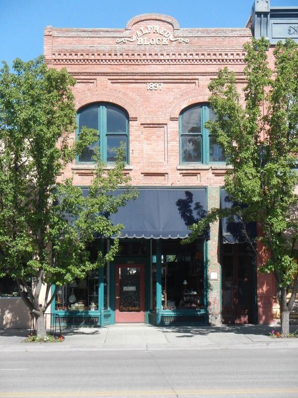
On Main Street (Oregon Route 7) near Valley Avenuee, on the right when traveling north.
Mary Alfred was one of Baker City’s pioneer businesswomen. She and here husband, Francis Alfred, came to Baker County in 1870. She had a millinery and mantua (robe) shop in her home. Mr. Alfred drove a stage between Baker City and La Grande. . . . — — Map (db m108053) HM
On Washington Street at 1st Street, on the left when traveling west on Washington Street.
In the early days of the 20th Century, the Antlers Hotel was a bustling three-story hotel which boasted a fine restaurant and bar. The hotel had an elevator. The upper corridors were naturally lighted by “light wells” and skylights.
In 1910, a . . . — — Map (db m108096) HM
Near Campbell Street near Sunridge Lane, on the right when traveling west.
In October 1861, a group of prospectors in search of the mythical Blue Bucket Mine, made camp on a creek six miles southwest of here. That evening, Henry Griffin discovered gold in the gulch which bears his name. That started a stampede which . . . — — Map (db m108152) HM
On Windmill Road near Campbell Street, on the left when traveling south.
Chinese were prominent working on railroads & gold mines in Baker County. The Baker City Chinatown was located by Powder River on Auburn Avenue where a Joss House was built in 1883. Chinese gardens on the east bank of Powder River between . . . — — Map (db m108158) HM
On 1st Street near Auburn Avenue when traveling north.
Baker City, the “Queen City of the Inland Empire” at the turn of the century, needed a City Hall that reflected the town’s eminence. The city fathers commissioned a bold and stately Renaissance Revival building. The structure is noted for its . . . — — Map (db m108191) HM
On Main Street (Oregon Route 7) at Broadway Street (U.S. 30), on the left when traveling north on Main Street.
Prominent local businessman William Pollman contracted to have the Baker Loan and Trust Building built in 1910, after a major fire destroyed another building on the site, along with two buildings to the south.
The building was designed by . . . — — Map (db m108043) HM
On Main Street (Oregon Route 7) at Broadway Street, on the left when traveling north on Main Street.
Basche-Sage Hardware Co. was one of Baker City’s largest firms for more than 100 years. The company began when Peter Basche purchased a Baker City tin shop in 1876. In 1888, Basche merged with the Sage and Grace hardware store. Stores were opened in . . . — — Map (db m108084) HM
On Main Street (Oregon Route 7) at Broadway Street, on the right when traveling north on Main Street.
The Bishop Building stands as a testament to the strength and durability of volcanic tuff, which was used to construct many of Baker City’s major buildings during the first decade of the 1900s. A fire gutted the building in 1940, but it remained . . . — — Map (db m108079) HM
On Windmill Road near Campbell Street, on the left when traveling south.
This Chinese prayer house was used to honor the departing spirits by burning incense and prayer papers. The prayer papers were brown paper with some million little pinholes & pushed through the alter window. In traditional Chinese religion the many . . . — — Map (db m108159) HM
On Main Street near Court Avenue when traveling north.
When constructed, this building was the third bank building to occupy this site. J.W. Virtue, a pioneer gold mining entrepreneur, built the first bank in 1873. It was the first stone building on Main Street. The building was ruined by a fire in . . . — — Map (db m108037) HM
On Valley Avenue near !st Street, on the left when traveling west.
The central two-story portion of their building was constructed in 1910. In the 1940s, single-story wings of reinforced concrete were added to both sides of the original structure.
In its early years, the building housed the Chas. I. Flynn and . . . — — Map (db m108102) HM
On Main Street (Oregon Route 7) near Washington Avenue, on the right when traveling north.
When Baker City reigned as the “Queen City of the Inland Empire,” the Geiser Grand Hotel was a jewel in her crown. Built in 1889, the hotel soon earned a reputation for offering the finest accommodations between Seattle and Salt Lake . . . — — Map (db m108065) HM
Near Main Street near Court Avenue, on the left when traveling north. Reported missing.
This building was one of Baker City’s first masonry structures when constructed about 1879. Solomon’s One Price Clothing House originally occupied the first floor of the north half of the building. By the 1990s, footware had been sold in the . . . — — Map (db m108211) HM
On Main Street (Oregon Route 7) at Church Street, on the right when traveling north on Main Street.
In October 1940 Gwilliam Brothers Bakery celebrated the business’s new building with a grand opening. Designed for high-volume bakery operations, the brick structure had a delivery truck garage in the rear and a large central oven set on a concrete . . . — — Map (db m108161) HM
On Main Street (Oregon Route 7) near Court Avenueu, on the right when traveling north.
Haskell was one of Baker City’s leading real estate developers of the late 1800s and early 1900s. He also engaged in many other pursuits.
He was born in 1850 in Ohio. At age 18, he went to Montana to become a miner. He later mined in Nevada, . . . — — Map (db m108064) HM
On Main Street near Valley Avenue, on the left when traveling north.
The lot which this building occupies was first the location of a wood frame structure housing the McCord Brothers blacksmith shop. In 1867, Dr. J.M. Boyd and John W. Wisdom leased the structure to open Baker City’s first drug store. Wisdom continued . . . — — Map (db m108041) HM
On Valley Avenue at 1st Street, on the right when traveling west on Valley Avenue.
John Jett’s stonemason’s skills are manifest in the inscription carved at the roof level of his building - “J.H. Jett Marble Works, 1901.”
The Jett Building was the first in Baker City of volcanic tuff construction. Ten commercial or . . . — — Map (db m108206) HM
On Main Street (Oregon Route 7) at Court Avenueu, on the right when traveling north on Main Street.
This site was the location of Baker City’s first brick hotel, the Cosmopolitan. The Rev. P. DeRoo, a Catholic priest who aquired (sic) extensive real estate interests, had the two-story building built in 1875. The hotel also served as the city’s . . . — — Map (db m108063) HM
On Main Street (Oregon Route 7) near Valley Avenuee, on the right when traveling north.
Mike Hoff, a “tonsorial artist” (barber) in Baker City in the 1890s, built this building for his business. After a few years, however, Hoff went into partnership with Valentine Bildner to open a saloon in the building.
During the . . . — — Map (db m108060) HM
On Main Street (Oregon Route 7) near Broadway Street, on the right when traveling north.
The Lynndale Building was constructed about 1890. The northernmost of the three first-floor bays was occupied by a saloon from the building's earliest days. The establishment first was named Henry the Fourth, then The Club. Later it became the . . . — — Map (db m108077) HM
On Main Street at Valley Avenuee, on the right when traveling north on Main Street.
The Mann Block, built in 1890, originally housed one of the many saloons located in this block during Baker City’s early, rowdy years. Like most of the establishments, the saloon operated on the first floor, with a bawdy house and gambling rooms . . . — — Map (db m108052) HM
On Resort Street at Broadway Street, on the right when traveling north on Resort Street.
“McCord’s Corner” contributed much to Baker City history.
S. (Syrenus) B. McCord was the first mayor of Baker City. City residents elected him to four terms, and he also served several terms as county treasurer.
In 1873, McCord . . . — — Map (db m108209) HM
On Washington Street near 1st Street, on the right when traveling west.
This building was the location in the 1920s of the Lew Brothers Tire Co., which later moved to Bridge Street. After the tire company relocated, the building was purchased by Glenn Miller, owner of Miller’s Lunch in the adjacent building to the east. . . . — — Map (db m108097) HM
Near Main Street (Oregon Route 7) at Washington Avenue, on the left when traveling north.
This stucco-over-clay block building was constructed in 1923 as a "temporary" structure after a fire destroyed another building on the site. A block store first occupied the building, then an ice cream parlor.
Glenn Miller, a local candy-maker, . . . — — Map (db m108162) HM
On Main Street (Oregon Route 7) near Court Avenueu, on the right when traveling north.
The Mint-Fox Building was constructed as two adjoining structures, the south half in 1888, the north in 1889. The buildings were erected by A.A. Houston, a local builder. Houston first rented the south building to two miners, Lorenzo Durkee and . . . — — Map (db m108061) HM
On Auburn Avenue at Bridge Street, on the right when traveling east on Auburn Avenue.
Dedicated to the memory of the intrepid pioneers who blazed the way over the Old Oregon Trail with the first covered wagons in 1843 and won an empire for the United States.
Erected by the American Legion
July 4, 1925 — — Map (db m108048) HM
On Dewey Avenue (Oregon Route 7) near Auburn Avenue, on the right when traveling north.
The Old Post Office building served as Baker City’s post office for 58 years, from completion of construction in 1910 until 1968, when the Post Office relocated to a new Federal Building a block to the south. The building also housed offices of the . . . — — Map (db m108042) HM
On 1st Street near Washington Avenue, on the right when traveling north.
Baker City at the beginning of the 20th Century was the hub for a vast area of commerce, including mining, agriculture and forest products. Merchandise flowed into the city for distribution to dozens of smaller communities. Likewise, business . . . — — Map (db m108194) HM
Near Oregon Route 86 near Oregon Trail, on the right when traveling west.
Of the 2170 miles of the Oregon Trail, approximately 300 miles of ruts remain. Swales created by thousands of wagon wheels and the trampling of draft animals are deep in some areas, shallow in other places. Much of the trail has disappeared due to . . . — — Map (db m108130) HM
On 1st Street at Court Avenueu, on the left when traveling north on 1st Street.
William Shoemaker, a partner in a Baker City wholesale grocery and grain business, built this building in 1906. Before moving to Baker City, Shoemaker had been in business at Rock Creek, a small community in north Baker Valley. He built and operated . . . — — Map (db m108103) HM
Early Oregon Trail emigrants crested the south flank of Flagstaff Hill and, with the Blue Mountains looming to the west, saw a solitary tree in the valley below. Called l’arbre seul (the lone tree) by French-Canadian fur trappers, this . . . — — Map (db m108122) HM
On Oregon Route 86 near Oregon Trail, on the right when traveling west.
Beginning in 1843, thousands of Oregon Trail emigrants trekked through this region toward new lives in the West. This epic journey indelibly etched the landscape with wagon ruts, such as those near by. When Henry Griffin, a prospector from . . . — — Map (db m108128) HM
On Main Street (Oregon Route 7) at Church Street, on the left when traveling north on Main Street.
In 1900, after a fire had destroyed a former wood frame hall, the Baker City Masonic Lodge erected a new brick temple.
The lodge hall occupied the second floor. The first floor originally was leased to the E.P. Voruz & Co. Home Furnishing Store . . . — — Map (db m108081) HM
Near Campbell Street near Sunridge Lane, on the right when traveling west.
Wagons and cattle of the Great Migration, led by Marcus Whitman in 1843, descended Sept. 25 into Lone Pine valley.
After nearly a month of travel over the hot dry Snake river plains from Fort Hall near Pocatello, Idaho, the cool climate and lush . . . — — Map (db m108157) HM
This building, constructed in the 1890s, was the location of the Smoke Shop for approximately 50 years. The Smoke Shop was a typical men’s gathering place of the period, offering tobacco, beverages, billiards and card games.
The first business . . . — — Map (db m108035) HM
On 1st Street near Washington Avenue, on the right when traveling north.
Hand-cranked telephones first rang in Baker City in 1889. Not until 1898, however, did a company succeed in establishing 24-hour, central exchange service. When inaugurated, the system had 40 subscribers and one operator on duty.
The first . . . — — Map (db m108195) HM
A moveable community for four to six months along the trail… the wagon encampment typically grouped into a circle, forming a temporary corral. Around the circle, tents and bedrolls provided the shelter for exhausted pioneers. A few guards kept an . . . — — Map (db m199177) HM
On Main Street near Court Avenue, on the left when traveling north.
This property, which consists of parts of two adjacent structures built in the 1880s, was the location of many Baker City businesses over the years. One of the first was Basche-Sage Hardware Co., which was to grow into one of the Northwest’s largest . . . — — Map (db m108039) HM
On Main Street (Oregon Route 7) near Valley Avenuee, on the left when traveling north.
A fire that started in a billiard hall destroyed all the structures on this block in 1886. Several property owners chose to rebuild, and four adjoining brick buildings were constructed the following year. This building was constructed for Messrs. . . . — — Map (db m108050) HM
On Valley Avenue at !st Street, on the left when traveling west on Valley Avenue.
A committee of civic-minded Baker City residents began meeting in 1911 to organize a fund-raising campaign to build a Young Men’s Christian Association building. The committee soon had secured pledges of more than $30,000.
Plans for the . . . — — Map (db m108098) HM
On Old U.S. 30 at Oxman Ranch Road, on the left when traveling west on Old U.S. 30.
This spot was famous in early days as Express Ranch an important relay station on the Umatilla-Boise Basin stage and freight route. It was also a favorite camping place for emigrants and teamsters. — — Map (db m108121) HM
On Forest Road 73 2.2 miles north of County Road 24, on the right when traveling north.
Center Panel:These Chinese Miners Must Have Felt Like Sysyphus Pushing a Large Rock Uphill Forever, as in Greek Mythology.
The backbreaking labor of stacking and re-stacking sixteen acres of rocks here at the Ah Hee . . . — — Map (db m106776) HM
On Forest Service Road 10 (County Road 24) 0.3 miles south of Federal Road 13, on the right when traveling west.
In the early 1880s, the Red Boy Vein was located and claimed by Daniel Pinson, a Cherokee Indian. The claim did not pan enough free gold to work without a mill. His only legacy is the mine's name.
In 1886 it became a paying proposition when . . . — — Map (db m106767) HM
Natural landforms gave local settlers an opportunity to shape history. As you explore the remains of the gold rush era, consider the partnership of people and nature.
A lake the ice forgot
When the Ice Age glaciers melted, they left . . . — — Map (db m106762) HM
On Whitney Tipton Highway (State Highway 7) near Forest Road 2620, on the left when traveling west.
Elevation 5100 Feet on the Sumpter Valley Railway
The war against winter snow was fought here with a wedge plow pushed by several engines. Rails had to be kept open to move logs to the sawmills. Rails were laid into Tipton Summit from Baker by . . . — — Map (db m284119) HM
On Front Street (La Grande-Baker Highway) near 4th Street, on the left when traveling north.
Here cattlemen loaded herds into boxcars bound for Portland; while cowboys and rustlers haunted saloons.
Railhead warehouses of the 1880's were town down in the 1990's and with salvaged materials the park project began.
With foresight and . . . — — Map (db m111276) HM
On Interstate 84 at milepost 293 near Medical Springs Highway (Chandler Lane) ( Route 203), on the right when traveling west.
(Six panels dealing with the Baker Valley portion of the Oregon Trail are found beneath this kiosk) Permanent Settlers
In 1861, Henry Griffin, a prospector from California discovered gold eight miles southwest of the present . . . — — Map (db m111284) HM
On Front Street (La Grande-Baker Highway) near 4, on the left when traveling south.
After the close of the Sioux and Piute Indian wars the ranchers of Wyoming and Montana, discouraged in their attempts to fatten the Texas longhorn, turned to Oregon for their cattle. During the spring cattlemen and their cowboys arrived daily from . . . — — Map (db m113516) HM
Near Front Street (La Grande-Baker Highway) near 4th Street, on the left when traveling north.
The first cabin known to have been built in Baker Co. in 1861. Moved from it's original site five miles south in 1993. Disassembled and reconstructed to depict the life of the Oregon Trail Pioneers upon settling in the valley.
Donated to the . . . — — Map (db m111278) HM
Near Oregon Trail Boulevard (Business U.S. 30) near Frontage Road, on the right when traveling north.
The last camp on the weary journey across the Snake River plains. Here the Oregon Trail left the Snake River and wound overland to the Columbia. Here camped Wilson Price Hunt, December 23, 1811; Capt. Bonneville, January 10, 1834; Nathaniel J. . . . — — Map (db m107217) HM
Near Huntington Highway (Business U.S. 30) near Interstate 84, on the right when traveling north.
(The Farewell Bend Oregon Trail kiosk houses seven panels which deal with the trials and tribulations on this arid portion of the Oregon Trail.)
"Pathway to the "Garden of the World"
Excitement filled the air May 22, . . . — — Map (db m107276) HM
On Lockett Road near Vietnam Veterans Memorial Highway (Interstate 84), on the right when traveling south.
From Alkali Springs, called by many pioneers Sulphur Springs, the emigrants traveled on to Birch Creek, which offered much needed water and grass for their livestock. First named "Riviere aux Bouleaux" by French-Canadian fur trappers, here travelers . . . — — Map (db m107212) HM
On Washinton Street East (Business U.S. 30) near 1st Street East, on the right when traveling west.
To reach Oregon, Union Pacific Railroad organized the Oregon Short Line Railway Co. in 1881 and built from Wyoming westward across Idaho in the same year. Oregon Railway & Navigation Co. was building eastward from Portland. Tracks of the two . . . — — Map (db m107282) HM
On Oregon Trail Boulevard (Business U.S. 30) near Frontage Road, on the left when traveling north.
In October 1860 the Van Ornum Party, survivors of the Utter Disaster, reached Farewell Bend. Here they again encountered Indians.
On September 9 & 10, in Idaho, the Elijah P. Utter wagon train suffered a two-day attack by Indians in . . . — — Map (db m107219) HM
On Oregon Trail Boulevard (Business U.S. 30) when traveling north.
By October 1860 the Van Ornum party reached Farewell Bend. They were survivors of the Elijah P. Utter wagon train that was attacked by Indians on September 9 and 10, just west of Castle Butte in Owyhee County, Idaho. The survivors had escaped the . . . — — Map (db m107220) HM
On Washinton Street East (Business U.S. 30) near 1st Street East.
By October 1860 the Van Ornum party reached Farewell Bend. They were survivors of the Elijah P. Utter wagon train that was attacked by Indians on September 9 and 10, just west of Castle Butte in Owyhee County, Idaho. The survivors had escaped the . . . — — Map (db m107292) HM
On Austin Street 0.1 miles west of Mill Street, on the right when traveling west.
Welcome to the historic world of Sumpter Valley Dredge State Heritage Area! Here you will find one of the largest gold dredges in the United States.
There are many ways to learn about the dredge and the people who worked it, from tours to . . . — — Map (db m106794) HM
Near Austin Street near Mill Street, on the right when traveling south.
As you drove here, you probably saw long rows of rocks all over the valley. These are tailings - topsoil , riverbed rock, and bedrock, left behind by 40 years of dredging.
Because of the dredges' systematic destruction, the original meadow and . . . — — Map (db m111243) HM
The dredge is a huge but simple machine for mining an ancient river bed for gold. It is an expensive, powerful improvement on the shovel and rocker box.
Miners used to call the dredge a "goose"---and for good reason. The dredge is "fed" at the . . . — — Map (db m106890) HM
Near Austin Street near Mill Street (County Route 410), on the right when traveling south.
As you look at the tailings in an aerial photograph or along the road, you'll see that they're played out in neat lines. Why are they straight? Because the dredge had an "anchor" to keep it going forward in a line, rather than wandering over the . . . — — Map (db m111245) HM
The dredge floated in about nine feet of water- but it could move anywhere it wanted in the valley because it took its pond with it.
Hard to imagine, isn't it? It worked because the dredge dug a pond for itself to float in as it moved -- . . . — — Map (db m106871) HM
On Mill Street (County Route 410) near Sumpter Street, on the right when traveling north.
Bank was established in 1899 with a capital stock of $10,000.00. The first officers were A.P. Goss, President and A.H. Goss, Cashier. The bank was destroyed by fire on August 13, 1917 and the vault is all that remains. — — Map (db m111241) HM
On Mill Street at Sumpter Highway ( Route 410), on the right when traveling north on Mill Street.
The bustling boom town of Sumpter stretched from here westward to Powder River at the peak of the mining boom.
The mining camp was named for Fort Sumter, South Carolina, by five ex-Confederate soldiers who discovered gold near here in 1862. . . . — — Map (db m112914) HM
Near Interstate 84 near Gate Road/Sisley Creek Road, on the right when traveling north.
(Six panels dealing with the Burnt River portion of the Oregon Trail are found beneath this kiosk)
Dear Little Willie
Emigration on the Oregon Trail peaked in 1852 with 10,000 would-be Oregonians. Poor sanitation and . . . — — Map (db m108110) HM
On North Fork Burnt River Road (County Road 529) south of Whitney Tipton Road (State Route 7), on the right when traveling south.
Rails of the Sumpter Valley RR reached Whitney Valley June 1, 1901. Originally a lumber company town, Whitney grew to become the main head of stage lines to mining and cattle towns such as Unity, Bridgeport, and Malheur City. Logging railroads were . . . — — Map (db m284118) HM
On Beech Street at Locust Street, on the right when traveling west on Beech Street.
(Seven panels dealing with the Columbia Plateau and Columbia River portions of the Oregon Trail are found at this kiosk)
Pathway to the "Garden of the World"
Excitement filled the air May 22, 1843 as nearly one thousand Americans left . . . — — Map (db m111946) HM
On Oregon Route 19 0.4 miles south of Montague Lane, on the right when traveling south.
Who followed this route across the plains at the age of 17 driving oxen and walking barefoot.
He later settled on Shuttler Flat five miles south of this marker and was the first to engage in wheat farming in Gilliam County — — Map (db m101983) HM
On Up Middle Fork Road (County Highway 20), on the right when traveling west.
There are five markers describing the areaMarker 1:
A history of human interaction with the land
From tribal use to ranching, gold mining, and ecological restoration, the land that is now the Oxbow Conservation Area . . . — — Map (db m107488) HM
On Boot Hill Road, on the left when traveling west.
There are four graves, that of two women and two men. We do not have records of their time of passing, their names, or their individual location within this enclosure, but assume it to be during the gold rush days of 1862-1880. We also do not know . . . — — Map (db m107538) HM
On Park Street at Highway 395, on the right when traveling east on Park Street.
Gold was discovered on Whiskey Flat in June, 1862; Canyon City quickly grew and became the County Seat by 1864. Scenes and Characters from the early years come alive in this 1996 mural by Larry Kangas.
This colorful history is celebrated at "62 . . . — — Map (db m96719) HM
On South Washington Street at Park Street, on the left when traveling south on South Washington Street.
In June 1862, a company of miners from northern California were heading east over the Strawberry Mountain Range, when one of the men discovered gold on Whiskey Flat, half a mile south of here. Miners from all over the area flocked into the area, and . . . — — Map (db m96722) HM
Near John Day Highway (Oregon Route 19) 2 miles north of U.S. 26, on the left when traveling north.
“What is it that urges a man to risk his life in these precipitous fossil beds? I can answer only for myself, but with me there were two motives, the desire to add to human knowledge, which has been a great motive all my life, and the . . . — — Map (db m114115) HM
This haystack was built on-site from mail order hardware and locally-milled lumber. A hay buck was used to push hay onto the fork. Horses pulling a cable attached to the fork life the load. Tripping a lever near the base released the hay. — — Map (db m158014) HM
On State Highway 19 near U.S. 26, on the right when traveling north.
James and Elizabeth Cant purchased this property in 1910. Over the following five decades they built the ranch before you. The methods used by the Cants in their early operations were replaced with more modern machinery and techniques as they . . . — — Map (db m158007) HM
Near State Highway 19 near U.S. 26, on the right when traveling north.
The Cant Ranch is one of the best-preserved examples of early 20th century ranching operations in the John Day River Valley. The ranch spans three historic development eras: The Officer Homestead Era (1890-1909); the Cant Sheep Ranch Era . . . — — Map (db m158010) HM
Near State Highway 19 near U.S. 26, on the right when traveling north.
Water, the lifeblood of any working ranch, flows in irrigation ditches fed by rivers, creeks, or a steady spring or two. In this dry landscape, these human-made arteries, like the one before you, have made the rich soils of the flood plain . . . — — Map (db m158011) HM
Marker 1 Shows an overview map of the National Monument with other points of interest.
Marker 2 Like Icing on a Cake. "Between 16.6 million and 15 million years ago, eastern Oregon sat above the nascent Yellowstone hot spot's . . . — — Map (db m108677) HM
Near State Highway 19 near U.S. 26, on the left when traveling north.
The Cant family's touring car might have traveled this trail route frequently. Before highway improvements were made in the 1930s, the trail on which you are standing is a remnant of the historic fabric that makes up this spot, a clue to the way its . . . — — Map (db m158008) HM
On Oregon Route 19 0.2 miles north of U.S. 26, on the left when traveling north.
The dark layers of Picture Gorge were formed from seventeen distinct floods of lava flowing from nearby cracks in the earth. These basalt flows joined with others covering much of eastern Washington and Oregon, and northern Idaho, beginning about 16 . . . — — Map (db m71521)
For most of the year, this platform sat empty and quiet. For two or three weeks in the spring, however, this small space bustled with bawling sheep, sweaty workmen, and grinding machinery.
Each of the ten workstations was supplied with . . . — — Map (db m158070) HM
Near Oregon Route 19 near U.S. 26, on the right when traveling north.
After the sheep were sheared, they went to pasture for the summer, typically a grazing allotment on one of the national forests. Herders trailed the sheep to and from the allotment on foot with the help of skilled dogs, a trip that could take as . . . — — Map (db m158067) HM
Near Oregon Route 19 near U.S. 25, on the right when traveling north.
You are standing in the middle of a lively watershed. Supporting a diverse community of aquatic and terrestrial life, the John Day River is the longest free-flowing river west of the Rocky Mountains, flowing over 280 miles to its mouth at the . . . — — Map (db m158071) HM
Near Oregon Route 19 near U.S. 26, on the right when traveling north.
Wool bag stand and bag from the Trosper Ranch near Antone, OR, about 1900.
At shearing time each spring, wool freshly sheared was packed in burlap bags for shipment. The cut wool was tossed into the bag. A person, usually a youth, was inside the . . . — — Map (db m158068) HM
On West Center Street at Forest Road 73, on the right when traveling east on West Center Street.
Side A:
Granite, Oregon
Albert G. Tabor first struck gold just below the town of Granite on the Fourth of July, 1862. Tabor named his claim the Independence since his strike was made on Independence Day, and the town that sprang up . . . — — Map (db m106791) HM
On Bremner Pass Road near West Main Street ( Route 26), on the right when traveling west.
The CCC was created in 1933 to provide young men useful work during the Depression. Camp Canyon Creek (Company 1231) was established in 1937. The CCC built numerous facilities such as District offices, the John Day Compound, fire guard stations, . . . — — Map (db m107548) HM
On Northwest Bridge Street just north of West Main Street (U.S. 26), on the right when traveling north.
The mining camp town of Canyon City sprang up soon after the discovery of gold in Canyon Creek in 1861 (Note: actually June of 1862).
When Grant County was formed in 1864 Canyon City became the county seat. Meanwhile, "Lower Town" . . . — — Map (db m107547) HM
Near Ing-Hay Way north of NW Canton Street, on the left when traveling north.
Has Been Designated a
National Historic Landmark
This property possesses national significance
in commemorating the history of the
United States of America
Kam Wah Chung Company Building is the best and earliest known . . . — — Map (db m112884) HM
On West Main Street (U.S. 26) east of NW Bridge Street, on the left when traveling east.
This church was built in the late 1890s by an Advent Christian minister. Dedicated in 1900, it was used for worship until the 1930s.
After this congregation disbanded, the church was vacant for several years. During the early 1940s the . . . — — Map (db m114109) HM
On U.S. 26 at Bridge Street, on the right when traveling west on U.S. 26.
Upper Marker:
This church was built in the late 1890s by an Advent Christian minister. Dedicated in 1900 it was used for worship until the 1930s. After this congregation disbanded, the church was vacant for several years. During the . . . — — Map (db m107546) HM
Welcome to Kam Wah Chung
In 1890 you would be standing in the middle of a bustling Chinatown.Businesses and homes all around you, the temple in front, and Kam Wah Chung- the core of the community- would be to your left. Why is it the only . . . — — Map (db m112887) HM
Elevation 5000 feet Surface 50 acres
Depth 98 feet.
Magone Lake was formed in the early 1800s by a landslide which dammed Lake Creek. Notice the tilted trees which rode down with the slide.
The lake was named for "Major" Magone and . . . — — Map (db m107489) HM
Near South Main Street, on the left when traveling south.
As better roads were built into the area, the need for the railroad diminished. The last run was made in 1947. The rails were removed and equipment was sold or scrapped. Some portions were widened and became roads, while the rest was gradually . . . — — Map (db m284120) HM
On John Day Highway (U.S. 26), on the right when traveling east.
Imagine the American Indians first creating trails through these mountains hundreds of years ago. Later, in 1825 and 1826, Hudson Bay Fur Company trappers, led by Peter Skeene Ogden, crossed this very pass. In 1862 more people made this difficult . . . — — Map (db m107101) HM
Near South Main Street, on the left when traveling south.
To conquer the rugged mountains and canyons, builders of the Sumpter Valley Railway resorted to a number of special engineering techniques. Steep grades of up to 4%, twice as steep as normally used on railroads, were numerous. Deep cuts were . . . — — Map (db m284122) HM
On 4th Street at Barnes Street (U.S. 395), on the left when traveling west on 4th Street.
For the longest time life here in Bear Valley as quiet and change was slow.
Native American seasonal camps gave way to small ranching operations of the first Europeans. In good weather the stagecoach ran through the valley. And in 1895, . . . — — Map (db m108734) HM
On Barnes Avenue (U.S. 395), on the right when traveling south.
After spending a day skidding logs, laying track or building Seneca's first homes, the workers needed a place to call home; temporarily at least.
In 1928 "Camp One" was established southwest of here, and with boxcars for homes, . . . — — Map (db m108735) HM
Back in the early 1920's you may have left the dirt streets and wooden sidewalks of the town of Burns, to walk in these woods, where untouched ponderosa stood tall.
But in a few short years, one of the biggest ever timber sales in the . . . — — Map (db m108836) HM
When the railroad was being built the forest here was a busy place with trees being felled to make ties, and rock being blasted for ballast. In February 1927, forest ranger G. C. Blake reported:
"Yesterday I made the trip from . . . — — Map (db m108872) HM
301 entries matched your criteria. The first 100 are listed above. Next 100 ⊳