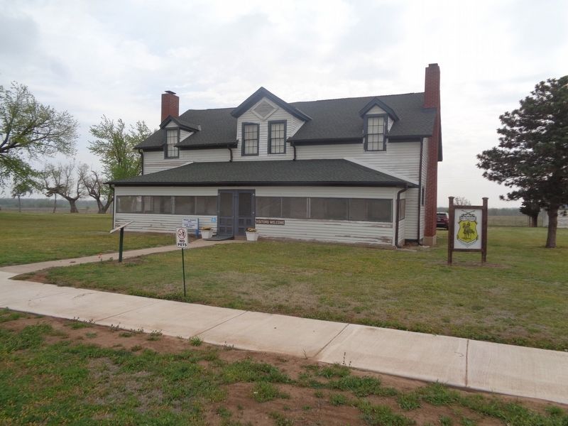
This duplex, erected in 1876, served as the home of married officers and their families until Fort Reno was decommissioned in 1948. There were 3 bedrooms and a maid's room upstairs, and a parlor, front room, kitchen, and front porch on the ground . . . — — Map (db m171132) HM
This Adjutant Office you see before you today is not actually the originally which was built of wood and served as Post Headquarters & Officer Quarters for 51 years. This structure, constructed of low fired brick and faced with concrete. In 1939, . . . — — Map (db m171129) HM
On East Woodson Street at North Rock Island Avenue, on the right when traveling west on East Woodson Street.
In honor of those citizens of Canadian County who served their country during the World War 1914-1918
They served without thought of self. That the principles of liberty, justice and equality might prevail for all mankind.
On the three . . . — — Map (db m267922) WM
During World War II, an eastern portion of the Fort Reno lands served as an internment work camp for German & Italian Prisoners of War. Mostly from Gen. Rommel's Afrikakorp, captured in North Africa, over 1,300 Germans were brought to Fort Reno by . . . — — Map (db m171128) HM
The Commander's Quarters was constructed in 1876. This building underwent major renovations during the WPA period in the late 1930's. Last remodeled in 2014, the building is home to BlueSTEM AgriLearning Center. This STEM (science, technology, . . . — — Map (db m171131) HM
On U.S. 81 0.2 miles north of Hefner Rd NE, on the right when traveling north.
Cheyenne-Arapaho Agency established there 1870, by Brinton Darlington, Quaker Indian agent appointed by President Grant. Important stop on Chisholm Trail, site of Arapaho School, John H. Seger, Supt. Post Office established in 1873, and first . . . — — Map (db m284688) HM
On Business U.S. 66, on the right when traveling west.
U.S. troops encamped near Cheyenne Agency in Indian uprising 1874. Site s.w. of agency selected by Agt. J.D. Miles and Capt T. Wint, established as permanent post in July, 1875, and named for Gen. Jesse L. Reno who died in action in Battle of . . . — — Map (db m39808) HM
In 1868, after several years of chasing the Plains Indians in the summertime, with no success, General Sherman developed the idea of a winter campaign. Severe winter weather made all Tribes less mobile. Sherman selected General Sheridan and Col. . . . — — Map (db m171122) HM
The Fort Reno Commissary is a 234-foot-long, 16,300 square foot building. It was constructed in three parts. The center section was built in 1885. The north and south sections were added in 1886. Supply trains and freight wagons brought food and . . . — — Map (db m171125) HM
The Guard House, also known as a jail, was constructed in 1888 of native stone from a quarry located about 6 miles west of here. Many windows still have the bolts imbedded where iron bars were held in place. An annex was added to the west side of . . . — — Map (db m171127) HM
Originally built in the late 1930's to serve as officer's barracks, then turned into a hospital in the mid 1940's, this building now serves as the Administration Building for USDA ARS Grazinglands Research Laboratory (GRL). GRL develops and delivers . . . — — Map (db m171124) HM
On US-81 (U.S. 81) at 164th Street Northwest, on the right when traveling south on US-81.
Mennonites settled in this area soon after Oklahoma territory opened by run April 22, 1889. Their first mission activity was among Indians. This colony was southernmost for Mennonites along Chisholm Trail. Farmers of Swiss (from Berne, Ind.), . . . — — Map (db m186333) HM
On Sunset Drive at South Bickford Avenue, on the right when traveling west on Sunset Drive.
El Reno namesake born in Wheeling, West Virginia. Reno was a 1846 graduate of West Point Military and thrice decorated hero of 1846 war with Mexico. He was promoted to Brigadier General at the start of the Civil War. Reno is credited with saving the . . . — — Map (db m56899) HM
On Wade Street (U.S. 66) at South Choctaw Avenue (U.S. 66), on the left when traveling east on Wade Street.
Introduced in the 1920s,
shredded onions fused with
limited amounts of ground
beef made these burgers an
affordable local specialty. — — Map (db m274223) HM
Ben Clark, more than any other man in the history of Western Oklahoma, can be identified with the history of Fort Reno. He was one of the interpreters at the signing of the treaty at Medicine Lodge, KS in 1867. He was with Cavalry Commander . . . — — Map (db m171123) HM
The western branch of the Chisholm Trail passed less than one mile east of this location on its way to the Darlington Indian Agency located about a mile to the northeast. Fort Reno thus became an important resupply location for the drovers and herds . . . — — Map (db m171121) HM
On South Evans Avenue south of West Watts Street, on the left when traveling north.
The home was built in 1900-1901, by William and Magdalen Goff. Mr. Goff came to El Reno, in 1892, to work for Anheuser and Busch. He soon became an agent for the firm, later he started Goff Bottling Works and organized the Goff Cadet Band.
The . . . — — Map (db m171134) HM
This Victorian style house was built in 1891 and used as Officer Quarters. It has three stories plus a basement. The foundation is stone with load-bearing brick on the lower floor. The second and third floors are a wood frame constructed with . . . — — Map (db m171130) HM
On North Czech Hall Road at Silver Maple Drive, on the right when traveling south on North Czech Hall Road.
Established in 1899 by early Czech settlers who were members of Sokol Karel Havliček Lodge and Western Fraternal Life Association Lodge Jan Žižka No. 67. Original structure replaced in 1925. Focal point of Czech, social and musical functions in . . . — — Map (db m56898) HM
On Jim Watson Drive at South Holley Avenue, on the right when traveling north on Jim Watson Drive.
A.N. Spencer, founder of Yukon, drove his cattle up the Chisholm Trail from Texas several times. Spencer bought land from Mrs. Taylor, Luther Morrison, and Joseph Carson to start Yukon. He persuaded the Choctaw, Oklahoma, and Gulf railroad to change . . . — — Map (db m297295) HM
On U.S. 77 at North Main Street, on the right when traveling north on U.S. 77.
One mile northwest the Camp Holmes Treaty was signed to guarantee peace, friendship, good hunting, safe travel, as far as the western borders of the U.S.A. To negotiate their first treaty with our government and the Civilized Indian Nations, 5000 . . . — — Map (db m144841) HM
On 89er Park Street at U.S. 77, on the left when traveling east on 89er Park Street.
Birthplace & Boyhood Home
Col. John L. Smith Dec. 26, 1914 - June 10, 1972
Col. John Lucien Smith U.S.M.C. In 54 days of aerial combat in the Solomon Islands he destroyed 19 Japanese planes to become the leading air ace of World War II at that . . . — — Map (db m144843) HM WM
On James C. Nance Memorial Bridge (U.S. 77) 0.1 miles west of Southwest 5th Street, on the left when traveling west.
The Billy Hocker Bridge, pictured above, was the first across the Canadian connecting
Lexington and Purcell. It opened for traffic on September 29, 1899, and quickly became a
vital transportation link. A 24 hour crossing, it was not unusual for up . . . — — Map (db m276533) HM
On U.S. 77 at '89er Park Street, on the right when traveling north on U.S. 77.
Canadian River was south line of “Old Oklahoma” opened by Run at 12 o’clock noon, April 22, 1889. Riders started at river crossing near here. Many thousands entered the 2,000,000 a. tract north: homes were planted and tent cities . . . — — Map (db m144698) HM
On Main Street (U.S. 77) 0.1 miles north of South 8th Street, on the right when traveling north.
In 1843, General Zachary Taylor sent
Capt. Nathan Boone, youngest son of
Daniel Boone, with a complement of
nearly 100 men and officers to reconnoiter the Plains Indian tribes.
On their return march they camped
July 20, on creek east of this . . . — — Map (db m276576) HM
On East Main Street at North Jones Avenue, on the left when traveling east on East Main Street.
In the early to mid-decades of the 1900s, this historical clock was a prominent fixture of the exterior of the First National Bank, 132 East Main. The clock was not part of the original design of the bank and probably was added to the building in . . . — — Map (db m279743) HM
On College Avenue north of Elmwood Drive, on the right when traveling north.
Psi Chapter of Alpha Chi Omega was established at the University of Oklahoma with twelve founding members on January 14, 1916. On that date, Alpha Chi Omega became the fifth national sorority on the university's campus. Additionally, Psi became the . . . — — Map (db m278157) HM
On East Main Street west of South Peters Avenue, on the right when traveling east.
The city's first brick building, constructed by Pryor V. Adkins on his lot at 101 E. Main Street in 1890, was home to many businesses before it was demolished to make way for the construction and opening of the Sooner Theatre in 1927. Mr. Adkins . . . — — Map (db m279588) HM
On East Main Street at North Peters Avenue, on the left when traveling east on East Main Street.
Nearly all of the wooden buildings on the south side of Main Street in the first block east of the railroad tracks were destroyed by a massive fire in the summer of 1902. It was believed to be the city's worst fire.
The easternmost buildings, . . . — — Map (db m279615) HM
On East Main Street at North Peters Avenue, on the left when traveling east on East Main Street.
Although there was no money to grade and drag Norman's Main Street for the first few years, there were wooden sidewalks within eight months of the town's settling in 1889. In summer months, a municipal sprinkling system was activated to keep the . . . — — Map (db m279611) HM
On East Main Street at South Peters Avenue, on the right when traveling east on East Main Street.
C.W. Streeter opened Norman's first shoe and boot store in front of his home at 209 E. Main. Downtown Norman's support of movie theaters from the 1930s through the 1970s was evident in the 200 block of East Main Street. The north side of the street . . . — — Map (db m279603) HM
On East Main Street at North Jones Avenue, on the left when traveling east on East Main Street.
The Land Run of April 22, 1889, brought tens of thousands of settlers to the Unassigned Lands of the Indian Territory, in what is present-day central Oklahoma. Norman was founded on that day and its new residents brought a demand for all types of . . . — — Map (db m279748) HM
On Legacy Park Drive west of 24th Avenue Northwest.
After the bombing of Pearl Harbor in December of 1941, the U.S. entered World War II and the Navy began looking for sites to train fighter pilots. The Navy bought 2,537 acres in Norman and leased another 62,000 acres in Oklahoma, primarily for . . . — — Map (db m279886) HM
Near South Jones Avenue near East Symmes Street, on the right when traveling south.
Although the second decade of the university's existence was marked by solid advances in important areas, the prevailing notes were of tragedy, turmoil and political interference. On the positive side, the institution experience gratifying growth. . . . — — Map (db m279121) HM
Near Parrington Oval south of West Boyd Street, on the right when traveling north.
This peaceful garden is named in honor of Ada Lois Sipuel Fisher. Despite state laws in Oklahoma and sixteen other states mandating racially segregated education, she was quietly determined to secure the advantages of higher education for herself . . . — — Map (db m278427) HM
On West Brooks Street 0.1 miles west of Jenkins Avenue, on the right when traveling west.
This building is named for Arthur Barto Adams, the first dean of the College of Business Administration. Adams was born in Union County, South Carolina on January 24, 1887, and studied at the University of South Carolina and at Columbia. He came to . . . — — Map (db m277498) HM
On College Avenue south of Emerald Way, on the right when traveling south.
On April 2, 1921, the Oklahoma Delta Kappa Chapter of Alpha Tau Omega Fraternity began by initiating 27 men of the University of Oklahoma. In 2021, Delta Kappa celebrates its centennial as a leading chapter both nationally and at OU. From its first . . . — — Map (db m278163) HM
On Elm Avenue at West Brooks Street, on the right when traveling south on Elm Avenue.
Zarrow Hall is named in honor of Henry Zarrow, a lifelong philanthropist, and his wife, Anne, who shared a passion for helping others. This building was dedicated in 2011 and houses the School of Social Work. It reflects the traditional architecture . . . — — Map (db m278103) HM
Near Parrington Oval 0.1 miles south of West Boyd Street, on the right when traveling south.
In 1893, three years after the First Legislative Assembly of the Oklahoma Territory established the University of Oklahoma, the first building On campus was completed. It was the first physical evidence of President David Ross Boyd's effort to build . . . — — Map (db m278502) HM
On West Brooks Street at Van Vleet Oval, on the left when traveling east on West Brooks Street.
This library honors William Bennett Bizzell (1876-1944), the University's fifth president. Born in Texas, Bizzell received a total of seven degrees from Baylor University, The Illinois College of Law, the University of Chicago, and Columbia . . . — — Map (db m277534) HM
On East Brooks Street at South Jenkins Avenue, on the right when traveling east on East Brooks Street.
This part of the campus is named in honor of Stratton Duluth Brooks (1869-1949). Brooks was born in Everett, Missouri, grew up in Michigan, and studied at the Michigan State Normal School and at Harvard. He served as the superintendent of schools in . . . — — Map (db m277266) HM
Near Asp Avenue at Kuhlman Court, on the left when traveling west.
This building is named in honor of James S. Buchanan, fourth president of the University. Buchanan was born on October 14, 1864 in Franklin, Tennessee, not far from the Civil War battle that was engaged there at the time. He graduated from . . . — — Map (db m278454) HM
On Elm Avenue 0.1 miles south of West Boyd Street, on the right when traveling south.
This building was added to campus in 1932 to house the School of Home Economics and was named for the long time director of the school, Dr. Helen B. Burton. Dr. Burton was born in Chicago, Illinois on January 7, 1889. She studied at Indiana . . . — — Map (db m278091) HM
Near Griffin Community Park's entrance road 0.1 miles north of East Robinson Street, on the left when traveling north.
Dozens of Oklahomans boarded a train in Jacksonville, Ill., one day in 1895. They were bound for the prairie town of Norman, Oklahoma, and the newly opened private sanitarium that would care for them. That was the beginning of what is now known as . . . — — Map (db m279865) HM
Near Parrington Oval 0.1 miles south of West Boyd Street, on the right when traveling east.
This building is named in honor of the American philanthropist Andrew Carnegie (1835-1919). Following the burning of Science Hall on January 6, 1903, the growing University was in dire need of new facilities. Later that year, President David Ross . . . — — Map (db m278469) HM
Near Asp Avenue south of West Boyd Street, on the right when traveling south.
This building, which is now named in honor of Paul S. Carpenter (1895-1949), Dean of the College of Fine Arts and Professor of Violin, began its life as the Geology Building. It was built in 1919 as part of a trio of buildings that also included an . . . — — Map (db m278419) HM
On Cate Center Drive 0.1 miles west of Asp Avenue, on the left when traveling west.
First occupied in 1949 as a freshman women's dormitory, Cate Center was originally called the Women's Quadrangle and housed 52 women. Today, it is a coeducational residence hall. In 1960, the Women's Quadrangle was renamed Cate Center in honor of . . . — — Map (db m277027) HM
On Elm Avenue south of West Boyd Street, on the right when traveling south.
The music center is named for University of Oklahoma alumnus and supporter, Stanley B. Catlett Sr. Catlett was born in Sidell, Illinois on June 23, 1899 and his family and he moved to Indian Territory in 1901. He entered the University of Oklahoma . . . — — Map (db m278058) HM
On Parrington Oval 0.1 miles south of West Boyd Street, on the right when traveling south.
This building was erected in 1916 to house the expanding chemistry department, and was originally named DeBarr Hall in honor of Edwin C. DeBarr (1859-1950), one of the original four members of the faculty. DeBarr was a graduate of the Michigan State . . . — — Map (db m278652) HM
On East Eufaula Street at South Peters Avenue, on the left when traveling east on East Eufaula Street.
Norman was designated as the seat of Cleveland County shortly after the Land Run of 1889. The first permanent courthouse was located in the Original Townsite of Norman at the corner of Gray Street and Ponca Avenue. This structure was destroyed by . . . — — Map (db m121720) HM
On Van Vleet Oval 0.1 miles north of West Lindsey Street, on the left when traveling north.
Collings Hall is the home of the Jeannine Rainbolt College of Education. In 2009 and 2010, Collings Hall was enlarged and underwent major renovations. The Rainbolt family and other donors made the expansion possible. Jeannine Rainbolt was a graduate . . . — — Map (db m277649) HM
On Van Vleet Oval 0.1 miles north of West Lindsey Street, on the left when traveling north.
On Journalism Day, March 16, 1961, Dr. George Lynn Cross announced that the Journalism Building, first occupied in 1958, would be named Copeland Hall in honor of Dr. Fayette Copeland. As director of the School of Journalism, Copeland dedicated forty . . . — — Map (db m277660) HM
On Asp Avenue south of 3rd Street, on the right when traveling south.
Built in 1966 to house and provide dining services for undergraduates, Couch Center was one of the final building complexes constructed under President George Lynn Cross' administration (1943-1968). Part of the efforts of George Lynn Cross to . . . — — Map (db m276874) HM
On Cate Center Drive 0.1 miles west of Asp Avenue, on the left when traveling east.
University President George Lynn Cross initiated actions in August 1946 to establish an Air unit of the Reserve Officers Training Corps at the University of Oklahoma. His action recognized the growing importance of air power to our nation's military . . . — — Map (db m277858) HM
On Van Vleet Oval north of West Lindsey Street, on the left when traveling north.
Dale Hall, opened in 1967, and Dale Hall Tower, occupied two years later, were named for the eminent University of Oklahoma historian, Edward Everett Dale. Born in 1879, in old Greer County, Dale spent his boyhood working as a cowboy. When still a . . . — — Map (db m277669) HM
On 48th Avenue Southeast at East Imhoff Road, on the right when traveling north on 48th Avenue Southeast.
Located 1 mi. S of here on Chisholm Cattle Trail, also called Arbuckle Cattle Trail, Blue hired Cherokees and Creeks to kill wild buffalo in early 1870s and to deliver the hides to Atoka for shipment east. — — Map (db m141848) HM
On Asp Avenue south of 3rd Street, on the left when traveling south.
This park honors the memory of David A. Burr (1925-1987). For many alumni and friends. Burr became “Mr. OU,” serving as a senior administrator under five University of Oklahoma presidents and three interim presidents. He is the only person to have . . . — — Map (db m276878) HM
On David L Boren Boulevard east of South Jenkins Avenue, on the right when traveling east.
This boulevard was named in honor of David L. Boren, the 13th President of the University of Oklahoma by the University of Oklahoma Board of Regents to mark the 10th anniversary of his presidency.
Prior to becoming President of the University . . . — — Map (db m276577) HM
On Elm Avenue at West Brooks Street, on the right when traveling north on Elm Avenue.
The Boren College of International Studies is named in honor of President David L. Boren and his founding and strong support of the college and his visionary leadership in helping internationalize the university's curriculum.
In the fall . . . — — Map (db m278107) HM
On Parrington Oval south of West Boyd Street, on the right when traveling south.
Donald Worthington Reynolds was born in 1906 to Anna Louise and Gaines W. Reynolds, a traveling wholesale grocery salesman. He spent his childhood in Oklahoma City and it was there the young Reynolds first began working in the industry he would . . . — — Map (db m278640) HM
On Parrington Oval south of West Boyd Street, on the right when traveling south.
The Donald W. Reynolds Performing Arts Center was created through an $18 million project that renovated and restored OU's historic Holmberg Hall and added a new stage house and a
20,000-square-foot facility for OU's School of Dance. Holmberg Hall . . . — — Map (db m278644) HM
On West Lindsey Street at Asp Avenue, on the right when traveling east on West Lindsey Street.
Dunham College opened in 2017 as one of OU's first two residential
colleges. It is named in appreciation for the generous lead gift of
Linda and Archie Dunham to create the college.
The residential colleges were developed under the leadership . . . — — Map (db m276930) HM
On West Main Street at South Jones Avenue, on the right when traveling east on West Main Street.
On Saturday evening, June 7, 1913, Edwards Park was dedicated before an estimated crowd of two thousand citizens. The principal speaker for the ceremony was University of Oklahoma Professor, J.S. Buchanan, who commented upon “Norman's advancement . . . — — Map (db m279549) HM
On Elm Avenue north of West Brooks Street, on the right when traveling north. Reported missing.
Completed in 1928, Ellison Hall was built to house the First University of Oklahoma Infirmary. Originally, the building was called Hygeia Hall and was named for the Greek Goddess of health and wellbeing. In the early nineteen thirties, the building . . . — — Map (db m278571) HM
On Parrington Oval 0.1 miles West Boyd Street, on the right when traveling east.
The university's first administration building burned in 1903. On December 20, 1907, the university's second administration building University Hall met the same fate. The third administration building, Evans Hall, was completed in 1912 on the same . . . — — Map (db m278492) HM
On Elm Avenue south of West Brooks Street, on the left when traveling south.
In 2016, historic Hester Hall, home of the Boren College of International Studies, officially became Farzaneh Hall because of the generous support of Mohammad Farzaneh and Jalal Farzaneh and the Farzaneh Family Foundation. Brothers, Mohammad . . . — — Map (db m278052) HM
On Elm Avenue at West Boyd Street, on the right when traveling north on Elm Avenue.
This building honors the memory of Fred Jones. Jr., a University of Oklahoma student who died tragically in 1950. Jones was a Business Administration Senior in the Class of 1951. It was his love for flying that led to his untimely death when the . . . — — Map (db m278577) HM
On College Avenue at Hoover Street, on the right when traveling north on College Avenue.
Four Syracuse University women – Helen M. Lodge, Frances E. Haven, E. Adeline Curtis and Mary A. Bingham – started their own Greek-letter secret society on November 11, 1874. Thanks to Professor Frank E. Smalley, the group became the first women's . . . — — Map (db m278109) HM
Near West Lindsey Street west of Asp Avenue, on the right when traveling west.
Gaylord Hall was completed in the fall of 2004 and became the home of the Gaylord College of Journalism and Mass Communication. Its construction was made possible by a generous gift of $22 million by Edward L. Gaylord on behalf of his family, . . . — — Map (db m277059) HM
On Van Vleet Oval 0.2 miles north of West Lindsey Street, on the right when traveling north.
This structure was completed on May 13, 1965 to house the growing Department of Botany and Microbiology. The department had its beginnings as the School of Biology, which was founded by the University of Oklahoma's first President David Ross Boyd. . . . — — Map (db m277165) HM
On Elm Avenue north of West Brooks Street, on the left when traveling north.
This structure was completed in 1971 as a fully accredited fifty-bed hospital with complete clinical services. The Sooner student-body of 1968 voted to impose a special fee on themselves to help finance several needed facilities. In turn, the . . . — — Map (db m278094) HM
On Van Vleet Oval 0.1 miles north of West Lindsey Street, on the right when traveling north.
Gould Hall is the home of the OU College of Architecture. It was earlier home to the School of Petroleum Engineering. Charles Newton Gould, for whom this building is named, was born in Ohio in 1868, but moved to Kansas when he was 18. One hot August . . . — — Map (db m277161) HM
On West Lindsey Street at South Jenkins Avenue, on the right when traveling east on West Lindsey Street.
Headington College opened in 2017 as one of OU's first two
residential colleges. It is named in appreciation for the founding
gift of Tim Headington to create the college.
The residential colleges were developed under the leadership of
OU . . . — — Map (db m276933) HM
On East Lindsey Street at South Jenkins Avenue, on the right when traveling east on East Lindsey Street.
Headington Hall opened in August of 2013. It is named for former outstanding OU tennis player Tim Headington, who provided the lead gift for its construction. Referred to as a “game-changer” at the time of its opening, Headington Hall allows for all . . . — — Map (db m277021) HM
On Asp Avenue north of West 1st Street, on the right when traveling north.
This building stands as an expression of the belief by the university family that ethnic and cultural diversity is a source of the strength of this institution. It is named in honor of two distinguished professors at the University of Oklahoma, Dr. . . . — — Map (db m276900) HM
On Parrington Oval south of West Boyd Street, on the right when traveling south.
This portion of the Donald W. Reynolds Performing Arts Center was known historically as Holmberg Hall in honor of Fredrik Holmberg (1872-1936), longtime professor of music and the first dean of the College of Fine Arts. Born in Sweden and educated . . . — — Map (db m278639) HM
On Elm Avenue north of Parsons Street, on the right when traveling north.
Completed in 1925 and named for Ann Worcestor Robertson, a prominent woman in Oklahoma history, Robertson Hall was one of the first dormitories constructed by the university, but it was only opened to women.
Robertson was born in Tennessee but . . . — — Map (db m278023) HM
On College Avenue at Emerald Way, on the right when traveling north on College Avenue.
To commemorate the centennial celebration of Phi chapter of Alpha Phi Fraternity, this marker is dedicated by over 2,000 University of Oklahoma chapter members who continue to provide a “tie which unites, a circle of friends” for women young and old . . . — — Map (db m278160) HM
On Chautauqua Avenue south of West Brooks Street, on the right when traveling south.
On November 13, 1919, upon the petition of ten women led by Gertrude Sidener, Epsilon Alpha became a chapter of Chi Omega Fraternity, conferred by National President Mary Love Collins. The installation took place on the second floor of The Varsity . . . — — Map (db m278022) HM
On South Jones Avenue north of East Duffy Street, on the left when traveling north.
Following the end of the Civil War in 1865 the United States established a commission to renegotiate treaty relationships with the Five Tribes. Because the governments of the Five Tribes had supported the Confederacy during the war, the federal . . . — — Map (db m278816) HM
Near North Park Avenue 0.1 miles north of West Daws Street, on the right when traveling north.
A sense of community has always flourished in Norman. The Norman City Park was established with the filing of the official town plat in the early 1890's. The park has been in existence for over a century and its features have changed with the . . . — — Map (db m278193) HM
Near Asp Avenue south of 4th Street, on the right when traveling south. Reported missing.
The original Jim Thorpe Multicultural Center was dedicated in 1998 in memory of the late James Francis Thorpe of Yale, Oklahoma. In 2010, the facility was permanently relocated to this building. Today it houses offices of all American Indian, . . . — — Map (db m276867) HM
On Van Vleet Oval 0.2 miles north of West Lindsey Street, on the left when traveling north.
This building is named for Kenneth Carlyle Kaufman. He was born on April 30, 1887, in Leon, Kansas, the son of pioneering parents. When he was eleven, the family moved to a farm near Weatherford. Kaufman graduated from Southwestern State Teachers . . . — — Map (db m277576) HM
The Lissa and Cy Wagner Student Academic Services Center was built in 2008 to bring together under one roof the main academic services available to students. The building is located on the former site of Savoie Lottinville Hall which housed the . . . — — Map (db m277503) HM
On South Jenkins Avenue south of Boyd Street, on the left when traveling south.
Home to the nation's first
commercial oil well and a series of
important early advancements in
petroleum engineering, Oklahoma
has been a destination for the
energy industry since the very
beginning. One of the earliest
academic players in . . . — — Map (db m278315) HM
On West Brooks Street 0.1 miles west of Jenkins Avenue, on the right when traveling west.
Michael F. Price Hall which houses major programs in the field of business education was completed in 2005. The Hall honors Michael F. Price who made the lead gift which made possible its construction. Mr. Price graduated from the College of . . . — — Map (db m277480) HM
Michael F. Price Hall which houses major programs in the field of business education was completed in 2005. The Hall honors Michael F. Price who made the lead gift which made possible its construction. Mr. Price graduated from the College of . . . — — Map (db m277502) HM
On Parrington Oval 0.1 miles south of West Boyd Street, on the right when traveling north.
This building, once referred to as the “Law Barn”, is named for Dean Julien Charles Monnet, the first dean of the University of Oklahoma School of Law. Monnet was born October 4, 1868 in Keosauqua, Iowa. He earned his law degree from the University . . . — — Map (db m278755) HM
On East Main Street at North Crawford Avenue, on the left when traveling east on East Main Street.
At the height of the Great Depression, a bankrupt Piggly Wiggly grocery store on this busy Norman corner offered an opportunity for three young men to lead an American retail revolution. R.E. Tomlinson, E.L. Gosselin and Raymond A. Young had their . . . — — Map (db m279607) HM
On South Jones Avenue north of East Duffy Street, on the left when traveling north.
The land area that is now Oklahoma (Choctaw word for “red people”) became part of the United States on November 3, 1809, as part of the Louisiana Purchase. This country formed parts of the homelands of the Apache, the Comanche, the Kiowa-Apache, the . . . — — Map (db m278770) HM
Near West Brooks Street 0.1 miles east of Elm Avenue, on the right when traveling east.
This building, which houses the Department of Physics and Astronomy,
honors one of the University of Oklahoma's most renowned professors,
Jens Rud Nielsen (1894-1979). Nielsen was born in Copenhagen, Denmark.
and attended the University of . . . — — Map (db m277548) HM
On East Main Street at North Jones Avenue, on the left when traveling east on East Main Street.
On Saturday, November 16, 1907, Oklahoma became the 46th state. As of that time, the City of Norman, having been established since April 22, 1889, as part of the Great Land Run, was a pretty eighteen-year-old prairie settlement of 3,040 people.
. . . — — Map (db m279755) HM
Near South Jones Avenue near East Symmes Street, on the right when traveling south.
The U.S. census of 1910 indicated that the young City of Norman had a population of 3724. As the home of the University of Oklahoma, it was understandable that providing education would be the destiny of this community. In 1893 the first public . . . — — Map (db m279194) HM
Near Gatewood Drive south of West Main Street, on the left when traveling south.
In memory of Norman's long-forgotten pioneer settlers whose prairie graves were disinterred in 1890 by governmental order. Historical records indicate not all remains were marked. To these pioneering souls, we dedicate this plaque.
August 2nd, . . . — — Map (db m279861) HM
On Asp Avenue south of Felgar Street, on the right when traveling south.
This Union building, along with Memorial Stadium, honors the University of Oklahoma students who died in World War I. In later years, it has honored those who have served their country in all wars and national emergencies. The idea for a student . . . — — Map (db m278452) HM
On Parrington Oval 0.1 miles south of West Boyd Street, on the left when traveling north.
This part of the campus is named in honor of Vernon Louis Parrington (1871-1929). Born in Illinois, raised in Kansas, and educated at Harvard College, he came to the University of Oklahoma on September 8, 1897 to teach English. When he arrived the . . . — — Map (db m278759) HM
On Elm Avenue at Parsons Street, on the right when traveling south on Elm Avenue.
This house designed by
architect Harold Gimeno
has been placed on the
National Register
of Historic Places
by the United States
Department of the Interior
Built 1927 — — Map (db m278108) HM
584 entries matched your criteria. The first 100 are listed above. Next 100 ⊳