This list will also include matches for inflectional* forms of the words. The following noise* word you entered was ignored: of. If this word is required for a successful search, go to the Advanced Searches page and use the Google Search from there.
On Dunbar Road at Caleb Road, on the left when traveling south on Dunbar Road.
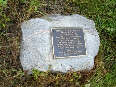
Forcibly removed from northen Indiana to eastern Kansas, over 800 Potawatomi encamped here, cared for sick, and were allowed to hunt; 2 children and 1 woman died; 39 deaths occurred along the entire route.
Sponsors: Hanson Engineers, . . . — — Map (db m33284) HM
Indiana to Kansas, September 4 - November 4, 1838 The 1811 Battle of Tippecanoe on this site was decisive, leading to the loss of their homelands and the removal of Indians from Indiana. At Gunpoint, about 850 Potawatomi passed this location . . . — — Map (db m6433) HM
On County Route 1250 N west of County Route N 300 E, on the right when traveling west.
Some 800 Potawatomi were forcibly removed by U.S. and Indiana officials from near Plymouth, Indiana and taken to eastern Kansas in 1838. Enroute 39 recorded deaths occurred. This tragic event became known as the “Trail of Death”. The . . . — — Map (db m32503) HM
On North West Street at North Front Street, on the left when traveling north on North West Street.
Over 800 Potawatomi were forcibly removed from near Plymouth, Indiana by U. S. And Indiana Officials and taken to eastern Kansas in 1838. This historic event was named the “Trail of Death” after the tragic occurrence of 39 recorded . . . — — Map (db m33251) HM
On Dunlap Woods north of East Main Street, on the right when traveling north.
Over 800 Potawatomi encamped at Sidney after their forced removal by U.S. and Indiana officials from near Plymouth, Indiana. They were being marched to eastern Kansas. Two people died at Sidney, including a child. A total of 39 Potawatomi tragically . . . — — Map (db m33248) HM
On County Road W 500 N west of Road N 225 W, on the right when traveling west.
In 1838 some 800 Potawatomi Indians, being forcibly removed from Marshall County to Kansas, camped along this road, the LaGrange-Logansport State Road. On this “trail of death”, scores of Native Americans suffered and died. The mother of Chief . . . — — Map (db m33812) HM
On West Railroad Street west of North Park Street, on the left when traveling west.
We honor the pioneers and the three Native Americans who died here while on the Trail of Death march in 1838 and are buried in this cemetery — — Map (db m33255) HM
The removal of the Potawatomi Indians from northern Indiana to Kansas took place Sept. - Nov. 1838. Nearly 900 Indians were rounded up by soldiers and marched at gun point for 61 days. So many died on the way and were buried by the roadside that . . . — — Map (db m70609) HM
On Old Jacksonville Road (County Route 8) 0.1 miles east of Peters Road (County Route 8), on the right when traveling west.
Potawatomi
Trail of Death
Sept 4 - Nov 4, 1838
Island Grove
Encampment
During a drought, 850 Potawatomi Indians were force-marched more than 600 miles from Indiana to Kansas. 40 died, mostly children.
After a 6 mile march from McCoy's . . . — — Map (db m32538) HM
On Old Jacksonville Road (County Highway 8) at New Salem Church Road, on the left when traveling west on Old Jacksonville Road.
Potawatomi
Trail of Death
Sept 4 - Nov 4, 1838
McCoys Mill
Encampment
During a drought, 850 Potawatomi Indians were force-marched more than 600 miles from Indiana to Kansas. 40 died, mostly children.
After a 17 mile march from the . . . — — Map (db m32537) HM
On U.S. 31 south of County Road W 375 N, on the right when traveling south. Reported permanently removed.
Rev. Benjamin Marie Petit, of the City of Rennes, France, arrived as the Catholic missionary to the Potawatomi Indians in northern Indiana in November 1837. By June 1838, he had learned much of their difficult language and their culture, and had . . . — — Map (db m247859) HM
Rev. Benjamin Marie Petit, of the City of Rennes, France, arrived as the Catholic missionary to the Potawatomi Indians in northern Indiana in November 1837. By June 1838, he had learned much of their difficult language and their culture, and had . . . — — Map (db m70652) HM
On Sept. 29, 1838, 800 Potawatomi Indians marched through Springfield on the forced removal from Indiana to Kansas. Although many had died and they faced severe hardship, they were encouraged by Judge Polke and Chief I-o-weh to exhibit pride, so . . . — — Map (db m34320) HM
On West Ellsworth Street south of Oakwood Avenue, on the left when traveling south.
In 1838 the northern Potawatami tribes and many Indians from other tribes were forcibly relocated to Eastern Kansas.
The first point to encampment in Illinois on the march westward was near the North Fork River in Danville.
This monument . . . — — Map (db m32501) HM
On West 12th (State Road 17) at Hiawatha on West 12th. Reported missing.
Two miles east, on north bank of Twin Lakes, some 800 Potawatomi Indians were collected in August 1838 and forced to begin their long march to new homes in the West. Many perished on the way. — — Map (db m2307) HM
On County Road S 950 W south of County Road W 75 S, on the right when traveling south.
Over 850 Potawatomi Indians camped here on the Wabash River in Tippecanoe County, Indiana, Sept. 13, 1838, on the forced removal from Indiana to Kansas. There were 106 sick so two doctors were called in, Drs. Ritchie & son. Sanford Cox later wrote . . . — — Map (db m33811) HM
On County Road S 900 W north of County Road W 950 S, on the right when traveling north.
On September 15, 1838, about 860 Potawatomi Indians camped near here on the forced removal from Indiana to Kansas. They had to camp by a dirty stream. Two small children who died on the trek from Williamsport were buried at this camp. — — Map (db m32495) HM
On East Independence Road near North 800 East, on the right when traveling east.
In 1838 a band of over 800 Potawatomi Indians were forcibly removed from their homeland in Northern Indiana and marched to Eastern Kansas. Many died along the trail during the two month trek. This mournful caravan traveled this road on September 14, . . . — — Map (db m9307) HM
On Main Street at South 2nd Street, on the right when traveling east on Main Street.
About 850 Potawatomi Indians camped here near Williamsport September 14, 1838. Two deaths occurred in the evening. Three chiefs were transported in a jail wagon because they refused to leave their beloved homeland in Indiana. — — Map (db m32620) HM
Father Benjamin Marie Petit, a missionary to the Potawatomi in northern Indiana, accompanied them on the forced removal in 1838. He ministered to their needs, both spiritual and physical. He baptized the dying children, "whose first step was . . . — — Map (db m70635) HM
On Broadway (Missouri Route 224) at Highland Avenue, on the right when traveling west on Broadway.
On October 26, 1838 about 800 Potawatomi Indians being forcibly removed from Indiana camped on the river bank opposite Lexington. They ferried the Missouri River on October 27 and were marched on to Northeast Kansas.
This monument is in memory . . . — — Map (db m90921) HM
On Main Street north of East 9th Street, on the right when traveling north.
On September 5, 1838, nearly 850 Potawatomi Indians marched single file through Rochester on the forced removal from Indiana to Western Territory (Kansas). Three chiefs were transported in a jail wagon: Menominee, Black Wolf, and Pepinewa. There . . . — — Map (db m35501) HM
On Oct. 23, 1838, about 800 Potawatomi Indians camped near here on the forced removal from Indiana to Kansas. They camped at Thomas' encampment. Having marched 10 miles after ferrying the Grand River. Wet bottom lands and severe cold made the march . . . — — Map (db m198473) HM
On County Route 240 east of County Route 238, on the right when traveling west.
About 800 Potawatomi Indians camped near here on See's Creek on Oct. 22, 1838 on a forced removal from northern Indiana to eastern Kansas. Two or 3 Indians were placed under guard. Health good so no medicine administered to them. Horses grazed in . . . — — Map (db m243900) HM
On West Center Street west of North Market Street, on the left when traveling west.
About 800 Potawatomi Indians camped at Pyatt’s Point during a forced march from Twin-Lakes, Ind. To the reservation on the Osage River, Kansas. One woman, three children were buried during this stop. — — Map (db m33262) HM
On West Towpath Road west of North Meridian Road, on the left when traveling west.
Here at Chief Winamac's old village, about 900 Potawatomi Indians camped on their forced removal from Indiana to Kansas. A child and a man died here during the encampment. They also left behind 24 too sick to continue. — — Map (db m35399) HM
On County Road N 800 W at County Road W 550 N, on the right when traveling south on County Road N 800 W.
On September 11, 1838, about 850 Potawatomi Indians camped at Pleasant Run, having traveled 17 miles that day on the forced removal from Indiana to Kansas. — — Map (db m35400) HM
On East Main Street at Federal Street on East Main Street.
On Oct. 5, 1838, about 800 Potawatomi Indians camped at McKee’s Creek near here on the forced removal from Indiana to Kansas, known as the Trail of Death. They crossed the Illinois River by ferry. Leaving the river they had to seek water, because of . . . — — Map (db m135378) HM
On East South Street west of South Spartan Drive (State Highway 13), on the right when traveling east.
Designates 1838 Potawatomi "Trail of Death" route starting in Indiana, crossing Illinois and Missouri, and ending at present day Osawatomie, Kansas.
In September 1838, over 850 Potawatomi Indian people were rounded up and marched at gunpoint . . . — — Map (db m198476) HM
[Map] Designates 1838 'Trail of Death' route from Indiana to present day Osawatomie, Kans.
In September 1838 over 850 Potawatomi Indian people were rounded up and marched at gunpoint from their Indiana homeland. Many walked the 600-mile . . . — — Map (db m70654) HM
On North Park Street at Hannibal Street, on the right when traveling north on North Park Street.
Oct. 6, Day 33 of the forced march from their Indiana homeland, 850 Potawatomi Indians camped nearby after traveling 18 miles that day. As the barren land only allowed one choice for encampment, it was named "Hobson's Choice". Water on route was . . . — — Map (db m181376) HM
On Maine Street west of 7th Street, on the right when traveling west.
From October 8-10, 1838, more than 800 Potawatomi Indians were encamped here in Quincy, Illinois and directly across the Mississippi River in Missouri. They were being forced to march from Southern Michigan and Northern Indiana to Eastern Kansas . . . — — Map (db m150021) HM
On Rock Quarry Road south of Illinois Route 104, on the left when traveling north.
On October 7, 1838 nearly 850 Potawatomi Indians camped near here on Mill Creek on the forced removal from Indiana to Kansas. The diary records that they traveled 12 miles that day A child died. — — Map (db m181377) HM
On County Route 1a east of Dave Stockton Drive, on the right when traveling west.
Approximately 800 fatigued Potawatomi camped in this area on September 28, 1838, on a forced removal from Indiana to Kansas. Two children died during the night. Chief I-O-Weh led his people through the town of Springfield the next day. — — Map (db m156778) HM
On East Peoria Street west of S Pearl St, on the right when traveling east.
This monument commemorates the Bulltown (Paola) encampment, November 3, 1838, of the Potawatomi Indians on their 618 mile forced removal trek from their home in Indiana to Linn County, Kansas. Over 850 Potawatomi were forced to leave Indiana at . . . — — Map (db m300004) HM
On North Mason Street south of U.S. 65, on the right when traveling north.
On Oct. 24, 1838 about 800 Potawatomi Indians camped near Carrollton on forced emigration from Indiana to Kansas. Cold was intense on the prairie. — — Map (db m198474) HM
Near South Polk Street near East Mulberry Street, on the right.
On Oct. 22, 1838, about 800 Potawatomi Indians began ferrying the Grand River as they walked from Indiana to Kansas on the forced removal. By dark all the Indians and many of the wagons were over the river and ferried the rest the next day. — — Map (db m198471) HM
Near East Park Highway (State Highway 78) at South Fisher Road.
In 1838, 823 Potawatomi Indians camped near Blue River on the forced removal from Indiana to Kansas. Capt. Hull's group of 23 Indians, 5 horses and 3 wagons were attached to the body of emigration under Judge Polke. — — Map (db m200330) HM
On North Dodgion Street at East Truman Road, on the right when traveling south on North Dodgion Street.
(front:)
In remembrance of the forced removal of the Potawatomi (Neshdabe) people from their homes in northern Indiana to Miami County, Kansas in 1838
(reverse:)
This historical landmark was made possible by the Eagle . . . — — Map (db m200147) HM
On West 5th Street (State Highway 224) at Walnut Street (State Highway 131) on West 5th Street.
On Saturday October 27th the Potawatomi Indians camped in Wellington at the Little Schuy Creek (Big Sni).
On Sunday October 28, a Potawatomi child died. — — Map (db m200328) HM
On County Route 320 at County Route 361, on the left when traveling west on County Route 320.
On Oct. 11, 1838 the emigration moved from the encampment of the last two days. The march was pleasant and without the occurrence of any difficulties. Potawatomi Indians numbering 850 camped here at Pleasant Spring near Palmyra, Mo. Capt. J. Holman . . . — — Map (db m243899) HM
On U.S. 24 west of County Highway 357, on the right when traveling west.
On Oct. 8-10, 1838, about 800 Potawatomi Indians camped here on the west side of the Mississippi River, after crossing by steam-ferry from Quincy. They were enroute to Kansas, being forcibly removed from Indiana. Three children died Oct. 8. Wagons . . . — — Map (db m181374) HM
On Route FF (County Route FF) at Farm to Market Road 327, on the left when traveling west on Route FF.
On October 13, 1838 about 800 Potawatomi Indians camped at Clinton, Mo (North Fork) on the forced removal from Indiana to Oklahoma. They had traveled 17 miles from See's Creek. Chief Ash-Kum asked that Gen. A. Morgan not leave the emigration . . . — — Map (db m221437) HM
On North Main Street at East Library Street, on the right when traveling north on North Main Street.
On October 17 & 18, 1838 about 850 Pottawatomie Indians camped near Huntsville, on their way from northern Indiana to Kansas; a forced march accompanied by soldiers. Having traveled 13 miles in cold rain, a flooded camp caused them to stay a second . . . — — Map (db m96113) HM
On East Main Cross 0.1 miles west of US 61 and US 24 (U.S. 61/24), on the right when traveling west.
Indiana to Kansas 1838
On Oct. 11, 1838, 850 Potawatomi Indians camped at Pleasant Spring near Palmyra on the forced removal from Northern Indiana to Eastern Kansas. They passed through Palmyra at 10 o'clock October 12. That night they camped . . . — — Map (db m36351) HM
On 12th Road west of South Pear Road (a.k.a. - South Peach Road), on the left when traveling west. Reported missing.
Site of
Pottawatomie Indian Church
at
Chi Chi Pi Ou Ti pe Twin Lakes
First Church in Marshall County
erected 1827 by Father Badin.
First Catholic Priest ordained in U. S.
1838 the Indians were moved westward
and the Chapel was . . . — — Map (db m35326) HM
Potawatomi Tribal members were marched from Indiana in 1838 to be relocated on Indian Territory lands. The march was long and arduous. Many Potawatomi, especially children and the elderly, died of illness along the way. Those who survived the . . . — — Map (db m33946) HM
On South 900 West 0.5 miles north of West 950 South, on the right when traveling north.
Wm. Henry Harrison's army camped one mile southwest of here at the Old Gopher Hill Cemetery Nov. 3, 1811 and Nov. 11, 1811 in route to and from the Battle of Tippecanoe. Several soldiers injured during the battle were buried there. — — Map (db m177430) HM
Sugar Creek Mission
1839 - 1849
Potawatomi Settlement
after a forced march from
Northern Indiana
A Journey Called
"Trail of Death" — — Map (db m70574) HM
The hundreds of hand wrought metal items found at this site indicates that a blacksmith shop existed here in the 1800's.
Among the items found were parts of wagon wheels, cooking utensils, muskets, nails, scissors, grading tools, hammers, . . . — — Map (db m70539) HM
The rock lined pits in this area pre-date the arrival of the Potawatomi Indians. Theories are that they may have been used for seed or food storage. The rocks here are shaped differently than any other in the area and their origin is uncertain. . . . — — Map (db m70575) HM
Some of the Jesuit priests who lived and served here
Fr. Christian Hoecken • Fr. Francis Renaud • Fr. Felix Vanquickenborne • Fr. Peter John Verhaegen • Fr. Peter Desmet • Fr. Fleix [sic] Verreydt • Fr. John Baptist Smedts • Fr. Herman Aelen . . . — — Map (db m70638) HM
This is the Memorial and Historical Park dedicated to St. Philippine Duchesne and the Big Sugar/St. Mary Indian Mission, established 1838 to 1848.
The official Shrine to St. Philippine Duchesne is located in Sacred Heart Catholic Church in . . . — — Map (db m70632) HM
In memory of Chief Menominee and his band of 859 Pottawatomie Indians removed from this Reservation Sept. 4, 1838 by a company of soldiers under command of General John Tipton, authorized by Governor David . . . — — Map (db m36122) HM
On U.S. 31 south of County Road W 375 N, on the right when traveling south.
Built in 1834 by William Polke, first white settler in Fulton County, this is the oldest and first frame house in the county and the first frame house built north of Wabash River. It was called the White House and was a stagecoach inn on the . . . — — Map (db m35327) HM
On Quinsippi Island Road, on the right when traveling east.
From 1818 through 1851 groups of American Indians were forcibly removed from states on the east side of the Mississippi River to territories on the west side. One of these removals was the Potawatomi Trail of Death, conducted by William Polke, . . . — — Map (db m181375) HM
On South Peach Road 0.2 miles south of Menominee Drive, on the left when traveling south.
Archaeological evidence suggests that Chief Menominee's Village was located approximately 2½ miles southeast of here on the northern bank of the Yellow River near Wolf Creek. — — Map (db m240659) HM
On North Old US Highway 31 north of County Road E 350 N, on the right when traveling north.
Extending from Michigan City to the Ohio River at Madison. Begun by the state in 1832 with funds obtained from sale of land granted by the Potawatomi Indians. Opened northern part of state to settlers. — — Map (db m35346) HM
On Main Street south of West 8th Street, on the right when traveling south.
Title: Ga bgojwébnegéjuk
Potawatomi for: Those that were uprooted from their natural place
This mural is to honor the Native Americans who were forced from their lands in this area to reservations located in Kansas. This removal took . . . — — Map (db m240943) HM
On Oselka Road at North Whittaker Street, on the right when traveling east on Oselka Road.
Logo text:
"Pokégnek Bodéwadmik" (Pokagon Band of Potawatomi)
New Buffalo was founded during an era of Indian removal from the region. Historically, the Potawatomi lands included millions of acres in Southern . . . — — Map (db m202624) HM
This lighthouse was erected in 1954 to replace the original lighthouse destroyed by the gale and flood of Jan. 31 - Feb. 1. 1953.
It was designed by W.R.H.Gardner, F.R.I.B.A. and built by Dorman, Long & Co. Ltd.
Wm. C. Redman, . . . — — Map (db m246247) HM
Near North Front Street north of Main Street, on the right when traveling north.
Arrived in Rising Sun in 1815 serving as an Indian Agent, US Marshall for Indiana and a judge. From 1817 to 1843, Pepper succeeded in helping create Ohio County, with Rising Sun as its county seat, by separating it from Dearborn County. — — Map (db m222397) HM
On Old U.S. 31 north of County Road 350N, on the right when traveling north.
William Polke was Fulton County's first white settler, coming
in 1830 to survey the Michigan Road. In 1831 he built a log
cabin trading post on south bank of the Tippecanoe River. He was post master of county's first post office called Chippeway, . . . — — Map (db m231180) HM
On Indiana Route 1 0.4 miles south of Route 28, on the right when traveling south.
Gen. Harrison's troops took Ft. Detroit, 1813. He went into Canada against British. Tecumseh was killed there 1813 at the Battle of the Thames.
Afterward:
In 1813 the War Dept. sent over 5000 regular US Troop Rangers who burnt the . . . — — Map (db m248160) HM
On South Saint Louis Boulevard at East Wayne Street, on the right when traveling south on South Saint Louis Boulevard.
The Potawatomi Nation
The Potawatomi are a tribe of Native Americans with historical settlements that extended through the Great Lakes in the present states of Ohio, Indiana, Michigan, Illinois, and Wisconsin. The Potawatomi are a proud and . . . — — Map (db m213359) HM
On River/Dunes Trail west of State Park Road, on the right when traveling west.
Native Americans The Potawatomi were the last Native Americans to occupy southwest Michigan. The Potawatomi name is a translation of the Ojibwa "Potawatomink" meaning "people of the place of fire." In 1835, the Potawatomi were reported . . . — — Map (db m278814) HM
Near Rightmire Road 0.5 miles east of Stowell Road, on the right when traveling north.
This land was occupied for centuries by people who lived in close harmony with their natural surroundings. The Indians, or Native Americans, who lived here belonged to various nations or tribes. In particular, the Ottawa (Odawa), Potawatomi, . . . — — Map (db m212668) HM
Near Constitution Avenue north of East Lakeshore Drive, on the right when traveling west.
As James Hervey Ball explained in 1884, the native peoples "could not well have declined the inducement to have resorted here for council, pleasure, rest and food."
The French recorded the earliest historic groups in the area surrounding Cedar . . . — — Map (db m305417) HM
Near East Bellefontaine Road west of Peninsula Street, on the right when traveling east.
Native Americans have had a presence in this region for almost 10,000 years. During that span, several different cultures moved through the area.
Ancient People
Earliest artifacts found nearby daie to the Paleo Period (11,000 B.C. to . . . — — Map (db m196562) HM
Thin black lines indicate changes in relevance. Between each pair of lines entries are ordered geographically but all have the same relevance.
* Inflectional forms of words are their plurals, singulars, and possessives as well as gramatical tenses and similar variations.
* A noise word is a word that has been deemed too common to index. “The,” “to,” and “then” are examples of noise words. You will find a full list on the Advanced Searches page, in the Rules and Options link of the Keyword Search.