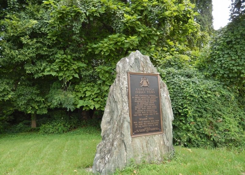
On Safe Harbor Road at Indian Marker Road, on the right when traveling north on Safe Harbor Road.
The Conestoga Indians
in origin largely the survivors
of the defeated ancient
Susquehannas or Minquas
of Iroquoian stock
located their village
variously on these lands
in the Penn Proprietary
Manor of Conestoga
chiefly . . . — — Map (db m161269) HM
On London Vale Road north of Lincoln Highway (U.S. 30), on the left when traveling north.
On September 10, 1710, a patent for 2000 acres of land surrounding this spot was granted by William Penn, proprietor of Pennsylvania, to Daniel Fiere and Isaac Lefever. The patentees were from France and were Huguenots. Here they, with their mother, . . . — — Map (db m202663) HM
On River Road (Pennsylvania Route 441) at Charlestown Road, on the right when traveling south on River Road.
Noted indian trader and interpreter
in early Pennsylvania and Maryland
Frenchman from Canada
who resided
at Fort St. Louis
of the Sieur de la Salle
in present Illinois, 1684-1690
A leader thence of the Shawnee Indians
to Maryland, . . . — — Map (db m161069) HM
On King Street East 0.1 kilometers Sterling Avenue North, on the left when traveling east.
Born in Lancaster County, Pennsylvania, Eby came to Upper Canada in 1806 and purchased extensive lands in this vicinity on which he settled the following year. He was ordained a minister of the Mennonite Church in 1809 and in 1812 was made a bishop. . . . — — Map (db m244322) HM
On Robert Fulton Highway (U.S. 222) 0.1 miles north of Little Britain Road, on the right when traveling north.
This marker perpetuates
the memories of four illustrious
Americans who were identified
with this part of Drumore Township.
Erected by
The Historical Commission of Pennsylvania
and the Lancaster County Historical Society.
. . . — — Map (db m173523) HM
On Eshelman Mill Road 0.1 miles north of Long Rifle Road, on the left when traveling north.
Martin Meylin, 1670–1749, gunsmith of Switzerland settled here in the Pequea Valley in 1710 and made in this gun shop the earliest known Pennsylvania or so called Kentucky Rifle.
He was the first of a group of Lancaster County rifle . . . — — Map (db m160399) HM
On N. George Street 0.2 miles south of Cottage Ave., on the right when traveling south.
Founder 1855 as the Lancaster County Normal School, it was named the first Pennsylvania State Normal School, 1859. Fully Commonwealth-owned after 1917, Millersville became a State Teachers College in 1928, and a State College for liberal arts and . . . — — Map (db m5326) HM
From the colonial times through the early 1900s, water-powered mills were a backbone of industry in the United States. The lower Susquehanna Valley was a popular location for the construction of saw mills. Large timber rafts were floated . . . — — Map (db m234378) HM
On Breezyview Drive 0.2 miles west of Chickies Hill Road ( Route 441), on the right when traveling west. Reported damaged.
During the Civil War an industrial complex existed on the floodplain along the Susquehanna River between Marietta and Columbia which included eight anthracite-fired iron furnaces and the canal and railroad facilities which served them. This . . . — — Map (db m205657) HM
Near South Front Street at Mary Street, on the left when traveling south.
The Paxton Boys and the End of the Resident Indians in the Lower Susquehanna Valley – 1763
By 1763 only one Indian settlement remained below Shamokin in Pennsylvania’s lower Susquehanna Valley. A small settlement of twenty Conestoga . . . — — Map (db m121990) HM
On West Chestnut Street (Pennsylvania Route 23) east of North Mulberry Street, on the right when traveling east.
Martin Shreiner
Noted maker of fine clocks and early fire engines, this civic-minded resident established his cemetery in 1836. He later called it "an ornament to the City."
It was the only public burial place in the City of Lancaster that . . . — — Map (db m230831) HM
On Mapleville Rd at Fahrney Church Rd., on the right when traveling north on Mapleville Rd.
Founder of the Fahrney family in Maryland. Born May 8, 1767, in Lancaster County Pennsylvania. Died April 9, 1837. Son of Doctor Jacob Fahrney who was born at Frankfort, Germany, studied medicine, and in the year 1756 came to American and settled in . . . — — Map (db m229241) HM
On Gap-Newport Pike (Pennsylvania Route 41) at Bridge Street ( Route 741), on the right when traveling north on Gap-Newport Pike.
Unique on American Highways, was erected by the people of Gap in 1892.
It was restored in 1953. The clock’s face, long telling time to passing multitudes on the Newport Road, overlooks, at The Gap, William Penn’s entrance into Conestoga, now . . . — — Map (db m157639) HM
On Walnut Street at North Front Street, on the right when traveling west on Walnut Street. Reported permanently removed.
By late June 1863, the Confederate Army had invaded Pennsylvania. After capturing York, the Rebels planned to take the state capital, Harrisburg, and possibly Philadelphia. To get there, they would need to cross the Susquehanna River at . . . — — Map (db m170239) HM
Near South Front Street at Mary Street, on the left when traveling south.
Native peoples lived in the Susquehanna Valley thousands of years before the arrival of John Harris Sr. In the 16th Century, the Susquehannocks, an Iroquoian speaking people, initially inhabited the northern waters of the Susquehanna River. The . . . — — Map (db m121989) HM
On State Highway 72 at Mt. Carmel Road (State Highway 823), on the left when traveling south on State Highway 72.
5.5 miles southeast is the burial ground of Patrick and Martha Caldwell Calhoun, Parents of John C. Calhoun; Deputy Surveyor 1756; First Representative from Up Country to Commons House of Assembly, 1769-1772; Member of First Provincial Congress, . . . — — Map (db m10627) HM
On West Main Street (State Highway 184) north of Brooks Lane, on the left when traveling south.
Surveyed in 1762 by Patrick Calhoun and named for Gov. Thomas Boone, this 20,500-acre township was one of four townships laid out west of Ninety-Six as a buffer between white and Cherokee lands. In 1763 Scots-Irish families began to settle in the . . . — — Map (db m10605) HM
On Bushong Road 0.3 miles south of Valley Road ( Route 372), on the right when traveling south.
The Atglen & Susquehanna Branch was constructed (1903-1906) by the Pennsylvania Railroad (PRR) as the middle segment of its Low Grade Line, an ambitious through-freight route which extended some 140 miles from Morrisville Yard near Trenton, N.J., to . . . — — Map (db m174229) HM
Covered bridges are very popular as historical landmarks, tourist attractions, and romantic links to a by-gone era. There are literally dozens of organizations dedicated to their preservation, education, and promotion. Yet despite their unique . . . — — Map (db m313492) HM
On Hanover Street (Pennsylvania Route 34) at High Street (U.S. 11), on the right when traveling south on Hanover Street.
Formed January 27, 1750 from Lancaster County. Named for Cumberland County in England, it originally extended to Pennsylvania's western limits. Carlisle, county seat, was founded 1751. Crossed by major roads, county had a key role in westward . . . — — Map (db m15856) HM
On South Front Street at Market Street, on the left when traveling south on South Front Street.
Formed March 4, 1785 from part of Lancaster County. The name honors the eldest son of the French King Louis XVI. Harrisburg, the county seat, was laid out in 1785 and chartered a city in 1860. Since 1812 it has been the State capital of . . . — — Map (db m6399) HM
On Chestnut Street (Pennsylvania Route 462) south of North 2nd Street, on the right when traveling south.
Columbia's strategic position would have made it a fine prize for an invading Southern army bent on disrupting vital communications and supply lines in the North. Railroads connected Columbia with Philadelphia, York, and Harrisburg, and canal . . . — — Map (db m167923) HM
Near Fruitville Pike south of U.S. 30, on the left when traveling south.
David M. Mayer (1836-1891) began construction of his original home in 1867. In 1870, David purchased the 203 acres where the house sits from his father, Martin Mayer. He married Katherine F. Hunsucker in 1868 and had two children. David dies in . . . — — Map (db m136612) HM
On West Market Street (Pennsylvania Route 74/462) at North Pershing Avenue, on the left when traveling east on West Market Street.
Formed August 19, 1749 from Lancaster County, it was Pennsylvania's fifth to be established. York, the county seat, was laid out in 1741. Continental Congress met in York, 1777-78. Here it adopted Articles of Confederation; ratified treaties with . . . — — Map (db m4576) HM
On Broad Street 0.1 miles King Street, on the left when traveling east.
Notable for its fine Georgian
paneling, this was home and
office to Dr. David Ramsay,
the distinguished patriot,
Revolutionary Historian and
physician. Dr. Ramsay
introduced the Small Pox
vaccine to Charleston
and helped found the . . . — — Map (db m27447) HM
On East Andrew Johnson Highway at Old Heritage Road, on the right when traveling east on East Andrew Johnson Highway. Reported missing.
This was built 1792 for George Gillespie by Seth Smith a Quaker stone mason from Lancaster County, Pennsylvania. An early fort originally stood on the site, and was the dividing line between Washington and Greene Counties in 1783. This house was . . . — — Map (db m158190) HM
1827 -- Land is surveyed between
Philadelphia and Columbia,
Lancaster County for a new
transportation system to open
the state's interior to settlement
and commerce. The goal is to link
Philadelphia to Pittsburgh and
compete with New York's . . . — — Map (db m177595) HM
On Orange Street at Duke Street, on the right when traveling west on Orange Street.
"Whether we live or die, we are the Lord's possession." (Romans 14:8)
The quest for a holy life and a holy death has always been part of the human story and a core purpose of this faith community. We are inspired by the great lives . . . — — Map (db m219589) HM
Near New Market Road (Maryland Route 6) 0.1 miles west of Three Notch Road ( Route 5), on the right when traveling west.
The Amish community in St. Mary’s is the largest of three Amish settlements in Maryland. The community is located primarily along MD Routes 6 and 236 in New Market, Charlotte Hall and neighboring Charles County. The Amish moved to the area in 1940 . . . — — Map (db m135330) HM
On Route 236 at Carey Road, on the right when traveling south on Route 236.
The original Liberty Tree was a stately elm in Boston, Massachusetts. It was a rallying point for the Sons of Liberty, an organization of Patriots who played a key role in resisting British tyranny and creating support for rebellion against Great . . . — — Map (db m306867) HM
Conestoga Wagon
The Conestoga wagon is a heavy, covered wagon that
was used extensively during the late eighteenth century.
It was often large enough to transport loads of freight up
to 6 tons and was drawn by horses, mules . . . — — Map (db m226897) HM
Lancaster's leading soldier During Revolutionary War
Friend and Companion-in-Arms
of Gen. George Washington
Member of Continental Congress
Chief Burgess of Lancaster
Warden and Vestryman
of St. James Church
Rock Ford his Lancaster . . . — — Map (db m5211) HM
On E. Main Street (Pennsylvania Route 772) at Elm Street on E. Main Street.
First tobacconist
in Rome (Lititz) Pennsylvania
relocated to this site in 1868
Preserved in 2010
for the people in Lancaster County,
the Commonwealth of Pennsylvania
and the United States of America — — Map (db m276090) HM
Near North Broad Street (Route 501) south of West Kleine Lane, on the right when traveling south.
Count Nicholas Ludwig von Zinzendorf
In 1742, Count Nicholas Ludwig von Zinzendorf of Saxony, the leader and organizer of the modern day Moravian Church, preached at the tavern of Jacob Huber, north of Lititz, while . . . — — Map (db m307921) HM
On Walnut Street (County Road 3006) near South 7th Street, on the right when traveling west.
The southwest corner of 7th & Walnut Streets was a quiet residential enclave at the time of this 1823 sketch. As Philadelphia's rapidly expanding commercial core shifted westward, the homes closest to the 7th Street were demolished in 1868 for . . . — — Map (db m220496) HM
Near North Columbus Street just south of Cameron Street, on the right when traveling north.
Lieut. Col U.S.A., Revolutionary War
1st Battalion, Lancaster County
Pennsylvania Associators, 1777
Assistant Deputy Quartermaster General
Member of
The Pennsylvania Constitutional Convention, July, 1776
Original stone removed . . . — — Map (db m195645) HM WM
On Cascade Drive (County Route T-623) at Virginia Avenue (U.S. 460), on the right when traveling south on Cascade Drive.
To the sacred memory of
John-Jacob and Elizabeth (Helm) Snidow and their children: Barbara, Philip, Christian, Jacob, John, Theophilus and
two daughters.
John-Jacob, of Lancaster County, Pennsylvania, visited this vicinity ca. 1766. He went . . . — — Map (db m162890) HM
On King Street East at Waterloo Street North, on the left when traveling east on King Street East.
Born in Lancaster County, Pennsylvania. John Erb (1764-1832) was a Mennonite of Swiss ancestry. He came to Upper Canada in 1805, acquired 7,500 acres of land from the German Land Company, and settled on the site of Preston. The following year he . . . — — Map (db m259412) HM
Near North 5th Street at Chickies Hill Road, on the right when traveling north.
Opened at a time when blacks and whites legally could not be buried next to one another, this cemetery is the final resting place for generations of African-American wives, mothers, daughters, husbands, and sons—including valiant soldiers. In 1863 . . . — — Map (db m215521) HM
On North Queen Street (Pennsylvania Route 72) at East King Street (Route 462), on the left when traveling north on North Queen Street.
Since its establishment in 1730, Lancaster City has been a bustling, vibrant community with a rich history. Founded by James Hamilton, an English businessman, the city was designed to be the county seat, with a Courthouse placed in the center of . . . — — Map (db m5201) HM
On Furnace Road (Pennsylvania Route 425) 0.1 miles north of Goram Road, on the right when traveling north.
Site of York Furnace Bridge, last of the wooden bridges to be erected across the Susquehanna between Harrisburg and tidewater. The bridge was built by Black & Huber in 1856. During construction four spans of the section between Bair Island and the . . . — — Map (db m173456) HM
On Lincoln Highway (State Highway 462), on the right when traveling west.
(North Side):Dedicated in honor of the Sons and Daughters of Lancaster and York Counties, Pennsylvania who have served in the wars of their country (South Side):Columbia-Wrightsville Bridge Built by Lancaster-York Intercounty Bridge . . . — — Map (db m234375) HM
Near East Niagara Street 0.1 miles west of Fillmore Avenue.
In December of 1828, Benjamin and Mary Hershe Long arrived here from Lancaster County, Pennsylvania, in a covered wagon drawn by oxen. With them were their five daughters, ranging in age from 6 months to 16 years.
Their home, built the following . . . — — Map (db m77330) HM
On Linden Street south of North 5th Street, on the right when traveling south.
(side 1)
Prelude to Gettysburg
One of the great debates of our Country's history and legacy is what scholars call "the two Civil Wars": the first a matter of campaigns, generals, and troop movements and the second focusing on the . . . — — Map (db m122592) HM
On Lancaster County Northwest River Trail, on the left when traveling north.
Peter Grubb was a Pennsylvania iron industry pioneer who founded the Grubb Family Iron Dynasty when he discovered Cornwall Iron Banks in 1737, still the largest domestic iron ore deposit east of Lake Superior. He founded Cornwall, Pennsylvania . . . — — Map (db m248020) HM
On State Park Road 0.8 miles west of Susquehannock Drive, on the right when traveling west.
Farming has been significant for centuries in this region,
thanks to rich soil and plentiful, clear-running water.
The area's earliest farmers were the Susquehannocks,
Indigenous people who relied on simple techniques to grow
corn, beans, and . . . — — Map (db m286504) HM
On Fairview Road 0.3 miles west of Beaver Valley Pike (U.S. 222), on the left when traveling west.
No other section of the eastern A&S more fully demonstrated the Pennsylvania Railroad's (PRR) commitment to re-shape the landscape for an optimum freight road than its seven miles through Providence Township. The gentle compound curve (on paper) . . . — — Map (db m160853) HM
On Richmond Highway (U.S. 1), on the right when traveling east.
Dr. William Brown, Revolutionary War physician, was born in Scotland and raised in Maryland. After studying medicine at the University of Edinburgh, he established a practice in Alexandria. In 1775 he became surgeon of the 2nd Virginia Regiment. In . . . — — Map (db m269864) HM
On Valley Road just north of Fitness Way when traveling north.
Formerly known as "MudFort," this log structure was built circa 1790. The original two-story building measured 21 x 27 feet, and featured an attic and full stone basement. A later tax assessment describes the house as "large" and cites the presence . . . — — Map (db m168956) HM
On Sickles Avenue, on the right when traveling north.
(Around the Upper step):99th Pennsylvania Infantry 2nd Brigade 1st Division 3rd Corps (Front):Fought on this line in the afternoon of July 2nd Present at Gettysburg 339 officers and men Killed and died of wounds 1 officer and 24 men . . . — — Map (db m15086) HM WM
Near Penns Cave Road (Pennsylvania Route 2012) 0.2 miles south of Brush Valley Road ( Route 192).
The Legend of Penn's Cave, as told by Isaac Steele, an aged Seneca Indian, in 1892. In the early eighteenth century, long before settlements reached west of Sudbury, PA, a young Frenchman from Lancaster County, Malachi Boyer, set out to explore . . . — — Map (db m122700) HM
Near West King Street (Pennsylvania Route 462) east of South Prince Street (U.S. 220), on the right when traveling east.
October 22, 1886 - December 31, 1962
Graduate of the Yeates School, The Hotchkiss School, Yale University
University of Pennsylvania School of Law
President and publisher of Lancaster newspapers
Chairman of the board, Intelligencer Printing . . . — — Map (db m5163) HM
On West Chestnut Street east of North Mulberry Street, on the right when traveling east.
Stevens Grave & Memorial Burial place of a true American hero ---------------- Thaddeus StevensLancaster County’s U.S. Representative was the most powerful congressman during the Civil War and early Reconstruction. He was a master . . . — — Map (db m177436) HM
On Orange Street at Duke Street, on the right when traveling west on Orange Street.
Welcome to Saint James and its historic campus. We have ministered to this city for nearly 300 years. The brick church you see today before you has been a place of worship, community, inspiration and reconciliation since 1820.
[Left image of . . . — — Map (db m219581) HM
On West James Street just east of North Mulberry Street, on the right when traveling east.
The 80-mile Philadelphia & Columbia Railroad was the first state-financed and constructed rail line in the U.S. (1823-1834); Pennsylvania Railroad precursor. Original cost estimate: $5,000 per mile in 1823. On completion, actual cost: $34,500 per . . . — — Map (db m177348) HM
On Golf Road 0.2 miles north of General Hand Lane, on the left when traveling north.
Native Americans flourished in the Lancaster County area for thousands of years, long before any European set foot in North America. Though these vast and ancient civilizations have faded from the eye of history, we can still learn much of how . . . — — Map (db m287151) HM
Near Gap Road (Pennsylvania Route 741) east of Bishop Road, on the right when traveling east. Reported missing.
The Little Giant: The Pittsburgh and Lake Erie Railroad, established in 1875, connected the steel centers of Conellsville, Pittsburgh, and Youngstown, Ohio. Only 120 miles long, the P&LE served most of the major industries in the region, . . . — — Map (db m19960) HM
On Coulter Road 0.2 miles north of Biddle Road, on the left when traveling north.
Andreas Gerberich arrived at port of Philadelphia from the parish of Michelreith, Lower Franconia, Bavaria, October 1, 1754. Settling near his brothers in Tulpehocken Township, Berks County, Pennsylvania, Andreas married Barbara Babb in 1758. . . . — — Map (db m262032) HM
On Glen Rock Road (State Road 616), on the right when traveling south.
Sure Fire "The Yankee 3-inch rifle was a dead shot at any distance under a mile. They could hit the end of a flour barrel more often than miss, unless the gunner got rattled." - A member of Lumsden's Confederate Battery, 1864 The . . . — — Map (db m29603) HM
Near Little Antietam Road (Maryland Route 62) 0.6 miles south of Leitersburg Pike ( Route 60), on the left when traveling south.
Good-Hartle Farm
has been placed on the
National Register
of Historic Places
by the United States
Department of the Interior
c. 1765
— — Map (db m146078) HM
Near River Road at Ashbourne Drive, on the left when traveling west.
The First Settlers
The Lenni-Lenape, or "original people", were the first to inhabit the banks of Ganshowahanna, or "falling waters", their name for the Schuylkill River. The Lenni-Lenapes in this area were members of the peaceful tribes . . . — — Map (db m161131) HM
On Champ Boulevard 0.5 miles Spooky Nook Road, on the left when traveling east.
To all individuals who guard the institutions of democracy and help protect the people of Lancaster County in times of danger. Firefighters, Law Enforcement Officers, Emergency Medical Technicians, Paramedics and a host of others. Bravely . . . — — Map (db m228898) HM
On North Belmont Road 0.1 miles north of Queen Road, on the right when traveling north.
Prior to the construction of the Pennsylvania Railroad only Henry Leaman's small farmhouse stood near here. In 1835, Mr. Leaman built a hotel and soon after a railroad station was established. A small village gradually sprung up and by the 1880s . . . — — Map (db m162445) HM
On Mount Hope School Road at Byerland Church Road, on the right when traveling south on Mount Hope School Road.
Built by Charles Christopher and Jacob Beam, Elders. Cir 1755 on Samuel Boyer's land, one third mile west of this site. Used as a meetinghouse until 1848. Moved to this location, November 10, 1949.
The Lancaster Mennonite Conference Historical . . . — — Map (db m213292) HM
On Dorsey Park Trail, on the left when traveling east.
During the late 1800s, engineers started looking to the lower Susquehanna as a source of electric power.
From 1895 to 1931, as demand for electricity increased, four hydroelectric dams were
constructed on the river: at York Haven, Safe Harbor, . . . — — Map (db m173596) HM
On South Main Street at West Arch Street, on the right when traveling south on South Main Street.
[Marker Front]:
Lancaster, founded in 1798, was first called Lancaster Court House and later known as Lancasterville. The seat of Lancaster District from 1800 to 1868, it has been the seat of Lancaster County since then. The town and . . . — — Map (db m286355) HM
On Market Street at South Court Street, on the right when traveling east on Market Street.
Two Dauphin County Courthouses occupied this site at the intersection of Market St. and what was originally known as Raspberry Street, later appropriately renamed Court Street. John Harris, Jr.'s original plan for Harrisburg set aside this land . . . — — Map (db m6652) HM
On Locust Grove Road 0.1 miles north of Locust Grove Road, on the right.
The internationally known scientist and philologist was born one-quarter mile south, in the mansion at Locust Grove. Built 1811 by his grandfather, John B. Haldeman, this was the younger man's home until he moved to Chickies, seven miles south, in . . . — — Map (db m5760) HM
Near River Road 0.5 miles south of Anchor Road, on the right when traveling south.
The Atglen & Susquehanna Branch was constructed (1903-1906) by the Pennsylvania Railroad (PRR) as the middle segment of its Low Grade Line, an ambitious through-freight route which extended some 140 miles from Morrisville Yard near Trenton, New . . . — — Map (db m171780) HM
On Arch Street (Pennsylvania Route 405) north of Race Street, on the right when traveling north.
The first European settlers in this area came primarily from eastern Pennsylvania as well as New Jersey and Delaware. They were mostly English, German, Irish, and Scotch. Among the best known of these early settlers was Marcus Huling, who built a . . . — — Map (db m178306) HM
Near Pine Street east of South 5th Street, on the right when traveling east.
In 1730, the Duffield family immigrated to Lancaster County, Pennsylvania where they purchased farmland Born in 1732, George, named for his father, pursued a religious education, graduated from the College of New Jersey (now Princeton University) . . . — — Map (db m214053) HM
Near Long Level Road (Pennsylvania Route 624), on the left when traveling north.
Mason-Dixon Trail
A portion of the Native Lands Heritage Trail route follows the Mason-Dixon Trail, a 193 mile long hiking path that connects the Appalachian
Trail at Whiskey Spring, PA with the Brandywine Trail at Chadds Ford, PA passing . . . — — Map (db m225122) HM
Near Hallam Street at N 3rd Street, on the left when traveling east.
In the two-story brick building in front of you, newlywed Mary Jane (Rewalt) Magee, the daughter of Wrightsville’s chief burgess, served breakfast to Confederate Gen. John B. Gordon on June 29, 1863. Quite remarkable considering her new husband . . . — — Map (db m199208) HM
On Cherry Street west of North 7th Street, on the right when traveling west.
Directly in front of you stands Hybla, which Jonathan and Susanna Mifflin, a Quaker couple, built about 1800. Mifflin, a Revolutionary War captain (afterward a colonel), and his wife hid freedom seekers on their estate and helped them escape across . . . — — Map (db m173061) HM
On Market Street (Pennsylvania Route 74/462), on the left when traveling east.
Founded in 1749, York County was the fifth county in Pennsylvania and the first to be formed west of the Susquehanna River. Convinced that the area had gained sufficient population, wealth, and the need for a local government, the provincial . . . — — Map (db m100699) HM
On Niagara River Parkway, on the right when traveling north.
Gonder's Flats was named for the Gonder (Gander) family,
who settled in this area in 1799, on land granted by the
Crown. Michael Gonder, a native of Lancaster County
Pennsylvania, emigrated to Upper Canada at the close of
the American . . . — — Map (db m279140) HM
On Queen Street South 0.1 kilometers north of Mill Street, on the right when traveling south.
This house, constructed in 1820 by Joseph Schneider
(1772-1843), is the oldest surviving dwelling in Kitchener.
Built of frame and originally covered with roughcast, it
has been little changed externally since 1850. Schneider,
a native of . . . — — Map (db m244278) HM
On School Street east of Center Avenue, on the right when traveling east.
This house is an original Lisle farmhouse. In its 175 years of history, only two families lived in it.
The Lisle area began being populated by non-native people after the signing of the Treaty of Chicago in 1833. In 1849, Jacob and Mary . . . — — Map (db m304946) HM
Although now part of the Mumma Farm, and known as Mumma Cemetery, this site was first established as a burial ground by the Orndorff family. Living on this farm at the time of his death, Major Christian Orndorff II was buried here in December . . . — — Map (db m89939) HM
On Cumberland Valley Rail-Trail at North Queen Street, on the right when traveling north on Cumberland Valley Rail-Trail.
The expansion of railroads throughout the nineteenth provided new opportunities for economic growth in the Cumberland Valley. Here in Shippensburg, industrial firms chose locations along the tracks in order to receive raw materials and transport . . . — — Map (db m242190) HM
On Colemanville Church Road 0.2 miles west of River Road when traveling west.
Dynamite was essential for expedient construction of the A&S. Rock cliffs on the Susquehanna River were blasted for months to create shelves that carried the rails northward, a lower route for the older Port Road and an upper route for the new . . . — — Map (db m122692) HM
Near River Road 0.5 miles south of Anchor Road, on the right when traveling south.
When construction began in 1903, no other section of the Pennsylvania Railroad's (PRR) A&S Branch likely seemed as improbable as that along the western boundary of Manor Township. There was no existing path sufficient to the purpose of two-track, . . . — — Map (db m160247) HM
On West King Street (Pennsylvania Route 462) at South Prince Street (U.S. 222), on the right when traveling west on West King Street.
Fulton Theatre, directly opposite of this block, is among the nation's oldest continually operating performance halls. When this site was the location of the Lancaster County Jail, a dramatic episode in the Underground Railroad history occurred. The . . . — — Map (db m136439) HM
Near West King Street (Pennsylvania Route 462) east of South Prince Street (U.S. 222), on the right when traveling east.
August 21, 1884 - December 23, 1980
Graduate of the Yeates School, the Hotchkiss School, and Yale University
Publisher and chairman of the board of Lancaster Newspapers, Inc.
Chairman of the board, Intelligencer Printing Company
Co-founder . . . — — Map (db m5162) HM
On South Queen Street (Pennsylvania Route 72) south of West Vine Street, on the left when traveling north.
At the root of Lancaster City's history, one major element is consistent...diversity. In the mid 1700s, the first citizens were from a variety of ethnic and religious backgrounds — German, Scots-Irish, and English.
❖ German . . . — — Map (db m136450) HM
Near Good Drive near Parklawn Court, on the right when traveling north.
In this general vicinity, 300 years past, three Brubaker/Brubacher/Pupather
cousins, Hans (1685-1748) and brothers John Jacob (c. 1687-1751) and John
(c. 1685-1720) were forced from their homeland of Switzerland due to religious
turmoil. After . . . — — Map (db m215235) HM
On Bridge Valley Rd 0.1 miles north of Lake Aldred Terrace, on the left when traveling south.
The last of the wooden bridges to be
erected across the Susquehanna be
tween Harrisburg and tidewater was
located about one-half mile downstream.
It was built by Black & Huber in 1856.
During construction four spans of the
section between Bair . . . — — Map (db m202187) HM
Near Old Valley Pike (U.S. 11) 0.1 miles west of Signal Knob Drive, on the right when traveling west.
Hupp's Hill
Mirroring the story of many Valley settlers, during the mid-1600s a German family surnamed Hupp disembarked in Philadelphia settling first in Pennsylvania's York and Lancaster Counties before migrating south along the Great Wagon . . . — — Map (db m159033) HM
Near North 4th Street at Holston Road, on the right when traveling north.
Johan Casber Rötter on the ship Edinburgh from Rotterdam entered Philadelphia on 13 August 1750. On 12 May 1763 he and Regina Gerhardt, daughter of John Conrad Gerhardt, were married in Bethel Township, Lancaster County, Pennsylvania, by Rev. . . . — — Map (db m306229) HM
On Herring Run Trail 0.5 miles Belair Road, on the right when traveling west. Reported permanently removed.
Home of a Founding U.S. Congressman
William Smith was born in 1728 in Lancaster County, Pennsylvania. He became a successful merchant, and moved to Baltimore in 1761 to expand his shipping business. At the time, revolutionary feelings were . . . — — Map (db m307510) HM
On Harrisburg Avenue west of North Prince Street (U.S. 222), on the left when traveling west. Reported damaged.
On February 23, 1905 Rotary International, the world's first and largest non-profit service organization was founded. Paul Harris met with three of his friends in Chicago, Illinois, to promote business fellowship. The name "Rotary" derived from the . . . — — Map (db m136618) HM
Near Harrisburg Avenue, on the right when traveling east.
Stephen Smith
William Whipper
Entrepreneurs, philanthropists & Underground Railroad agents
This former right of way of the Philadelphia & Columbia Railroad was a critical link in the
national anti-slavery movement that by the 1840's . . . — — Map (db m177607) HM
On Indian Village Road 0.7 miles west of Doe Run Road, on the right when traveling west.
1717
Christian Hershey (1675-1722) comes to what is now Lancaster County with a group of German-Swiss Mennonites.
1736
His grandson, Christian Hershey (1719-1782) purchases 400 acres of land including this farm and builds a small . . . — — Map (db m164775) HM
On East Church Street 0.1 miles east of South Reamstown Road, on the right when traveling east.
OLD REAMSTOWN SCHOOL BUILDING
23 East Church Street
Reamstown, Pennsylvania
On October 12, 1764, John Ferstenower procured the deed.
On March 6, 1865, John Frecht and wife Mary sold lot to Jacob Getz.
On March 6, 1872, Jacob Getz and . . . — — Map (db m234760) HM
On East Main Street (Pennsylvania Route 741) east of Kinder Lane, on the left when traveling east.
This property has been
placed on the
National Register
of Historic Places
by the United States
Department of the Interior
[Center plaque:]
This property recognized by
Historic Preservation Trust
of . . . — — Map (db m136510) HM
On Market Street (County Road 2004) at North 4th Street, on the right when traveling west on Market Street.
The first commercial pretzel bakery was started in 1784 by an entrepreneur from Lancaster County. The tiny operation soon grew into a large factory and set the Philadelphia pretzel industry in motion. Created from the same ingredients that are . . . — — Map (db m213962) HM
107 entries matched your criteria. The first 100 are listed above. The final 7 ⊳
Thin black lines indicate changes in relevance. Between each pair of lines entries are ordered geographically but all have the same relevance.
* Inflectional forms of words are their plurals, singulars, and possessives as well as gramatical tenses and similar variations.