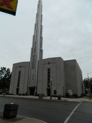
By Bill Pfingsten, June 11, 2012
Augustine Tolton Marker
| On Maine Street at 7th Street on Maine Street. |
| On Maine Street, on the right when traveling east. Reported missing. |
| On Maine Street east of North 4th Street (U.S. 24), on the right when traveling west. |
| On South 30th Street just south of Maine Street, on the right when traveling north. |
| On U.S. 24 at State Route 96, on the right when traveling west on U.S. 24. |
| On Washington Avenue (U.S. 60/62) at Fort Defiance Road, on the right when traveling north on Washington Avenue. |
| On Bunch Road west of Illinois Route 3, on the right when traveling south. |
| On Pecan Street west of Illinois Route 3. |
| On Old U.S. 51 (Illinois Route 37) 1.1 miles south of Redman Road. |
| On Jefferson Street at Shoal Creek Avenue, on the right when traveling west on Jefferson Street. |
| On Highway 24 (U.S. 24) west of County Road 1250 E (County Route 1250), on the left when traveling west. |
| On Main Street (State Highway 89), on the right when traveling south. |
| On East Peru Street (U.S. 6) just west of 8th Street, on the right when traveling west. |
| On West Dakota Street (U.S. 6) just east of North Strong Avenue, on the right when traveling east. |
| On South Spaulding Street at East Caroline Street, on the right when traveling north on South Spaulding Street. |
| On West North Street (Illinois Route 92) at North 2nd Street, on the right when traveling east on West North Street. |
| On Chambers Road (U.S. 52) 0.2 miles south of Willow Road, on the left when traveling north. |
| On U.S. 52 0.1 miles east of 7 Hill Road, on the left when traveling east. |
| On Unnamed campus entrance road 0 miles east of South Clay Street ( Route 78), on the right when traveling east. |
| On Third Street at Madison Street, on the right when traveling north on Third Street. |
| On Unnamed Road in Old Mill Park 0.1 miles east of Chicago Avenue (U.S. 52), on the right when traveling east. |
| On Lincoln Avenue (County Road 12) at Bluff Street, on the left when traveling north on Lincoln Avenue. |
| On West Beardstown Street west of South Pitt Street, on the right when traveling west. |
| On Kennedy Drive west of Water Street, on the right when traveling west. |
| On Illinois 49 0.1 miles south of E 1700th RD, on the right when traveling north. |
| On Darwin Ferry Road at North Union Street, on the left when traveling east on Darwin Ferry Road. |
| On Interstate 70, on the right when traveling west. |
| On National Road (Avery Avenue) (U.S. 40) east of Oak Crest Road, on the right when traveling west. |
| On East Clarksville Road (County Route 2150 N) 0.6 miles east of North 580th Street, on the right when traveling east. |
| On 1900th Street south of Hull Street, on the left when traveling south. |
| On West Lincoln Street (County Route 31) at South Fulton Street, on the right when traveling west on West Lincoln Street. |
| On County Road 1200E 0.1 miles south of U.S. 50, on the right when traveling south. |
| On 1st Street at Fairfax Street, on the right when traveling north on 1st Street. |
| On Jackson Street east of 6th Street, on the left when traveling east. |
| On 7th Street at Jackson Avenue, on the left when traveling north on 7th Street. |
| On E Street 0.1 miles south of West State Street ( Route 316), on the right when traveling south. |
| On Lincoln Highway Road south of County Route 150N, on the right when traveling south. |
| On East Lincoln Highway Road west of County Road 1300E, on the right when traveling west. |
| On County Route 040 N east of Route 1420 E, on the right when traveling east. |
| On South Lincoln Highway, on the right when traveling east. |
| On North 19th Street (U.S. 45) at Western Avenue, on the left when traveling south on North 19th Street. |
| On East County Road 330N east of North County Road 650E (County Route 19), on the right when traveling west. |
| On Shelby Avenue east of North Second Division Street, on the right when traveling east. |
| On North Pike Street north of Route 133, on the right when traveling north. |
| On State Street at State Line Avenue, on the right when traveling west on State Street. |
| On 134th Place at St. Lawrence Avenue, on the right when traveling east on 134th Place. |
| On East 35th Street at South Lake Park Avenue, on the left when traveling east on East 35th Street. |
| On Science Drive at South Lake Shore Drive, on the right when traveling north on Science Drive. |
| On Calumet Ave at 18th Street, on the right on Calumet Ave. |
| On South Wood Street near West Taylor StreetThi when traveling south. |
| On North Willard Court at North Milwaukee Avenue, on the right when traveling north on North Willard Court. |
| Near South Michigan Avenue north of East Ida B. Wells Drive, on the right when traveling south. |
| On South Wabash Avenue north of Balbo Avenue, on the right when traveling north. |
| On West Wacker Drive at North LaSalle Street on West Wacker Drive. |
| On West Monroe Street at South Sangamon Street, on the right when traveling east on West Monroe Street. |
| Near West Jackson Boulevard just east of South Clinton, on the left when traveling east. |
| Near South Harlem Avenue (Illinois Route 43) south of Forest View Terminal Drive. |
| On North River Road, on the right when traveling south. Reported damaged. |
| On Dixie Highway at Hickory Road, on the right when traveling south on Dixie Highway. |
| On Maple Avenue at Presidents Drive, on the right when traveling east on Maple Avenue. |
| On Forest Ave 0.1 miles south of Washington Boulevard, on the right when traveling north. |
| On Longcommon Road at Pine Avenue, on the right when traveling south on Longcommon Road. |
| Near Cottage Grove Avenue 0.2 miles south of 183rd Street. |
| On Scott Avenue at Old Green Bay Road, on the right when traveling north on Scott Avenue. |
| On North 1550th Street north of 1600th Avenue, on the right when traveling north. |
| On South Main Street at East Grand Prairie Street, on the right when traveling north on South Main Street. |
| On South Jackson Street north of East Harrison Street, on the right when traveling north. |
| On South Lincoln Street north of East Lamotte Street, on the left when traveling north. |
| On Illinois Route 33 at North Highway Street, on the right when traveling west on Illinois Route 33. |
| On East Lamotte Street at South Leaverton Street, on the right when traveling east on East Lamotte Street. |
| On South Pike Street north of West Grand Prairie Street, on the left when traveling north. |
| On East Grand Prairie Street at South Lincoln Street, on the left when traveling east on East Grand Prairie Street. |
| On Illinois Route 33 north of Vincennes Ave., on the left when traveling north. |
| On East Main Street (Illinois Route 33) at North 1725th Street, on the right when traveling west on East Main Street. Reported missing. |
| On North Main Street at East Market Street, on the right when traveling north on North Main Street. |
| Near West Lincoln Highway (Illinois Route 38) east of West Locust Street, on the left when traveling east. |
| Near Sycamore Road (Illinois Route 23) 0.1 miles north of Gateway Drive, on the right when traveling north. |
| On Roberts Lane south of Roberts Circle, on the right when traveling south. |
| On Oak Street west of North 4th Street, on the right when traveling west. |
| On North 4th Street north of Lincoln Highway ( Route 38), on the right when traveling north. |
| On Clifford Drive just west of Hickory Street, on the left when traveling west. |
| On Nelson Road north of Lincoln Highway ( Route 38), on the right when traveling north. |
| Near Bethany Road east of Sycamore Street ( Route 23), on the right when traveling east. |
| On Fairview Drive east of Nelson Road, on the right when traveling east. |
| Near Malta Road (County Highway 31) 0.1 miles north of Lincoln Highway (State Route 38), on the left when traveling north. |
| On Railroad Street at North Lafayette Street, on the left when traveling east on Railroad Street. |
| On East Comanche Avenue (Illinois Route 30) at Indian Road, on the right when traveling east on East Comanche Avenue. |
| Near West Prairie Drive east of Peace Road, on the right when traveling east. |
| Near Aberdeen Court 0.1 miles south of Bethany Road, on the right when traveling south. |
| On Edward Street east of South Avenue, on the right when traveling west. |
| On West Army Trail Boulevard at John F. Kennedy Drive on West Army Trail Boulevard. |
| On Geneva Road at Main Street, on the right when traveling east on Geneva Road. |
| On Grace Street near Parkside Avenue, on the left when traveling south. |
| Near S. Brainard Street 0.1 miles south of East Chicago Avenue. Reported permanently removed. |
| Near Brainard Street 0.2 miles south of Chicago Avenue, on the right when traveling west. |
| On College Avenue near Washington Street, on the left when traveling east. |
| On Illinois Route 49 at Palmero Rd (County Road 1425), on the left when traveling south on Illinois Route 49. |
| On Illinois Route 49 at Palermo Road (County Road 1425) on Illinois Route 49. Reported permanently removed. |
| On U.S. 150 0.3 miles north of County Route 2500N, on the right when traveling south. |
447 entries matched your criteria. The first 100 are listed above.
Next 100 ⊳
