
57 entries match your criteria.
Entries Containing All of the Phrases «anne arundel county» AND «maryland»
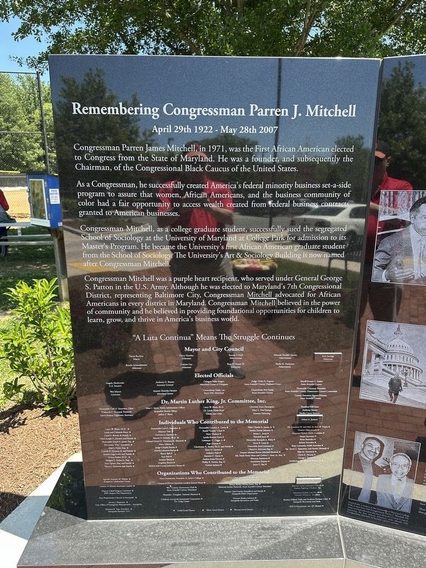
By Pete Skillman, May 29, 2026
Remembering Congressman Parren J. Mitchell Marker
RANKED BY RELEVANCE
1 ► Maryland, Anne Arundel County, Annapolis — Remembering Congressman Parren J. Mitchell — April 29th 1922 - May 28th 2007 —  |
| On Hilltop Lane, on the right when traveling west. | |||
| 2 ► Maryland, Anne Arundel County, Annapolis, Parole — Hockley-in-the-Hole — Patented August 25, 1664 — |
| On Defense Highway (Maryland Route 450). | |||
| 3 ► Maryland, Anne Arundel County, Lothian — Benjamin Welch Owens, CSA — (1836-1917) |
| On Mt. Zion Marlboro Road (Maryland Route 408) 0.1 miles west of Ed Prout Road, on the right when traveling west. Reported damaged. | |||
| 4 ► Maryland, Anne Arundel County, Lothian — Pvt. Benjamin Welch Owens — An Outstanding Example of Courage — |
| On Mt. Zion Marlboro Road (Maryland Route 408) 0.1 miles west of Ed Prout Road, on the right when traveling west. | |||
| 5 ► South Carolina, Richland County, Columbia, Midtown - Downtown — 40-62 — Williams Street / Gist Street — |
| On Gervais Street (U.S. 1) near Williams Street, on the right when traveling east. | |||
| 6 ► Maryland, Anne Arundel County, Annapolis — Who was Henry Davis? — Maryland Lynchings — |
| Near West Street (Maryland Route 450) at Brewer Avenue. | |||
| 7 ► Maryland, Prince George's County, Beltsville — Iron Production: Maryland's Industrial Past / The Iron Making Process |
| Near Old Muirkirk Road. Reported permanently removed. | |||
| 8 ► Maryland, Anne Arundel County, Tracys Landing — The Town of Herrington: Unearthing the Origins of South County — |
| On Old Deale Road. | |||
| 9 ► Maryland, Anne Arundel County, Annapolis — Kunte Kinte-Alex Haley Memorial — |
| On Main Street at Compromise Street, on the left when traveling south on Main Street. | |||
| 10 ► Maryland, Anne Arundel County, Highland Beach — Major Charles and Laura Douglass Town Hall at Highland Beach — |
| On Walnut Drive north of Bay Highlands Drive, on the right when traveling north. | |||
| 11 ► Maryland, Anne Arundel County, Annapolis, Jonas and Anne Catherine Green Park — 7 — Providence - 1649 — The Foundation for a Capital City — |
| On Jonas Green Park Road, on the left when traveling south. | |||
| 12 ► Maryland, Anne Arundel County, Millersville — Shipley’s Choice — |
| On Veterans Highway 0.4 miles south of Benfield Road, on the right when traveling south. | |||
| 13 ► Maryland, Anne Arundel County, Millersville — Shipley's Choice — |
| On Veterans Highway 0.5 miles south of Benfield Road, on the left when traveling south. | |||
| 14 ► Maryland, Calvert County, Solomons — Portion of Hull, Unidentified Bugeye — Round Bottom Log — |
| Near Solomons Island Road South (Maryland Route 2) just south of Thomas Johnson Road, on the left when traveling south. | |||
| 15 ► Maryland, Anne Arundel County, Annapolis, Parole — 6a — The Origin of the Parole Community — Parole Heritage Tour — |
| Near West Street (Maryland Route 450) just west of Chinquapin Round Road, on the right when traveling east. | |||
| 16 ► Maryland, Howard County, Elkridge — Elkridge Landing — Founding and Early Commerce, 1733-1800 — |
| On Furnace Avenue at Riverwatch Avenue, on the right when traveling north on Furnace Avenue. | |||
| 17 ► Maryland, Prince George's County, Beltsville — Iron Production: Maryland's Industrial Past / The Ironmaking Process — |
| On Old Muirkirk Road 0.2 miles north of Muirkirk Road, on the right when traveling north. | |||
| 18 ► Maryland, Anne Arundel County, Annapolis — Southgate Memorial — |
| On College Avenue (Maryland Route 450) at Chruch Circle ( Route 450), on the left when traveling west on College Avenue. | |||
| 19 ► Maryland, Anne Arundel County, Odenton — Tracking Odenton History — The Town the Railroads Built — |
| On Piney Orchard Parkway, on the right when traveling north. | |||
| 20 ► Maryland, Anne Arundel County, Annapolis — Kunte Kinte-Alex Haley Memorial — |
| On Memorial Circle. | |||
| 21 ► Maryland, Anne Arundel County, Edgewater — Establishing a Colonial Town |
| Near Londontown Road 1.3 miles north of Mayo Road (Route 253). Reported permanently removed. | |||
| 22 ► Maryland, Anne Arundel County, Edgewater — Historic London Town and Gardens |
| On Londontown Road 1.3 miles west of Mayo Road (Route 253) when traveling west. Reported permanently removed. | |||
| 23 ► Maryland, Calvert County, St. Leonard — The St. Leonard Polling House — (1926-1974) — |
| On St. Leonard Road (Maryland Route 765) 0.1 miles south of Calvert Beach Road, on the right when traveling south. | |||
| 24 ► Maryland, Anne Arundel County, Edgewater — The Old South River Club — |
| On South River Clubhouse Road 0.8 miles east of Solomon’s Island Road ( Route 2), on the right when traveling east. | |||
| 25 ► Maryland, Howard County, Columbia — Adam the First — |
| On Waterloo Road (Maryland Route 108) at Richard Valley Road, on the right when traveling north on Waterloo Road. | |||
| 26 ► Maryland, Anne Arundel County, Annapolis, Parole — 8 — Political Representation in Ward Three, Parole — African American Aldermen — Parole Heritage Tour |
| Near Hicks Avenue south of West Street ( Route 450), on the right when traveling south. Reported damaged. | |||
| 27 ► Maryland, Anne Arundel County, Galesville — Cedar Park • Tulip Hill — Overlooking West River — |
| On Muddy Creek Road 0.1 miles east of Galesville Road, on the right when traveling east. | |||
| 28 ► Maryland, Anne Arundel County, Galesville — Property-Owning Pioneers — Henry and Catharine "Kitty" Wilson — |
| Near Galesville Road. | |||
| 29 ► Maryland, Anne Arundel County, Glen Burnie — Marley Neck School — |
| On Solley Road 1.6 miles south of Fort Smallwood Road ( Route 173), on the right when traveling south. | |||
| 30 ► Maryland, Anne Arundel County, Severn, South Gate — Queenstown Rosenwald School — National Historic Place — |
| On Queenstown Road 0.1 miles south of Kearneys Lane, on the right when traveling north. | |||
| 31 ► Maryland, Anne Arundel County, Shady Side — Eels, Ducks, and Clams — |
| On East West Shady Side Road west of Bast Avenue when traveling north. | |||
| 32 ► Maryland, Calvert County, Solomons — Majestic Patuxent River — |
| On Solomons Island Road South north of Charles Street, on the right when traveling south. | |||
| 33 ► Maryland, Calvert County, Solomons — Sailing Bateau Witch of the Wave — 16' × 5'11" — V Bottom — |
| Near Solomons Island Road South (Maryland Route 2) south of Thomas Johnson Road, on the left when traveling south. | |||
| 34 ► Maryland, Montgomery County, North Bethesda — Dean Albany — Cal Ripken Collegiate Baseball League Hall of Fame — 2019 Inaugural Class — |
| Near Westlake Drive 0.4 miles north of Westlake Terrace, on the right when traveling south. | |||
| 35 ► Maryland, Anne Arundel County, Fort Meade — Tipton Army Airfield — Fort George G. Meade — United States Army — |
| On O'Brien Road at Simmonds Street, on the right when traveling south on O'Brien Road. | |||
| 36 ► Maryland, Anne Arundel County, Galesville — Maritime Industry on Tenthouse Creek — Blessed by the Bounty of the Chesapeake Bay — |
| On Maryland 255 at Woodfield Road, on the right when traveling west on Maryland 255. | |||
| 37 ► Maryland, Howard County, Columbia — The Little Patuxent River — Patuxent Branch Trail — |
| Near Old Guilford Road 0 miles south of Guilford Road when traveling south. | |||
| 38 ► Maryland, Anne Arundel County, Crownsville — Rising Sun Inn — Historic Generals Highway — |
| On Generals Highway, on the right when traveling south. | |||
| 39 ► Maryland, Anne Arundel County, Linthicum Heights — Benson-Hammond House • Annapolis and Baltimore Short Line / Linthicum Heights • Holly Run Church |
| On N. Camp Meade Rd (Maryland Route 170) 0.1 miles north of Maple Road. Reported missing. | |||
| 40 ► Maryland, Anne Arundel County, Annapolis, Carr's Beach — A History of 'The Beach' — |
| Near Bembe Beach Road north of Edgewood Road, on the right when traveling north. | |||
| 41 ► Maryland, Anne Arundel County, Annapolis, Naval Academy — Evolutions of Strawberry Hill — United States Naval Academy — National Historic Landmark — |
| On Phythian Road. | |||
| 42 ► Maryland, Anne Arundel County, Severna Park — Lynching in America / Lynching in Anne Arundel County — Community Remembrance Project — |
| On West McKinsey Road 0.1 miles east of Baltimore Annapolis Boulevard ( Route 648), on the right when traveling east. | |||
| 43 ► Maryland, Calvert County, Lusby — Calvert Cliffs / Cove Point LNG Platform / Chesapeake Bay — |
| On Lighthouse Boulevard east of Hemlock Drive, on the left when traveling east. | |||
| 44 ► Maryland, Anne Arundel County, Annapolis — George H. Phelps, Jr. — Visionaries of the 1960s — August 5, 1926 — |
| On West Street (Maryland Route 450) at Brewer Avenue, on the right when traveling west on West Street. | |||
| 45 ► Maryland, Anne Arundel County, Annapolis, St. John's College — Dedicated to you, a free citizen in a free land — |
| Near College Avenue. | |||
| 46 ► Maryland, Anne Arundel County, Crownsville — Crownsville Hospital Memorial Park — Crownsville Closes, A New Chapter Begins (1980s-present) — |
| On Crownsville Road, on the right when traveling north. | |||
| 47 ► Maryland, Anne Arundel County, Edgewater — The Ferry at London Town |
| Near Londontown Road 1.3 miles north of Mayo Road (Route 253), on the right when traveling west. Reported permanently removed. | |||
| 48 ► Maryland, Anne Arundel County, Edgewater — William Brown House — London Town Publik House |
| Near Londontown Road 1.3 miles north of Mayo Road (Route 253). Reported permanently removed. | |||
| 49 ► Maryland, Anne Arundel County, Galesville — Let's Play Ball! — Galesville Hot Sox (est. 1915) — |
| On Galesville Road, on the right when traveling west. | |||
| 50 ► Maryland, Anne Arundel County, Pasadena — Beechwood Park — An Historic, Integrated Beach & Amusement Park — |
| Near Beachwood Park Road. | |||
| 51 ► Maryland, Anne Arundel County, Severna Park — Frost's Store and Post Office — B&A Hiker and Biker Trail — |
| Near W. Earleigh Heights Road. | |||
| 52 ► Maryland, Anne Arundel County, Shady Side — Oystering — |
| On East West Shady Side Road west of Bast Avenue, on the right when traveling north. | |||
| 53 ► Maryland, Howard County, Savage — Baldwin Common — |
| On Foundry Street south of Baltimore Street. | |||
| 54 ► Maryland, Anne Arundel County, Annapolis Neck, Thomas Point Park — Thomas Point / Our Abundant Chesapeake — Part of the Bay Heritage / — |
| On Thomas Point Road 1 mile south of Gordon Cove Drive, on the right when traveling south. | |||
| 55 ► Maryland, Anne Arundel County, Arnold — The Dr. Martin Luther King, Jr. Memorial — |
| Near College Parkway. | |||
| 56 ► Maryland, Anne Arundel County, Odenton — At the End of the Road — A Look Back into African American History — |
| On Conway Road, on the left when traveling west. | |||
| 57 ► Maryland, Anne Arundel County, Odenton — Wilsontown — A Look Back into African American History — |
| On Conway Road, on the right when traveling east. | |||
Thin black lines indicate changes in relevance. Between each pair of lines entries are ordered geographically but all have the same relevance.
* Inflectional forms of words are their plurals, singulars, and possessives as well as gramatical tenses and similar variations.
Nov. 19, 2026