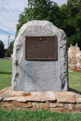
On East Greenville Street (State Highway 81), on the right when traveling south.
i>[Front]
In honor of the
World War veterans of
Anderson County, 1914-1918
Erected by the
American Legion Auxiliary
W.H. Hudgens Unit No. 14
1933
[Reverse]
In honor of the
World War veterans of
Anderson . . . — — Map (db m10673) WM
On Mitchell Road at South Carolina Highway 146, on the left when traveling north on Mitchell Road.
On this site stood the third building erected by Whitefield Baptist Church. The building was used by the Congregation for worship and fellowship until 1957.
Erected as a memorial to God's blessings by his people at this sacred place. — — Map (db m36637) HM
On Holmes Street, on the left when traveling south.
Belton
The Tennis Capital of South Carolina
Tennis Anyone?
Long know as the Tennis Capital of South Carolina, Belton's tennis history can be traced back over 110 years. An 1892 edition of the Anderson Intelligencer . . . — — Map (db m35564) HM
On Myrtle Avenue, on the right when traveling south.
Belton Academy
This site, on a lot donated by Dr. George Brown, was the location of a school for more than a century, Belton Academy, a private school with a classical curriculum, opened ca. 1851 as the town grew up around the new railroad . . . — — Map (db m81782) HM
On North Main Street (U.S. 76) at South Carolina Highway 247, on the right when traveling south on North Main Street.
Replacing the wooden structure located across the street that had served the Belton Community since 1853, the brick Southern & Blue Ridge Combined Railway Depot was designed in 1907 and completed by 1910. In the heyday of passenger and freight train . . . — — Map (db m31012) HM
On Blue Ridge Avenue at Bannister Street on Blue Ridge Avenue.
[Front Center]:
In this place we honor all those who served in the Armed Forces and reflect upon their dedication to duty and country. We recognize the hardships they endured to protect our freedoms and the ultimate sacrifice of life . . . — — Map (db m10757) HM
On River Street (State Highway 247) at William Street on River Street.
This house, built c. 1854 for railroad supervisor Charles C. Chamberlain, was among the first homes constructed in Belton. When the town incorporated in 1855, Chamberlain was chosen as the first intendent. Ira Williams, who was active in . . . — — Map (db m87307) HM
In honor of the
men and women
serving our country
Dorchester Baptist Church
1941-1945
Breazeale, Thomas C
Cox, James B
Cox, William N
Cox, Fred N
Cox, Charles M
Fullbright, Bessie V
Fullbright, Ralph M
Keys, William R . . . — — Map (db m36667) HM
On North Main Street (State Highway 20) at Anderson Street (U.S. 178), on the right when traveling south on North Main Street.
Greenville & Columbia RR
The Greenville & Columbia Railroad, founded in 1845, began construction in 1849. It reached Greenville in 1853, with a branch at this point to Anderson - the Blue Ridge Railroad. The town of Belton grew up around the . . . — — Map (db m35635) HM
On River Street (South Carolina Route 247) at Green Street, on the left when traveling east on River Street.
Est. in 1876, the Belton
Methodist Episcopal Church,
South, was chartered with 44
members, including the
Harris, Smith, McGee, and
Pinson families. Rev. John
Attaway (1835-1903) was its
first pastor while serving
the Sandy Springs . . . — — Map (db m276589) HM
This building served as a classroom and
dormitory for the former Union High School
Dedicated
"To The Glory of God"
July 20, 1991
The Reverend R.H. Mitchell -- Moderator at Renovation
Dr. Earl J. Mathis -- At Dedication
. . . — — Map (db m10752) HM
On McGee Way near Campbell Street, on the left when traveling east.
The National Register
of Historic Places:
The Belton
Standpipe
Dedication Plaque:
The Belton Standpipe
Historical Landmark Built 1908, Restored 1990
Placed on the State and National Archive's Register 1987
Mayor . . . — — Map (db m31166) HM
On Old Greenville Highway (South Carolina Route 88) at Pisgah Road, on the left when traveling west on Old Greenville Highway.
Mt. Pisgah Baptist Church was founded in 1791 as Brush Creek Church with 10 members. In 1809, the church name was changed to Mt. Pisgah Baptist Church. The early church included white and African American members. In 1824, the 2nd church building . . . — — Map (db m238531) HM
On Three and Twenty Road (State Highway 485), on the left when traveling south.
This land, Cherokee territory until 1777, became the final resting place after the American Revolution for early pioneers who settled the area. A number of soldiers of the Revolution are buried here including Robert Pickens, who served in the . . . — — Map (db m9087) HM
On Brushy Creek Road at Colonel Johnson Road, on the right when traveling west on Brushy Creek Road. Reported missing.
[Front]:
This church, founded in 1803, held its first services in the home of John Wilson and was first known as Wilson's Chapel. That year the congregation bought two acres here from George Head; the first church on this site was built . . . — — Map (db m47088) HM
On Honea Path Highway (State Highway 252) at Barkers Creek Road, on the right when traveling south on Honea Path Highway.
Founded in 1821, this is the boyhood church and burial place of Olin D. Johnston. He was decorated for bravery in World War I, served in the S.C. House of Representatives, was twice Governor of S.C., in 1935-1939 and 1943-1945, and U.S. Senator from . . . — — Map (db m9335) HM
On North Shirley Avenue, on the left when traveling east.
Honea Path is the smallest town of the fourteen South Carolina communities with libraries funded by the Andrew Carnegie Foundation. Dr. John Wright, Mayor John Humbert, and Miss Jennie Erwin were leaders in obtaining the $5000 grant. The Honea . . . — — Map (db m10759) HM
Near East Greer Street (U.S. 76), on the right when traveling west.
Rang from 1924 until 1959
August, 1980
Rang for 75th Anniversary
Mr. Ben L. Davis (Uncle Ben, as he was
called) rang the bell until his retirement in
1958. The bell was rung at 9:00 am and
10:00 am and 10:30 am and 11:00 am. . . . — — Map (db m38380) HM
[West Inscription]:
James David Hammett
March 16, 1868
April 16, 1924.
-----
The founder and president
of this company.
-----
"And what doth the lord require
of thee but to do justly, love
mercy and walk humbly with . . . — — Map (db m37530) HM
On Trail Road (South Carolina Route 20) at Clinkscales Road, on the right when traveling south on Trail Road.
(Front)
Once Cherokee hunting grounds, the area was opened in 1784 by settlers obtaining grants for Revolutionary War service. Listed on early maps as Craytons, this crossroad became a thriving community in the early 1800s, featuring a . . . — — Map (db m238535) HM
Near Church Street (U.S. 178) 0.1 miles south of Greer Street (U.S. 76), on the right when traveling south.
[West Facing]:
Came to the colonies and received a land grant from King George III in 1770 in the area known as the 96 District of South Carolina. In 1791 he moved to this locality and accepted a land grant from Charles Pinckney, . . . — — Map (db m40637) HM
On North Shirley Ave west of Chiquola Avenue, on the left when traveling east.
[Front]:
Native American Trade and the "Honey Path"
Town historians long debated the origin of the unusual name "Honea Path." Some attribute it to settler William Honey, who purchased 200 acres northeast of town in 1788. Others say . . . — — Map (db m11252) HM
On West Greer Street (State Highway 252) at South Main Street (U.S. 76), on the left when traveling west on West Greer Street.
In memory of Honea Path veteran
who gave their lives for their country
and in honor of those who served.
War Between the States
[Left Column}: Reuben B. Kay, George Ballentine, James L. Bagwell, Jr., Pleasant Bagwell, John J. . . . — — Map (db m10761) HM
On East Greer Street east of South Main Street, on the right when traveling east.
Depicted in this mural is the first true American - the Eastern Cherokee. The Cherokee
were pushed out of their homeland by settlers of Scotch-Irish descent who arrived by
Conestoga wagons crossing the Allegheny and Blue Ridge mountains.
In . . . — — Map (db m238541) HM
Near East Greer Street, on the right when traveling west.
The talk was the dream of Rev. J.A. Marler, Pastor, to have a church bell. The members were too poor to buy one. Several men began to make plans to purchase a bell by raising money through pledges. Mr. George Lollis, Chairman of Chiquola . . . — — Map (db m38458) HM
These men were killed in Honea Path on September 6, 1934 in the General Textile Strike. This monument is dedicated to their memory, to their families and to all workers.
Claude Cannon, E.M. Knight
Lee Crawford, Maxie Peterson
Ira Davis, C.L. . . . — — Map (db m41259) HM
On East Front Street, on the left when traveling south.
This building and lot donated to the Town of Iva and the Iva District 10 Fire Department by W. Parker Bowie and his wife Marie T. Bowie in honor of his father Luther E. Bowie and his mother Lucia P. Bowie.
Dedicated to the citizens of this . . . — — Map (db m54816) HM
This church, the first Associate Reformed Presbyterian congregation in what is now Anderson County, was organized about 1790 about 1 1/2 mi. SW of this site. Rev. Robert Irwin, its first regular minister, served from 1803 until his death in . . . — — Map (db m11747) HM
On Lowndesville Highway (State Highway 81) south of West Cruette Street, on the left when traveling north.
Oldest Presbyterian Church in continuous existence in Anderson County. Organized in 1789. First pastor, Rev. John Simpson. Congregation worshipped at three sites nears Generostee Creek, three miles west of Iva. Old cemetery at third site. . . . — — Map (db m9479) HM
On Old Lowndesville Highway 0.1 miles Cemetary Road, on the right when traveling south.
This marker designated the third site of this church. Since 1909, the new church, built at
Iva, S.C., has continued to carry on the
faithful witness of our Lord.
Pastors
Rev. John Simpson 1790-1807
Rev. David Humphreys 1821-1869 . . . — — Map (db m19954) HM
On Old Lowndesville Highway 0.1 miles south of Cemetary Road, on the left when traveling south.
This cemetery, dating from the early 19th century, is at the third site of Good Hope Presbyterian Church, founded in 1789. A frame sanctuary was built here in 1856 during the tenure of Rev. David Humphreys (d. 1869), who preached here 1821-1869 . . . — — Map (db m19945) HM
On East Front Street at East Broad Street, on the left when traveling south on East Front Street.
A "Great" Town
In 1886, the Savannah Valley railroad made its way into lower Anderson County. The depot town of Cook's Station was named for Dr. Augustus G. Cook, a local physician and businessman. The town was later called Iva in honor of . . . — — Map (db m43944) HM
On West Front Street (State Highway 81) at East Jackson Street on West Front Street.
[Center]
In memory of those from our community who made the supreme sacrifice in order that w might continue to live in a free and prosperous nation with liberty and justice for all.
[Left Column]
WWI
Robert Latham, Morge . . . — — Map (db m54781) HM
On Elberton Highway (State Highway 184) at Sam Turner Road, on the right when traveling west on Elberton Highway.
[Front]:
At this site once stood the town of Moffettsville, originating with the establishment of Moffett's Mills Post Office on February 16, 1818. By 1883, the town had a population of twenty-five with a physician and general store. . . . — — Map (db m23812) HM
On East Jackson Street at West Front Street ( Highway 81), on the right when traveling north on East Jackson Street.
This beautiful mural of the Old Iva Depot erected in 1886 with the C. & W.C. Train, painted by artist Oscar Velasquez, is dedicated to our forebears, to the churches and citizens of our community for their contribution to the growth of the town . . . — — Map (db m54785) HM
On Amity Road just east of Belton Highway (U.S. 178), on the right when traveling east.
Neals Creek Baptist Church formally
organized in 1803, having previously
been an arm of Big Creek Baptist
Church near Williamston. It was
served by Rev. Moses Holland of Big
Creek Church until Revs. Robert King
and William McGee became . . . — — Map (db m276588) HM
Before Saddlehorn was a neighborhood, it was a rural cattle farm. Corrals like this were used (and still are in some instances) by farmers as holding pens to work with cattle that grazed the surrounding pastures. When farmers built this corral, . . . — — Map (db m11250) HM
On Lebby Street (State Highway 8) just east of Hale Street, on the left when traveling east.
In Memoriam The students of Pelzer Public Schools who gave their lives in World War II Jack Bannister • J. Feaster Beacham • Clinton Dean • Grady Dunlap • John D. McBrearty • Jack Meares • Lamar Neely • John W. Phillips • Harold Ross • . . . — — Map (db m237673) WM
On Lebby Street (State Highway 8) just east of Hale Street, on the left when traveling east.
The first Pelzer Mills School, built in 1881, was a two-story frame building. The school was described as having "the air of a city school" and the mill funded a ten-month term at a time when three-months was common. The school was free and open to . . . — — Map (db m234255) HM
This is the site of a small cemetery used by the Reece family in the 19th century. Because cattle roamed freely in this area for years, the tombstones and other grave markings are broken. In 1977, the readable tombstones were recorded by family . . . — — Map (db m11091) HM
On Easley Highway (South Carolina Route 8) at Midway Road, on the right when traveling south on Easley Highway.
(Front)
Previously housed in a log cabin 1/2 mi. E, White Plains School moved to this site by 1890. At least sixty pupils attended the one-room frame school, which served white families from the White Plains community. The first teacher at . . . — — Map (db m238534) HM
This area was a hub of African-American life from the late-19th to mid-20th centuries. Anderson County Training School, built ca. 1922 as a Rosenwald school, closed in 1954 under the equalization program for black and white schools. It burned in . . . — — Map (db m54824) HM
On Vance Street, on the right when traveling west.
The one-room frame public school organized shortly after the Civil War, housed 76 students and 1 teacher by 1870. The school term lasted 1 month and 10 days. Jane Harris Hunter, founder of the Phillis Wheatley centers for working girls, attended . . . — — Map (db m9647) HM
On Old Greenville Highway (State Highway 88), on the left when traveling north.
This plantation on the old road to Pickensville has been the home of several prominent S.C. families. Many of its owners were members of the Pendleton Farmers Society, and during the nineteenth century, studies, experiments, and advances in . . . — — Map (db m9649) HM
On East Queen Street, on the right when traveling east.
Born Charleston, S.C., 1824.
Graduated West Point 1845.
Brigadier General, C.S.A., 1861.
Commanded 3rd Brigade,
Army of the Shenandoah.
July 21, 1861, at Manassas, Va., where he gave Gen. T.J. Jackson the name "Stonewall." Mortally . . . — — Map (db m39001) HM
[Front]:
Confederate Brig. Gen. Clement H. Stevens (1821-1864) is buried nearby in the Bee family plot. Born in Connecticut, Stevens moved to S.C. after his father's death in 1836. In 1861 he invented the first ironclad battery, which . . . — — Map (db m9680) HM
On Clemson Boulevard (State Highway 76) at State Highway 175, on the right when traveling north on Clemson Boulevard.
In recognition of Dr. Don C. Garrison for his thirty-two years of devoted service as the second president of the College for his dynamic leadership within the College, the State technical college system, and community colleges nationwide; for his . . . — — Map (db m18857) HM
On East Queen Street at Exchange Street, on the left when traveling west on East Queen Street.
Founded in 1790,
Pendleton was established as the judicial seat
for the Pendleton District, today known as
Anderson, Oconee and Pickens Counties.
This Health and Heritage Walking Trail offers
a glimpse into the past and the opportunity . . . — — Map (db m29865) HM
On East Queen Street, on the left when traveling east.
Located in the center of Historic Pendleton (1790), the building now housing the Pendleton District Commission was constructed in 1850 as a general store for Jesse Lewis. The business first came into the Hunter family in 1870 when it became . . . — — Map (db m13903) HM
On Lebanon Road at Autun Road, on the right when traveling north on Lebanon Road.
Directly behind this marker is the homesite of Joe and Mary Broyles Douthit. Born in Anderson County January 30, 1893, graduate of Clemson University, 1914. Farmer and seed breeder, lifelong member and steward of Sandy Springs United Methodist . . . — — Map (db m52075) HM
On April 8, 1790, the Justices of the Peace for Pendleton County purchased this land to establish the courthouse town of Pendleton. Once Cherokee Indian land, the town became the judicial, social and commercial center for what now are Anderson, . . . — — Map (db m9614) HM
On East Queen Street (State Highway 88) at North Broad Streets, on the right when traveling north on East Queen Street.
This London newspaper publisher and defender of a free press emigrated to Charleston in 1783 where he served as state printer and publisher of the first daily newspaper in South Carolina. Later in Pendleton he founded Miller's Weekly . . . — — Map (db m144322) HM
On Cherry Street Extension (State Highway 115), on the right when traveling east.
Born in 1840, Colonel Simpson, lawyer, farmer, and legislator, drafted and executed Thomas Green Clemson's will, establishing Clemson Agricultural College in 1889. Simpson was first president of the college's board of trustees and once owned land . . . — — Map (db m9682) HM
This property was this site of a private residence as early as 1830's. In 1860, John Baylis Earle Sloan and his wife, Mollie Seaborne Sloan, established a home that became known as Tanglewood.
The columns and the ruins seen today are all . . . — — Map (db m16616) HM
These extra wide porches, used for entertaining and enjoyment of he cool breezes, are called piazzas.
Seen on every piazza is a joggling board. In this country, the joggling board got its start in Charleston in 1803. By lightly bouncing, . . . — — Map (db m36306) HM
The paved brick walk leads to the gravesite of Thomas Green Clemson, founder of Clemson University. He was a Scientist, Agriculturist, Statesman, and Educator. His gift to South Carolina of an Institution for the promotion of education in the fields . . . — — Map (db m13938) HM
On East Queen Street, on the right when traveling east.
A native Philadelphian and leading agriculturist, Mr. Clemson was U.S. charge d'affaires to Belgium, U.S. Superintendent of Agriculture, and the 1868 president of Pendleton Farmers Society. He married the daughter of John C. Calhoun, Anna, . . . — — Map (db m9681) HM
On Anderson Highway (State Highway 28 / 76) 0.1 miles south of Excelsior Mill Road.
Dedicated in 1979
in Honor of
Thomas Green Clemson
1807-1888
A Native Philadelphian and
Leading Agriculturist. Mr.
Clemson was U.S. Charge
D'Affaires to Belgium, U.S.
Superintendent of
Agriculture, and the
1868 President . . . — — Map (db m16617) HM
Memories of the Plantation Era -- Owners and Tenants
Owners
Charles Cotesworth Pinckney, elected Lieutenant Governor of South Carolina in 1822, made Woodburn Historic House his summer home around 1830. A graduate of Harvard . . . — — Map (db m15361) HM
On History Lane, on the right when traveling west.
Some 200 yards west of here stands Woodburn, built by S.C. Lieutenant Governor Charles Cotesworth Pinckney by 1832. Dr. John B. Adger, Presbyterian minister to Armenia, bought Woodburn in 1852; in 1881 Augustine T. Smythe began a model stock farm . . . — — Map (db m9588) HM
Sandy Springs Camp Ground: This Methodist camp ground named for the large spring nearby, dates to 1828, when a fifteen-acre site was purchased from Sampson Pope for $45. Early meetings were under a brush arbor until a central wooden shelter . . . — — Map (db m10785) HM
On SC Highway 81, on the right when traveling north.
Dean
Dean is named for the Dean family, whose cemetery is located about a mile west. Samuel Dean came to South Carolina from Maryland in 1786 and settled here in the Mountain Creek area along with the Cummins and James families. Dean and his . . . — — Map (db m11712) HM
Project Data
The Hartwell Project, second in a series of multi-purpose projects planned for the Savannah River Basin, was constructed between October 1955 and December 1963 at a cost of about $90,000,000. The concrete dam rises 204 feet . . . — — Map (db m57899) HM
On Ruhamah Church Road 0.4 miles U.S. 29 and Big Water Road, in the median.
Ruhamah Methodist Church
organized in 1822 and
initially worshipped under
a brush arbor. The first
church, known as the Ruhamah
Meeting House, was built at
this site which congregants
acquired in 1836. Soon after
organizing, members . . . — — Map (db m276580) HM
On Fairplay Road near Rogers Farm Road, on the left when traveling south.
Nazareth on the Beaverdam Presbyterian Church. This is the first known site of Townville Presbyterian Church, founded in this area in 1803 as Nazareth on the Beaverdam Presbyterian Church. The church held its services at members' homes until . . . — — Map (db m10784) HM
On Savannah River Scenic Byway (State Highway 24) 0.1 miles east of Keowee Club Road, on the left when traveling east. Reported missing.
One thousand feet due north on a site now covered by Hartwell Reservoir, the Portman Shoals Power Plant, built by William C. Whitner, began the transmission of high-voltage electricity in 1897 over the longest lines then used for that purpose in . . . — — Map (db m258865) HM
On Savannah River Scenic Byway (State Highway 24), on the right when traveling west. Reported missing.
Named in Honor of
J.H. (Doc) Saylors
For his dedicated public
service to South Carolina
10th Dist. Highway Commissioner
1958-1962
Chairman S.C. Highway Commission
1960-1961 — — Map (db m10845) HM
On West Oak Highway (State Highway 24) at Townville School Road, on the right when traveling east on West Oak Highway.
[Front]
This church, founded as Nazareth on the Beaverdam Presbyterian Church, was established in 1803. It met in members’ homes until they paid $1.50 for a half-acre tract and built a small frame church 2.5 mi. E. The founders’ cemetery . . . — — Map (db m39349) HM
On East Greenville Street at Hamilton Street, on the right when traveling west on East Greenville Street.
One of the oldest congregations and the mother of several others in Anderson County, it was organized in 1788 by Elder Moses Holland who served as pastor for 41 years. Dr. James Bruton Gambrell's mother was a member here. Soldiers of five wars . . . — — Map (db m8441) HM
On West Main Street (State Highway 20), on the left when traveling south.
On May 1, 1865, cadets from the Arsenal Academy at Columbia, under Capt. John Peyre Thomas, who were en route from Greenville to Newberry to be disbanded, met a band of Stoneman's raiders near here in one of the last engagements of the war, which . . . — — Map (db m8395) HM
In Memory of
West Allen Williams
1804 - 1857
Founded Williamston
Donor of Spring
&
Park
-----
He said
This Water Shall by Forever
Free to All People — — Map (db m15795) HM
On West Main Street (State Highway 20) at Minor Street, on the left when traveling west on West Main Street.
"Embraced by the gratitude of an entire community and held in the love and admiration of a descended family, here rests the earthen tabernacles of our beloved founder, West Allen Williams, and family. Reverently moved from a forgotten cemetery a . . . — — Map (db m19714) HM
A South Carolina "Spa"
In 1852, following the discovery of a "healing" spring and the announcement that the railroad was going to be running through the area, the Town of Williamston was chartered. In time, lots were sold for houses to be . . . — — Map (db m15719) HM
On West Main Street (State Highway 20) 0 miles east of Minor Street, on the right when traveling south.
This college was founded Feb. 12, 1872, by the Reverend Samuel Lander, D.D., Methodist minister. On this site stood the college building until 1939. The school was removed to Greenwood, S.C., Sept. 27, 1904, becoming Lander College, in honor of . . . — — Map (db m8440) HM
Near West Main Street (State Highway 20) west of Minor Street.
This site and the one directly in front, Mineral Spring Park, which was donated by West Allen Williams in 1842, formed the nucleus for the new Town of Mineral Springs. In 1852, the town received its charter and the name was changed to Williamston . . . — — Map (db m19733) HM
Near Caesars Head Drive near Geer Highway (Route 276).
The View from the Mountain Bridge Wilderness Area
Located in northwestern South Carolina. The Blue Ridge Escarpment ends with an abrupt drop of some 2,000 feet to the foothills below, where the state's Piedmont region begins. The escarpment . . . — — Map (db m12533) HM
This beautiful falls has been preserved and protected by the Mills and Moore Families for several generations and was acquired in 1981 from James P. Moore and Otis P. Moore for the benefit of the citizens of South Carolina. — — Map (db m20354) HM
The Friends of Bald Rock Heritage Preserve work tirelessly to
remove graffiti and trash while maintaining the natural features
of Bald Rock. They use pressure washers to remove vandalism
and then place organic material called slurry on the . . . — — Map (db m300399) HM
About Caesars Head State Park
Caesars Head State Park is part of an 11,000 acre area known as the Mountain Bridge Wilderness Area. Located in the Blue Ridge Mountains, Caesars Head contains a diversity of plant and animal communities . . . — — Map (db m20699) HM
Beaver (Castor canadensis) inhabited the Conestee area long before the arrival of Europeans in the 18th century. Their numerous dams throughout the Park have inundated much of the former lake bed, creating wetlands which provide habitat . . . — — Map (db m15935) HM
At its largest, Lake Conestee's water surface covered about 130 acres - the area inside the colored boundaries shown on the four aerial photos. This original lake was created when the current dam at the mill was constructed about 1892. As the City . . . — — Map (db m15932) HM
On Main Street, on the right when traveling south.
Was built in 1841 at the request of Alexander
McBee son of Vardry McBee founder of Conestee, S.C.
This building was designed and laidout by
John Adams, Vardry McBee's millwright.
Mr. Adams designed the church in an octagonal shape
so as to . . . — — Map (db m9395) HM
On Main Street 0.2 miles north of Standing Springs Road, on the left when traveling north.
(front)
McBee Chapel
This church is notable for its unusual octagonal form. It was built by John Adams for workers at the nearby McBee’s Factory, a complex owned by Vardry McBee (1775-1864), the industrialist often called “the . . . — — Map (db m198264) HM
On Conestee Road, on the right when traveling south.
1820
The South preferred to send its raw cotton to New England for spinning and weaving when Vardry McBee and his Mill Right John Adams built this Dam at Conestee to power a paper wood and cotton mill.
The mill supplied the news print for the . . . — — Map (db m12166) HM
On Dunklin Bridge Road, on the right when traveling west.
[Front]:
Approximately 2 miles s.e. is the corner of the Old Indian Boundary Line. Nearby is also the original site 1785 of the following:
Lebanon Church, the Rev. Mark Moore's School, the Grove Settlement.
The church . . . — — Map (db m16323) HM
On Dunklin Bridge Road (State Highway S-23-68) west of Lebanon Church Road.
This United Methodist Church was originally located about 1¼ miles east and named the Grove. It was visited by Bishop Francis Asbury in 1790 and 1800. Relocated about ½ mile SW of here after the land was obtained 1832. Present house of worship . . . — — Map (db m9018) HM
On Dunklin Bridge Road (State Highway S-23-68) at Sullivan Grove Way on Dunklin Bridge Road.
The cemetery located about ½ mile north, marks the site of Grove Church, established prior to 1790, one of the first Methodist churches in Greenville County. The present church, renamed Lebanon, is located about 1¼ miles W. of here. A number . . . — — Map (db m9021) HM
On North Main Street (State Highway 14) west of Howard Creek Drive, on the right when traveling west.
[Top Plaque]:
In Honor of our fallen hero
Courtesy of Cannon Memorial Park
[Lower Plaque]:
Although you are gone
your strength to fight for
our lives, property and our
freedom at home will always
be known.
May you . . . — — Map (db m40286) HM
On McCarter Drive (State Highway 418) at Interstate 385, on the right when traveling north on McCarter Drive.
Named in 1985 by action
of the General Assembly
and Highway Commission
in recognition of his
many years of devoted
service to the people
of Greenville County
and of the state
Former Mayor, Fountain Inn
Member
House of . . . — — Map (db m40142) HM
On McCarter Drive (State Highway 418) west of Interstate 385, on the right when traveling west.
[Front]:
In 1766-67 S.C. & N.C. negotiated with the Cherokee to establish a boundary between Indian land to the west and new settlement to the east. This north-south line ran past this point to N.C. and on to Va. In S.C. it ran north . . . — — Map (db m49086) HM
745 entries matched your criteria. Entries 101 through 200 are listed above. ⊲ Previous 100 — Next 100 ⊳