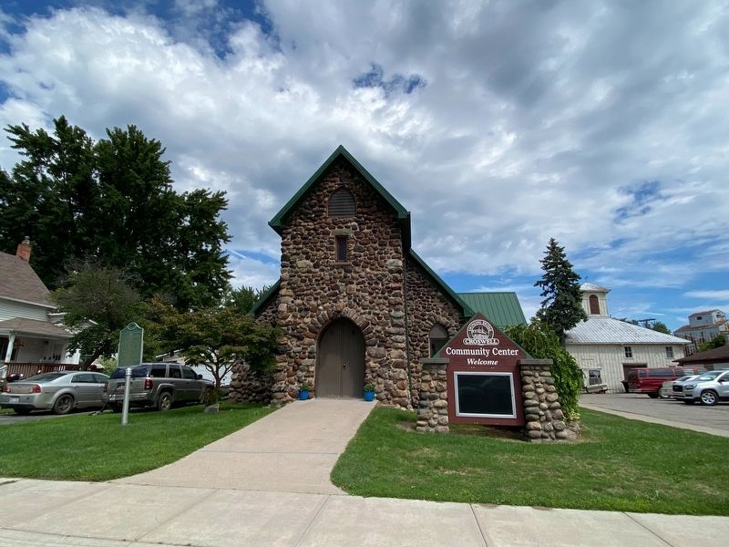
On North Howard Avenue at Maple Street, on the right when traveling north on North Howard Avenue.
This picturesque cobblestone building constructed in 1898 serves as the Croswell chapel of the Trinity Episcopal Church. Its interior features wooden arches and a rood screen between the nave and the chancel. This structure formerly called Christ . . . — — Map (db m88855) HM
On no nearby street. Reported permanently removed.
The tug Sport, one of the nation’s earliest steel-hulled vessels, was built for lumber and steel entrepreneur Eber Brock Ward in 1873 by the Wyandotte Iron Ship Building Works in Wyandotte, Michigan. For forty-seven years the tug towed, . . . — — Map (db m174902) HM
On Huron Avenue (State Highway 90) near Main Street (State Highway 25), on the right when traveling east.
Side 1 Jeremiah Jenks and John L. Woods built the Cadillac House hotel in the Italianate style in 1860. The business opened on July 4 of that year with great fanfare, including songs from the Lexington Glee Club, a parade, dinner and dancing. . . . — — Map (db m204024) HM
On Simons Street near Main Street (Michigan Route 25), on the left when traveling east.
Charles H. Moore & Albert E. Sleeper House
Built 1859
Is listed in the National Register of Historic Places by the United States Department of the Interior
Building #85000064 — — Map (db m212441) HM
On Huron Avenue (Michigan Route 90) near Main Street ( Route 25).
This handsome building was constructed in 1859 by Sanilac
County's first lawyer, John Devine, and served as his law office
until the end of the 19th century. It was then remodeled to
become the library for the village of Lexington and opened . . . — — Map (db m212418) HM
On Main Street 0.1 miles north of Huron Avenue, on the right when traveling north.
The village of Lexington and the local Masonic Lodge combined their efforts and finances to build this three-story Italianate structure in 1876. The village owned the first two floors (the fire department and the opera house); the Masons, the third . . . — — Map (db m41200) HM
He walked our streets as an old captain patrols the deck of his ship-with a weathered affection and an iron sense of responsibility. His compassion and wit were legend. His belief in community inspired us all. No captain ever gave more of himself, . . . — — Map (db m89378)
On State Highway 90 at State Highway 25, on the right when traveling west on State Highway 90.
The first white settlers came to Lexington in 1834 so it was appropriate that the village was the center of the Sesquicentennial Celebration honoring Sanilac County July 4-8th, 1984.
A spectacular parade and fireworks commemorated the Fourth, . . . — — Map (db m88821) HM
On Main Street (State Highway 25) at Hubbard Street, on the right when traveling south on Main Street.
This tall stately Gothic Style church with its elegant wood interior was built in 1874 during Sanilac County's great lumbering era. The Reverend A. B. Flower came to Lexington as a missionary in 1869 and started this congregation known as the Church . . . — — Map (db m41205) HM
On Main Street (Michigan Route 53) at Vail Street, on the right when traveling north on Main Street.
The first twenty-five miles of track for the Port Huron and Northwestern Railroad opened from Port Huron to Croswell in 1879. Marlette citizens lured the railroad by raising $15,000 toward construction of the tracks. The line extended from Saginaw . . . — — Map (db m154436) HM
On Kilgour Street east of South Van Dyke Road ( Route 53), on the right when traveling east.
Methodism in Marlette dates back to 1851 when the first religious sermon in the county was delivered for the Methodist Society. In 1858 the Methodist Episcopalians organized as a church. Their first minister, the Reverend D. W. Hammond, came to . . . — — Map (db m154455) HM
On Main Street (Michigan Route 53) south of Ervin Street, on the right when traveling south.
In 1914 the Marlette Research Club, composed of women in the community, decided to build a public library for Marlette. The club contacted the Carnegie Corporation for a grant to build the library. In compliance with the Carnegie Corporation’s . . . — — Map (db m154435) HM
Near South Ridge Street (State Highway 25) 0.5 miles south of Main Street (State Highway 46).
The Williams was lost in 1863 while carrying a cargo of coal. One of the earliest shipwrecks in the area, she lies in 84 feet of water. The wreck was discovered in 1957 when a commercial fisherman's nets became entangled on an obstruction in the . . . — — Map (db m98913) HM
On South Ridge Street 0.5 miles south of Main Street ( Route 46).
This chink and mortar log cabin
originally stood northwest
of Deckerville in a region of the
county called Burgitville,
or Houndtown, as everyone
in the area owned hound dogs.
Built after the fire of 1881,
it now houses our
Native . . . — — Map (db m212468) HM
On State Highway 25 0.5 miles south of State Highway 46, on the right when traveling south.
This Second Empire style mansion was built in the 1870s by Doctor Joseph Loop. A native of New York, Loop moved to Oakland County, Michigan, in 1843. He and his wife, Jane Gardner Loop pioneered this land in Sanilac County in 1854, and after . . . — — Map (db m88892) HM
On State Highway M at milepost 25 near State Highway 46, on the right when traveling north.
The Sanilac Masonic Lodge was organized in 1868. In 1883 lodge members and township officials agreed to build a combined township and Masonic hall on land donated by Christopher Odfield, a Mason. The foundation was built with three-foot-thick walls . . . — — Map (db m88861) HM
On South Ridge Street (State Highway 25) 0.5 miles south of Main Street (State Highway 46). Reported missing.
The Museum Church was moved here in 2005 from Forestville. Built in the late 1800's, our Museum Church served as a store, a meat market and a tavern before becoming a German Church in 1921. — — Map (db m98919) HM
Near South Ridge Street (State Highway 25) 0.5 miles south of Main Street (State Highway 46). Reported missing.
This turn-of-the-century mercantile features shelves filled with household items that would have been found in a store of this era. The postal unit is from Argyle, Michigan, and was originally established in 1876. — — Map (db m98918) HM
Near South Ridge Street (Michigan Route 25) 0.5 miles south of Main Street.
Dating from the early 1900's, our
general store is half exhibit /
half gift shop. The display
includes vintage merchandise, a
classic cash register, and the
original Argyle, Michigan postal
unit. Old fashioned toys, candy
and books on local . . . — — Map (db m212462) HM
On South Ridge Street 0.5 miles south of Main Street ( Route 46).
This Crib barn, c. 1850, was built before the two
major forest fires in the Thumb of 1871 and 1881.
The Barn was owned (and believed to have been
built) by Charles Decker, who also founded the
Village of Deckerville in the late 1860's.
The . . . — — Map (db m212469) HM
Near South Ridge Street 0.5 miles south of Main Street ( Route 46).
1878 - "Our Little White Church” has a
colorful history. In 1878 it started as a
saloon in Forestville at the corner of
11th St.(Big Gully) and Cedar St.
1920 - It became the home of the
German Evangelical Unity Congregation
of . . . — — Map (db m212466) HM
Near South Lakeshore Road (State Highway 25) 1 mile E. Washington Road.
Sudden tragedy struck the Great Lakes on November 9, 1913, when a storm, whose equal veteran sailors could not recall, left in its wake death and destruction. The grim toll was 235 seamen drowned, ten ships sunk, and more than twenty others driven . . . — — Map (db m154099) HM
Near South Ridge Street 0.5 miles south of Main Street ( Route 46).
This traditional 1920's lakefront cottage features
Greek revival columns,
trap door-type windows
in the gables and an unusual
fireplace made entirley
of beach stone. — — Map (db m212467) HM
On Main Street at Oldfield Lane, on the left when traveling west on Main Street.
The outer breakwaters and harbor basin were constructed in 1951 by
the U. S. Army. Corps of Engineers, with state financial participation.
The public docking facilities were provided through the cooperation of
the Village of Port Sanilac and the . . . — — Map (db m239289) HM
On South Lake Street at Cherry Street, on the right when traveling north on South Lake Street.
• Built in 1886 by the US Lighthouse Establishment
• First lit October 20, 1886 as a fixed-white light
• 4th Order Fresnel lens fueled by kerosene, visible 15 statue miles
• Octagonal brick tower has a focal plane of 52 feet above the ground . . . — — Map (db m259151) HM
On Cedar Street near South Lake Street, on the right when traveling east.
When "Screw Steamers" or "Propellers" first appeared
on the Great Lakes in the 1840's they quickly
became the most efficient form of transportation.
These ships were not only faster than sailing vessels
they also had more compact machinery . . . — — Map (db m239958) HM
On Main Street at Oldfield Lane, on the left when traveling east on Main Street.
This anchor was recovered from the steamer "North Star" by diver John Steele, of Waukegan, Illinois, in
the summer of 1972 and donated to the Port Sanilac Harbor. The "North Star" was a steel propeller
driven package freighter built February 12, . . . — — Map (db m239290) HM
On Sanilac Road (State Highway 19) at Lexington Street, on the right when traveling west on Sanilac Road.
Dedicated to those of Sanilac County who served in World War II Korea Vietnam
and other Presidential declarations involving our Armed Forces — — Map (db m238792) WM
On Sanilac Road (Michigan Route 19) at Lexington Street, on the right when traveling west on Sanilac Road.
To honor the men and women of Sanilac County who answered their country's call in the World War 1914 - 1918
Abend Edward F • Abend Gustav A • Abend Henry E • Abend Louis H • Adair John • Adam Bruce C • Amon Edward G • Amon Floyd R • Amon . . . — — Map (db m257062) WM
On South Sandusky Road (Michigan Route 19) 0.3 miles north of Sylvania Drive, on the right when traveling south.
The Americans Creed
I believe in the United States of America as a government of the people, by the people, for the people; Whose just powers are derived from the consent of the governed; A democracy in a republic; A . . . — — Map (db m257046) WM
On Wheatland Road 0.7 miles north of Argyle Road, on the left when traveling north.
In loving memory of John M. Cole and his wife Susan Seder Cole, pioneer settlers who homesteaded this farm in 1866 and started this cemetery by finding and burying victims of the Forest Fire Sept 5, 1881. He was a Union soldier, serving in . . . — — Map (db m267276) HM
On Bay City Forestville Road (Michigan Route 25) 0.3 miles east of North Bradleyville Road, on the left when traveling east.
Indian Dave was one of the last Chippewas to hunt, fish and trap in the old manner in the Tuscola County area. Dave was born around 1803 and given the name Ish-Don-Quit. According to legend, in 1819 he attended the gathering at the Saginaw River . . . — — Map (db m161021) HM
On North State Street (State Highway 81), on the right when traveling east.
This two-story Italianate commercial building was erected in 1879. One of the first brick buildings on Caro's main street, the structure was built by businessman and philanthropist Charles Montague as a bank and general store. When the building was . . . — — Map (db m101622) HM
On East Sherman Street at North State Street, on the right when traveling south on East Sherman Street.
This captivating piece, painted by artist Kevin Burdick in 2024, honors two pivotal figures in Caro's history-Peter Bush and Ashdonquit-set against the serene backdrop of the Cass River. Their daring journey and unwavering determination played a . . . — — Map (db m307824) HM
On South State Street (State Highway 81) at South Almer Street, on the right when traveling south on South State Street.
On this site at the Hotel Montague, the first meeting of the Caro Rotary Club was held on October 9, 1925. Twenty businessmen gathered for the charter meeting of the Caro Rotary Club.
Rotary is an international organization that spans the . . . — — Map (db m101623) HM
On North Almer Street at West Lincoln Street, on the left when traveling north on North Almer Street.
Twelve persons organized the First Presbyterian Church of Caro in December 1878. The Reverend Edward P. Clark, the Presbyterian minister at Vassar, conducted the organizational meeting with the assistance of the Reverend R.P. Shaw of Bedford, . . . — — Map (db m101632) HM
On South Almer Street, on the left when traveling south.
The beet sugar industry in Michigan began growing rapidly in the late nineteenth century. The declining lumber industry had cleared thousands of acres of land suitable for the cultivation of sugar beets. In 1897 farmers were encouraged further to . . . — — Map (db m101628) HM
On South Almer Street at Joy Street, on the left when traveling south on South Almer Street.
This skillfully designed board and batten Gothic Revival church, first served local Episcopalians in 1880. The congregation had been formed in 1871, the year the town was incorporated. During the 1870s Caro grew to be a major commerce center for the . . . — — Map (db m101616) HM
On North State Sreet (State Highway 81), on the right when traveling east.
The Tuscola County Advertiser began publishing on August 21, 1868. The city's oldest surviving business establishment, it was founded by Henry G. Chapin, a native of Conesus, New York. Chapin edited and published the paper for twelve years. . . . — — Map (db m101614) HM
On North State Street (State Highway 81) at East Sherman Street, on the right when traveling east on North State Street.
Peter DeWitt Bush (1818-1913), the second permanent resident of the village of Caro, donated this site for the county courthouse square in 1866. Then he, along with two other pioneer settlers, moved an old frame church to the site to serve as the . . . — — Map (db m101635) HM
Near South Almer Street at East Congress Street. Reported missing.
On March 11, 1882, thirty-three years after the nation's first state fair was held in Detroit, the Tuscola County Fair was organized as the Caro District Agricultural Association. On September 19-22, 1882, the fair hosted its first agricultural, . . . — — Map (db m160824) HM
On East Sherman Street at North State Street when traveling west on East Sherman Street.
Dedicated to the men and women of Tuscola County who answered their country's call and served in the armed forces of the United States in war and peace. Patriots all. — — Map (db m255035) WM
On North State Street at East Sherman Street, on the right when traveling north on North State Street.
This tree, as a yearling transplant, was grown by the staff at Michigan State University. It was planted in 1955 by the Tuscola County Extension Service to commemorate the 100th anniversary of Michigan State University. — — Map (db m255034) HM
On Main Street at Seager Street, on the right when traveling east on Main Street.
World War I
Auslander, Floyd • Gillies, Russell • Hutchinson, Benoni • Lowe, George • McConnell, Ira • McRae, Donald • Patterson, Lester • Perkins, Ernest • Seeger, Arthur • Spencer, George Leo
World War II
Anker, Dean - MIA • . . . — — Map (db m255047) WM
On Main Street (Michigan Route 81) east of West Street, on the left when traveling east.
This hall was built in 1881 as the center of government activity for Elkland Township. Erected at a cost of $2,600, it was the first brick structure in Cass City. Local timber and brick supplied by the Depews Brick Kilns were used throughout the . . . — — Map (db m160945) HM
On Seeger Street at Church Street when traveling north on Seeger Street.
Three people gathered in June 1877 to form the First Presbyterian Society of Cass City. The congregation soon called its first pastor, the Reverend John Kelland, who led fundraising efforts to build a permanent home for the society. By the fall of . . . — — Map (db m160948) HM
On Schwegler Road at Cass City Road ( Route 81), on the right when traveling north on Schwegler Road.
In honor
of
Horatio S. Earle
First
State Highway Commissioner
of
Michigan
1905 - 1909
Erected at Westerly End
of State Reward Gravel Road
No. 1 - Built 1905 — — Map (db m255048) HM
On Veterans Drive at Church Street, on the right when traveling south on Veterans Drive.
This memorial is placed by Veterans of Foreign Wars Post 3644 and American Legion Post 7, Partner of The United States of America Vietnam War Commemoration to honor the service and sacrifice of Cass City Veterans, their families, and the community . . . — — Map (db m255036) WM
On Cass City Road (Michigan Route 81) at Schwegler Road, on the right when traveling east on Cass City Road.
The state highway system began with the State Reward Road program, created by the Michigan Legislature in 1905. The program provided "rewards" to local governments for road improvements made according to state standards. Horatio "Good Roads" Earle, . . . — — Map (db m160949) HM
On North Bradleyville Road north of West Gilford Road, on the left when traveling north.
In 1887 a camp meeting led by the Reverend David Arnold resulted in the establishment of the Gilford United Brethren in Christ Church. Henry Shannon and John Cragg had invited Arnold to preach to area settlers. In 1889 Charles and Naomi Phipps . . . — — Map (db m163346) HM
Near Richie Road 0.9 miles north of Bay City Forestville Road, on the right when traveling north.
Years ago, the blacksmith was an essential person in the community because they made and fit horseshoes. A blacksmith works with metal, heats it up and bends it to whatever shape is needed. This 24 ft. x 24 ft. building was constructed in 2010 and . . . — — Map (db m181153) HM
Near Richie Road 0.9 miles Bay City Forestville Road, on the right when traveling north.
The Cider Mill was a traditional sight in many Midwestern and Northeastern US farm neighborhoods. Apple trees are quite common in parts of our country partly due to John Chapman (1774-1845), also known as Johnny Appleseed.
Apples have many . . . — — Map (db m181149) HM
On South Street at 4th Street, on the left when traveling west on South Street.
Side 1
Brothers Joseph and James Gage immigrated from Canada in 1860. Joseph filed a homestead claim in Elmwood Township. In 1869, Joseph built a store and mill on his land. Two years later, he platted the village of Gagetown where five . . . — — Map (db m160954) HM
Near Richie Road 0.9 miles north of Bay City Forestville Road, on the right when traveling north.
The garage is one of the original structures on the site. It was built in 1919 while the house was still under construction. This building typifies the ornate detail for which builders John and George Munro were known.
All of the framing . . . — — Map (db m181131) HM
Near Richie Road 1 mile north of Bay City Forestville Road, on the right when traveling north.
Beginning in the mid to late 19th century, farmers were able to produce grain crops that exceeded the needs of their families and industries were creating a demand for the excess crops. The first facilities for receiving and storing grain were flat . . . — — Map (db m181147) HM
Near Richie Road 0.9 miles north of Bay City Forestville Road, on the right when traveling north.
In 1919 James & Cora Purdy hired local builders, John and George Munro, of Gagetown, MI to begin building this Arts and Crafts style home. This home features 15 rooms including three full bathrooms (which was very uncommon in rural Michigan . . . — — Map (db m181128) HM
Near Richie Road 0.9 miles north of Bay City Forestville Road, on the right when traveling north.
The original owner of this farmstead, James L. Purdy, was on a trip to Iowa when he saw an octagonal barn and was determined to have one of his own. When he returned to Gagetown, he hired the Munro Bothers, local builders who had previously built . . . — — Map (db m181133) HM
Near Richie Road 1 mile north of Bay City Forestville Road, on the right when traveling north.
This one room country school was built in 1898 and called the Mast School; named after John and Mary Mast on whose property it was built on Gettel Road in Sebewaing, Michigan. It functioned as a one room country school until Christmas of 1947 . . . — — Map (db m181144) HM
Near Richie Road 0.9 miles north of Bay City Forestville Road.
In 1895, James Purdy started to acquire acreage along the east side of Richie Road. By 1918, he had acquired 560 acres, which was mostly swampland including all of Mud Lake just a half-mile northeast of this Barn Site. His goal was to build a . . . — — Map (db m181139) HM
Near Richie Road 0.8 miles Bay City Forestville Road, on the right when traveling north.
The sawmill building was built in the winter of 2007-2008. It is a 48 ft x 100 ft structure designed to house a Russell & Co. circular sawmill made in Massillon, Ohio, in the early 1900's. It also houses a four head planer made by Witherby Rug & . . . — — Map (db m181169) HM
Near Richie Road 0.9 miles north of Bay City Forestville Road, on the right when traveling north.
The sugar shack was a traditional sight on many Midwestern and Northeast U.S. farms. Here, sap from sugar maple trees tapped nearby was boiled down to make maple syrup, a craft settlers learned from Native Americans in the area. In the early days . . . — — Map (db m181157) HM
On State Road (State Highway 15) 0.1 miles south of Main Street, on the right when traveling south.
Millington Bank Building Built in 1898 Michigan Historical Center, Michigan Department of State Registered Local Site No. 1971
Property of the State of Michigan, 1996 — — Map (db m128200) HM
On Gleason Street at Main Street, on the left when traveling south on Gleason Street.
In 1856 Millington’s first school, a log building, was erected. Between 1866 and 1867 the number of school-age children doubled, and a frame school was built on land obtained from David Lane, owner of the town’s first sawmill. In 1884 Millington . . . — — Map (db m179787) HM
On South Van Buren Road at Sanilac Road (Route 46), on the right when traveling north on South Van Buren Road.
In 1849 Pastor Ferdinand Sievers of Bay County purchased over fifteen hundred acres of virgin forest here in Tuscola County to establish a colony of immigrants from revolution-torn Germany. A year later two families under the leadership of Pastor . . . — — Map (db m101567) HM
On South Van Buren Road at Sanilac Road (Route 46), on the right on South Van Buren Road.
One of four Bavarian settlements in the Saginaw Valley was founded here in June 1850, with the arrival of two families and a pastor. Frankenhilf, which means "Help of the Franconians" remained the community name until it later was changed to . . . — — Map (db m101570) HM
On East Huron Avenue (State Highway 15) at North Water Street, on the left when traveling east on East Huron Avenue.
Here on the Cass River, March 1, 1849, four men led by Townsend North and James M. Edmunds found a suitable place to build a dam and start a town, which was named for Edmunds’ uncle, Matthew Vassar, later the founder of Vassar College, New York. The . . . — — Map (db m163487) HM
On 2nd Street north of West Caro Road ( Route 81), on the right when traveling east.
War of 1812
Al Levi Rogers • A2 Asa Stoddard
Civil War
1 David M. Black • 2 Daniel Butrick • 3 Jeremiah Fox • 4 Lyman Goff • 5 William H. Hamilton • 6 Edward Hardy • 7 Phillip H. Honsinger • 8 Walter Honsinger** • 9 Walter D. Hyde . . . — — Map (db m255031) WM
On West Caro Road (State Highway 81) at Second Street, on the right when traveling west on West Caro Road.
In 1851, Patrick McGlone (1810-1884) settled near here. Later, he built a one-story building that he named "Juniata House" where he provided lodging and food for travelers, as well as "good Barns" stocked "with hay and grain." His family served . . . — — Map (db m101577) HM
On West Caro Road (State Highway 81) at Second Street, on the left when traveling west on West Caro Road.
Aaron Watrous and his crew of loggers came here in 1852 to cut the virgin pine of the Cass River Valley. In 1860 he platted the town, naming it Watrousville, and a few years later constructed this building as a general store. The flagpole in front . . . — — Map (db m101582) HM
On West Caro Road (State Highway 81) at South Ridge Road, on the right when traveling west on West Caro Road.
Circuit riders, who traveled through local villages, served the Watrousville United Methodist Church when it was established in 1856. The congregation became known as the Wastrousville Charge in 1861. In 1865 the first trustees of the congregation . . . — — Map (db m101578) HM
177 entries matched your criteria. Entries 101 through 177 are listed above. ⊲ Previous 100