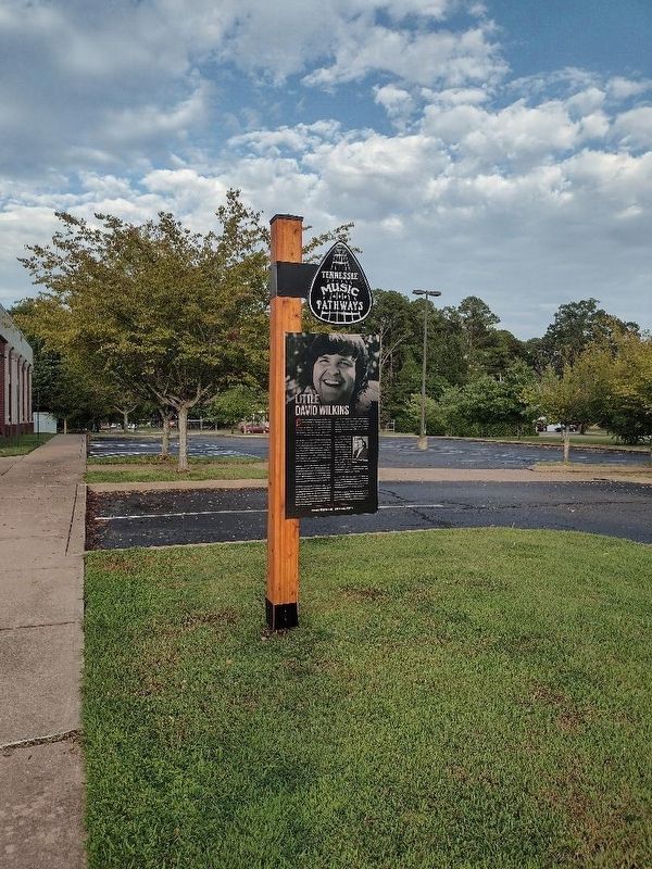
Country singer, songwriter and entertainer Little David Wilkins scored 17 country hits as a performer, mostly in the 1970s, his composition, "Coming on Strong" was a No. 11 pop hit for Brenda Lee in 1966, and he wrote songs for artists as diverse as . . . — — Map (db m261309) HM
The "Pea Vine" A Ghost Railroad. In 1886, Tennessee Midland Railway Company was chartered to build a railroad from Memphis to Virginia. By 1889, 135.6 miles of track were completed to Perryville where it ended for lack of funds. In 1892, . . . — — Map (db m304665) HM
In November 1821 the Tennessee General Assembly passed Acts directing appointed Commissioners to locate an area to be the County Seat of the 1819-confirmed county of Perry. Thus, the legendary community of Midtown was selected to be laid off as a . . . — — Map (db m272357) HM
In November 1821, the Tennessee General Assembly passed acts directing appointed commissioners to locate the county seat of the 1819-confirmed county of Perry. The appointees selected the community of Midtown to be laid off as a town called and . . . — — Map (db m150304) HM
Operated at this location
2 Highway 114 South
Scotts Hill School Parking Lot
Temporary Trailer Classrooms
Scotts Hill Clinic Trailer
Scotts Hill Post Office
Temporary Trailer used as Post Office
until New Post Office was Built . . . — — Map (db m308945) HM
First burial was Daniel H. Murphy, first Murphy to settle in area. At this location was Center School as well as well as the first Methodist Church. It was built by Romulus Sanders Swift in 1843, one of the first Swifts to settle in the area. The . . . — — Map (db m304686) HM
Medal of Honor
Citation
For conspicuous gallantry and intrepidity in action at the risk of his life above and beyond the call of duty. 1st Lt. Gardner's platoon was advancing to relieve a company of the 1st Battalion that had been pinned . . . — — Map (db m221776) WM
Strahl's Brigade / Maj. Gen. John C. Brown's 3rd Div.
/ Maj. Gen. Benjamin E. Cheatham 1st Corps / Gen. John B. Hood's Army of TN. / Confederate States of America — Killed at Battle of Franklin, TN — 30 Nov. 1864 — — Map (db m221798) HM WM
Col. Robert Henry Dyer served during the War of 1812, including the Creek War and as a commander on the left flank under Gen. Andrew Jackson during the Battle of New Orleans on Jan. 8, 1815. The previous night he was injured when his horse fell on . . . — — Map (db m255371) HM
[Front]
Shiloh
To the memory of the faithful
Confederate soldiers of Dyer County
Number of battles fought by them
Confederate
[side] Perryville • Chickamauga • Missionary Ridge • Belmont • Richmond • Peach . . . — — Map (db m221760) WM
[First plaque]
“For our tomorrow they gave their today”
Killed in Action
Bundy Alexander • Robert Edgar Austin • Robert Allen Brewer • Tipton J. Brewer • Robert T. Brown • Clarence P. Butler • Murrow Childress • Earl R. Cooper • . . . — — Map (db m255374) WM
At least fifteen Confederate companies were formed in Dyer County, including Capt. Otho F. Strahl’s Co. K, 4th Tennessee Infantry, and Capt. Tyree H. Bell’s Co. B, 12th Tennessee Infantry. Both men rose to the rank of brigadier general. Strahl was . . . — — Map (db m74634) HM
Korean conflict
1950 - 1953
The forgotten war
In memory of
all Korean War veterans
They told us, “We are going to have peace even if we have to fight for it.” So we fought in the mountains on Heartbreak Ridge and waded ashore at . . . — — Map (db m221780) WM
Dedicated to the memory of those who
made the greatest sacrifice in Vietnam
Charles W.. Stevens • Jimmy R. Orr • James A. Gardner • Robert L. Duncan • Charles E. Novel •
Roy B. Parsons • Joe T. Kemmerling • Ray D. James • Ivy G. Childress . . . — — Map (db m221778) WM
In memory of
all American veterans
This memorial honors all Dyer County veterans who, although separated by generations, shared a common, undeniable goal – to valiantly protect our country's freedoms.
The memories of these Dyer County . . . — — Map (db m221763) WM
To honor the
Confederate compatriots
who sleep eternally in
this hallowed ground
Erected and dedicated
November 30, 2004, the 140th
anniversary of the Battle of
Franklin and death of Brig. Gen.
Otho French Strahl, by the . . . — — Map (db m221785) WM
On November 13, 1924, the world received a smile. For it was on that
day that Emmett Kelly, Jr. was born here in this humble building.
In the years since then, Emmett and his “Weary Willie” character have
entertained and charmed millions of . . . — — Map (db m221803) HM
In commemoration of the first Three Phase Padmount transformer manufactured by the Ermco Three Phase Manufacturing Plant of Dyaraparg, Tennessee.
This transformer, Serial No. 1, was manufactured in December 2000, and placed in service at . . . — — Map (db m224673) HM
Robert M. Tarrant held a courthouse revival in
1840. The first church in Dyer Co., First Methodist,
grew out of this meeting. A frame church, built
1844, deteriorated from disuse during the Civil
War. In 1864 a new structure at Church and . . . — — Map (db m178846) HM
Minglewood was a logging town located west of Dyersburg near the Obion River. Although the town no longer exists, its memory continues through the music of Noah Lewis. Lewis wrote “The
Minglewood Blues,” recorded in 1928 with his band “Gus Cannon . . . — — Map (db m221782) HM
Mrs. Rosa McCauley Parks (1913–2005). She was tired; her feet ached. The year was 1955 in the month of December when this seamstress was returning home on the Cleveland Street bus in Montgomery, Alabama. She was ordered to give up her seat to a . . . — — Map (db m63172) HM
Mrs. Ross McCauley Parks (1913-2005). She was tired: her feet ached. The year was 1955 in the month of December when this seamstress was returning home on the Cleveland Street bus in Montgomery, Alabama. She was ordered to give up her seat to a . . . — — Map (db m221815) HM
Born in Ohio, he came to Dyersburg and practiced law before secession. In 1861 he raised here a company of the 4th Tenn. Infantry for the Confederacy. Winning successive promotion to the grade of brigadier general, he was killed leading his brigade . . . — — Map (db m63174) HM
built 1885,
addition circa 1890.
Has been placed on the
National Register
of Historic Places
by the United States
Department of the Interior — — Map (db m221781) HM
About five miles southeast, in the family cemetery, is buried this veteran of the Revolutionary War. Born in Botetourt Co., Va., in 1763, he later moved to Guilford County, N.C., where he enlisted at the age of 18, serving under Generals Gates, . . . — — Map (db m56290) HM
An important post-Civil War Black educator, Moody
was born to an enslaved man named Daniel and
Jane Freeman, a free woman of mixed race. He
farmed as a free man with his mother in Dyer
County; they hired his enslaved father as labor.
After . . . — — Map (db m255378) HM
Southern Battle Flag St. Andrews Cross emblazons blue Across a blood-red field, Adorned by stars of purest white; Our Southern battle shield. fly, dear flag, o'er heroes brave Both living and departed; Steadfast to the Southern Cause Our . . . — — Map (db m81520) WM
In 1836, this church, sometimes called Palestine, stood in the thriving village of Concordia on the Randolph Road Stage Route about one mile west of Braden. Political speeches were made and voting took place here for Civil District 8. In the 1870s, . . . — — Map (db m148508) HM
The following is the Time-Line of some of the Leading Events to Grand Junction Tennessee becoming The Bird Dog & Field Trial Capital of the World
1870 (About) After the Civil war ended, West Tennessee became a mecca for quail . . . — — Map (db m186917) HM
From here, Col. Benjamin H. Grierson's task force (6th Ill., 7th Ill., 2nd Ind. Cav., Btry "K", 1st Ill. Art.) raided into the deep south. Using as advanced guard Federals in Confederate uniform and other stratagems, he cut the Mobile & Ohio RR at . . . — — Map (db m19303) HM
The "Queen of the Confederacy" was born here January 11, 1832. In 1858 she married Francis Pickens, United States Ambassador to Russia and later Governor of South Carolina. During the Civil War, Lucy was the only woman honored by having her portrait . . . — — Map (db m37274) HM
This Protestant Episcopal Church was first established as a mission in 1832, consecrated in 1843. Rev. Samuel George Litton was its missionary and first rector. It was established by the efforts of Mrs. Mary Hayes Gloster a widow from Warrenton, . . . — — Map (db m62006) HM
Settled in 1819 on the site of an Indian trading post, it was named for General La Fayette's ancestral home in France. He visited La Grange in 1824 and called it the "Beautiful Village." Its location on a bluff made it a natural military post; . . . — — Map (db m62007) HM
Federal forces occupied LaGrange during the war, 1862-1865, and made it an important supply base. Gen. William T. Sherman established his headquarters here when the occupation began in 1862. In April 1863, Union Col. Benjamin H. Grierson left here . . . — — Map (db m51816) HM
This house was the birthplace of Lucy P. Holcombe Pickens (June 11, 1832 - Aug. 8, 1899), a noted beauty of ante-bellum days and the most famous person born in La Grange. Mrs. Pickens is the only woman whose likeness has appeared on American . . . — — Map (db m37276) HM
About a mile south was the burial site in 1854 of Mrs. Mary Hayes Willis Gloster, founder of Immanuel, the first Episcopal church to be consecrated in West TN; her daughter Elizabeth Willis Gloster Anderson in 1873; her son-in-law John Anderson in . . . — — Map (db m19300) HM
This house was built in 1828 by Major Charles Michie, a veteran of the War of 1812. During the War between the States it was for a time headquarters for Maj. Gen. William Tecumseh Sherman of the Federal Army. It was also several times occupied by . . . — — Map (db m19299) HM
Named for Cypress Creek and at other times called Davis for the pioneer Davis family, ancestors of the Emerson family of Somerville, this church stood in the Center Point community on land owned now (1996) by James H. Shelton, great-great-grandson . . . — — Map (db m55399) HM
By late in 1863, the Union army occupying West Tennessee strongly defended the Memphis and Charleston Railroad, which ran eastward from Memphis through Moscow. Federal infantry, including the U.S. Colored Troops of the 2nd West Tennessee . . . — — Map (db m37273) HM
Battle of Moscow December 4, 1863Three thousand Confederate cavalry with artillery, led by Gen. James Chalmers, attacked the Memphis & Charleston Railroad bridge over Wolf River and ambushed Col. Edward Hatch's brigade of Union cavalry crossing . . . — — Map (db m81524) HM
Oakland
Presbyterian Church
has been placed on the
National Register
of Historic Places
by the United States
Department of the Interior
Organized 1888 — — Map (db m179105) HM
Born in Rossville on January 12, 1904, Fred McDowell was one of America's eminent blues artists. His work, rooted in the Delta blues tradition, won him international fame. Of his unique bottleneck guitar style he said: "I make the guitar say what I . . . — — Map (db m19310) HM
(side 1)
On December 27, 1863 Lafayette Station (now known as Rossville) saw the culmination of an incredible month in West Tennessee history. It began with a Presidential order giving General Bedford Forrest an independent command. The . . . — — Map (db m148502) HM
Fayette County was organized the first Monday in December, 1824, in the home of Robert G. Thornton, ten miles S. East on North fork of Wolf River. It was made a part of the district which David Crockett then represented in the state legislature. — — Map (db m33856) HM
A number of black Fayette County sharecroppers who participated in a voter registration drive were evicted from their lands in 1959-60. Many of them moved to "Tent City", also called "Freedom Village", where they lived in military surplus tents . . . — — Map (db m122255) HM
This brick building was built between 1910 and 1915. It originally had a concrete block front, but it was replaced with the current front after a 1950's fire. The north side housed the Hardware & Garage of E.H. Gibson, later operated by his son E.H. . . . — — Map (db m267345) HM
This building is home to the Humboldt Fire
Department and was built in the early
1950's. This two story building is of brick
and block construction. It features two
large bays for fire trucks, emergency
vehicles and equipment. For many . . . — — Map (db m194191) HM
This building was built between 1910 and 1915. It was first occupied by Warren James and used for his grocery store. In 1926, Dan S. Tuttle and Robert Jones opened a dry cleaners here. It continued under Tuttle's ownership for nearly 50 years and . . . — — Map (db m267349) HM
This Neoclassical building was erected in 1912 for Humboldt's City Hall. Originally it housed the Mayor's office and Humboldt Business Men's Club (later Chamber of Commerce) on the first floor with the courtroom on the second floor. The city jail . . . — — Map (db m264336) HM
This two story brick building was constructed
circa 1866 by Col. George W. Day.
This building housed the town's court rooms
in the 1860's and 1870's. It was the home to
one of Humboldt's longtime dry goods
merchants, the Baum Family. The . . . — — Map (db m194188) HM
This building was built in the mid 1880's, featuring beautiful cast iron moldings on the exterior. Originally, it was home to Hamilton & Scales Drug Store, with a grocery store in the east portion. The 2nd floor was once used as a dentist office in . . . — — Map (db m267360) HM
This brick building was built in the mid 1880's and matched the style of the buildings on the east and west side. It had large floor to ceiling windows in the front with tall double doors. It has been a variety of businesses over the years, . . . — — Map (db m267357) HM
This two story brick building was built
between 1891 and 1897. It has been home to
a variety of businesses over the years.
Originally it was the office of the West
Tennessee Leader newspaper and printing
company. Beginning in the early 1900's . . . — — Map (db m194192) HM
This building was built to match the two buildings to the west in the mid 1880's.
It originally housed a dry goods store. In the 1890's it was purchased by Thomas P. Bethshares to house his new dry goods and grocery store. Mr. Bethshares would . . . — — Map (db m267356) HM
This building was built between 1891 and 1897
and has housed a variety of stores in its
history. The exterior has only had minor
changes made over the years such as a new
door and windows. Some of the businesses
that have claimed this as their . . . — — Map (db m194193) HM
This two story brick building was built in two
parts. The east side was built first as a
one-story building in the mid 1880's, with a
second story being added around 1905.
The west side was built as a two story
building around 1890 to house a . . . — — Map (db m194187) HM
This building was built in the mid
1880's. It is one of a set of four one
story brick buildings that were built
along the south side of Main Street
after the 1881 fire. Originally it was the
home of a harness shop.
By 1900 a small printing . . . — — Map (db m194194) HM
This large two-story building was built in the late 1880's by O.C. Sharp to house his Dry Goods store with an Opera House upstairs.
Circa 1910 the front was changed to the yellow bricks you see today. Mr. Sharp remained in the Dry Goods & Clothing . . . — — Map (db m267353) HM
This building was built between 1887
and 1891 with the first floor housing a
grocery store and the upstairs used as
office space. In the early 1900's it would
become a dry goods and clothing store,
then back to a grocery store. Around 1915
the . . . — — Map (db m194186) HM
This two story building was built in the 1920's and replaced the last remaining wood frame structure on Main Street. The small one-story clapboard siding store was used as a barber shop and business office before being razed. The new building has . . . — — Map (db m264333) HM
This building was built in the late 1890's
and was home to McFarland Dry Goods.
It remained as a clothing store through the
1920's. The original store front was
changed sometime before 1930 with a large
triple window being added on the 2nd . . . — — Map (db m194185) HM
This two-story building was built in the mid
1880's and housed only 3 businesses as of
2018. It was built by J.J.R. Adams.
Adams and a brother came to Humboldt after
the Civil War to open a grocery & hardware
store. Adams, along with a . . . — — Map (db m194183) HM
This two story brick building was constructed in the late 1890's by the Marks Brothers from Jackson. They built this building to house their Dry Goods, Clothing, and Millinery Store. Shortly after 1900 the Strasberg Brothers bought the store and . . . — — Map (db m267350) HM
This one story building was built
in the 1890's and housed a printing office.
By 1900, it was divided into three
offices with a barber using the
Main Street entrance.
The other two sections housed a cobbler
and doctor's office with entrances . . . — — Map (db m194201) HM
This two-story building is one of the oldest
structures in downtown Humboldt. It was
built shortly after the Civil War. One of the
first occupants was the grocery firm of
Waddill & Stobaugh. It survived the 1881 fire
that destroyed most of . . . — — Map (db m194182) HM
This one story brick building was built
circa 1900 and originally had a tall
Victorian style covered porch on the front.
It was the home of Hamilton Grocery
Company for many years in the early
1900's. Simmons Shoe Store operated in
this . . . — — Map (db m194203) HM
This building was built circa 1900 and
originally had large glass windows and doors
across the front. A variety of businesses have
operated in this location over the years. In
the early 1900's there was a harness repair
shop, grocery store, . . . — — Map (db m194204) HM
This building was built shortly after the Civil War and was referred to as Shaw's Hall by the 1880's. There have been grocery stores, a meat market, a saloon, restaurants and 5&10 store that have claimed this building as their home. The upstairs has . . . — — Map (db m267344) HM
This beautiful Art Deco building was
built in 1941. “Life Begins for
Andy Hardy” was the opening night
movie on October 16, 1941.
The manager was Wayne Harrington
with Elizabeth Cox and Spicer Taylor as
its first employees. Originally it had . . . — — Map (db m194202) HM
Part of this building dates to the 1890's and began its history as a Tin and Stove Shop. It originally had a dirt floor and was used as a tin shop until about 1913.
A produce shop was in this location in 1915, and it was noted that one wall was . . . — — Map (db m264305) HM
This one-story building was built circa 1900.
It was first used as a laundry and dry
cleaners. In 1905 a bakery was operating at
this location. J.A. McAlister, Sr. operated
his radio repair store - Humboldt Electric
Shop - in this building from . . . — — Map (db m194205) HM
This property
has been placed on the
National Register
of Historic Places
by the United States
Department of the Interior
Bonds House
1923 — — Map (db m194177) HM
This building was built as
the freight depot of the Mobile &
Ohio Railroad company.
Construction began sometime in the
late 1800's. It continued to operate as
a depot and storage facility for several
railroad companies before being sold . . . — — Map (db m194190) HM
(preface)
Gen. Nathan Bedford Forrest led his cavalry brigade on a raid through West Tennessee, Dec. 15, 1862—Jan 3, 1863, destroying railroads and severing Gen. Ulysses S. Grant’s supply line between Columbus, Kentucky, and . . . — — Map (db m156775) HM
This church is an example of Gothic Revival Architecture. The exterior of the sanctuary consists of standing buttresses, towers, a copper spire and cross, and pointed arch stained-glass windows. Transept windows were designed and installed by the . . . — — Map (db m21545) HM
At Humboldt, Starnes' detachment of Forrest's Brigade captured both railroads running into the town, destroyed track, trestles and rolling stock and burned stores and munitions. Meanwhile Forrest, with the commands of Biffle (19th Tenn. Cav.) and . . . — — Map (db m81553) HM
In Memory of the Students of Humboldt Who Lost Their Lives in Our Country's Service
Secondary marker at base of primary marker:
In Memory of Deceased Comrades and Sisters
Post 4728
Ereced Dec. 7, 1984 — — Map (db m267362) WM
Born on a farm near old south Gibson about 4 miles NE, he spent his boyhood in a house on this site. He attended local public schools and a private school taught by Mrs. Sharp Lannon. Later he practiced law in this city, from 1884 to 1889. A . . . — — Map (db m36604) HM
The Humboldt Colored School was established in 1896 with Mr. T.M. Stigall as Humboldt's first African American principal. As pupils increased, more teachers and rooms were added. T.M. Stigall passed before the school became an accredited two-year . . . — — Map (db m264302) HM
Athough best known for his country hits in the 1970s and '80s, T.G. Sheppard's career began in pop and rhythm & blues after some years working in record promotion. As an artist, he placed more than 40 records in the country charts. His style became . . . — — Map (db m264303) HM
At Kenton, a detachment of Forrest's Brigade coming North from Rutherford, captured the Federal garrison 250 men including Col Thos.J.Kenney, 122nd Illinois Infantry. They also tore up the five miles of track between the two towns. — — Map (db m37212) HM
Established 1823; named in honor of
Colonel John Gibson
who served with distinction under
General Andrew Jackson in the
Natchez
Expedition,
1812-13,
and in the Creek Wars.
(Reverse Side)
Established 1823; named for the
Obion . . . — — Map (db m303524) HM
In Memory of these who paid the Supreme Sacrifice
"Freedom isn't Free"
World War I
Claude Barrett • Walter H Knolton • George Brooks Rowlett • Robert E McAdoo
Korea
Calvin Haney Simons • James Olon Replogle . . . — — Map (db m156736) WM
Mount Zion Methodist Church was organized in 1832. The grandparents of Samuel Cole Williams, jurist and historian, were among the prominent citizens of Medina, Humboldt, and Old South Gibson who were buried here. Slaves were buried in the northeast . . . — — Map (db m51734) HM
To commemorate and honor the service, sacrifices, and memory of our Confederate ancestors who served the South during the 1861 - 1865 was in order to defend their rights and homes.
We lovingly dedicate this marker "Lest We Forget" — — Map (db m278238) WM
The historic Training school for Negroes was constructed in 1926 with $2,500 required donations from the Milan Negro citizens, $16,000 of public school funds, and $1,500 from the Julius Rosenwald Fund. Tuskegee Institute Principal Booker T. . . . — — Map (db m68484) HM
Organized in 1926, the Industrial Training School for Negroes was the only training school for Blacks in Gibson County. Later named Gibson County Training School, it was the county's first four-year high school for Blacks. Students came from the . . . — — Map (db m81554) HM
Dedicated to the memory of those who died in the defense of our country
World War I
Wallace F. Boulton •
Ophelia Chatman •
James David Cunningham •
Charles Lorimer Anderson
World War II
J.B. Hampton •
John Morris Carr . . . — — Map (db m278241) WM
This pioneer finally settled on a farm about 4 1/2 mi. east. Following his last defeat for reelection to Congress, he went to Texas, where he died in the Alamo massacre. This cabin, restored partly from timbers of his original dwelling by . . . — — Map (db m81555) HM
Born in Maryland and emigrating with her husband to east Tennessee, David Crockett's mother followed her son through several residences in middle Tennessee before coming to live with a daughter about five miles west. At her death she was buried in . . . — — Map (db m58766) HM
Located 1.4 miles west of this site, Camp Trenton was a Confederate Army training camp in Gibson County. Colonel M. R. Hill's 47th Tennessee Infantry departed from Camp Trenton by train on Sunday, April 6, 1862, and arrived at the Battle of Shiloh . . . — — Map (db m58777) HM
Pioneer — Statesman — Hero
Born August 17, 1786 • Died March 6, 1836
Served three terms in the Congress of the
United States while a resident of this county.
Emigrated to Texas in 1835, and was killed
at the Alamo fighting . . . — — Map (db m55211) HM
Friendship Lodge No. 22, Independent Order of Odd Fellows, founded the Odd Fellows Female Collegiate Institute here in 1852. During the Civil War, Federal troops occupied the building, a two-story brick structure, and used it as a hospital. An . . . — — Map (db m74600) HM
(preface)
Gen. Nathan Bedford Forrest led his cavalry brigade on a raid through West Tennessee, Dec. 15, 1862-Jan. 3, 1863, destroying railroads and severing Gen. Ulysses S. Grant's supply line between Columbus, Kentucky and Vicksburg, . . . — — Map (db m74603) HM
1951 entries matched your criteria. Entries 101 through 200 are listed above. ⊲ Previous 100 — Next 100 ⊳