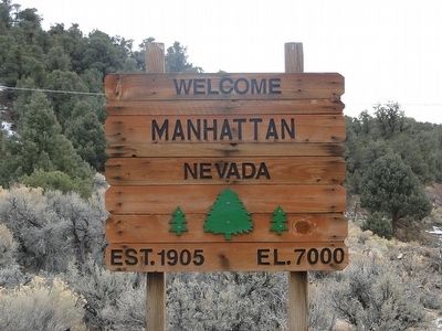
On Highway 376 at Highway 377, on the left when traveling north on Highway 376.
The Manhattan Mining Camp northeast of here, was first organized in 1867. The place name persisted in local use, and was adopted in 1905 when John Humphrey found gold at the foot of April Fool Hill near the old stage route. A typical boom . . . — — Map (db m89409) HM
On U.S. 95, 1.8 miles west of Mercury Highway, on the right when traveling west.
Tests of devices for defense and for peaceful uses of nuclear explosives have been conducted here
since the 1950s. The nation's principal nuclear explosives testing laboratory was located within
this 1,350 square mile, geologically complex . . . — — Map (db m32982) HM
Near 3rd Street east of East Street, on the left when traveling east.
Chief Tecopa was a young man when the first white man came to Southern Nevada. As the leader of the Southern Paiute Tribes, he fought with vigor to save their land and traditional way of life. He soon realized, however, that if his people were to . . . — — Map (db m89415) HM
On MCR926493 Road 0.1 miles east of Rhyolite Road, on the left when traveling east.
Construction on the Adobe Dance
Hall was completed in May 1905.
As its name implies, the hall was
constructed of local stone that
was stacked in place and then
mortared together with adobe.
The Adobe Dance Hall was one of
the . . . — — Map (db m261376) HM
On Rhyolite Road 1.5 miles north of Nevada Route 374, on the left when traveling north.
The Cook Bank is the most iconic building in Rhyolite and is one of the most photographed ruins in Nevada.
John Cook and his brother started the John S. Cook & Company Bank in Goldfield, Nevada in January 1905. Later that same year, they . . . — — Map (db m195416) HM
On MCR926493 Road 0.2 miles east of Rhyolite Road, on the left when traveling east.
The so-called Miner's Cabin was
built using "cast-in-place rubble
and adobe" construction which
was typical in Rhyolite.
Cast-in-place construction used
wood blocks and planks to form a
box the length of the desired wall.
Stone and . . . — — Map (db m261373) HM
On Rhyolite Road 1.5 miles north of Nevada Route 374, on the right when traveling north.
Mining is and always has been a
hazardous occupation. Miners
worked long hours underground
sinking shafts and cutting
underground tunnels to reach the
rich ore deposits. Most of this
work was accomplished using
large amounts of blasting . . . — — Map (db m261363) HM
Near MCR926493 Road 0.2 miles east of Rhyolite Road.
The story of Mona Bell is not an uncommon one. Women like her could be found throughout the mining camps of the West. What is uncommon about Mona's story is how her very public death allowed her tale to be told in a time when the identities of . . . — — Map (db m261371) HM
On Rhyolite Road 1.6 miles north of Nevada Route 374, on the left when traveling north.
John Overbury, a native of Orange, New Jersey, came to Nevada in 1902 and made his fortune in the early days of the Tonopah mining boom. Like many of his peers, he came to Rhyolite hoping to be a part of the new, big boom. Local newspapers . . . — — Map (db m261360) HM
On Rhyolite Road 1.6 miles north of Nevada Route 374, on the right when traveling north.
Like many merchants of the time,
the Porter Brothers, Hiram and
Lyman, moved from mining camp
to mining camp, following the
reports of booms and strikes.
In 1902, they opened a painting
business in San Francisco.
Following the . . . — — Map (db m261359) HM
On MCR926493 Road 0.1 miles east of Rhyolite Road, on the left when traveling east.
You are currently standing in the
middle of Rhyolite's Red-Light
District.
Rhyolite was officially surveyed as
a town in February 1905, and a
Board of Trade was organized in
December of that same year.
However, Nye County did . . . — — Map (db m269788) HM
On Rhyolite Road 0.8 miles north of Nevada Route 374, on the left when traveling north.
In 1904 Frank “Shorty” Harris and Ed Cross found green-colored, high grade gold
ore. The resulting gold rush created the Bullfrog District. Its premier community
was Rhyolite. Platted in 1905, it quickly grew into the largest city in . . . — — Map (db m159714) HM
On MCR926493 Road 0.1 miles east of Rhyolite Road, on the left when traveling east.
Rhyolite was not a notoriously bad
town, but some residents were not
strictly law-abiding citizens. There
were gunfights on Golden Street,
brawls, and normal everyday
disputes.
The first gunfight in the growing
town took place on . . . — — Map (db m261355) HM
On Rhyolite Road 1.5 miles north of Nevada Route 374, on the left when traveling north.
This is the second schoolhouse
built in Rhyolite. The first was a
small, wooden building that was
built on two lots that had been
donated expressly for the purpose.
In February 1906, the first school
opened with 26 students. . . . — — Map (db m261361) HM
On Rhyolite Road 1.8 miles north of Nevada Route 374, on the left when traveling north.
In keeping with its prominence as a mining center, Rhyolite was serviced by three railroads: the Las Vegas & Tonopah, the Tonopah & Tidewater, and the Bullfrog-Goldfield.
The Las Vegas & Tonopah Railroad laid one mile of track per day, then . . . — — Map (db m195442) HM
Near Rhyolite Road 1.1 miles north of Nevada Route 374, on the left when traveling north.
Up the hill lies the financial and population core of Rhyolite, capital of Rhyoleind, and trade center for rhyoleir, the rare lighter-than-air mineral that gave the city its power, wealth and, some said, purpose. You'll see bottlehouses built . . . — — Map (db m159718) HM
On Rhyolite Road 1.5 miles north of Nevada Route 374, on the right when traveling north.
William M. Stewart believed in
Rhyolite and invested heavily in
the growing boomtown and local
mines.
When Stewart came to Rhyolite in
1905, he built a law office and a
sprawling mansion, two of the
finest buildings in town.
. . . — — Map (db m269616) HM
On Titus Canyon Road just west of Nevada Route 374, on the left when traveling west.
This adventurous backcountry road, proclaimed in 1926 by one enthusiast "one of the grandest and most rugged drives on the American continent," is a legacy from the spectacular boom and bust of Leadfield, a mining town located along the way. The . . . — — Map (db m160078) HM
On Rhyolite Road 1.4 miles north of Nevada Route 374, on the right when traveling north.
The Tom Kelly Bottle House is one of the few remaining examples of bottle house architecture in the United States.
In Nevada, where wood is scarce and expensive, miners often built their houses with whatever was cheap and readily available. . . . — — Map (db m195690) HM
Near Rhyolite Road 1.4 miles north of Nevada Route 374, on the right when traveling north.
Gold was discovered in this area in 1904. Several
mining camps quickly grew around the
discoveries. The town of Rhyolite was founded
in 1905 and became the city of dreams; dreams
of gold, prosperity, greed, and speculation.
By 1906 . . . — — Map (db m159246) HM
One of many early 1900 gold camps, Round Mountain is unique because: ...It has been a producer for more than 60 years. ...All the gold occurred in free, visible, metallic form. ...Many small, high-grade veins were easily mined with hand tools. . . . — — Map (db m89414) HM
On Veterans Memorial Highway (U.S. 6) at Bryan Avenue, on the left when traveling north on Veterans Memorial Highway.
This statue depicts Big Bill Murphy, hero of the tragic Tonopah Belmont Mine fire that killed 17 miners on February 23, 1911. Murphy went down in the mine cage a number of times to bring up stricken miners.
On the last trip he did not . . . — — Map (db m62320) HM
Life in the early frontier mining camp of Tonopah was primitive and lonely. Most of the population, single men, lived in tents. Though water was hauled in from springs several miles away, food was brought in from great distances by freight teams. By . . . — — Map (db m188165) HM
Near Burro Avenue south of Oddie Avenue, on the right when traveling south.
For Belle to be so involved in the business of mining was unusual. In 1900 women were not allowed to vote, be on juries or hold elected office, and it was certainly socially inappropriate to be involved in "men's work" as heavily as was Bell, but . . . — — Map (db m188147) HM
On Bryan Avenue south of Main Street/Veterans Memorial Highway (U.S. 6), on the right when traveling south.
The mural you are viewing was painted by noted mural
artist, Lee Bowerman of Grand Junction, Colorado and
is dedicated to Nevada Mine Safety in remembrance of
the Belmont Mine Fire of February 23, 1911 and the
heroism of cage tender, William . . . — — Map (db m129265) HM
Built in 1905 at a cost of $27,965.00 by Continental Construction Company. Site selected by commission April 1 and donated by Jim Butler's Tonopah Mining Company. On Tuesday, February 7, 1905 Governor Sparks signed the bill to remove the county . . . — — Map (db m3916) HM
Buried here are many of Tonopah's Pioneer Residents including 14 victims of the Tonopah-Belmont Mine fire of Feb. 23, 1911 as well as the victims of the 1902 “Tonopah Plague”. Cemetery fenced 1979 by Central Nevada Historical Society. — — Map (db m188166) HM
The pile of pipe beside the building is fan pipe which was used to send air down the mine and through the workings for ventilation. The air was supplied by large fans on the surface. The pile of wire on the hill behind the building is banding from . . . — — Map (db m89635) HM
On Burro Avenue, on the right when traveling east.
The Glory Hole was created in 1922 when a large underground stope caved in. It happed in the evening as the mine was only working one shift at a time, no one was hurt. The size of the stope can be judged by the size of the hole. There are many . . . — — Map (db m188142) HM
On Burro Avenue, on the right when traveling east.
It was one thing to blast, drill and muck up the rock underground. It was quite another to get the rock with the riches to the surface. The most obvious solution was to put the rocks in a bucket of some kind and push, or lift it, to get it out of . . . — — Map (db m188151) HM
Look above you to the large headframe of the Mizpah Mine on the hill. Imagine entering a cage at the bottom of that headframe. You would be lowered 1,500 feet (more than a 1/4 of a mile!), the depth of the Mizpah shaft. When you reached the bottom . . . — — Map (db m89625) HM
On Main Street, AKA Veterans Memorial Highway (Route 95) at Oddie Avenue, on the left when traveling north on Main Street, AKA Veterans Memorial Highway.
In May 1900, Jim and Belle Butler came prospecting from their hay ranch at Belmont to stake the claims that gave rise to Tonopah. This was the first silver bonanza of the 20th century. It prompted a mining renaissance and this heritage is Tonopah's . . . — — Map (db m62321) HM
On U.S. 95 1 miles north of US 6 (U.S. 95) when traveling north.
Born - June 13, 1874 Lake Linden, Michigan
Died - March 4, 1931 San Francisco, California
This monument, constructed in 1931 was dedicated in memory of John G. Kirchen. Tonopah businessman and manager of The Tonopah Extension Mining Co. . . . — — Map (db m46508) HM
Tonopah's remote location created an expensive obstacle. Digging the mineral out of the ground was one thing. Transporting it to the mill and eventually the marketplace was another.
Giant Wagons
Large wagons hitched in tandem were . . . — — Map (db m188160) HM
Near North Main Street (U.S. 95) south of Oddie Avenue.
In 1907-08, to celebrate Tonopah's newfound prosperity, Geo Wingfield, Geo Nixon, Bob Govan and the Brougher Brothers collaborated to erect "The best hotel in Nevada". 1931 saw legalized gambling returned and a small casino was opened. 1956 new . . . — — Map (db m89426) HM
Jim and Belle Butler, along with their associates, sold their claims to investors who formed the Tonopah Mining Company of Nevada. In 1902 development began on the Silver Top Claim. A shaft was suck to 700 feet and eventually a wooden headframe was . . . — — Map (db m188164) HM
When the prospectors wandered the Nevada Desert, they looked for specific types and combinations of rock. Often a certain rock, such as quartz in this vicinity, would signal the presence of gold, silver, or other metals which could mean a new . . . — — Map (db m107137) HM
On University Street west of Cross Avenue, on the right when traveling west.
St. Mark's Protestant Episcopal Church, circa 1906, has been placed on the National Register of Historic Places by the United States Department of the Interior.
In continuous use as a house of worship since 1906.
Now housing the Tonopah . . . — — Map (db m311295) HM
The stopes are where the ore bodies were mined out. These show where the veins actually came to the surface. Jim Butler's original discovery was on these veins near the back of the old fire house. The ore bodies averaged about 500' in depth and . . . — — Map (db m89627) HM
On Main Street (U.S. 6/95) at Brougher Avenue, on the right when traveling north on Main Street.
Marjorie Moore Brown worked for Nevada's vote & the Nineteenth Amendment. Suffrage meetings held here at Mizpah Hotel 1912-1914. — — Map (db m223914) HM
Once the ore was mined and sacked, it had to be hauled to the railroad. That task was entrusted to the Teamsters, so called because they drove teams of mules, horses or both. Each Teamster was assisted by a Swamper, who watered and fed . . . — — Map (db m89632) HM
On Burro Avenue, on the right when traveling east.
It didn't matter how long or small a mine was. Miners tools and dynamite had to be hauled in, and ore, tools and miners had to be hoisted out.
The Whim
The simplest hoist - a pully with a rope leading down into the shaft.
The Whip . . . — — Map (db m188137) HM
In the mining west, the most important partner for the prospector was his jackass. Also known as a donkey, burro, ass, jack, jenny, jennet, or, if crossed with a horse, mule or hinny. The jackass was singularly adapted to long treks over rough . . . — — Map (db m259603) HM
A great mystery of the desert is how quickly word travels of a rich mineral strike! The discovery started America's last great mining rush.
Belle and Jim devised a plan to handle the rush. They leased parts of their claim, the richest . . . — — Map (db m89626) HM
On Burro Avenue, on the right when traveling east.
Transporting supplies to the mines and hauling ore and bullion out to the mills and to marker was the job of the railroads. The Tonopah & Goldfield standard gauge railroad arrived in camp on Monday August 16, 1905. With spurs extending to the mines, . . . — — Map (db m188131) HM
In 1900. Jim Butler stopped at a site known as Tonapah, or Little Water, in the Western Shoshone language. Taking a few rock samples, he discovered a mine that led to one of the most important mineral finds of the early twentieth century. As the . . . — — Map (db m52843) HM
On South Erie Main Street (U.S. 95) at Florence Avenue, on the right on South Erie Main Street.
To Jim Butler, District Attorney of Nye County, goes the credit for making the ore discoveries which ended the twenty-year slump in Nevada's economy. Migratory Indian bands originally applied the name Tonopah to a small spring in the nearby San . . . — — Map (db m42454) HM
Eight miles northwest of this point lies what was formerly one of the leading lead-producing districts in the nation. Producing erratically from ore discovery in 1866 to the present (the last mill closed in 1937), Tybo has managed to achieve an . . . — — Map (db m89416) HM
The hidden vein of silver ore in the middle of the road was exposed when the road was bladed in the 1950's. The vein was missed by the old timers and is an example of how all the outcropped veins looked when they were discovered by Jim Butler in May . . . — — Map (db m89633) HM
On Burro Avenue, on the right when traveling east.
Raising thousands of pounds of rock from the depths of the earth required a massive headframe, strong engines and powerful cables to make it all work. The Mizpah had one of the earliest steel headframes. It weighed about 60,000 pounds and could . . . — — Map (db m188116) HM
Built around 1908, this building was used to house coal unloaded from the Tonopah & Goldfield Railroad in Tonopah. The bin was donated by Larry Moss and moved to this location by the Nye County Road Department. — — Map (db m89630) HM
On Mather Overlook Road south of Wheeler Peak Scenic Drive when traveling south.
He laid the foundation of the National Park Service, defining and establishing the policies under which its areas shall be developed and conserved unimpaired for future generations. There will never come an end to the good that he has done. — — Map (db m127137) HM
Near Wheeler Peak Scenic Drive, on the right when traveling west.
In 1872 gold was discovered three miles northwest of what is today Great Basin National Park. In two decades the mining town of Osceola grew to a population of more than 1500 people and uncovered almost two million dollars work of gold. Though . . . — — Map (db m271581) HM
Here, at one time, was the largest town in White Pine County. Part of the Cherry Creek Mining District, Cherry Creek’s years of largest gold and silver production were between 1872 and 1883. At the peak of its prosperity, the town had an estimated . . . — — Map (db m1370) HM
Built when Cherry Creek was founded in 1872, it is one of the two oldest standing Nevada schoolhouses. In November 1894 a dispute between Pat Green and Pat Dolan over the building’s location turned violent with Dolan killing Green in a gunfight. . . . — — Map (db m1293) HM
On Aultman Street at 7th Street, on the left when traveling west on Aultman Street.
James H. Simpson put the future site of Ely on the map during his 1859 exploration through the Great Basin. In the 1860's, silver and gold deposits were discovered nearby in what became the Robinson Mining District. Ely developed as a regional . . . — — Map (db m69490) HM
The mines of the White Pine District were first discovered in 1865 and supported many thriving towns during the period 1868-1875. The most famous of these early towns was Hamilton, but there were others adjacent, such as Eberhardt, Treasure City . . . — — Map (db m251577) HM
On Lincoln Highway (U.S. 50) near Local Road 401, on the right when traveling west.
The mines of the White Pine district were first established in 1865. Between 1868 and 1875, they supported many thriving towns including Hamilton, Eberhardt, Treasure City, and Shermantown. These communities, now all ghost towns, are clustered . . . — — Map (db m290323) HM
In May-June, 1827, Jedediah Smith attempted to find a route from California’s central valley to the Great Salt Lake Valley in Utah, and he became the first European to completely cross what is now Nevada. Because Smith’s journal and map have never . . . — — Map (db m1302) HM
Near Cave Valley Road (County Road 45) 1 mile south of County Road 16 when traveling west.
The charcoal making process took a total of 13 days and 35 cords of wood, from the time each oven was filled, burned, and then emptied. The wood was hauled by wagons or hand carts to the front of the oven, and the process of layering the wood . . . — — Map (db m127176) HM
On Aultman Street at Odgen Avenue, on the right when traveling west on Aultman Street.
Mark Requa's Nevada Consolidated Copper Company built a 150-mile line from Cobre on the Southern Pacific to Ely in 1905-06 to haul ore from Copper Flat mines west of Ely.
Ore was loaded into railroad gondolas at Copper Flat for the trip to the . . . — — Map (db m69489) HM
On U.S. 6 at milepost 72.7, on the right when traveling east.
Osceola, most famous of the White Pine County gold producers, was probably the longest-lived placer camp in Nevada.
The gold-bearing quartz belt found in 1872 was 12 miles long by 7 miles wide. Placer gold was found in 1877 in a deep ravine . . . — — Map (db m69492) HM
On U.S. 93 at milepost 93, on the right when traveling north.
Schellbourne, in the foothills of the Schell Creek Range, was a Shoshone village site long before it began its recent historic career in 1859. Captain James Simpson passed through the site and this point, looking for a short route across the Great . . . — — Map (db m1304) HM
On U.S. 6/50/93 near White Pine County Road 19, on the right when traveling south.
Silver and gold were discovered in 1873, in what was to become Taylor, a typical mining community supported chiefly by the Argus and Monitor Mines. In 7 years, the town boasted a population of 1500 people, 7 saloons, 3 general stores, an opera . . . — — Map (db m27289) HM
On East Aultman Street (Lincoln Highway) (U.S. 50) at 4th Street, on the right when traveling east on East Aultman Street (Lincoln Highway).
Digging began on the Liberty Pit in 1908, the same time that the Nevada Northern Railway tracks reached Copper Flat from Ely.
When work started, the pit was not a pit at all, but two small hills instead. The old map below shows the original . . . — — Map (db m126499) HM
The life histories of 46 residents of the Ward Cemetery tell a fascinating story about what life was like in the early mining boom towns of White Pine County. Most residents of Ward were not native to the area. Many came from as far away as China . . . — — Map (db m69487) HM
Near Cave Valley Road (County Route 45) 1 mile south of County Road 16.
Willow creek, a year round stream located 1/4 mile to the north, was a major stopover for freighters on the Toano to Pioche route between 1870 and 1876. "Bullwhackers" (common term for freighters) would turn out their "Sleepers" (tired oxen) in this . . . — — Map (db m68763) HM
Near Cave Valley Road (County Road 45) 1 mile south of County Road 16.
These ovens were constructed during the mid 1870's and are larger and of finer construction than most other ovens found in Nevada. They are 27 feet in diameter and 30 feet high with a capacity of about 35 cords of wood which was burned for a period . . . — — Map (db m62118) HM
The ghost town of Ward, in the foothills of the Egan Range, lies some eight miles west of here. Booming from 1876 until 1882, with a peak population of 1,500, Ward was somewhat of a lawless mining camp. Early killings did occur, but justice was . . . — — Map (db m27291) HM
On Main Street (Nevada Route 318) at 1st South, on the right when traveling north on Main Street.
In 1882, Congress passed the Edmunds Act causing L.D.S. Church property to be confiscated, including cattle which the receiver leased to Nichols and Parsons. Later the law was repealed and church property returned. The lessees could not fully repay . . . — — Map (db m1301) HM
Near U.S. 93 at White Pine County Road 18 ( Route 893), on the right when traveling north.
Before Schellbourne: Before the Lincoln Highway, before the Pony Express, and before wagon trains rolled across the plains, the Kusiutta people (the Goshute people) lived here. This desert home has made survival difficult, but the extreme . . . — — Map (db m67832) HM
Near U.S. 93 at White Pine County Road 18 ( Route 893), on the right when traveling north.
The first teams of Pony Express riders amazed the nation by accomplishing their east and west bound deliveries within the projected 10 day schedule. The speed of the riders even had a role in swaying a divided California to stay with the union . . . — — Map (db m67128) HM
Near U.S. 93 at White Pine County Road 18 ( Route 893), on the right when traveling north.
Descriptions of the variety and number of horses used by the Pony Express became distorted during the course of its history since November 1861. In general, the type of horse used for carrying the rider and mail depended greatly on the region. The . . . — — Map (db m67127) HM
Near U.S. 93 at White Pine County Road 18 ( Route 893), on the right when traveling north.
In 1845, it took six months to get a message from the East Coast of the United States to California. By the late 1850s, a half million people had migrated west and were demanding up-to-date news from home. Something had to be done to deliver mail . . . — — Map (db m67129) HM
Near U.S. 93 at White Pine County Road 18 ( Route 893), on the right when traveling north.
The Visionary: Carl Fisher was a dreamer with an entrepreneurial spirit. After amassing a large fortune and building a reputation in the auto-parts industry, Fisher began to dream of building a paved hard-surface, coast-to-coast highway. He . . . — — Map (db m67131) HM
Near U.S. 93 at White Pine County Road 18 (Route 893), on the right when traveling north.
Mail From Coast to Coast: During the mid-1800s, American settlers were on the move, relocating from crowded Eastern cities to the untamed wilderness of the West. Many made their way to California. With the surge of settlers, California began . . . — — Map (db m67130) HM
On U.S. 50 at milepost 61.5 at Route 267, on the left when traveling west on U.S. 50.
1864–1964. The famed open-pit copper mines of Eastern Nevada including the Liberty Pit, largest in the state, are located two miles south of this point. Through the first half of the 20th century, this area produced nearly a billion . . . — — Map (db m69494) HM
Passed Antelope to Rock Springs, where coming out of a rock is a stream of the coldest, purest water. Some one has driven a spigot into the crevice, making a spout…the most desirable camp of the journey." - William Carter Moss, Aug 2, 1861 — — Map (db m249470) HM
On White Pine County Road (County Road 3) 53.7 miles north of U.S. 50, on the right when traveling north.
Colonel P. Edward Connor was ordered to build and command this post in 1862. The fort was built midway between Salt Lake City, Utah and Carson City, Nevada to protect the Overland Mail Route (Pony Express) and emigrant travelers from Indian raiders. . . . — — Map (db m74710) HM
183 entries matched your criteria. Entries 101 through 183 are listed above. ⊲ Previous 100