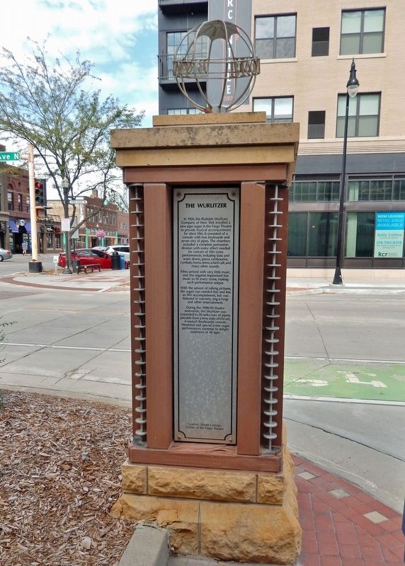
On 4th Avenue North at Broadway North, on the left when traveling west on 4th Avenue North.
In 1926, the Rudolph Wurlitzer Company of New York installed a new pipe organ in the Fargo Theatre to provide musical accompaniment for silent film. It consisted of a console with two keyboards and seven sets of pipes. The chambers included a . . . — — Map (db m240095) HM
On 4th Avenue North at Broadway North, on the right when traveling east on 4th Avenue North.
Early FargoReynold's Variety House and Shea's Variety House were known for their dancing girls, ribald comedians, food and drink. Pinkham's Hall and Egbert's Hall served a variety of purposes including school, church services and theater. . . . — — Map (db m240073) HM
On Main Avenue (U.S. 10) at 7th Street South, on the right when traveling east on Main Avenue.
N.D. Votes For Women League Office on third floor of Delendrecie Bldg. 1912-1918. Suffragists worked here for voting rights for women. — — Map (db m205236) HM
On 2nd Avenue North at Broadway North, on the right when traveling east on 2nd Avenue North.
Early explorers to the Red River Valley discovered a wide range of wildlife living along the Red River. One could have easily spotted a moose, American elk, mink or even a black bear. Although these animals may be uncommon now, there is a variety . . . — — Map (db m240286) HM
Near North University Drive just south of Centennial Boulevard, on the right when traveling south.
This dormitory, completed in 1931, was rededicated and named June 10, 1957, in honor of Omar O. Churchill respected staff member who also served for two years as acting Dean of the School of Agriculture during the period 1904-1950. Doctor Churchill . . . — — Map (db m290074) HM
On Albrecht Boulevard 0.1 miles north of 12th Avenue North (North Dakota Route 294), on the left when traveling north.
Originally known as Science Hall, this building was begun in 1901 with additions in 1917 and 1930. It was renamed on June 4, 1951 in honor of Archibald Ellsworth Minard 1878-1950 whose faithful and devoted service to the college extended from . . . — — Map (db m299400) HM
On 44th Street S. at 20th Ave. S. on 44th Street S..
Welcome to Fargo-Moorhead's most notorious photo op!
This is a "stunt double" for the equipment used in a key concluding scene of the movie FARGO.
Feel free to pose for a picture and share your experience online.
Step inside the FM . . . — — Map (db m102057) HM
Founded in 1989 by Fargo printer, Mike Stevens, the walk of fame was originally located on the city sidewalks of Mike's print shop, Express Press, in downtown Fargo. It was moved to the current site during the summer of 2000. The first inductee . . . — — Map (db m102055) HM
Near 45th Street South just south of 15th Avenue South, on the right when traveling south.
The son of a Kentucky frontiersman, Lincoln had to struggle for a living and for learning. Five months before receiving his party's nomination for President, he sketched his life: "I was born February 12, 1809, in Hardin County, Kentucky. My . . . — — Map (db m238199) HM
Near 45th Street South just south of 15th Avenue South, on the right when traveling south.
On April 30, 1789, George Washington, standing on the balcony of Federal Hall on Wall Street in New York, took his oath of office as the first President of the United States. Born in 1732, into a Virginia planter family, he learned the morals, . . . — — Map (db m238197) HM
Near 45th Street South just south of 15th Avenue South, on the right when traveling south.
On February 6, 1911, Ronald Wilson Reagan was born to Nelle and John Reagan in Tampico, Illinois. He attended high school in nearby Dixon and then worked his way through Eureka College. There, he studied economics and sociology, played on the . . . — — Map (db m238200) HM
Near 45th Street South just south of 15th Avenue South, on the right when traveling south.
Author of the Declaration of Independence and the Statute of Virginia for Religious Freedom, third president of the United States, and founder of the University of Virginia — voiced the aspirations of a new America as no other individual of his . . . — — Map (db m238198) HM
On 150th Avenue Southeast near 47th Street Southeast, on the left when traveling south.
The Maple Creek crossing at old Watson was probably used as early as 1825 by Selkirk colonists moving from Pembina area to Fort Snelling. They were followed in 1843 by the fur brigades of Kittson and Rolette. Major Woods crossed here in 1849, en . . . — — Map (db m175424) HM
On Main Avenue West (U.S. 10) east of 21st Street Northwest, on the right when traveling east.
Pioneers first settled in the area that later became Kathryn, North Dakota as early as 1876. As the Northern Pacific Railroad constructed the Casselton-Marion spur line, a man named John Runck joined a civil engineer to plat land he purchased from . . . — — Map (db m279296) HM
Jews have been part of North Dakota's social, economic, agricultural and political life since territorial days. Between the 1880's and the 1920's, aided by the Jewish Agricultural and Industrial Society, primarily Russian and Romanian Jews came to . . . — — Map (db m134335) HM
Near Main Avenue West (U.S. 10) east of 21st Street NW, on the right when traveling east.
This tablet marks the site where Generals Grant and Sheridan stopped September 4th 1883, with a party enroute west to drive the Golden Spike which completed the Northern Pacific Railroad. — — Map (db m209097) HM
Near Main Avenue West (U.S. 10) east of 21st Street Northwest, on the right when traveling east.
Drugstores offered their communities much more than prescriptions and other medical
products. The display features original furnishings from Norwegian immigrant Lars P. Bjerklie's drugstore from Gilby, North Dakota that he operated from 1889 to . . . — — Map (db m278933) HM
Near Main Avenue West (U.S. 10) east of 21st Street Northwest, on the right when traveling east.
Elbert Heale "Jappe" Trenaman, born in Canada in 1874, came to Page, North Dakota with his mother in the 1880s. He and an
associate named Shinn opened the Brass Rail, a spot that residents remembered as one of the best-known places for meals. . . . — — Map (db m278925) HM
Near Main Avenue West (U.S. 10) near 21st Street Northwest, on the right when traveling east.
One of the last remaining circular town bandstands that stood in the Buffalo park. This one from Buffalo, ND is now restored and stands proudly at Bonanzaville, USA. — — Map (db m278818) HM
Near Main Avenue West east of 21st Street Northwest, on the right when traveling east.
Fargo's current county courthouse is the third courthouse constructed for the town.
The first opened in 1877 and later served as a YMCA building and boarding house. The
second replaced the first in the mid-1880s and burned down during renovations . . . — — Map (db m278870) HM
Near Main Avenue West (U.S. 10) east of 21st Street Northwest, on the right when traveling east.
1906
Cass County District Court
Restoration made possible by a grant from the Alex Stern Family Foundation, given in memory of Alex Stern, Bertha Stern, William Stern, Sam Stern, Helen Stern and Edward A. Stern, A. M. Eriksmoen, . . . — — Map (db m278823) HM
Near Main Avenue West (U.S. 10) east of 21st Street Northwest, on the right when traveling east.
The Cass-Clay Creamery was built on site at Bonanzaville in 1984 and designed to resemble a former 1930s creamery from Kenmare, North Dakota. Much of its interior and equipment comes from the Cass-Clay Cooperative Creamery headquartered in Fargo. . . . — — Map (db m278927) HM
Near Main Avenue West (U.S. 10) near 21st Street Northwest, on the right when traveling east.
A bonanza farm home from Mapleton Township. Home of Mary Dodge Woodward. She kept a diary here accurately recording pioneer life. From this, her granddaughter wrote the book "The Checkered Years". — — Map (db m278820) HM
Near Main Avenue West (U.S. 10) east of 21st Street Northwest, on the right when traveling east.
The cook car, or "cooker," was a mobile kitchen used to provide onsite meals for workers. They were transported out into fields during harvest season or to active construction sites where cook car staff would prepare and serve hot meals. Cook cars . . . — — Map (db m278931) HM
Near Main Avenue West (U.S. 10) east of 21st Street Northwest, on the right when traveling east.
One-room schoolhouses were common features on the Great Plains during the late-
nineteenth and early-twentieth centuries. Settlers constructed many of the first schools and they used readily available materials like sod or wooden logs. The . . . — — Map (db m278819) HM
On Main Avenue West (U.S. 10) east of 21st Street Northwest, on the right when traveling east.
The Embden Depot was built in 1900. The town of Embden moved from its original location near the farm of Enos Gray,
the postmaster of Embden, to a spot along a new spur line of the Northern Pacific Railroad. The new line through Embden
was called . . . — — Map (db m278707) HM
Near Main Avenue West (U.S. 10) east of 21st Street Northwest, on the right when traveling east.
Land claims in Fargo, North Dakota were filed soon after it was determined the
railroad would cross at that point. Homesteader A. H. (Harry) Moore entered the Red River Valley area in 1869 and filed one of the earliest claims. Moore built an oak . . . — — Map (db m278744) HM
On Main Avenue West (U.S. 10) east of 21st Street Northwest, on the right when traveling east.
Christian Furnberg was a young boy when he and his mother moved to Dakota Territory
in 1871. As a boy, Christian would peddle goods to people in the area, shortly after getting married, Christian borrowed $50.00 from his sister-in-law to open a . . . — — Map (db m278748) HM
On Main Avenue West (U.S. 10) east of 21st Street Northwest, on the right when traveling east.
Martin Habberstad came to Houston County, Minnesota from Eidsvoll, Norway in 1869 and his wife Mary (Tosterud) Habberstad followed in 1871. Martin entered Cass County, North Dakota searching for farmland in early 1875. He chose a spot
near Kindred . . . — — Map (db m278776) HM
Near Main Avenue West (U.S. 10) at 21st Street Northwest, on the right when traveling east.
Martin Hendrickson Hagen emigrated from Norway with his parents and they first settled in Springfield, Minnesota. Martin
moved to a homestead southwest of Horace with his wife Helene Larsen in 1887. The Hagens built a home there in 1897 where they . . . — — Map (db m278822) HM
Near Main Avenue West (U.S. 10) east of 21st Street Northwest, on the right when traveling east.
Addison, North Dakota was a Great Northern Railroad station first named Williams when established in 1880 for nearby bonanza farmer H. M. Williams. Pioneer Addison Leech, Sr. later bought Williams' farmland and the township was renamed Addison in . . . — — Map (db m278935) HM
Near Main Avenue West (U.S. 10) east of 21st Street Northwest, on the right when traveling east.
David Henderson Houston was born in Glasgow, Scotland on June 14, 1841 and came with his farming parents to Cambria, Wisconsin. David entered the Dakota Territory in 1879 searching for farmland and chose a homestead and timber claim south of Hunter, . . . — — Map (db m278875) HM
Near Main Avenue West (U.S. 10) east of 21st Street Northwest, on the right when traveling east.
Hunter's first newspaper, The Hunter Hawk, began in 1883 and was published by local surgeon Dr. Charles McKay. Following Dr. McKay, Henry and Charles Stone took over and published The Eye from 1885 until 1891 when they started a new newspaper in . . . — — Map (db m278727) HM
On Main Avenue West (U.S. 10) east of 21st Street Northwest, on the right when traveling east.
In early spring 1882, homesteaders Francis Rogers and Henry McCarten formed a party of settlers that entered Brown County, North Dakota to file land claims. Members of this party were the first settlers of Sargent Township. The township was platted . . . — — Map (db m278768) HM
On Main Avenue West (U.S. 10) east of 21st Street Northwest, on the right when traveling east.
This is a replica of a Cogswell, ND building.
With the Homestead Act of 1862, hopeful new land seekers were required to register their applications for new plots with the land office. The land office would then provide titles to their property . . . — — Map (db m278773) HM
Near Main Avenue West (U.S. 10) east of 21, on the right when traveling east.
An Elm Tree in Boston became known as The Liberty Tree. This tree became a rallying point for the growing resistance to the rule of Britain over the American Colonies. In 1765, Patriots in Boston staged the first act of defiance against the British . . . — — Map (db m278879) HM
Near Main Avenue West (U.S. 10) east of 21st Street Northwest, on the right when traveling east.
German homesteaders John and Dora Maier left Odessa, Russia and entered Eureka, South Dakota in the late 1880s. They first farmed near fellow Germans from Russia before moving to Moorhead, Minnesota. The Maier's built a house on their new homestead . . . — — Map (db m278723) HM
Near Main Avenue West (U.S. 10) east of 21st Street Northwest, on the right when traveling east.
The Martinson Cabin was originally a barn built in 1913 on the shore of Pelican Lake. It was built by either Laura A. Schave or Carl Torstenson as both owned the plat of land during that time. Older residents recalled it served as a lodge for local . . . — — Map (db m278887) HM
Near Main Avenue West (U.S. 10) east of 21st Street Northwest, on the right when traveling east.
Named after Donald Moum, the Ag Building was erected in 1996. It contains a collection of agricultural technology that was used and developed in our region. In addition to threshing machines, plows, and seeders, the beginnings of agricultural . . . — — Map (db m278920) HM
On Main Avenue West (U.S. 10) just east of 21st Street Northwest, on the right when traveling east.
This garden is a living tribute to all of America's veterans and their families. In silence and respect, this is a place to remember why millions of Americans have fought and died for our liberty and our freedom.
Here we renew our promise to . . . — — Map (db m278877) WM
Near Main Avenue West (U.S. 10) east of 21st Street Northwest, on the right when traveling east.
Since Fargo, North Dakota has had a formal government, there has been some form of fire protection for the city. The first Mayor, George Egbert, appointed Barney Griffin and L. B. Cornwall as the first two fire wardens on April 12, 1875. Early . . . — — Map (db m278922) HM
On Main Avenue West (U.S. 10) east of 21st, on the right when traveling east.
St. John's Lutheran Church was located northwest of Horace, North Dakota. It played a very important role in the spiritual and social lives of the people of Horace and the surrounding areas. St John's was originally part of the Sheyenne . . . — — Map (db m278777) HM
On Main Avenue West (U.S. 10) east of 21st Street Northwest, on the right when traveling east.
This marker commemorates the men and women who achieved American independence. These Patriots, believing in the noble cause of liberty, fought valiantly to found a new nation. 1775-1783
Presented by
North Dakota State Society . . . — — Map (db m278878) WM
On Main Avenue West (U.S. 10) east of 21st Street Northwest, on the right when traveling east.
In 1870, permanent settlers first established homes near the Wild Rice River in what later became the Eagle Township. More homesteads were filed along the tracks of the Fargo & Southern Railroad, which later became the Chicago, Milwaukee, St. Paul . . . — — Map (db m278817) HM
On Main Avenue West (U.S. 10) east of 21st Street Northwest, on the right when traveling east.
Peder Borderud, Simon Hanson, Simon's nephew John Rustad, and Ole Svengaard
visited the Red River Valley from Mitchell County, Iowa to examine homestead
possibilities in 1870. They returned to Iowa and came back to the Red River Valley
with more . . . — — Map (db m278881) HM
Near Main Avenue West (U.S. 10) east of 21st Street Northwest, on the right when traveling east.
The Trangsruds were an early pioneering family in Cass County. Hans and Berte
Trangsrud immigrated from Oslo, Norway to America with their children: Amund,
Bernard, Axel, and Bertia in 1870. The family first settled in Mitchell County, Iowa and . . . — — Map (db m278880) HM
On Main Avenue West (U.S. 10) east of 21st Street Northwest, on the right when traveling east.
Built around 1900, this barber shop was originally located in Buffalo, ND. W.J. Frederick first operated it as the "City Tonsorial Parlor." From 1909-1964, Lewis Easton owned and operated it as the "U-R Next Barber Shop." Easton was also a law . . . — — Map (db m278721) HM
On Main Avenue West (U.S. 10) east of 21st Street Northwest, on the right when traveling east.
The U-R Next Barbershop first operated in 1900 as W. J. Frederick's "City Tonsorial Parlor" in Buffalo, North Dakota. It was located on a corner lot where the R. Stiles Hotel once stood in 1879 for settlers who came to file land claims. In 1909, . . . — — Map (db m278718) HM
On State Highway 16 0.5 miles east of Interstate 29, on the right when traveling east.
Cass County Board of Commissioners
H. Eklund - Chairman
I. Sandbeck - L. Younker
L. Sutton - W. Bailey
County Engineer - A. Cousins
Built By
Jardine Bridge Co., Inc. Fargo, North Dakota
Historic Bridge
The above plaque was taken . . . — — Map (db m91441) HM
On 3rd Street at 8th Avenue, on the left when traveling south on 3rd Street.
1887 Patrick McHugh 1888 Joseph B. Boyd • Established retail store at this site 1925 John J. & Richard Boyd • Golden Rule Store 1936 Kathren Boyd 1974 Richard S. Johnson • JC Penny Store 1992 Jon Brosseau 2000 Wm. Bodelson, Hans & Diane . . . — — Map (db m206400) HM
On 8th Avenue at 3rd Street, on the right when traveling west on 8th Avenue.
When Cavalier County was being settled in the 1880s, spring wheat and durum were the primary crops. Other crops produced were barley, flax, and oats. Major changes in farming operations took place in the 1910s. On-farm grain storage became . . . — — Map (db m214097) HM
On 8th Avenue at 3rd Street, on the right when traveling west on 8th Avenue.
Alsen/Storlie (est. 1905) This Soo Line Railroad townsite was named for local settlers who came from Alsen Island off the coast of Denmark. Alsen reached a peak population of 358 in 1930. Ambro (1891-1901) This small Bohemian settlement . . . — — Map (db m214096) HM
On 8th Avenue at 3rd Street, on the right when traveling west on 8th Avenue.
1738 • The first known white, non-native men to have set foot in Cavalier County were those in the Verendrye expedition. Through researching journals, it is believed that the expedition passed through Cavalier County in November of 1738 and . . . — — Map (db m214094) HM
On 8th Avenue at 3rd Street, on the right when traveling west on 8th Avenue.
One of a kind While original plans called for twelve sites, on May 26, 1972, an interim agreement that came out of the Strategic Arms Limitations Talks I (SALT 1) was signed. The Anti-ballistic Missile (ABM) Treaty limited strategic missile . . . — — Map (db m214102) HM
On 3rd Street just north of 8th Avenue, on the left when traveling south.
On this day we honor the memory of those who lost their lives in the Cyclone of May 29, 1909 Mrs. J.B. (Gertrude) Boyd Mrs. F.W. (Rebecca) Bleakley Donalda Sheehan Agnes Bain Joseph Power, Jr. and give thanks for those who persevered to rebuild . . . — — Map (db m206431) HM
On 8th Avenue at 3rd Street, on the right when traveling west on 8th Avenue.
Not much is known of the very early history of Cavalier County. The Sioux are believed to have been the earliest residents. The first known white men to have set foot in Cavalier County were those in the Verendrye expedition, which camped in the . . . — — Map (db m214095) HM
On 8th Avenue at 3rd Street, on the right when traveling west on 8th Avenue.
In a 1974 North Dakota State University interview-poll of long-time residents, newcomers, and local officials, four out of five respondents indicated that the overall effect of the Safeguard project had been beneficial in terms of the . . . — — Map (db m214104) HM
On 8th Avenue at 3rd Street, on the right when traveling west on 8th Avenue.
Located along the northeastern edge of North Dakota, just south of the US-Canadian border, Cavalier County is a vibrant, thriving place to live, work, and visit. As of 2020, population was estimated at 3,800. Agriculture drives the local economy . . . — — Map (db m214098) HM
On 8th Avenue at 3rd Street, on the right when traveling west on 8th Avenue.
Ballistic Missile Development WWII spurred a huge leap in missile technology. During the last months of WWII, the Germans introduced the V2, which is considered the first ballistic missile. At the conclusion of WWII, German V1 and V2 rockets . . . — — Map (db m214099) HM
On 8th Avenue at 3rd Street, on the right when traveling west on 8th Avenue.
1 • The Perimeter Acquisition Radar (PAR) performed long-range surveillance detection and tracking of ICBMs for interception. The PAR scanned an area of more than 1,000 miles for incoming missiles over the North Pole. Identified . . . — — Map (db m214103) HM
On 78th Street Southeast at County Road 60, on the left when traveling west on 78th Street Southeast.
Map insetThe pristine 35 miles of the Charles SanSan Trail / James River Valley Scenic Byway offers visitors splendid views of unspoiled, rich North Dakota landscapes. Along the route are many scenic and historic places to . . . — — Map (db m279335) HM
Built in 1891 by Oakes Methodists, this building was a block south of Main on Highway 1. When a larger church was needed in 1908, the Methodists built the present structure at 6th and Juniper and sold the original church to the Norwegian & . . . — — Map (db m112569) HM
On 108th Avenue Southeast at 91st St SE, on the right when traveling north on 108th Avenue Southeast.
Established in the spring of 1883 by a colony from New York state and named for the Hudson River. A railroad right-of-way was planned to serve the town from the east. Three years later the Northern Pacific and Northwestern railways met on the . . . — — Map (db m175276) HM
Near 85th Street Southeast 0.3 miles west of 110th Ave SE, on the left when traveling west.
1/5 mile to the south is the site of the Stagecoach Relay Station. Benjamine and Mellinger operated the stage line, beginning in 1880, between Columbia, SD and Jamestown, ND. Service took two days each way and passengers could be fed and lodged . . . — — Map (db m112568) HM
Near 5th Avenue Southwest at 6th Street West, on the right when traveling west.
Some gave their all, Some gave their life. Divide County History: The earliest inhabitants of what became Divide County included natives of the Assiniboine tribe, dating back to prehistoric time. They crossed the area as they . . . — — Map (db m202740) HM WM
On 94th Street Northwest, on the left when traveling east.
Writing Rock State Historic Site fuels the imagination. Carved into
two granite boulders at the site are figures that probably represent
a mythological thunderbird. These stone carvings are called
petroglyphs. Thunderbirds were sacred figures . . . — — Map (db m288745) HM
In 1989, inspection of the Lake Ilo dam found that critical maintenance was needed. A notch cut into the spillway lowered the water about 7 feet so the work could be completed. The exposed lake bed revealed remarkable discoveries and mysteries of . . . — — Map (db m153143) HM
On 5th Street SW 0.3 miles south of 4th Street SW, on the right when traveling south.
Chelsey and Polly Dinkins played a major role in the construction and operation of this dam and National Wildlife Refuge known as Lake Ilo.
Chelsey Dinkins was the foreman of the Works Progress Administrations (WPA) crew that built the dam in . . . — — Map (db m152944) HM
On Killdeer Mount Battlefield Road, on the right when traveling north.
On July 28, 1864, a U.S. military force, commanded by General Alfred Sully, attacked several groups of the Dakota, Nakota, and Lakota (Sioux) Nations camped at this location. Major Sioux leaders included Medicine Bear and Sitting Bull. Sully's . . . — — Map (db m285850) HM
On State Highway 22 at milepost 126 near County Road 14, on the left when traveling south.
More than a few ranchers have probably had to look for a lost cow in this country, but few people would
suppose that even the world's most famous badlands were a place where you could lose a bridge.
A new bridge was built just downstream from . . . — — Map (db m252889) HM
Near State Highway 22 at milepost 944 near !st Street Southwest, on the left when traveling south.
Three panels make up this marker
Rodeo!
Modern rodeo is big business, but at its heart rodeo is still a working class sport of small western towns, dusty pickup trucks and cowboys doing the things they love to do.
The . . . — — Map (db m252892) HM
On 100th Street SouthWest near State Highway 1804.
Sunday, October 14, 1804
...journeying about 12 miles...
...bank opposite an...
...of an early Indian wall...
...75 lashes for insubordination,,,
...by a court martial...
..[Eagle] Feather, who was traveling with . . . — — Map (db m285609) HM
On Main Street just east of Cook Avenue, on the right when traveling east.
The Hazelton Post Office was established July 6, 1903. It was located at this site in the home of Elise Longpre Perras. In December of 1903 the nearby Williamsport Post Office (Williamsport, N.D. about 3 ½ miles N.E. of Hazelton) closed and its . . . — — Map (db m231462) HM
On Broadway Street North at East Maple Avenue, on the right when traveling north on Broadway Street North.
Darwin Reed Streeter, left, founded the Emmons County Record on June 10, 1884, at Williamsport, Dakota Territory, and the Emmons County Republican/Braddock News in 1899. His son, Frank, right, was the first editor in Braddock and, in 1912, . . . — — Map (db m231458) HM
On 4th Street Northeast (State Highway 16) just east of North Central Avenue, on the left when traveling east.
The Yellowstone Expedition of 1876 organized to quell the hostile Sioux marched from Fort Abraham Lincoln May 17, 1876 and passed within three fourths of a mile to the south of this marker on June 3, 1876. Between Sentinel Butte and Beach . . . — — Map (db m202891) HM
On 1st Avenue Southeast south of 1st Street Southeast, on the right when traveling south.
Clara Darrow, President N.D. Votes For Women League, spoke to crowd in Beach Sept. 1914 during suffrage campaign throughout state. — — Map (db m202885) HM
This commemorative plaque is placed in honor of the work performed by Company's 2770, 4737, and 764 of the Civilian Conservation Corp (CCC) between 1934 and 1941 under the direction of the Nat'l Park Service. While the main project of these crews . . . — — Map (db m183703) HM
On North 3rd Street at 1st Avenue North on North 3rd Street.
The Red River Valley is well known for long, harsh winters, But the winter of 1996-97 was unlike any before. Eight blizzards battered the area during a seemingly endless winter. The blizzards, which the Grand Forks Herald named, started with . . . — — Map (db m169712) HM
On North 3rd Street at 2nd Avenue North, on the right when traveling north on North 3rd Street.
The flood showed how powerless man is against nature. It also reaffirmed the sheer strength of the human spirit.
Even before the water receded, material goods and money flowed in, gifts from across the land to the people of a small community . . . — — Map (db m169725) HM
In 2002, Mayor Michael R. Brown accepted the gracious donation by Xcel Energy of plaques chronicling the events of the Great Flood of 1997. They were originally dedicated, on the fifth anniversary of the flood, as a permanent gift to the . . . — — Map (db m169727) HM
Near South 4th Street at Bruce Avenue, on the left when traveling north.
Considered the Founder of Grand Forks, Alexander Griggs filed the first land plat in the Original Townsite in 1875. Steamboat captain and builder, Griggs was an integral part of the steamboat era. He learned his navigational skills on the . . . — — Map (db m162628) HM
On North 3rd Street at 1st Avenue North on North 3rd Street.
On April 4, "Hannah" swept in, bringing a thick coat of ice that covered everything, followed by seven inches of wet, heavy snow, 70 mile per hour winds, and subzero temperatures.
The flood fight halted. Sandbags froze. Powerlines fell as . . . — — Map (db m169713) HM
First built as a township hall in 1917, this building became Grand Forks County's Blooming 46 school house in 1930. At a time when most Americans lived in rural areas, these one room school houses served as the primary source for education of . . . — — Map (db m183700) HM
Thomas and Almira Campbell emigrated from Perth, Ontario in 1875. They started their farm on this site with eighty acres of land and a sod shanty. In 1879, they built the log cabin that is the original part of the Campbell House. An addition was . . . — — Map (db m183663) HM
On DeMers Avenue (Business U.S. 2) just east of South 5th Street, on the right when traveling east.
The Clifford Annex was constructed by Dinnie Brothers Construction Company during the last surge of 19th century commercial building, which replaced most of the original wood frame buildings in downtown Grand Forks. The architecture has been . . . — — Map (db m213947) HM
The rising water brought crisis. It left behand devastation.
As residents returned to their homes, they found what no television or newspaper could fully capture. Water and mud had seeped onto everything. Garbage was everywhere. The smells . . . — — Map (db m169726) HM
On North Third Street at 2nd Avenue North on North Third Street.
The Dinnie Block was constructed by Dinnie Brothers Construction Company, a firm that played a significant role in the look of the Grand Forks business district in the early 20th century. The three-story building featured locally manufactured . . . — — Map (db m169722) HM
On South 4th Street just south of DeMers Avenue (Business U.S. 2), on the right when traveling south.
This building was considered one of the best examples of pre-World War I commercial architecture in Grand Forks. The two story structure was built of dark red Hebron brick accented by stone. It remained largely unchanged throughout its life. . . . — — Map (db m213966) HM
On North 3rd Street at 1st Avenue North on North 3rd Street.
Flood predictions from the National Weather Service continued to rise, and a community struggled to keep up. As residents battled the Red River, city officials fought to keep people safe. New and strange sounds engulfed the cities; civil defense . . . — — Map (db m169717) HM
Fannie Mahood was born in Wykoff, MN and moved to Dakota Territory in 1880. She married Frank Heath in 1881. On a 160 acre tree claim west of Grand Forks, they struggled with alkaline soil and drying winds of the treeless prairie. By 1920 their . . . — — Map (db m183665) HM