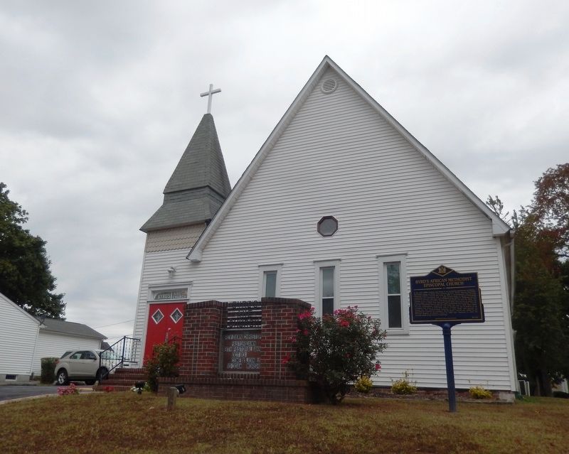
In the early 1890s Clayton was home to an increasing population of African-Americans, many of whom were railroad workers. Byrd's African Methodist Episcopal (A.M.E.) Church was built in 1894 to accommodate this growing community who previously had . . . — — Map (db m141340) HM
Dedicated in honor of those who have served and continue to serve and in memory of the men and women who made the ultimate sacrifice in the defence of our country
In honor of those that have . . . — — Map (db m174553) WM
First known as Smyrna Station, the Town of Clayton began when the railroad came to this area in the mid-1850s. In 1860, the name was changed to honor Delawarean John M. Clayton, a former United States Secretary of State and strong advocate of the . . . — — Map (db m39023) HM
A local society of Methodists was organized circa 1778. On May 16, 1781, they obtained land here on which to build a permanent house of worship. A large frame church was then constructed and named Blackiston's Chapel, to honor the family that . . . — — Map (db m40190) HM
In 1924, the members of the David C. Harrison American Legion Post # 14 initiated the first American Legion ambulance service in the world. Its eighteen founding members were veterans of World War I who volunteered their time to transport the . . . — — Map (db m39026) HM
In 1924, the David C. Harrison American Legion Post #14 in Smyrna formed the first American Legion Ambulance Service in the world. The 18 founding members were veterans of World War I who volunteered to transport sick and injured community members . . . — — Map (db m174556) HM
In 1706 John Allee, of a Huguenot family, bought a
600-acre tract, "Woodstock Bower," of which this land
is a part. One of his sons, Abraham, was prominent in
Kent County affairs until his death in 1776: Member
of the General Assembly 1726, . . . — — Map (db m39589) HM
The history of Citizens Hose Company No.1, Inc. began on January 6, 1886, when thirty residents of Smyrna voted to "go into permanent organization" to serve the firefighting needs of the community. Their charter was approved by the Delaware . . . — — Map (db m141288) HM
Born 1768, near this site. Commanded U.S. Sloop Wasp in notable victory over superior British sloop Frolic, October, 1812, off Cape Hatteras. Commanded frigate Constitution 1818-1829. Died August, 1850. Buried at Cecilton, Maryland. Reinterred in . . . — — Map (db m39031) HM
This Little House on Main Street was built in 1769 and referred to as the Creighton-Jones or or Cummins-Stockley house. This home stood here before "These United States of America" was declared in Declaration of Independence in 1776 and before . . . — — Map (db m261306) HM
Grey M. Budd •
† James E. Brown •
† John W. Shallengerger •
† C. E. Dick Burris •
† Daniel D. Jenkins •
† John D. Heverin, Jr. •
† Thomas H. Pearce •
† Walter L. Marryat •
† Roy W. Jones •
† William Billy Rohman •
† David W. . . . — — Map (db m130456) WM
Whitehall Plantation, once owned by the Chew family, contained over 400 acres of land and was worked solely by enslaved labor. Among those enslaved was Richard Allen who was born here and later founded the African Methodist Episcopal Church. By 1798 . . . — — Map (db m142525) HM
For many years this home was the property of Colonel Allen McLane, statesman and hero of the American Revolution.
Born in Philadelphia August 8, 1746, McLane had moved to Delaware by 1769. His military career began when he was . . . — — Map (db m39028) HM
Waterfowl Wonderlands
THe plentiful and productive Duck Creek marshlands have supported a long tradition of waterfowl hunting. Quoting Jasper Danckaerts, from his 1679 Delaware expedition (Lunt 1968):
Bombay Hook Island - Bygone Days
The series of illustrations tell the story of dramatic changes to the landscape just east of where you stand over the past 200 years...from a riverine one in the 1700's and 1800's...to a large . . . — — Map (db m247068) HM
The "Thoroughfare" and Old Duck Creek
Prior to European settlement, the Smyrna River outlet to Delaware Bay (as we know it today) did not exist. As shown in the map at left, the historic path of "Old Duck Creek" made a right turn . . . — — Map (db m247070) HM
A Plentiful and Prosperous Place
The map at left (circa 1630) and quote below highlight the wealth of natural resources as viewed by early Delaware Bay explorers:
"The land is very good and fruitefull...covered . . . — — Map (db m247079) HM
Smyrna Shipping:
Starting around the mid-1800's, export of agricultural commodities produced in Duck Creek Hundred - by way of steamships serving Wilmington, Philadelphia and other markets, and later, via emerging railroad lines . . . — — Map (db m247065) HM
This poster depicts the heyday of the grand resort that existed at nearby Woodland Beach during the late 1800's to early 1900's. Note the passenger train, steamship, grand hotel, dance hall and other resort facilities. As many as a thousand visitors . . . — — Map (db m247066) HM
"Ho! For Collins Beach!"
Back in the 1800's [unreadable] The famous Hygenia House hotel at left [unreadable] dance pavilion and restaurant. A merry-go-round, bath house and other amenities were also on hand to . . . — — Map (db m247122) HM
Major Allen McLane of the village of Duck Creek Crossroads, now known as Smyrna, Delaware, was one of Delaware's most significant heroes of the American Revolution.
McLane volunteered for service in Virginia at the start of the revolution, . . . — — Map (db m174546) HM WM
Built in 1876 by local members of Centennial Methodist Episcopal Church, the first African American congregation to worship in the building, the two-story, three bay frame church with a gabled end would serve as a house of worship until the late . . . — — Map (db m261307) HM
In memory of
those who perished
December 7th, 1941
"A date which will live in infamy"
Never again
will one generation of veterans
abandon another — — Map (db m174542) WM
"This land which we have watered with our tears and our blood, is now our mother country, and we are well satisfied to stay where wisdom abounds and the gospel is free." — Richard Allen
Above: Richard Allen speaks . . . — — Map (db m273504) HM
In 1829 the Delaware General Assembly enacted legislation resulting in the establishment of a public school system. The state was subdivided into local districts. One of these was School District #5, which was created to serve the needs of students . . . — — Map (db m142499) HM
Born December 17, 1841, John B. Maberry was the son of John and Temperance Brockson Maberry of Duck Creek Hundred. Responding to the call of his country, he enlisted in the Union Army’s Company F, First Regiment, Delaware Infantry Volunteers, in . . . — — Map (db m39024) HM
In 1733 a charter was granted to “a dissenting congregation” of Scots and Irish Presbyterians who had settled in this area. A Meeting House was subsequently erected at this location. The Reverend Thomas Evans conducted the first service here on . . . — — Map (db m39032) HM
In 1764, Thomas Green sold a one-quarter acre lot at this location to his grandson, Charles Green. Some time thereafter, Charles established a facility for the manufacturing of redware pottery on this site. The business is known to have been in . . . — — Map (db m39678) HM
The roots of Methodism in this community can be traced to the organization of a local “society” in the 1770’s. Meetings were held in private homes before a frame structure was built here circa 1786 on land provided by Col. Allan McLane, . . . — — Map (db m39027) HM
The first religious organization to hold services in Duck Creek Hundred - 1705. Property transferred to Duck Creek Historical Society - 1962. Michael Desmond, Jr's Eagle Scout Restoration Project - 2002. — — Map (db m39711) HM
In the spring of 1869, the Commissioners of Smyrna approved a plan to erect a Town Hall. Responding to the long-held desire of the citizens for a venue for public gatherings, architect Richard Mitchell designed the building to include a “hall” on . . . — — Map (db m39030) HM
Founded in 1740, St. Peter's was originally located near Duck Creek on the old King's Highway. In 1762 the congregation moved to a newly constructed stone chapel on the site of St. Peter's Cemetery. When the chapel fell into disrepair, the . . . — — Map (db m141377) HM
This longtime Smyrna landmark was constructed by Robert Holliday in the late 18th century. The first known residents of the home are believed to have been the family of his daughter, Susannah Holliday Wilson. The origin of the name “The Barracks” is . . . — — Map (db m39029) HM
The Gray Box Chateau
24 North Main Street
has been placed on the
National Register
of Historic Places
by the United States
Department of the Interior
1764 — — Map (db m174313) HM
The John Cummins Mansion has been placed on the National Register of Historic Places by the United States Department of the Interior May 23, 1980 — — Map (db m174312) HM
In 1919, a new era for education in Delaware was initiated when a statewide effort to replace old and outdated facilities was undertaken. In 1922, the new Smyrna Colored School opened its doors for African-Americans and other persons of color . . . — — Map (db m141287) HM
Thornley
House
circa 1920
has been placed on the
National Register
of Historic Places
by the United States
Department of the Interior
— — Map (db m174551) HM
The name Union Cemetery is derived from the fact that this burial site was created to inter deceased members affiliated with the African-American houses of worship in this area. Originally owned by James and Hester Till, the land for the cemetery . . . — — Map (db m130460) HM
Delaware Bay developed further as rising seas spread over the coastal plain, spurring formation of brackish water tidal marshes along its edges. Sea levels were 60 feet lower than they are today.
Woodland Periods of Habitation on Delmarva [unreadable] BC - 1600 AD
Native people were expert fishers and [unreadable] of the estuary shaped the rhythms [unreadable] lives. They moved [unreadable] tap . . . — — Map (db m247124) HM
With the end of the last ice age, Delaware Bay formed as melting glaciers to the north caused sea level rise. Sea levels were 100 feet lower, and the coastline was 60-80 miles further east than they are today.
As early as 1705 a log chapel was established at "Appoquinimy" by the S.P.G. with the Rev. Thomas Jenkins appointed its first missionary, 1708. Queen Anne of England, for whom the Church was named, is said to have been a patron. This church was . . . — — Map (db m189728) HM
1682 - 1932
This tree was living when
William Penn
came to Pennsylvania
1682
White Oak, Quercus Alba
Girth Breast High, 1932, 14ft. 4 ins. — — Map (db m73845) HM
Three Welsh members of the St. George's Anglican Church were reinterred here on Jun 20, 1937, the 232nd anniversary of St. Anne's Parish. Their remains were removed from the church cemetery when the C & D Canal was widened in 1937. — — Map (db m73846) HM
Approximate southern boundary of tract of thirty thousand acres granted by William Penn to the Welsh in 1701. It included what is now Pencader Hundred, Delaware, and a part of Cecil County, Maryland. — — Map (db m157102) HM
Middletown, Delaware, located about 24 miles south of Wilmington, is an early crossroads town, one of the old Delaware towns not on a navigable waterway. It was originally a tavern stop about half-way on the old cart road that extends across the . . . — — Map (db m299402) HM
Asbury Methodist Episcopal Church in St. George's Hundred, was located on the road that leads from Odessa to St. George's, near Pearce's Run. Thomas Smith and Lawrence McComer began to preach in the woods to large crowds in the summer of . . . — — Map (db m254890) HM
Augustine Beach was named after Augustine Herman (c 1621-1686), an explorer and cartographer who mapped the region for Lord Cecil Calvert. Adam Diehl built the brick Augustine Beach Hotel in about 1814. In 1867, owner Simeon Lord expanded the hotel, . . . — — Map (db m205497) HM
Choptank
Upon-the-Hill
Est. 1826
has been placed on the
National Register
of Historic Places
by the United States
Department of the Interior
— — Map (db m189386) HM
Early home of Commodore Thomas Macdonough. Hero of Battle of Lake Champlain 1814. Born 1783. Died 1825. Commodore 1813. Assisted Commodore Decatur in capturing and burning the "Philadelphia" off the coast of Tripoli, 1804. Original name of village . . . — — Map (db m10305) HM
Forest Presbyterian
Church
44 West Main Street
has been placed on the
National Register
of Historic Places
by the United States
Department of the Interior
1850 — — Map (db m174529) HM
Near this location were the farms of John Alston (1794-1872) and John Hunn (1818-1894), cousins who shared the Quaker faith and were well documented operatives on Delaware's Underground Railroad. John Alston sometimes employed fugitives as laborers . . . — — Map (db m88341) HM
People and peaches planted seeds that shape Middletown today. Peaches boomed in Middletown in the 19th century, creating work and wealth. Demand drove the tender fruit from local delicacy to required luxury.
This home was once the residence of Joshua Clayton (1744-1798), an eminent physician and distinguished government leader in post-Revolutionary Delaware. After attending the University of Pennsylvania he established a successful local practice and . . . — — Map (db m160786) HM
The Louis L. Redding Comprehensive High School opened in 1953 and served African American students in grades 1-12 in the Middletown area. It replaced the smaller Middletown School 120-C, a three-room wood structure on East Lake Street. The school . . . — — Map (db m141497) HM
Here lie the remains of the family of James McDonough, an Irish immigrant who purchased land at this location in 1748. Seven children were raised here by James and his wife Lydia. Their eldest, Thomas McDonough, was a prominent local physician. In . . . — — Map (db m92152) HM
Beginning in the 1690s, settler Adam Peterson and his family acquired several tracts of land here. One tract, surveyed in 1733, was given the name "Middletown." The origin of the name is believed to derive from the area's location at the middle . . . — — Map (db m155566) HM
In 1824 area residents petitioned the General Assembly for a lottery to erect a building for education and public worship. Construction of the Academy began in 1826 and was completed the next year. For many years the building served as the center of . . . — — Map (db m155748) HM
In honor of the men who served in
the World War and in memory of
Rupert M. Burstan, Capt. U.S.M.C. •
John J. Hoffecker, 9th. Inft. •
E. Davis Manlove, 59th. Pioneers •
Jeremiah Jackson, Colored I.R.D. — — Map (db m155567) WM
The Town of Whitehall properties were originally
purchased by the Welfare Foundation in 1984.
The Foundation was formed in 1930 by Pierre S.
du Pont and is headquartered in Wilmington,
Delaware. The mission of the organization is to
promote the . . . — — Map (db m294765) HM
From Old Academy Building, Broad Street, Middletown.
Cast by John Wilbank, Philadelphia, 1827
Moved to this location: March 3, 2008 — — Map (db m174526) HM
Robert Ashton and his brother-in-law Isaac DeCou
arrived in Delaware in 1686 and settled on a 300
acre tract of land they purchased called Chelsey
Georges Creek. Ashton purchased DeCou's portion
upon his death in 1686. Through later . . . — — Map (db m190341) HM
1868 to 2021
purchased by the Graneys December 2021.
In dedication of the long history and memories of the Transcript, the Graneys chose to keep the building named The Transcript
It is now a professional . . . — — Map (db m299403) HM
Chartered on June 24, 1765 by the Grand Lodge of Pennsylvania A.Y.M., Lodge No. 5 at Cantwell's Bridge (later known as Odessa) became the first Masonic lodge established in Delaware. The lodge was admitted to membership under the Grand Lodge of . . . — — Map (db m155836) HM
David Witherspoon, born in Ireland, built this tavern in 1761 as a midpoint between waterways to the east and west. While traveling to the Continental Congress, Thomas Jefferson lodged here on June 20, 1775. George Washington also dined at the . . . — — Map (db m155564) HM
Delaware clock-maker of great distinction and silversmith lived and labored here for about thirty years until his death in 1797. Was a prominent member of Old Drawyers Presbyterian Church. Made contract with State of Delaware in 1776 for manufacture . . . — — Map (db m236871) HM
Believed to be one of the smallest Quaker Meeting Houses in the nation, the Appoquinimink Friends Meeting House was built in 1785 by David Wilson and presented to the Friends as a gift. Local tradition identifies this structure as a stop on the . . . — — Map (db m269792) HM
Indian Village Appoquinimi. Part of large grant to Alexander D'Hinoyessa, vice-director of New Amstel. Edmund Cantwell second owner of tract, 1673. Village named Cantwell's Bridge, 1731. Once important grain shipping center. Named Odessa 1855, after . . . — — Map (db m10307) HM
The history of this congregation may be traced to the 1670s, when Dutch and Swedish members of the "Reformed Church" were gathering locally for worship. By the first decade of the 18th century the settlement of persons largely of Scottish descent . . . — — Map (db m10538) HM
In 1831, a Methodist Society was organized in this community. The congregation was incorporated as Cantwell's Bridge Methodist Episcopal Church in 1832. A small meeting house known as "Brickbat Church" was subsequently constructed on land provided . . . — — Map (db m10539) HM
This monument is dedicated to honor those men and women who honorably served in the armed services of the United States of America especially to those who gave their tomorrows so that we could have our todays.
Liberty
Independence . . . — — Map (db m174524) HM WM
This Property
is listed in the
National Register
of Historic Places
by the United States
Department of the Interior
c. Late-19th Century
— — Map (db m275922) HM
This Property
is listed in the
National Register
of Historic Places
by the United States
Department of the Interior
c. Mid-20th Century
— — Map (db m275936) HM
This Property
is listed in the
National Register
of Historic Places
by the United States
Department of the Interior
c. Mid-19th Century
— — Map (db m275938) HM
This Property
is listed in the
National Register
of Historic Places
by the United States
Department of the Interior
c. Mid-20th Century
— — Map (db m275939) HM
Callaway House
is listed in the
National Register
of Historic Places
by the United States
Department of the Interior
c. Late-19th Century
— — Map (db m275926) HM
Canary-Naudine House & Store
is listed in the
National Register
of Historic Places
by the United States
Department of the Interior
c. 1785
— — Map (db m174828) HM
158 entries matched your criteria. The first 100 are listed above. The final 58 ⊳