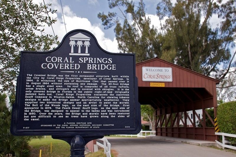
The Covered Bridge was the first permanent structure built within the City by Coral Ridge Properties, developer of Coral Springs, in 1964. It withstood the eye of Hurricane Cleo that passed over it in August 1964 without sustaining any damage. The . . . — — Map (db m100391) HM
Coral Ridge Properties built the City's first real estate office in 1964 at the intersection of Route 441 and Wiles Road, just outside the City limits. This 30-by-20 foot single-room wooden structure displayed maps and plats of subdivisions, none of . . . — — Map (db m47421) HM
African Americans living in South Florida in the early part of the 20th century drove from as far away as Palm Beach and Miami to use Fort Lauderdale’s beaches but met with significant resistance from oceanfront property owners. On May 14, 1946, a . . . — — Map (db m272248) HM
African Americans living in South Florida in the earlier part of the 20th century drove from as far away as Palm Beach and Miami to use Fort Lauderdale’s beaches, but met with significant resistance from oceanfront property owners. On May 14, 1946, . . . — — Map (db m127513) HM
Mount Sinai United Methodist Church 1113 S. Federal Highway (originally called the Dania Methodist Episcopal Church) was organized in January 1906.
The first services were held in the town schoolhouse under the organization influence of Mr. & . . . — — Map (db m146547) HM
The Saint Ruth Missionary Baptist Church was organized in 1908 by the late Charlie Chambers and a few other faithful souls in Modello, Florida. The Church was named Saint Ruth in honor of Brother Charie Chamber's daughter, Ruth. The first place of . . . — — Map (db m146518) HM
Lock No. 1, or Sewell Lock, was designed by world renowned engineers Major S. Sewell and Ben Johnson and built by the Furst-Clark Construction Company of Biltmore. It was part of the Everglades Drainage District and played a vital role in early . . . — — Map (db m100230) HM
This historic structure was the first permanent school in the Everglades and is now Broward County’s oldest existing school building. The Davie School was designed in 1917 by August Geiger (born 1888), who came to Miami in 1905 from New Haven, . . . — — Map (db m41666) HM
Robert "Bob" Rosioli moved to South Florida from Philadelphia, Pennsylvania, with his family in 1956. He started working in the Florida marine industry in 1962, when he took a position sanding boats at the Marine Ways boatyard in Fort Lauderdale. In . . . — — Map (db m216303) HM
Floyd L. and Jane Wray founded Flamingo Gardens, originally Flamingo Groves, in 1927. It first served as a citrus grove, and later became a botanical garden. The Wrays built this frame house in 1933 as a weekend home, and used it for relaxing and . . . — — Map (db m271859) HM
Born in the Bahamas in 1898, Branhilda Richardson Knowles immigrated to the Deerfield Beach area in 1922. Knowles was trained as a midwife, and due to Jim Crow era segregation, helped deliver babies for the African American community in Deerfield . . . — — Map (db m157662) HM
The settlement of Deerfield was founded on the southeast coast of Florida with the coming of Henry Flagler’s Florida East Coast Railroad in 1896. In 1902, two Methodist missionaries began holding religious services for the community. These early . . . — — Map (db m100392) HM
In 1906, Deerfield Beach established Colored School #9 to educate African American children prevented from attending white-only schools in Broward County. A one-room, wooden structure located near NW 1st Avenue, it was destroyed in the Hurricane of . . . — — Map (db m271785) HM
Captain Joshua James embodies the courage and determination of 19th century lifesaving crews. Born in Hull, Massachusetts 1836, James lost his mother to shipwreck when he was just 10 years old. "Ever after," he was said to "scan the sea” in search . . . — — Map (db m212605) HM
During the devastating gale of November 25-26, 1888, Captain Joshua James led Hull's Massachusetts Humane Society volunteer lifesavers in the courageous rescue of 29 men from five ships. The volunteers faced the greatest danger while bringing eight . . . — — Map (db m212606) HM
Naval Air Station Fort Lauderdale (NASFL), a complex of over 200 buildings, was built on the site of Merle Fogg Field in 1942 and served as one of a few specialty schools for training on the TBF/TBM Avenger torpedo bomber. Nineteen-year-old pilot . . . — — Map (db m100393) HM
Founded in 1946 by Colonel Joseph Mackey, Mackey Airlines became (August 5, 1952) the first certificated carrier in Broward authorized to engage in scheduled foreign transportation. Operations began January 2, 1953 between Fort Lauderdale, West . . . — — Map (db m61917) HM
On July 4, 1961, local NAACP president Eula Johnson and black physician Dr. Von D. Mizell began a series of nationally publicized "wade-ins" of Fort Lauderdale beaches. Johnson, Mizell, a third black adult, and four black college students . . . — — Map (db m48852) HM
Bahia Mar is the site of a haulover where Indians took their canoes from New River Sound into the Atlantic Ocean. A Second Seminole War fort named for Major William Lauderdale was built near here in 1838. It was active until the War ended in 1842. . . . — — Map (db m47419) HM
This tablet marks the site of the Third "Fort Lauderdale" named in honor of Maj. Wm. Lauderdale, Cmdr. Tenn. Vol.
Built in 1839 under the command of Captain William B. Davidson during the Second Seminole War
First erected by the Himmarshee . . . — — Map (db m171849) HM
This memorial honors all American veterans who, although separated by generations, shared a common, undeniable goal -- to valiantly protect our country's freedoms.
The memories of these American veterans will continue to live on whenever and . . . — — Map (db m295269) WM
During racial segregation, Fort Lauderdale's African American community was restricted to the northwest quadrant of the city. Recognizing a need in this area, the Christian Pallbearer's Association founded North Woodlawn Cemetery in 1926, most . . . — — Map (db m145503) HM
Many Civil War veterans are buried at Evergreen Cemetery in addition to the founding families of Fort Lauderdale including the Stranahans (who built Stranahan house on SE 6th Avenue), Bryans, Kings, Cromarties (the maiden name of Ivy Julia Stranahan . . . — — Map (db m72809) HM
On this spot, January 31, 1893, Frank Stranahan, the founder of this city, conducted a ferry across New River, established a trading post with the Indians and operated the first U.S. Post Office.
Seven tenths of a mile west of this point . . . — — Map (db m100795) HM
Born at White Springs, Florida, on the banks of the Suwannee River, came to Fort Lauderdale, Florida in 1899 as the town's first school teacher. She married Frank Stranahan in 1900 and lived at the Indian Trading Post on New River, where she . . . — — Map (db m100385) HM
An excellent example of frontier Florida architecture, the Stranahan House was constructed in 1901 for Frank and Ivy Stranahan, two of this area's earliest residents. It sits on the site of Stranahan's Trading Post. Initially the structure was used . . . — — Map (db m100541) HM
During the 1920s Florida Land Boom, the present-day Nurmi Isles subdivision was dredged to create the four finger islands. Bridges providing access to each island were constructed, but no additional development occurred until Victor Nurmi purchased . . . — — Map (db m108909) HM
Honeymooning here in 1948, Frank and Gertrude Denison purchased the shipyard on this site known as Dooley's Boat Basin, renaming it Broward Marine. In 1950, they won the contract to build 11 minesweepers for the Dutch and U.S. navies. The seemingly . . . — — Map (db m216301) HM
This monument marks the site of the William Cooley plantation. Cooley arrived here in 1824 and soon became the leader of the small settlement that grew along the New River.
On January 6, 1836, local Indians attacked Cooley's homestead, killing . . . — — Map (db m127510) HM
Believed to be from the wreck of the British cartel ship "L'Athenaise" sunk Nov 1, 1804 with 179 French prisoners of war.
Found off Barefoot Mailman Hotel, Hillsboro Beach in 1967 by
Dr. Donald King
Bob Jordan
Mel Fisher
Rupert Gates . . . — — Map (db m127814) HM
This building was originally constructed as a post office annex warehouse in 1949. Later it was used by the City of Fort Lauderdale for offices of the City Planning Department. In 1978, the Fort Lauderdale Historical Society converted it into the . . . — — Map (db m172079) HM
In 1907, Edwin T. King, the town's first builder, a boatwright and an early citrus grower, built his third home on the south bank of the New River near what is now US 1. It remained the King family home until 1968. King's daughter Louise and her . . . — — Map (db m127492) HM
Old Fort Lauderdale Village at the intersection of the New River and the Florida East Coast Railway (F.E.C.) incorporates four turn-of-the-20th century historic buildings. These include the 1905 New River Inn, the 1905 Philemon N. Bryan House, the . . . — — Map (db m63880) HM
Philemon and Lucy Bryan's home was built in 1905 by contractor Edwin T. King at the request of their two sons, Reed and Tom. Philemon and Lucy first lived in a wood-frame house that had been converted into the Bryan Hotel. The New River Inn replaced . . . — — Map (db m127489) HM
This replica of the original schoolhouse, which was built by Edwin T. King, was constructed in 1976 as a community Bicentennial Project. The original schoolhouse was located on the corner of South Andrews Avenue and Southwest 5th Street. Ivy . . . — — Map (db m100701) HM
Rivermont is an archaeological site part of what was once a large prehistoric site complex located on the north bank of the New River, within the Sailboat Bend Historic District. Once a thriving Tequesta village and ceremonial complex, this site . . . — — Map (db m250561) HM
Residence of Judge Frederick Bleeker Shippey
Broward County's second appointed Judge servicing from 1920 to 1933. He was most often sought out to perform marriages to notables and celebrities — — Map (db m127509) HM
The prehistoric peoples of Fort Lauderdale, commonly known as the Tequesta, occupied camps as early as 500 BCE in the area now known as Sailboat Bend. By 1800, Seminole Indians and Bahamian and American settlers inhabited lands along New River. In . . . — — Map (db m100394) HM
The West Side Grade School was the second elementary school built in the Fort Lauderdale School District. The school was designed in 1923 by locally prominent architect Morris Peterman, and opened on September 21, 1923. The West Side Grade School . . . — — Map (db m99637) HM
This building is one of only three remaining historical buildings on Brickell Avenue, the first commercial street of Ft. Lauderdale. Constructed as the Bivans Hotel in 1922, this building is the oldest surviving structure in Ft. Lauderdale built as . . . — — Map (db m100383) HM
On this 13-acre site, bounded by Broward Boulevard, South Federal Highway, SE 3rd Avenue, and SE 2nd Street, stood the original Fort Lauderdale High School. The land was donated by Frank and Ivy Strahanan, Fort Lauderdale’s first school teacher. . . . — — Map (db m127762) HM
One of three remaining historical buildings on Brickell Avenue, the first commercial street in the City of Fort Lauderdale, constructed between 1924 and 1926, the building was used primarily as a furniture store (as Pace Furniture then Rhodes . . . — — Map (db m100434) HM
The façade is constructed in the same basic design configuration and from the actual bricks that existed on the west wall of the Oliver Building demolished in 1996. The original building was built in 1912 soon after most of Ft. Lauderdale's business . . . — — Map (db m100416) HM
Coming over from the Bahamas sometime before 1792, Suries and Frankee Lewis and their three sons settled on the banks of the New River and were the first permanent settlers of European descent in what is now Broward County. In 1793, after reports . . . — — Map (db m63656) HM
The Tequesta Indians and their ancestors lived and traveled along the New River for at least 5000 years. The Tequesta were Native Americans that lived in Southeast Florida in an area that extended from Boca Raton to Key West encompassing the . . . — — Map (db m100444) HM
Graduated from Fort Lauderdale High School 1937 and from United States Military Academy at West Point with Honors 1941.
Awarded Posthumously the First Congressional Medal of Honor of World War II by President Franklin D. Roosevelt on January . . . — — Map (db m146548) HM
The Parker Playhouse, built on land provided by the City of Fort Lauderdale in Holiday Park, opened in 1967. Dr. Louis W. Parker (1906-1993), an inventor who contributed to both the television and space industries. funded the project. The almost . . . — — Map (db m257572) HM
As a child growing up in Fort Lauderdale, Diana Nyad was a champion pool swimmer. She swam at nearby beaches and became one of the most renowned ocean swimmers in the world. At age 24, she was the first person to swim north to south across Lake . . . — — Map (db m288013) HM
The Greater Ebenezer Missionary Baptist Church was established in 1909 by Sister Lougenia Johnson and Sister Missouri Wilson conducting Sunday School under a rubber tree. In 1910 Rev. A.T. Taylor, his wife, and Sister Lula Mack joined the group and . . . — — Map (db m100359) HM
"To God Be The Glory For All Of The Great Things He Has Done"
In 1902 a mustard seed was planted in the community, and with God's blessing a group known as the "Pioneers" established the first church, which blossomed the dream into a reality. . . . — — Map (db m100395) HM
St. Anne's Episcopal Church was established in 1914 by Melbourne Knowles, Ansel Saunders and A.L. Wilkins, all hailing from the Islands of the Bahamas. The first church services were held in a wooden building located on the corner of what in now . . . — — Map (db m100397) HM
In 1901, the U.S. Congress approved funding for a light near Hillsboro Point to fill a 90-mile void between the town of Jupiter and the Cape of Florida. Manufactured in Detroit, Michigan and reassembled at the Hillsboro Inlet in 1906. The . . . — — Map (db m172172) HM
This lighthouse is one of five skeletal cast-iron towers built by the Russel Wheel and Foundry Co. in Detroit, Michigan. The optical system was built in 1906 by Barbier Benard et Turren in Paris, France. Following its construction, the lighthouse . . . — — Map (db m127765) HM
Before there were roads in South Florida, U.S. Mail carriers known collectively as "The Barefoot Mailman" risked their lives to deliver the mail. They traversed a 68 mile route - 20 by boat and 48 by foot - along the Atlantic Coast between Palm . . . — — Map (db m127783) HM
Built in 1923 by Bastian Construction for professional offices, the building was occupied by Dentist Arthur Kellner, Hollywood's mayor in the 1930s, and Karlberg Studios Photographer. In the late 1990s to early 2000, the Hollywood Boulevard Theater . . . — — Map (db m99737) HM
The Council Oak Tree Site reflects the Seminole Tribe of Florida's growth over the years and stands as a symbol of strength and stability. The Council Oak Tree was the site of the meetings that led to the creation of the Seminole Tribe of Florida . . . — — Map (db m100134) HM
The Hammerstein House, designed in the Tropical Modern style by Bayard Lukens in 1935, was the home of Vera and Clarence Hammerstein. The interior of the house has beautiful detailed archways, ceilings, and floors which includes the use of . . . — — Map (db m99736) HM
Hollywood-by-the-Sea, unlike most historic towns which grew and evolved over time, was envisioned and designed by one man: Joseph W. Young, Jr. He planned this modern city from the ground up, carefully considering every detail. Young realized . . . — — Map (db m268477) HM
The building was built by J.W. Young in 1925 as the new home for the Hollywood Land and Water Company's publishing business. The Toggery Shop Men's Wear was on the ground floor, east side. In 1934, James Breeding converted the building into a drug . . . — — Map (db m99738) HM
Initially in other locations, Melina Tomich's shop sold children's wear. In 1946, Melina built the shop here at 2010 Hollywood Boulevard branching into ladies' wear, in particular lingerie. Today, Melina's is the oldest continually operated family . . . — — Map (db m99735) HM
The Morse Arcade was built in 1923 by Mr. and Mrs. J.P. Morse, an arcade was an early mall with a variety of shops & offices. In 1927, it was the home of Hollywood's first library. — — Map (db m99790) HM
Prohibition ended in 1933. In the mid-1930s, when gambling was legal on Hollywood Boulevard, Wellons & McGowan held a license for slot machines at this address. Shortly after that, it was acquired by Breeding's for a liquor store. — — Map (db m99788) HM
Parkland has a rich and unique history involving fire engines and trucks.
In 1973, Parkland acquired a large water tank truck. The city had no water hydrants in the Pine Tree Estates area, so the tanker was needed to provide water to extinguish . . . — — Map (db m243750) HM
In the 1970s, Holmberg Road went straight west from State Road 7 along a path that is now Ranch Road in the BBB Ranches.
By the late '70s, Narco Realty wanted to develop the land called Parkland Lakes Planned Unit Development (now known as . . . — — Map (db m244123) HM
Camp Telogia is a throwback to the past and may be one of Broward County's best-kept secrets. The name most likely came from a Native American word, "Telogia," meaning palmetto. Camp Telogia was acquired in 1961 when Broward County sold 10 acres to . . . — — Map (db m244078) HM
In the early 1980s, the eastern part of the City of Parkland (City) along Holmberg Road was known as Country Point. At that time, the Country Place residential community was under development on the north side of Holmberg Road and north of a . . . — — Map (db m244093) HM
Dr. John Louis Holmberg was born in St. Peter, Minnesota on May 15, 1876. He graduated in 1901 from dentistry school at the University of Minnesota. Around 1901, he married Mary Louise Crane. The family moved to Miami in 1908.
Holmberg served . . . — — Map (db m243629) HM
On July 4, 1884 the Statue of Liberty was presented to America by the people of France. The Statue was a gift of international friendship and is one of the most universal symbols of freedom and democracy.
Liberty Park incorporates many of the . . . — — Map (db m247705) HM
Building Liberty Park wasn't just about playground equipment. It was about building a sense of community in Parkland. From conceptualization to the finished product, residents were at the helm, raising funds, gathering materials, and organizing the . . . — — Map (db m244067) HM
Side 1
The Margate Blount Site was known as early as 1940. Parkland Founder Bruce Blount observed what appeared to be a wooden crypt filled with skeletal remains when in 1959 a bulldozer struck the mound and scattered bones. The remains were . . . — — Map (db m249972) HM
The majestic Statue of Liberty towers above Liberty Island at the entrance to New York Harbor in upper New York Bay. In 1884 the people of France gave it to the United States in recognition of the bond of friendship they developed during the . . . — — Map (db m244091) HM
Early residents of the Parkland area have been aware of the Margate Blount site since 1940. In 1959, a bulldozer struck the mound and scattered bones. Since neither Parkland nor Coral Springs existed the site was jointly named for the adjacent . . . — — Map (db m253376) HM
This street, SW 72nd Avenue, was dedicated on
September 1, 2021 to honor Taylor Bishop, 4, who
tragically lost his life from injuries sustained
after a plane crashed into his mother's SUV
near North Perry Airport on March 15, 2021.
Friends and . . . — — Map (db m272175) HM
One of the most historic locations in Pompano Beach, the Hillsboro inlet was given its name by surveyor William de Brahm in the early 1870's. The name honored British aristocrat Lord Wills Hill, the Earl of Hillsborough. It is not clear how the . . . — — Map (db m213478) HM
Bird Sanctuary
This mound was constructed as a place for ceremonial burial by prehistoric Indians about the year 1300 A.D.- It is believed that they were ancestors of the tribe known as the "TEQUESTA INDIANS"
Given to the people of Pompano . . . — — Map (db m128278) HM
Side One:
The Pompano Beach Indian Mound is a prehistoric sand burial mound that was used by the Tequesta tribe and their ancestors for burial of their dead. Located nearby was their associated village and midden dating as far back as AD . . . — — Map (db m100403) HM
The recreation area encompassed by Colony Club Road, during World War II (1941-1945), was the site of the corrals and paddocks for the United States Coast Guard’s Silver Thatch Mounted Beach Patrol. The mounted beach patrol protected the coast from . . . — — Map (db m127514) HM
(Side 1)
The first school for Pompano Beach’s African American students was a two-room wooden building that was destroyed in the 1926 Great Miami hurricane. Classes were held in the Psalters Temple AME Church until a new schoolhouse could . . . — — Map (db m137400) HM
Hundreds of years ago, the Everglades stretched across 3 million acres from Lake Okeechobee to Florida Bay. Today, it is half that size - this makes mitigation efforts essential!
Mitigation Means …
Reducing the force or . . . — — Map (db m271873) HM
The light of freedom still burns brightly in our world today because or the service and sacrifice of America's men and women in uniform.
Our Nation's servicemen and women have fought the forces of tyranny and won victories for liberty, human . . . — — Map (db m271841) WM
In 1910, Miami’s first registered architect, Walter C. DeGarmo, partnered with Franklin C. Bush and John C. Gramling to form the Cocoanut Grove Development Company. In 1911, the company platted the subdivision in the southern part of the town of . . . — — Map (db m228378) HM
(side 1)
A distinctive type of vernacular architecture found in Key West and South Florida is the Bahamian or Conch house. The name "Conch" was attached to Bahamians who worked as wreckers, ship builders, spongers, and merchants. The name . . . — — Map (db m150495) HM
(side 1)
Originally African American residents of Coconut Grove attended integrated religious services at Union Chapel, now known as Plymouth Congregational Church. The African Americans, who were used to a more spirited religious . . . — — Map (db m120630) HM
The Cocoanut Grove Public Utilities Company was established in 1916 by William Matheson and his son Hugh to provide local residents with telephone and water services. A ground level storage tank, filled from wells on the site by two diesel engines, . . . — — Map (db m77925) HM
This library stands as testament to the tenacity of Coconut Grove’s pioneering citizens. Established by the Pine Needles Club, an organization for young girls formed by local teacher Mary Barr Munroe, the first library operated out of a room . . . — — Map (db m150781) HM
(Side 1)
This theater is one of the few structures in downtown Coconut Grove that typifies the flamboyant era of the 1920s. Envisioned by Miami entrepreneurs Irving Thomas and Fin Pierce, The Grove was a luxurious movie theater designed in . . . — — Map (db m150783) HM
This low oolitic limestone building was the office and stable of Dr. Eleanor Galt Simmons (1854 – 1909), Dade County’s first female physician. Simmons, a Bryn Mawr College alumna, graduated from the Women’s Medical College of Philadelphia in 1880. . . . — — Map (db m145501) HM
(Side 1)
Bahamian immigrants played an integral role in the development of Coconut Grove. African-Bahamian immigrant Ebenezer Woodbury Franklin Stirrup was born in 1873, and emigrated from the Bahamas in 1888. Stirrup worked as a . . . — — Map (db m150795) HM
Side 1
In the early 20th century, John Bindley (1846-1921), president of the Pittsburgh Steel Company, was among a wave of wealthy northern industrialists who built winter homes along the shore of Biscayne Bay. In 1917, he purchased this . . . — — Map (db m146091) HM
(Side 1)
In the late 1800s, African-Bahamians migrated to the United States after exhaustion of the islands’ rocky soil. South Florida and the Florida Keys, with similar geography and climate, became attractive destinations. Most Bahamians . . . — — Map (db m150852) HM
(Side 1)
Organized as the Housekeepers Club of Coconut Grove when it was founded in 1891, the Woman’s Club of Coconut Grove is the oldest federated woman’s club in South Florida. Together with other pioneer women, local school teacher Flora . . . — — Map (db m150790) HM
Mariah Brown was born in the Upper Bogue, Eleuthera, Bahamas in 1851 and immigrated to the United States in 1880. Brown lived in Key West with her three daughters and worked as a laundress. By 1889, Brown had moved to Coconut Grove to work in the . . . — — Map (db m150796) HM
Known as the “Air Gateway between the Americas”, the Pan American Seaplane Base and Terminal Building is significant in the history of modern air transportation and is an outstanding example of air terminal design. In 1929, Pan American Airways . . . — — Map (db m150780) HM
The Barnacle is the oldest home in Dade County still standing on its original site. It was built in 1891 by Ralph Middleton Munroe, one of Coconut Grove's most prominent pioneers. He first visited South Florida in 1877 and moved to this area in . . . — — Map (db m77536) HM
(Side 1)
This seaplane hangar was a part of the first permanent United States Coast Guard Air Station in the country. Built in 1932, the hangar served as a crucial center for Coast Guard aviation in Florida. Planes from Dinner Key carried . . . — — Map (db m150778) HM
Chapman Field Park is named for military hero Victor E. Chapman, the first American pilot to give his life in World War I. Chapman was a member of the famed Lafayette Escadrille, an aero squadron composed of brave American flyers who went to France . . . — — Map (db m273354) HM
Tropical Park’s historical significance stems from its location on the grounds of the former Tropical Park Race Track. As part of the Southern Florida circuit with Hialeah Park and Gulfstream Park, the Tropical Park horse racing track held the first . . . — — Map (db m228600) HM
Originally eight feet wide, Le Jeune Road was built by James D. Girtman (1874-1960). In addition to being a road builder, Mr. Girtman was also a successful grocer, fur trader, expert on Seminole culture, and fruit and vegetable grower. In 1902, Mr. . . . — — Map (db m74932) HM
500 entries matched your criteria. The first 100 are listed above. Next 100 ⊳