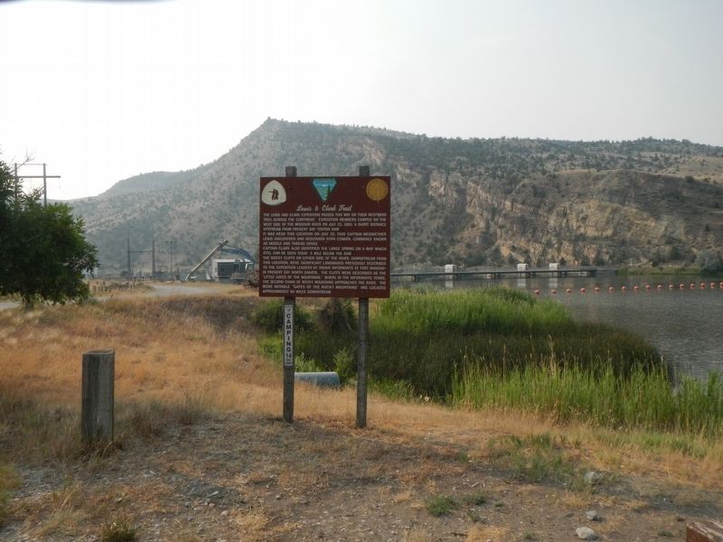
The Lewis and Clark Expedition passed this way on their westward trek across the continent. Expedition members camped on the west side of the Missouri River on July 25, 1805, a short distance upstream from present day Toston Dam.
It was near this . . . — — Map (db m192879) HM
This Plaque Commemorates the Courage and Strength of the Early Pioneers.
Lorentz Homestead
In 1884, William B. Lorentz and his wife Malvina Lorentz moved to this area of the Montana Territory and in 1887 filed a Declaration of . . . — — Map (db m188780) HM
Norwegian immigrant Tom Toston established a ranch and ferry near here in 1871. Strategically located at the junction of the Helena-Gallatin Valley Road and the road to Radersburg, a settlement quickly grew up around Toston’s ranch. Soon the town . . . — — Map (db m188779) HM
Its Beginning
Significant production of gold-rich pyrite ores in the Radersburg District of the Elkhorn Mountains during the 1870s eventually lento the construction of the Toston Smelter in 1885. The Toston Smelter Company - incorporated in . . . — — Map (db m188778) HM
Shortly after the discovery of gold in Confederate Gulch, freighters established a road between Helena and Diamond City. The Missouri River was a barrier to travelers until John Oakes established a ferry in Black Rock Canyon in 1865. A small . . . — — Map (db m141733) HM
"See out at sunrise, the current very strong; passed a remarkable bluff of a crimson coloured east on Starboard intermixed with Stratas of black and brick red slate..."
Imagine canoeing against the Missouri's current, never sure of . . . — — Map (db m192881) HM
J. P. Kearns came to Townsend from Benton, Wisconsin, in 1899. Business-educated and experienced, Kearns astutely recognized the town’s need for a new financial institution and founded the State Bank of Townsend only three months later. The bank was . . . — — Map (db m141732) HM
In 1864, prospectors discovered promising placer gold deposits in Confederate Gulch, named for their political sympathies during the Civil War. This led to a huge gold rush that brought thousands of people to the gulch and the discovery of some of . . . — — Map (db m141735) HM
On December 5, 1875, Masons in Meagher County chartered Valley Lodge No. 21 (A.F. & A.M.) in Centerville, a farming community just north of present-day Townsend. The lodge moved to Townsend in 1884, shortly after the Northern Pacific Railroad . . . — — Map (db m188781) HM
York (ca. 1770-1831) is the only name given for Captain William Clark's slave in the journals of Lewis and Clark (Moulton, 1988).
Lewis and Clark's journals frequently refer to York, a black slave to Captain William Clark. York played an . . . — — Map (db m141726) HM
(Three historical panels are located at this informational kiosk:)(Panel 1:)
Winston - A Town with Dreams of Striking it Rich
Winston History
Welcome to the community of Winston and this area of the . . . — — Map (db m188668) HM
The Hope, Katy and White Elephant mines behind this sign were once part of the most productive mining enterprise in the history of the Basin. The Hope and Katy lodes produced $5,000,000 of ore between 1890 and 1910. On April 20, 1895, the Blast . . . — — Map (db m186124) HM
This is about the center of a rich mining district extending from Butte to Helena. The mountains are spurs of the Continental Divide.
Ghost and active mining camps are to be found in almost every gulch. The ores yield old, silver, copper , lead . . . — — Map (db m186119) HM
For centuries Native Americans have been coming to these pure, flowing hot water springs for rest and healing. Legend tells that they called this area Peace Valley. They agreed to lay down their weapons when they sojourned here, believing that the . . . — — Map (db m186201) HM
Originally this site, now named Boulder Hot Springs, was known only to Nomadic Indians during yearly mountain crossings. The waters bubble out of the mountains just south of here at temperatures ranging from 120 to 182 degrees and are known . . . — — Map (db m186245) HM
In 1888, Jefferson County voters passed a $40,000 bond issue to build a permanent courthouse. Flourishing gold and silver mines and the advent of the railroad meant the county would see its population quadruple between 1870 and 1890, and there . . . — — Map (db m186193) HM
Montana pledged its commitment to children with disabilities in 1887 when Territorial Governor Preston Leslie requested funds for a Montana Deaf and Dumb Asylum. Its title, although shocking by today’s standards, reflects accepted nineteenth-century . . . — — Map (db m186195) HM
The trusses on this structure were salvaged from the "Hubbard" or "Red" Bridge. The original structure was built by the Gillette-Herzog Manufacturing Company in 1899. The company was one of several Minnesota-based bridge construction firms active in . . . — — Map (db m186202) HM
Swiss miner Peter Wys discovered the lucrative silver veins of the Elkhorn Mine that would eventually yield $14 million. After Wys died in 1872, Helena entrepreneur Anton M. Holter and partners developed the Elkhorn Mine. Holter sold out to an . . . — — Map (db m290533) HM
On August 1st, 1805, William Clark celebrated his 35th birthday by shooting a bighorn sheep as he passed through the Jefferson River Canyon.
When the Corps of Discovery explored this area, bighorn sheep were common here. Later in the century . . . — — Map (db m141644) HM
In August 1840, Pierre Jean De Smet, a Catholic missionary of Belgian birth, camped near the mouth of the Boulder River with the Salish Indians and celebrated the holy sacrifice of the Mass. Father De Smet left the Indians soon after to go to St. . . . — — Map (db m128362) HM
Today as you travel in Lewis and Clark Caverns State Park you are likely to see mule deer, signs of elk and perhaps a black bear. This terrain was suitable for wildlife but when Lewis and Clark passed here in 1805 and 1806, these potential food . . . — — Map (db m141648) HM
On August 1, 1805, the Lewis and Clark Expedition camped at a point 200 yards west from this spot on the south bank of the river facing the mouth of the creek which flows into the river from the north. Meriwether Lewis and three others, on a . . . — — Map (db m128371) HM
This is the former site of the Lewis and Clark Caverns Park Entrance Building, a simple A-frame which welcomed visitors to the park for over fifty years.
In 1939, park management began plans to build a greeting center and caretaker residence . . . — — Map (db m141650) HM
In 1868 the first mine was started in the Elkhorns. A.M. Holter, a Virginia City pioneer, started the Elhorn Mine in 1875. by February of 1888 the mine was producing $30,000 worth of ore monthly.
As the mine developed during the 1870's the . . . — — Map (db m290524) HM
The story of the Elkhorn Mountains Volcanics and the Boulder Batholith is the short of how molten magma or melted rock rising up through the crust of the earth just kept coming and coming and coming - from about 81 to about 74 million years ago. . . . — — Map (db m186551) HM
Time was when ox and mule teams used to freight along this route. A five-ton truck doesn't look as picturesque but there hasn't been much change in the language of the drivers. bar
Jerk-line skinners were plumb fluent when addressing their teams. . . . — — Map (db m186274) HM
The Fisk or Northern Overland Expedition camped at the future site of Montana City just east of I-15 in 1862. The outfit, consisting of 125 emigrants, left Minnesota in June, 1862, under the leadership of Capt. James Fisk for the purpose of opening . . . — — Map (db m186275) HM
Between the time dinosaurs went went extinct 65 million years ago, and the beginning of the Ice Age, some 2 million years ago, is a time called the Age of Mammals. During this period of time the western third of Montana experienced a variety of . . . — — Map (db m141642) HM
Authorized by the town council in 1922, the fish pond was designed and built by American Legion commander, Edwin C. Speck. He received $195.40 for labor and materials. The rocks on the center pyramid are all donated local ore samples. A dough boy . . . — — Map (db m193058) HM WM
Newlyweds Lot and Hilda Borden arrived in Whitehall early in 1900, and for the next seventy years, their business contributed to the local economy. At first, Lot ran a saloon and Hilda a cafe. The Bordens built the east portion of the present . . . — — Map (db m193009) HM
Montana was part of Idaho Territory in 1863. In 1864 when
the Idaho Territorial Legislature agreed to a separate
Montana Territory, its members wanted the boundary to
be the Continental Divide. When the separation bill was
proposed in Congress, . . . — — Map (db m91535) HM
Two forges and an interior wood partition seared with the impressions of cattle brands manufactured on site attest to this property’s long history as a blacksmith shop. Canadian immigrant Treffle Bergeron opened (and likely built) the lot’s first . . . — — Map (db m220205) HM
The coldest official temperature ever recorded in the continental United States occurred at a mining camp near here January 20, 1954 when the temperature dropped to 70 degrees below zero. — — Map (db m73525) HM
The Lewis and Clark Expedition passed through this canyon of "nearly perpendicular rocks" during its journey up the Missouri in July 1805. Although the men grumbled about mosquitoes and prickly pear cactus, the Corp of Discovery was clearly . . . — — Map (db m141859) HM
"To pass across the Traveler's Rest Creek to the Missouri at the Mouth of the Dearbourn's River is 400 miles nearer that the route we Came..." Captain William Clark, Written at Fort Clatsop
As the Corps of Discovery wintered with the . . . — — Map (db m141921) HM
"previous to our departure saw a large herd of the Bighorned anamals on the immencely high and nearly perpendicular clift opposite to us; on the face of this clift they walked about and bounded from rock to rock with apparent unconcern where it . . . — — Map (db m141922) HM
"...from the singular appearance of this place I called it the gates of rocky mountains." Captain Meriwether Lewis, Friday, July 19, 1805
After the difficult portage around the five falls of the Missouri River, the Corps of Discovery . . . — — Map (db m141856) HM
" at the distance of 2 1/2 miles we passed the entrance of a considerable river on the Stard. side; about 80 yds. wide being nearly as wide as the Missouri at that place. it's current is rapid and water extremely transparent; the bed is formed of . . . — — Map (db m141857) HM
Wherever you are in Montana, you stand in the pathway of Lewis and Clark. Their 1804-1806 expedition was a grand adventure to investigate the people and resources of the newly acquired Louisiana Purchase and to seek a navigable passage across the . . . — — Map (db m141860) HM
The Missouri River Bridge, just southwest of here, is dedicated to the memory of Captain Michael John MacKinnon, who gave his life in defense of his county. A native of Helena, MacKinnon graduated from West Point in 1997 and was commissioned a . . . — — Map (db m141858) HM WM
"in the evening we passed a large creek about 30 yds wide which disembogues on the Stard. side; it discharges a bold current of water it's banks low and bed frormed (sic) of stones altogether; this stream we called Ordway's creek after Sergt. . . . — — Map (db m245681) HM
...we passed the entrance of a considerable river on the Stard side about 80 yds wide being nearly as wide as the Missouri at that place... This handsome bold and clear stream we named in honour of Secretary of war calling it Dearborn's . . . — — Map (db m141923) HM
"..to take a small party & to proceed on up the river, some distance before the canoes, in order to discover them (Indians), should they be on the river before the daily discharge of our guns, which was necessary in procuring substance, . . . — — Map (db m245679) HM
The Main Street and J.F. Kennedy Parks are for your enjoyment with tables, benches, rest rooms, swimming pool and playground equipment.
The American Smelting & Refining Company produced lead bullion from ores shipped in from Idaho, Montana, . . . — — Map (db m127499) HM
During the summer of 1864 a wagon train from Iowa heading west for the Oregon country stopped near this site to rest and repair their wagon before crossing the Rocky Mountains.
Among these pioneers were Jonathan and Elmira Manlove and their two . . . — — Map (db m141793) HM
Named for the daughter of a local rancher, Augusta was established on Fred Walrath's homestead in 1884. It prospered as a trade center for a vast cattle and sheep ranching area. By the 1890s, Augusta's main street included dwellings, hotels, . . . — — Map (db m157405) HM
The second cabin to your right is "The Pioneer Cabin". This cabin was built of hand-hewn logs in 1864, and is one the oldest cabins in Montana. It exemplifies a typical miner's residence of the gold rush era.
"The Pioneer Cabin" has been . . . — — Map (db m187374) HM
On this site was located Helena's first Masonic Hall, owned by the Helena Lodges. Erected by Hartwell, Jurgens & Co., the second floor of the building was first used for Masonic meetings in December, 1866. The Fifth Annual Communication of the Grand . . . — — Map (db m188521) HM
In September 1887, the Helena Weekly Herald noted “nine first-class brick residences” under construction on South Rodney Street. Among them were three nearly identical duplexes, called Galen Estates after one of the development’s principal . . . — — Map (db m188209) HM
A small L-shaped dwelling with a full-length front porch stood on this lot by 1875 according to an early bird’s-eye map of Helena. German Catholic rancher Herman Rosenbaum and his wife Mary purchased the house in 1879. The neighborhood was perfect . . . — — Map (db m188210) HM
An early one-story wooden dwelling stood here by 1884, replaced by 1888 with a two-story brick residence, set slightly back from the street. The home soon found itself ensconced in a busy commercial district. Neighbors included saloons, grocery . . . — — Map (db m188329) HM
Jacob T. Gove, a miner and assayer, developed the Bonanza Chief gold mine near Montana City in 1883, netting over $9,000 from three carloads of ore. With his small fortune, he opened an assay office, built the house next door at 229 for his family, . . . — — Map (db m188180) HM
Mining required back breaking labor and, after the easy pickings were gone, substantial capital. How did prospectors decide whether to continue working particular veins? They brought ore samples from their claims to an assay office, where they were . . . — — Map (db m188179) HM
Two distinct front porches attest to the separate histories of these two nineteenth-century homes, combined into one in the late twentieth century. The older of the two at 490 West Main was built between 1865 and 1875. Segmentally arched windows and . . . — — Map (db m187480) HM
Senator T. C. Power met A. C. Johnson in Chicago and, taking a liking to the young man, offered him a job out west. The nineteen-year-old came to work as chief clerk at Power’s Fort Benton Mercantile in 1879. Power and Johnson became friends and . . . — — Map (db m187736) HM
George and Anna Pascoe, both natives of England, moved to Helena from Butte in 1908. George died soon after the couple purchased this home in 1911. Although he was not long a resident of Helena, George, “with a cheery smile and a good word for . . . — — Map (db m187740) HM
The fanciful façade of this nineteenth-century showcase was intended to convey a powerful message. Completed in 1889 for the insurance company of Samuel J. Jones at a cost of $40,000, the vivid imagery is an advertisement, showing how insurance . . . — — Map (db m186556) HM
Charles Hendrie opened Helena’s first iron foundry on this site before 1868. The property’s third owner, Benjamen K. Tatem, built this two-story residence circa 1875. Wide eaves, low hipped roof, and tall arched windows proclaim Italianate . . . — — Map (db m187475) HM
An octagonal tower, decorative brickwork, one-story open porch, and hipped roof identify this appealing Queen Anne style residence built circa 1883. That year launched a period of neighborhood expansion and prosperity, kindled when the tracks of the . . . — — Map (db m188086) HM
Gold discoveries at Last Chance Gulch in 1864 brought a diverse population to the booming settlement of Helena. In 1870, Lewis and Clark County Commissioners established this ten-acre cemetery to serve the growing population. The first interments . . . — — Map (db m141794) HM
Legend has it that architect James F. Stranahan built this striking residence of locally quarried blue granite for his bride, Leona, in 1889. Stranahan died, however, leaving the home unfinished. Records do show that Leona briefly owned the . . . — — Map (db m188520) HM
Established by the state legislature in 1901, Montana’s Board of Health was originally housed in two small offices in the capitol building. As the state devoted more attention to public health during the Progressive Era, the Board’s responsibilities . . . — — Map (db m186778) HM
Historic maps and early directories reveal that this splendid business block was constructed circa 1890. Morris Auerbach, in business with Israel L. Israel and Adolph Marks during the 1890s, was the original occupant. Their Boston Clothing Company . . . — — Map (db m186610) HM
Newlyweds Isaac Boyer and Carrie Feldberg Boyer moved to their new home within a year of their 1907 marriage. The refined, hipped-roof residence may well have been built to order. The two-story house features popular Colonial Revival style details, . . . — — Map (db m187660) HM
The exotic Broadwater Resort is a good example of the tastes of gold rich Helena in the 1890's. The naturally heated "natatorium", Byzantine in design was billed as the "largest
bath in the world under one cover." The pool was 100 feet wide, over . . . — — Map (db m186675) HM
The home of territorial Governor Benjamin Potts sat on this property from the 1870s until this grand residence was built for prominent Helenans Charles B. and Mable Power circa 1907. Power’s father was merchant prince and early U.S. Senator T. C. . . . — — Map (db m188332) HM
Prominent Helena investor and real estate developer Charles W. Cannon commissioned the firm of Wallace and Thornborgh to construct this building for $10,000. Completed in 1890, the building reflects expansion and urbanization in the downtown area . . . — — Map (db m187145) HM
Most of Helena’s earliest commercial buildings fell victim to the fires that plagued the gulch. This simple 1860s commercial building, originally a single story of stone construction, was a notable exception, surviving a disastrous conflagration in . . . — — Map (db m186670) HM
According to reminiscences of the Butts family, builders of the Pioneer Cabin next door, two cabins stood on this lot in 1865. William Davenport likely built one for his family and the William H. Parkinsons occupied the other. Sallie Davenport, . . . — — Map (db m187373) HM
Helena entrepreneur William Chessman built these exemplary Queen Anne style townhouse apartments in 1891 while in residence across Sixth Avenue at 304 North Ewing. Gables, bays, and a rounded turret handsomely demonstrate the architectural . . . — — Map (db m188458) HM
William C. Child came to Montana from Iowa in 1870 as an agent for the Wells Fargo Express Company. President U. S. Grant soon appointed him territorial land office registrar and Child made a small fortune in mining investments. This two-story barn, . . . — — Map (db m188331) HM
John B. Sanford was born on a farm in Maine to Quaker parents. His father, then retired, had been captain of a whaling vessel. Sanford came to Montana in 1864 at the age of 29. On the journey west he formed a partnership with 24-year old Christmas . . . — — Map (db m187589) HM
Following World War II, Montana’s growing state agencies desperately needed all types of space. Consequently, in 1946 the Montana State Postwar Planning and Construction Commission recommended building a laboratory where all testing for state . . . — — Map (db m186915) HM
The Colorado Building is a rich illustration of Helena’s commercial blossoming during the early twentieth century. The Mountain States Telephone and Telegraph Company built the structure in 1922, thereby completing this block in the town’s more . . . — — Map (db m187243) HM
This reproduction of the Liberty Bell was presented to the people of Montana by direction of The Honorable John W. Snyder Secretary of the Treasury
As the inspirational symbol of the United States Savings Bonds Independence . . . — — Map (db m128486) HM
On this placer mining claim, gold was discovered on July 14, 1864 by John Cowand and John Crab of Georgia, Bob Stanley of London, England and D.J. Miller of California known as "The Georgians" who were returning from an unsuccessful prospecting . . . — — Map (db m187078) HM
Before the discovery of cold this valley knew only the Indian or the occasional trapper; however by 1867 nearly 7,000 people had poured into the gulch, Last Chance Mining Camp, became Helena, and a new city was born.
Helena truly became a . . . — — Map (db m186485) HM
Reputedly the first two-story building on Main Street and one of Helena’s few remaining structures dating to the 1860s, this stone building originally housed offices and furnished lodgings. Miner and prominent merchant E. M. Dunphy purchased the . . . — — Map (db m186607) HM
Many of Helena's significant landmarks, like the old Land Office, were destroyed by the devastating Earthquakes of 1935, The first shock occured (sic) on the evening of Oct. 3, and for a period of weeks over 2,000 tremors, some violent, did millions . . . — — Map (db m187412) HM
Locally quarried blue-gray granite complements the shingled upper stories in this commanding nineteenth-century home. Both this residence and the one next door are stellar examples of the eclectic Shingle style. The wide porch and asymmetry are . . . — — Map (db m187674) HM
Elisha Poad arrived in Helena in 1867 by way of mining camps in California and Nevada. Poad was a native of Cornwall, England, an area with over two thousand years of mining history. Attracted to Helena’s placer mines, he was later associated with . . . — — Map (db m187478) HM
Lydia Jane English was recently widowed when she and her family moved into this substantial Italianate style residence, built in 1888. Her husband, miner Harvey W. English, was a prominent Helena pioneer who served in the territorial legislature, as . . . — — Map (db m188181) HM
Montana’s leading architectural firm of Link and Haire designed this attractive building for Charles George Eybel in 1922. Stuccoed walls and a raftered cornice along the roofline, reminiscent of the Spanish Colonial Style, combine with a smooth . . . — — Map (db m187136) HM
A probate judge deeded brothers Anton and Martin Holter this property in 1872. The prominent and wealthy Holters operated milling, hardware, real estate, and construction companies. The Holters set up a lumber yard here, which they operated until . . . — — Map (db m187142) HM
Emphasizing balance, symmetry, and restraint, the Renaissance Revival style organizes large buildings into horizontal layers, with each floor becoming increasingly more refined. Designed by James Knox Taylor, the Federal Building achieves this . . . — — Map (db m187314) HM
The Helena branch of the Federal Reserve Bank opened in 1921, the result of lobbying by Norman B. Holter and other farsighted local businessmen. It distinguished Helena as the smallest town in the country to host such a bank. When the 1935 . . . — — Map (db m187311) HM
Entrepreneur T. H. Kleinschmidt was the original owner of this early Italianate style dwelling, built as investment property circa 1884. Kleinschmidt, three times elected mayor of Helena, had diverse local business interests including utilities, . . . — — Map (db m188237) HM
The welfare of the community depended upon this prominent landmark, strategically placed atop the town’s most prominent hill. Fire was the grim reaper that stalked all western mining camps, and Last Chance Gulch was no exception. Hastily built log . . . — — Map (db m188517) HM
This magnificent structure was the second home of Montana Territory’s first bank, chartered in 1866. Combining Romanesque, French Second Empire, and popular Victorian-period stylistic elements, the talented St. Paul firm of Hodgson, Wallingford and . . . — — Map (db m186486) HM
Outstanding architecture and a long history of community service make this stunning landmark much beloved. It is the only known example of prominent architect C. S. Haire’s work in the Richardsonian Romanesque style. Magnificent round arches, a . . . — — Map (db m187312) HM
Rodney Street was prime residential real estate when developer Richard Lockey sold this lot to Francis Pope in 1872. Pope, one of Helena’s first druggists, built a modest home on the property. He and his wife Hannah were prominent in the community . . . — — Map (db m188376) HM
In commemoration of the intrepid explorers, comprising the Lewis and Clark Expedition who discovered this canyon and encamped here July 19-1805 on their westward voyage of trans-continental exploration enroute up the Missouri River bound for the . . . — — Map (db m148173) HM
George and Esther Grossberg built this Craftsman style bungalow in the early 1920s. The mix of multi-colored brick and stucco blends beautifully into the surrounding landscape. Tucked between two Victorian-era homes, this charming 1920s residence . . . — — Map (db m187738) HM
The steamboat Alone brought Stephen Gilpatrick to Montana on the cusp of the 1863 gold rush to Alder Gulch. When mining proved a disappointment, Gilpatrick moved on to Last Chance where he and a partner established the camp’s first stationery store. . . . — — Map (db m187662) HM
On July 16, 1928, a devastating fire swept between the Granite and Gold Blocks (note inscription, second story center). The structure was rebuilt by then-owner Charles Benton Power and was the last major downtown commercial building constructed by . . . — — Map (db m186483) HM
This building is an excellent example of transitional Western Commercial architecture before the advent of more ornate styles. The simple, narrow plan enhanced by decorative windows is typical of the 1870s and early 1880s. A pressed metal cornice . . . — — Map (db m186482) HM
Territorial Governor Preston Leslie was a resident of this early Helena home, constructed in the late 1870s. Originally built in the Gothic Revival style popular during Helena’s townsite period, later remodeling added classical details. The two . . . — — Map (db m188330) HM
Meriwether Lewis’s Masonic apron and an O. C. Seltzer mural depicting the first Masonic meeting in Montana are among the treasures displayed in “the home of Montana Masonry.” A dynamic political and social force since early territorial days, the . . . — — Map (db m187310) HM
Lime manufacture was an essential industry for building in brick and stone in the nineteenth century. The Grizzly Gulch outcrops and the kilns below them supplied the entire region with lime of the highest quality. Joseph O’Neill built the first of . . . — — Map (db m187580) HM
209 entries matched your criteria. The first 100 are listed above. Next 100 ⊳