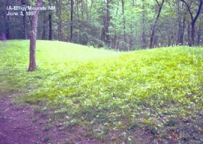
In 1766, English and French Canadian traders wintered near this site. They must have puzzled over these strange earthen shapes-or others even nearer their cabin. The traders could not have known that the humble grave markers were vestiges of a . . . — — Map (db m61987) HM
This building was completed in 1861 by the firm of Hale, Jenkins and Pratt at a cost of $13,655. The 40-acre townsite, including the place where the building stands, was donated by the Shattuck Family. The Allamakee County Board of Supervisors . . . — — Map (db m69527) HM
The Norwegian-American Gjefle log house was built in 1870, and an addition in 1886, in Center Township. It was moved to this site in 1990. — — Map (db m272713) HM
The Allamakee County Freedom Rock The Allamakee County Freedom Rock project was started in 2016 with an application submitted to the Freedom Rock artist, Ray "Bubba" Sorensen to have Allamakee County placed on his waiting list. . . . — — Map (db m232607) HM WM
Dedicated June 13, 1954
In memory of deceased members of Post 27
Memorials for
Cyrill Matt and Arthur Meyer
have made this park possible — — Map (db m202889) WM
The valley of the Mississippi River is one of the most distinctive landscape features of the central United States. Set in a geologic framework of ancient sea floors and glacial flood waters, this rock-lined corridor hosts interesting . . . — — Map (db m202873) HM
This rock marks the beginning of the Old Military Trail first used in the summer of 1840 by troops from Fort Crawford in Wisconsin when building Fort Atkinson in Iowa. It served as a highway for the movement of troops and supplies from Fort Crawford . . . — — Map (db m44190) HM
Cave History
Workers for the Hagensieck brewery created these cave openings around 1867 using picks, shovels and blasting powder. They used the caves to store ice and beer until the brewery closed in 1888. Hundreds of bats used the caves . . . — — Map (db m46742) HM
John Froelich invented the very first successful gasoline powered tractor able to proplel itself backward and forward, in 1892, right here in this village named after the Froelich family. The blacksmith, William Mann, assisted with the creation of . . . — — Map (db m203106) HM
In this village, John Froelich built the first gasoline tractor that propelled itself backward as well as forward. Far-reaching in its effect on modern agricultural history. It moved out of this village and into the world in 1892.
Later that . . . — — Map (db m202935) HM
McGregor
"Royal is my race," was the motto of Clan MacGregor of which McGregor's founder, Alexander MacGregor, was a descendant. It was 1837 when Alexander began a ferry boat operation on "MacGregor's Landing" that became a thriving town of . . . — — Map (db m44758) HM
Across this impressive gorge of the Mississippi River is the mouth of the Wisconsin River. The steeply notched valleys of both rivers are carved into sedimentary bedrock which underlies the level, plateau-like uplands and forms the abrupt, . . . — — Map (db m46138) HM
Across the Mississippi is the mouth of the Wisconsin River. This is the point where on June 17, 1673 Pere Marquette and Louis Joliet, in two small canoes entered the mighty Mississippi. They were the first white men to discover the Upper Mississippi . . . — — Map (db m44797) HM
The original Froelich Train Depot had been a large building located just to the north of the present location of our current depot. It was located on the west side of the old highway 18 & 52. In 1872, the railroad came through what became known . . . — — Map (db m203108) HM
This store was built in 1891 by Edwin Froelich, after the previous general store burned down that had been located where the Frolelich Monument is currently located. It was called the Iron Clad Store for the exterior was covered with fire-proof . . . — — Map (db m203105) HM
Erected in 1902 in memory of the Soldiers and Sailors of the Civil War 1861-1865 Abraham LincolnThe statue of Abraham Lincoln along with the four bronze plaques, which are unique, were sculptured by George Edwin Bissell and commissioned by . . . — — Map (db m162102) HM WM
Fayette County Historical Center has been placed on the National Register of Historical Places by the United States Department of the Interior as the Maple View Sanitarium Built 1903 — — Map (db m162152) HM
How 101-A Got to Cresco
The 101A is a Model FP 7 diesel electric locomotive built by General Motors in La Grange, Illinois in 1951. It is the first such model ever sold to the Milwaukee Road rail line and was put into service in December . . . — — Map (db m141975) HM
The cabin was built in 1854 and was lived in continuously through 1964. The interior contains two rooms: a kitchen on the ground floor and a bedroom above. It was constructed of hand hewn logs, dovetailed and every log marked near the end with . . . — — Map (db m141974) HM
The seeds for this tree were flown abroad the
US Space Shuttle Atlantis, December 2-8, 1988
by Lt. Col. Jerry L. Ross, USAF.
This tree was presented to the City of Cresco
on July 27, 1990, by Maurice Kramer,
Notre Dame High School . . . — — Map (db m141973) HM
Magnetic mine of the German Navy
was brought to Cresco through the
efforts of George Hamilton M/M
who served aboard an American mine
sweeper.
Memorial Dedicated to Cresco's five
admirals:
Frank Lowry
Arthur Moen
. . . — — Map (db m142012) WM
Winneshiek County's Freedom Rock is a part of the Freedom Rock Tour created by the Artist, Ray "Bubba" Sorensen II. In creating the Freedom Rock, Sorensen's aim is to "boost tourism and spread the message of thanking our Veterans while providing a . . . — — Map (db m232996) HM WM
On June 7, 1848, Hamilton Campbell, with his wife and two year old son, arrived at this site, and so became Winneseik County’s first white settler. Campbell travelled by oxen team and covered wagon over the Old Military Trail road to arrive at the . . . — — Map (db m203148) HM
Billed in the Decorah Public Opinion headline of the time as the “biggest day in the history of this county,” thousands of residents of Decorah and Winneshiek County gathered on September 18, 1917 to send off the first contingent of World War I . . . — — Map (db m235988) HM
Overview Many immigrants found community in churches where people spoke their language and held familiar beliefs. Women played very important roles in building community in Norwegian Lutheran churches, even though they were not allowed to vote . . . — — Map (db m236298) HM
Overview Mikkel and Hage Sennes emigrated from Norway with a variety of skills that helped them eventually thrive in America. They also learned new skills once they settled in the U.S. They built this blacksmith shop on their farm in Minnesota . . . — — Map (db m236609) HM
Overview At Vesterheim Heritage Park, the landscape is a sponge for cleaning and absorbing stormwater. The park uses permeable paving, native plantings, and soil restoration to release water slowly into the ground and manage runoff and help . . . — — Map (db m236674) HM
The land on which you are standing has been inhabited by Indigenous people since time immemorial. The most recent Indigenous Tribe to live here was the Ho-Chunk (Ho-chungra, Winnebago) Nation. The ancestral lands of the Ho-Chunk consists of ten . . . — — Map (db m235998) HM
The Millrace: Harnessing Decorah’s Water Power Demosthenes, Greek statesman and orator of ancient Athens observed: "Small opportunities are often the beginning of great enterprises." During an 1848 scouting trip to appraise the . . . — — Map (db m239880) HM
One of the First The limestone building across the street from where you are standing is one of the oldest structures in Decorah. Built in 1855 by one of Decorah's first settlers, William Painter, it has served as a home, bakery, . . . — — Map (db m239899) HM
The Tremont House The northwest corner lot across the street at W. Water and N. Mill Streets has a history dating back to 1856 when Englishman Eli George bought the lot and the Tremont House, a hotel, was built the next year. . . . — — Map (db m240000) HM
“All Things to All People” The mercantile has a long history in Decorah. The first mercantile, the Pioneer Store, opened in the Days’ smokehouse shortly after the Days and the Painters founded Decorah in 1849 and William Painter . . . — — Map (db m240300) HM
Connecting to the Outside World The longed-for arrival of the railroad in Decorah on September 1, 1869 was cause for much celebration with speeches and opportunities for short excursion trips to Conover as part of the festivities. . . . — — Map (db m241100) HM
“The Fire Fiend” Fires have been a hazard since Decorah's early days. Even before an organized fire department existed, Decorah citizens banded together to fight fires threatening buildings and lives. One of the first recorded fires . . . — — Map (db m241300) HM
The Agricultural Short Course of 1912 The first Winneshiek County Agricultural Short Course was held from December 2nd to December 7th in 1912. Advertised in all three Decorah newspapers of the time, it was “an opportunity for the . . . — — Map (db m241400) HM
A Street in Transition The face of Water Street has changed over the years. Beginning with the arrival of settlers in 1849, houses and small businesses sprang up in what is now the Water Street business district. The photo above . . . — — Map (db m241508) HM
The Agricultural Short Course of 1913 After its introduction in December of 1912, the Agricultural Short Course paid a second visit to Decorah from December 8th to the 13th in 1913. (See Sign #15 on the historic trail for information . . . — — Map (db m241641) HM
Decorah Time Lapse: North Side Robert Frost observed, “In three words I can sum up everything I've learned about life: it goes on.” If a time lapse film of this block had been taken, it would reveal how life has “gone on” — changes . . . — — Map (db m241700) HM
Time and the River The presence of water has always played an important part in Decorah's history. The Winnebago and the Oneota before them fished the river, hunted mussels in its depths, and made their dwellings beside it. The . . . — — Map (db m241900) HM
The Pioneer Store The first store in Decorah was located on the corner of Water and Washington Streets just west of where you are now standing. Built in 1851, this frame structure was operated by Aaron Newell and Morris B. Derrick. . . . — — Map (db m242100) HM
The Founding of Luther College Luther College opened in September 1861 in a vacant parsonage at Halfway Creek, Wisconsin, near La Crosse, with 11 students. The Norwegian Synod, the governing body of the Norwegian Lutheran . . . — — Map (db m242101) HM
Broadway Beginnings
Many of the first homes in Decorah were built near the river where the business district now stands and along the roads leading into town. As Decorah grew, those who could afford to do so built farther away from the river . . . — — Map (db m242200) HM
Post War Affluence The Italian Villa home before you was built by dry goods merchant Dighton B. Ellsworth and wife Amanda in 1867. It was part of a building boom in the neighborhood and one of two Italianates built on adjacent corner . . . — — Map (db m242300) HM
The Courthouse Square Winneshiek County's courthouse square is typical of others found throughout the Midwest. Churches, businesses, the public library and homes ring the perimeter. But change has been a constant as the years have . . . — — Map (db m242600) HM
Overview New immigrants often moved to existing ethnic communities where faith, food, and culture were familiar. Sometimes, these new immigrants would need to navigate shared living space and class differences with strangers along with living . . . — — Map (db m236297) HM
Overview Hans and Anna Haugan were in their fifties when they immigrated to America. Not everyone who immigrated to America stayed. By some estimates, nearly one in five Norwegian immigrants returned home. Some left because they earned enough . . . — — Map (db m236300) HM
The Locust School was built in 1854
from rock quarried on the Ruffridge
farm. The school was in use every year
from 1854 to 1960, or 106 years, an Iowa
record for continuous service in the
same building and location. Several
church groups . . . — — Map (db m296619) HM
Overview Nineteenth century Norwegian farmers grew food for their families instead of for income. Many farms in Norway used small water-powered mills to grind grain, press apples and process cloth. These mills were usually only big enough to . . . — — Map (db m236295) HM
Overview Northeast Iowa was home to many different Native American groups that utilized the natural resources of this area for thousands of years. After Native Americans were forced out of the region by the U.S. government, European settlers . . . — — Map (db m236400) HM
With the faith and courage of their forefathers who made possible the freedom of these United States The Boy Scouts of America dedicate this copy of the Statue of Liberty as a pledge of everlasting fidelity and loyalty The Crusade to . . . — — Map (db m235957) HM
Overview In the mid-19th century, a group of Norwegian immigrants who followed the state church in Norway wanted to create a system of schools associated with the church. Congregation members wanted to send their children to public schools to . . . — — Map (db m236299) HM
Overview Vesterheim was the first institution in the United States to collect and preserve buildings by moving them to a museum setting. The Eriksen-Hansen Stabbur protected grain and meat from pests and moisture by elevating them off the . . . — — Map (db m236399) HM
Overview Native Americans lived in northeast Iowa for thousands of years before being forced off their land by the U.S. government to make room for non-native settlers. Colonizers arrived in this area in 1848 and came from numerous countries in . . . — — Map (db m236608) HM
Overview Many buildings on farms in Norway were designed to serve one purpose. This building was probably used to dry grain for brewing beer. While many Norwegians and Norwegian Americans brewed their own beer, others fought for temperance. . . . — — Map (db m236672) HM
Timber Framing in America and Norway There are many ways to build a house or structure. You can stack logs horizontally to form walls, a system that you can see throughout Heritage Park. You can use narrow pieces of sawn lumber in preset . . . — — Map (db m236677) HM
To Build, or Not to Build Controversy surrounded the construction of both the 1857 and the 1904 Winneshiek County courthouses. When local residents proposed building the first courthouse in the 1850s, another faction maintained it wasn't . . . — — Map (db m235961) HM
Overview Norway's population nearly tripled during the 19th century. This increase, combined with restrictive inheritance laws and lack of farmable land, made it extremely difficult to escape rural poverty. Most Norwegian immigrants were from . . . — — Map (db m236296) HM
Look up to see sails. Look down and around you to see the outline of a small ship. Imagine what it would have been like to immigrate to the United States on a sailing ship in the 1800s. The journey may take 6 to 14 weeks. Why are you leaving your . . . — — Map (db m236682) HM
Vesterheim explores the diversity of American immigration through the lens of the Norwegian-American experience and showcases the best in historic and contemporary folk arts in the Norwegian tradition.
Overview The Homestead Act of 1862 made government land taken from Native Americans available for free if it was used for five years. This law allowed millions of European immigrants to settle in the prairies and woodlands of the central . . . — — Map (db m236673) HM
Winneshiek County Jail The jail was originally housed in the first courthouse built in 1857 and located in the basement on the west side of the courthouse. When additional courthouse space was needed, the building you see in the southeast . . . — — Map (db m235993) HM
Fort Atkinson was established in 1840 to monitor the Ho-Chunk (Winnebago) Nation who had been forced to move from their traditional homeland in Wisconsin to the Neutral Ground in northeastern Iowa. The fort's founder, Brigadier General Henry . . . — — Map (db m173841) HM
On the east side of the parade ground was another Officers' Quarters. This was a two-story stone building with gardens and three privies behind it. The commanding officer, Captain C. V. Sumner, had his quarters in the north end of this building. . . . — — Map (db m173851) HM
Fort Atkinson was founded in 1840 as a temporary post to keep the Winnebago (Ho-Chunk) Indians west of the Mississippi River on the land known as the Neutral Ground after their removal from Wisconsin. The Neutral Ground was intended for exclusive . . . — — Map (db m90570) HM
A small frame Guard House stood west of the North Barracks. It had two rooms, one for the guard on duty and one for the prisoners. A 75-pound iron grate separated the two rooms. The Guard House was most often used to hold soldiers who were being . . . — — Map (db m173846) HM
To the right of the main gate is a two-story limestone building, one of the two barracks for enlisted men. The eastern portion of the building served as a hospital. The first floor had mess rooms for eating, a kitchen, and a commandant's office. The . . . — — Map (db m173843) HM
The sturdy structure in the southeast corner of the fort was used to store gun powder and ammunition. These materials were very dangerous so the building has double walls and a vaulted stone roof which were designed to contain an explosion in case . . . — — Map (db m173853) HM
On the outside of the stockade near the southeast corner of the fort, a path ran down to the bottom of the bluff. Here two small log buildings were built into the side of the river bank. One was used to store ice cut from the river in the winter and . . . — — Map (db m173852) HM
The south enlisted men's barracks was a two-story log structure with raised stone platforms in the center of the foundations to help support the wooden floors. This building also served as a schoolroom for the officers' children and as a church on . . . — — Map (db m173850) HM
The fort is laid out in a rectangular shape with the four main barracks arranged around a central parade ground. At 11 feet 9 inches high, the stockade surrounds the main buildings. The pickets, made mostly of oak and some linwood and bass, were . . . — — Map (db m173855) HM
Supply and Demand
The Sutler's Store was not government property. It was build and owned by H. M. Rice. Here, soldiers could purchase miscellaneous personal items such as clay pipes, tobacco, and combs. To haul all his goods, the sutler . . . — — Map (db m173847) HM
Although no battles were ever fought at Fort Atkinson, it was carefully planned and built to withstand an attack. Two block houses (southwest and northeast corners) which held the fort's four cannons projected out beyond the southwest and northeast . . . — — Map (db m173849) HM
One of the oldest Society of Friends Congregations in Iowa organized here in 1855. First Meeting House built in 1856. Frame church erected on this site in 1879; destroyed by fire Oct. 22, 1904. Present church built in 1905. First Winneshiek County . . . — — Map (db m235046) HM
On this site stood two church buildings of the Lincoln Lutheran Congregation 1873-1914 1914-1968 The first building was removed to make way for the second. The second was destroyed by fire on June 9, 1968. The congregation merged with the Ridgeway . . . — — Map (db m272567) HM
In commemoration of the visit of Antonín Dvořák renowned composer, to Spillville in 1893, this tablet is erected by his friends and The Iowa Conservation Association 1925. — — Map (db m239167) HM
United States Army Retired July 31, 1969 Native son of Spillville, IA. Born Aug, 17, 1910, son of Carl R. and Louise Fisher Haug. Early education — Spillville, Decorah, U of I, US Military Academy 1935 graduate. Married Carolyn Meyers, . . . — — Map (db m239184) HM
You are standing on the site of Big Stone Mills. During pioneer times, a working mill made an important contribution to a town's ability to survive. In 1856, two teenagers from Spillville were sent to a mill in Waucoma to pick up a supply of . . . — — Map (db m239000) HM