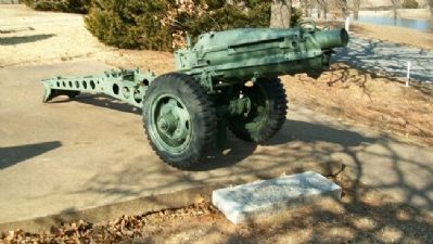
This 75mm Howitzer is a memorial to
1st Lt. Robert F. Trigalet, U.S.M.C.
The first Marine from Bristow who gave
his life for God and Country in the
Vietnam Conflict. (Died May 2, 1969) — — Map (db m41919) HM
This 3 Inch 50mm Deck Gun is
dedicated to Clifford Murl Satterfield
Aviation [Machinist's] Mate First Class
U.S. Navy, Killed in Action
off the U.S.S. Enterprise. South Pacific
April 29, 1944 — — Map (db m41922) HM
In 1895 a concrete walk was installed by the City of Bristow across Main Street at 7th Street. The sloping sides allow the wagons to cross the walk. When Main Street was paved in 1915 the walk was removed. Both the installation and removal were . . . — — Map (db m41941) HM
1920 - Washington Public
School cornerstone.
Once located at 601 South
Poplar, this east side
elementary housed 1st-6th
grade students and was
demolished in 2017.
1929 - Clinic Building and
Hospital lintel.
Once located at 115 West . . . — — Map (db m272842) HM
[There are several dozen family histories on permanent markers on the plaza. One marker is transcribed, while the names on the other markers are listed for future reference]
The Abrahams [on Panel 1]
Only a little inquiry is needed . . . — — Map (db m41953) HM
VFW Post 3656 dedicates this
U.S. Army Corporal Missile
in memory of
Cpl. Larry E. Caldwell
U.S. Army
Killed In Action
Mar. 19, 1970 in Tam Ky Vietnam — — Map (db m41933) HM
Bristow V.F.W. Post 3656
dedicates this WWI French 75mm Cannon
to Cpl. Peter W. Klingensmith.
First Bristow man killed in action in WWI
and all other Doughboys who served
their country. — — Map (db m41923) HM
This historic FRISCO train depot was built in 1923. Families and businessmen caught trains here, soldiers departed and returned home from war here, and freight including cotton, peanuts and oil was shipped from this location. Slated for demolition . . . — — Map (db m263568) HM
Dedicated October 25, 1923 ——— Built by A.A. Rollestone — C.L. Freeland Pioneer Bristow Oil Men ——— Dedication ceremony broadcast over pioneer radio station KFJK on one of Oklahoma’s first radio stations ——— This hotel building was the home of radio . . . — — Map (db m263948) HM
Bristow VFW Post 3656 dedicates
this 81mm Mortar to
Sgt.1C Donald J. Hurt,
from Bristow, Co. G, 2nd Bn
279th Inf, 45th Div. U.S. Army,
who was killed in action in the
Korean War April 10, 1952 — — Map (db m41924) HM
Julius Rosenwald Fund. In 1912, Tuskegee Institute President Dr. Booker T. Washington invited Jewish-American philanthropist Julius Rosenwald to serve on the Tuskegee board of directors to help African American education, where rural, . . . — — Map (db m232470) HM
March 17, 1937 was a very special day in Bristow as Mrs. Eleanor Roosevelt arrived in town for the dedication of the Klingensmith Park Amphitheater. This facility was built by the combined efforts of the National Youth Administration and the Works . . . — — Map (db m272845) HM
This hatchcover from the WWII submarine USS Batfish SS 310 is dedicated to the men of the U.S. Navy who have given their lives in defense of their country. — — Map (db m41918) WM
By the authority of the Veterans of Foreign Wars of the United States be it known that Comrades
Elbert R. Anderson ∙ Walter G. Bisbee ∙ Edward R. Burris ∙ Clarence A. Davis ∙ Ralph H. Gable, Jr. ∙ Lee J. Johnson . . . — — Map (db m41939) HM
The Veterans of Foreign Wars Post #3656 and the Ladies Auxiliary of Bristow, Oklahoma, honor the men who served in the Spanish American War, World War I, World War II, Korea, and Vietnam, and especially the men listed below who made the supreme . . . — — Map (db m41937) HM
Dedicated to those who
served their country
from a grateful
Depew community
☆ By Name Reflects Killed in Action
Abbett, Chas. R. ∙ Abbett, Geo. E. ∙ Alexander, William ∙ Allee, Marion D. ∙ ☆ . . . — — Map (db m139715) HM
Site of the No. 1 F.M. Wheeler, discovery well of the Drumright-Cushing Oilfield. It's completion by C.B. Shaffer, et al, on April 1, 1912, set off one of the greatest "oil booms" in history. The well produced oil for more than 35 years. — — Map (db m213818) HM
Site of ranch headquarters was 2-1/2 mi. north of here. Roundups were on present site of Cushing. This area was grazing land for Texas cattle driven north, 1866 to 1885. The region was opened to settlers on Sept. 22, 1892. Sac and Fox village 1/4 . . . — — Map (db m187809) HM
Began 1/4 mi. east on the Creek Headrights of Tom & Hazel Mann. Town was named for Mann's Ford across Cimarron R. In 1895 G.M Evans leased this 90 acres and surrounding land. AV&W-RR (Frisco) came in 1902 and P.O. est. Apr. 11, 1903. Hall C. Miller . . . — — Map (db m185001) HM
This area along the Cimarron River Valley with it's many bluffs, caves, overhangs and dense wooded bottom land was a hideout for the infamous Dalton Gang. From 1891 to 1894, Emmett, Grat, and Bob Dalton and their gang robbed trains, stole horses and . . . — — Map (db m284528) HM
Headright oil income of Earle, Creek Roll No. NB988 (a minor), utilized as an investment for him by his father Theodore, Cr. No. 2519 (son of George W.), built this building, completed in 1909.
Earliest Tenants
American National Bank, . . . — — Map (db m41978) HM
Creek Indian "Chief" Sapulpa had a ranch, blacksmith shop and store here by 1850. Serving in Confed. Army, he was discharged a Lieut., and is buried N. of his old homestead in cemetery owned by Nancy Green Chap., NSDAR, 2 blks. S. Local RR station . . . — — Map (db m180760) HM
The “American Doughboy” represents the American Soldier of WWI. He is charging over the top towards the enemy line, carrying full field equipment. He was erected as a memorial to the war veterans “by the people.” He arrived . . . — — Map (db m90793) WM
In memory of 2nd Lt. Kenneth Strang Feb 13, 1942 - Mar 1, 1980
Graduate of 21st Oklahoma Highway Patrol Academy July 3, 1966 - Aug. 20, 1966
In the early morning hours of March 1, 1980 2nd Lt. Strang lost his life in an accident on the . . . — — Map (db m203189) HM
Erected 1878, Ward Coachman, Principal Chief. Creek Nation organized 1867 under written constitution, and Okmulgee named as capital. Noted Chiefs here included Samuel Checote, Joseph Perryman, Isparhecher, Pleasant Porter. “Okmulgee . . . — — Map (db m76561) HM
The first contingent of the Creek Indians came from Alabama to the Indian Territory in 1829 under the leadership of Roley McIntosh, Chief of the Loyal Creeks. The main body of the Creek tribe was transported under contract in 1836. There were about . . . — — Map (db m213352) HM
Chilocco Indian School Graduate
Lieutenant Colonel U.S. Army Retired
Medal of Honor, World War II
Valor
Ernest Childers earned the Medal of Honor, the United States of America's highest military honor, when he was a 2nd Lt. in the Army's . . . — — Map (db m181810) WM
Near this site in 1900, The First Bank of Okmulgee opened for business and, about 1907, changed its name to The First National Bank. In 1924 First National Bank was merged into the Central National Bank, which was chartered in 1917, with the main . . . — — Map (db m213387) HM
The vision for this building became a
reality when the city acquired four
lots from William Morton in 1920. In
1922 Okmulgee's Black citizens secured
$25,000 in donations from Federated
Clubs and their own leading citizens
to complete the . . . — — Map (db m282023) HM
Founded by Presbyterian Bd. and Creek Nation 1882, through work of Alice Robertson, later
first woman elected to Congress from state. Augusta Robertson Moore, 1st supt. of mission
school. Nuyaka town nearby was the seat of the Loyal Creek . . . — — Map (db m282022) HM
This noted Creek leader, b. 1819, Ala., had attended old Asbury Mission before he came to Ind. Ty. He was a Methodist preacher for 32 years until his death, 1884. He served as Lieut. Col. of First Regt. Creek Mounted Vols., C.S.A., during the Civil . . . — — Map (db m76604) HM
During 1836-37, U. S. soldiers herded up about 14,000 "hostile",
mainly Upper Creek Indians in Alabama and Georgia, who had
refused to move to Indian Territory (Oklahoma). They were
placed in stockades until their forced removal to Indian . . . — — Map (db m200313) HM
The Osage Chief. Grave here, 1908. When the Osages came to live in Indian Ter. after the Civil War, Bigheart became chief and led in organizing the Osage Nation under a written constitution. He had a trading post at Bigheart, now Barnsdall, and led . . . — — Map (db m284488) HM
The manufacture of chemicals from petroleum had its beginning in the southwest at the Tallant Gas Processing Plant located 3 miles north of here at the bend of State Highway 11 and Bird Creek.
Built in 1926 by a Cities Service Company . . . — — Map (db m284496) HM
This bell hung in the First Methodist Church in Conway, Iowa.
This was the church that Frank Phillips and his family attended in the late 1800's.
The old church burned in 1919 and the bell moved to the L.E. Phillips Ranch (Philson Farms) in . . . — — Map (db m284523) HM
In memory of and tribute to all veterans.
Dedicated to those who have served
George Dillon • Peter C Bigheart • L B Calvin • Strother N Shaw • James W Sapp • William Todd • Chester W Owen • James P Middlebrook • Ed Batschelett • Orville V . . . — — Map (db m206317) WM
"New Territory" is local artist, Cha' Tullis' depiction of years past as a party of Indians top a hill to find a valley with fresh running water; a perfect place to camp and rest. Made of 1/4" sheet steel, pipe and sucker rods, the sculptured . . . — — Map (db m81147) HM
Donated by William and Joffa Kerr
November 2009
Upon the 20th Anniversary of the
Tallgrass Prairie Preserve
In honor of the
Founding Board of Directors
Oklahoma Chapter of
The Nature Conservancy
For their visionary conservation . . . — — Map (db m81265) HM
The Osage Tribe of Indians held the first public auction sale for oil leases on Osage Reservation tracts November 11, 1912. Early sales were held under this elm tree. Bidders sat on bleachers around the tree and the auctioneer, Colonel E. Walters, . . . — — Map (db m81172) HM
Stephen Easley, a native of Pawhuska, and his wife Debra noticed the unique architectural design of the Whiting apartment buildings and said a simple prayer. The Whiting Apartments had much character and lots of potential, but were in a . . . — — Map (db m81161) HM
Built in 1871, this 5-room house with native timbers and 18" thick sandstone walls was the first to be built in Pawhuska. When the Osages were moved from Kansas, Sid Delarue, a Swiss blacksmith, was promised the house if he would come to care for . . . — — Map (db m55655) HM
By 1760 the Osage of Missouri had increased their range to include present day Osage County. In 1835 the area was included in the "perpetual outlet west" guaranteed to the Cherokee Nation under the Treaty of New Echota. In 1870, under the Cherokee . . . — — Map (db m284711) HM
Organized by Rev. John Mitchell May 1909
Rev. Mitchell • W. B. Johnson • J. L. Johnson • J. C. Ferguson • J. Hutchings • D. F. Millard • L. Copeland • R. A. McGuire • J. S. McGuire • R. E. McGuire • R. D. Foote • R. W. Blanc • N. A. Tinker • J. . . . — — Map (db m81173) HM
This is a transitional boundary between the Plains Indians and the eastern tribes; these lands are called the Cross Timbers. Hailed a "Forest of Irons" by its first explorers, it is one of the oldest and least disturbed forest ecosystems.
The . . . — — Map (db m284738) HM
In November 1829, three Osages arrived in Montauban, the Occitan Region of France. Little Chief, Big Soldier and Hawk Woman crossed the Old Bridge, received help from Bishop Dubourg, and with the generosity of the people of Montauban they were . . . — — Map (db m83108) HM
Symbolic of the impact oil had on the people of the Osage Indian Nation is the so-called "Million Dollar Elm." It was given this name because in its shade millions of dollars worth of Osage oil leases were auctioned. It was planted at this site . . . — — Map (db m83107) HM
The buffalo supplied essential food for the Osage, and buffalo tongues and robes were valuable trade items. The buffalo country between the upper Red River and the Arkansas along the Washita, Canadian, and Cimarron Rivers was extremely important to . . . — — Map (db m284712) HM
Osage County was once a part of the vast homelands of the roaming Osage tribe, but in the early 1800's the land was given to the Cherokee tribe by the American government. In the late 1800's when the Osage tribe relocated from Kansas to Oklahoma, . . . — — Map (db m284734) HM
Because of its wealth and location, the Osage Hills became an unwilling host to many outlaw gangs in the 1800's.
This land was an easy refuge for villains and outlaws because of its isolation and rugged terrain. It was far from Fort Smith, . . . — — Map (db m284736) HM
Pawhuska, Oklahoma county seat of Osage County
was named for well known Osage Chief
Pa-Hus-Ka whose name means White Hair
The Post Office was established May 4, 1876
A community who embraces with pride the
reflections of our past and . . . — — Map (db m55651) HM
The legacy of oil and the Osages is one of the most intriguing facts of the oil industry in America.
On March 16, 1896, the first oil and gas lease was obtained covering all the Osage Reservation, and on October 28, 1897 the first producing . . . — — Map (db m55652) HM
In memory and dedication to those whose foresight, frustrations and sacrifices have helped the Osage Tribe to preserve its identity [sp], development and culture.
1865 - The Osages agreed to the sale of their Kansas lands.
1871 — . . . — — Map (db m55653) HM
The Easleys have taken much pleasure in restoring the Whiting Apartments. Most all of the restoration has been done by the Easleys themselves, although they do not wish to ignore the many handy men who have helped. Stephen and his wife Debra, who . . . — — Map (db m81171) HM
One-half mi SW. Est. 1887 by St. Katharine Drexel and Bureau of Catholic Indian Missions, Washington, D.C. Original frame structure located near Main and Palmer burned in 1889, replaced here 1890 by a four-story stone building. Operated by . . . — — Map (db m55657) HM
Near this site on August 8, 1903, U.S. Deputy Marshal Wiley G. Haines, Chief of Osage Indian Police Warren Bennett, and Constable Henry Majors ended the career of the notorious outlaw gang known as the Martin brothers. The outlaws were wanted for . . . — — Map (db m52632) HM
Pawhuska's venerable landmark that's thrilled and terrified every creek crosser since the early days of Pawhuska. In its original use, the swinging bridge was the only way people could get across the creek into Pawhuska.
Kids love it! Those . . . — — Map (db m284505) HM
You are standing on the south edge of the largest unplowed, protected tract that remains of the 142 million acres of tallgrass prairie grassland that stretched from Canada to the Gulf of Mexico. Today, less than ten percent still exists, found . . . — — Map (db m76602) HM
Vernon Whiting, builder of the "Historical Whiting Apartments" in the 1920's, was born in 1870 in Ogdensburg, New York. His family later moved to Seward, Nebraska. Vernon graduated high school there in Seward, then took a business course at . . . — — Map (db m81152) HM
This site, 3.5 miles N.W. is where Col. Jas. McIntosh, 2nd Ark. Mtd. Rifles, routed Loyal Union Indian forces, Dec. 26, 1861. The battle started with fire from the Indian line on Patriot's Hill, 2 Mi. S.W. The Loyal Indians finally fled into Kansas. — — Map (db m216344) HM
Established by Rev. John Murdock, under auspices of Friends Society, 1882. This noted school was attended by both Indian and white children. In this vicinity, was home of Wm. C. Rogers, last elected principle chief of Cherokee Nation, 1903 to 1917. . . . — — Map (db m7356) HM
July 2, 1904, the Lowery No. 1 came in just S. of Cleveland opening the Cleveland Sand and creating Oklahoma’s first oil boom town. Here also was Jordan’s Fort built in 1886 by Col. J.W. Jordan, Cherokee Agent and Deputy U.S. Marshal, to keep . . . — — Map (db m263961) HM
CO B 179th Inf Regt World War II
CO B 279TH Inf Regt Korean War
European Theater of Operations, WW II
• Sicily, 9 July 1943 to 17 Aug 1943
• Naples-Foggin, 9 Sept 1943 to 21 Jan 1944
• Anzio, 22 Jan 1944 to 24 May 1944
• . . . — — Map (db m205265) WM
This Historic Building Housed Mentzer Brothers Ford Dealership & Hardware in 1908 Thomas Grocery Meat Market Clothing & Household Goods in 1935 Pepper Furniture in 1965 James Furniture & Appliances in 1983 Funkhouser Furniture & Appliances in 1991 . . . — — Map (db m266507) HM
This 3” ordnance rifle is a model 1861 and was cast in 1863 at the Phoenix Iron Company in Phoenixville, Pennsylvania. This style of rifle was popular during the American Civil War due to the ease of transportation and safety while firing. The . . . — — Map (db m266387) HM
An earth lodge is a structure composed of trees, grass, sod, and earth that provides warmth in the winter, cool air in the summer, and protection from the strong winds of the plains. The indigenous house style of the Great Plains is either an earth . . . — — Map (db m266254) HM
Commemorating the influence on the Oklahoma Land Opening of 1889 of Gordon William (Pawnee Bill) and May Manning LillieWorld Famous Wild West Showman and white chief of the Pawnee Indians 1984 Oklahoma State Society Daughters of the . . . — — Map (db m266173) HM
Pawnee Oklahoma Sites Pawnee Agency and Boarding School Historic District The District occupies approximately 29 acres of the Pawnee Tribal Reserve (total 726 acres.) The historic buildings that were once used as school buildings and . . . — — Map (db m266390) HM
Established 1874. Pawnees sold their Nebraska lands and bought reservation here. Selected by their Chiefs and Wm. Nurgess, U.S. Agent. Pawnee Boarding School was opened near Agency in 1877. Reservation opened to White settlement Sept. 16, 1893. . . . — — Map (db m181520) HM
1. Goldfish Pond The goldfish pond was constructed along with the mansion in 1910 and was home to Pawnee Bill's pet alligator. The circular part of the pond is the original section. 2. Pawnee Bill's Mansion Pawnee Bill and May Lillie's . . . — — Map (db m266078) HM
In 1988, to celebrate the 100th anniversary of the Pawnee Bill's Wild West Show, the Oklahoma Department of Tourism and Recreation and the town of Pawnee partnered to recreate the show, honoring the original show and providing an educational . . . — — Map (db m266298) HM
Dedicated to all Veterans of Pawnee County who are defending the freedom of our great nation and to the fallen brave who made the supreme sarifice.
We are Proud
July 4, 1991
World War II 1941-1945
Eugene H. Anderson · Louis A. Archer . . . — — Map (db m205068) WM
Dedicated to the Pawnee Nation Code Talkers of World War II
Pawnee Nation Code Talkers
Frank Davis • Brummett Echo Hawk • Grant Cover (KIA) • Phillip Gover • Enoch Jim • Chauncey Matlock • Harold Morgan • Floyd Rice • Henry Stoneroad, Sr. . . . — — Map (db m205222) WM
After the end of Pawnee Bill's show in 1913, the rifle was brought to the ranch. Pawnee Bill placed it on the mansion's front lawn as a unique memento from his show days. Guests and family would often pose with the rifle while visiting the Lillies. . . . — — Map (db m266378) HM
The barn was built in 1926, the last structure built while Pawnee Bill lived on the ranch. The barn cost $40,000 to construct ($650,000 in today's dollars.) It is constructed of sandstone like all the Ranch structures, a type of fossilized . . . — — Map (db m266288) HM
The blacksmith shop was one of the most important areas of the ranch. Built in 1911, the blacksmith shop on the ranch was used to produce objects from the mundane to decorative. On the ranch, blacksmiths were responsible for shoeing horses, . . . — — Map (db m266198) HM
Both the mansion and the carriage house were constructed in 1910. The carriage house was utilitarian, serving as the ranch's first barn and bunkhouse but shared many of the same Arts and Crafts design features as the mansion. The second floor was . . . — — Map (db m266188) HM
The goldfish pond at the mansion has been here since the mansion was built. The circular part of the pond was the original section built in 1910. The long, rectangular portion was constructed in the 1920s. The circular part of the pond originally . . . — — Map (db m266104) HM
The log cabin was built in 1910 and was a symbol of Americana, harkening back to the time of Abraham Lincoln. This log cabin is built out of cedar logs gathered in the area along the Black Bear Creek with an outdoor summer kitchen located on the . . . — — Map (db m266199) HM
Construction on the Pawnee Bill mansion began in early 1910. The mansion is around 5300 sq ft and features six bedrooms, two bathrooms, two offices, an indoor kitchen, dining room, and additional living spaces. The Lillies collaborated with . . . — — Map (db m266167) HM
The observation tower was built around 1913, making it the last of the original five structures built on the ranch. The tower is unusual in shape and construction, and no one is quite sure why Pawnee Bill built the structure. The tower is located . . . — — Map (db m266295) HM
Entering the ranch in 1910 was a stately affair. Carriages and cars entered through an arched sandstone gate that led into a tree lined drive, winding up Blue Hawk Peak until visitors reached the Pawnee Bill mansion. From the mansion, the guests . . . — — Map (db m266296) HM
The windmills on the ranch were very important features which were used to pump water to all of the structures, the cattle, and the bison. Windmills were traditionally built out of wood, but the ranch windmills have always been steel. They were . . . — — Map (db m266294) HM