By Cosmos Mariner, June 1, 2022
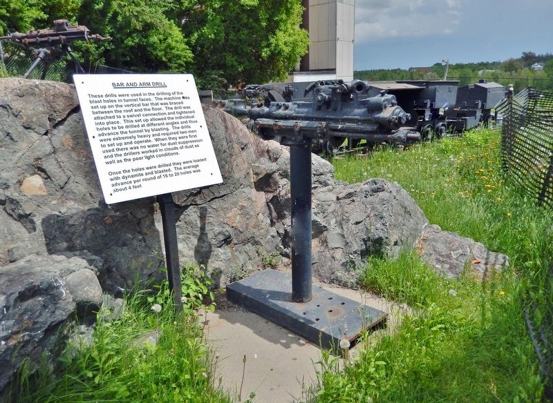
Bar and Arm Drill & Marker
GEOGRAPHIC SORT Title Sort Marker Number Sort Marker Number Sort N Marker Number Sort T Publication Order Sort Publication Order Sort A Erected Year Sort Most Viewed Sort Most Recent-Interest Sort Most Recently Changed Sort SEE FAQ #33 FOR DESCRIPTIONS
On Silver Street just north of Bunker Lane, on the right when traveling north.
Near Silver Street just north of Bunker Lane, on the right when traveling north.
On Argentite Street (Commission Street) just north of Bunker Lane, on the right when traveling north.
On Silver Street just north of Bunker Lane, on the right when traveling north.
On Silver Street just north of Bunker Lane, on the right when traveling north.
On Silver Street just north of Bunker Lane, on the right when traveling north.
On Silver Street at Bunker Lane, on the right when traveling north on Silver Street.
On Argentite Street (Commission Street) just north of Bunker Lane, on the right when traveling north.
Near Silver Street just north of Bunker Lane, on the right when traveling north.
Near Coleman Road, 0.2 kilometers south of Nipissing Road when traveling south.
Near Silver Street just north of Bunker Lane, on the right when traveling north.
On Silver Street just north of Bunker Lane, on the right when traveling north.
On Silver Street at Bunker Lane, on the left when traveling north on Silver Street.
Near Miller Avenue (Provincial Highway 11B) at Galena Street, on the right when traveling west.
On Presley Street at Bunker Lane, on the right when traveling south on Presley Street.
Paid Advertisement
On Miller Avenue (Provincial Highway 11B) at Galena Street, on the right when traveling west on Miller Avenue.
Near Silver Street just north of Bunker Lane, on the right when traveling north.
On Silver Street just north of Bunker Lane, on the right when traveling north.
On Lang Street, 0.2 kilometers north of Argentite Street, on the left when traveling north.
On Trans-Canada Highway (Provincial Highway 11) 0.8 kilometers north of Armstrong 6 Concession (Mini Farm Road), on the left when traveling north.
On 4th Avenue at 3rd Street, on the right when traveling west on 4th Avenue.
On Railroad Street just east of 3rd Street, on the left when traveling east.
On Railroad Street just east of 3rd Street, on the left when traveling east.
On 5th Avenue at 2nd Street, on the right when traveling west on 5th Avenue.
On Main Street at Georgina Avenue, on the right when traveling west on Main Street.
On Georgina Avenue at Main Street, on the right when traveling south on Georgina Avenue.
On Main Street at Georgina Avenue, on the right when traveling west on Main Street.
On Main Street at Georgina Avenue, on the right when traveling east on Main Street.
Near Toburn Road, 0.2 kilometers west of Government Road East (Trans-Canada Highway) (Provincial Highway 66), on the left when traveling west.
Near Toburn Road, 0.2 kilometers west of Government Road East (Trans-Canada Highway) (Provincial Highway 66), on the left when traveling west.
On Government Road East (Trans-Canada Highway) (Provincial Highway 66) 0.1 kilometers east of Duncan Avenue South, on the right when traveling east.
Paid Advertisement
Near Toburn Road, 0.2 kilometers west of Government Road East (Trans-Canada Highway) (Provincial Highway 66), on the left when traveling west.
Near Toburn Road, 0.2 kilometers west of Government Road East (Trans-Canada Highway) (Provincial Highway 66), on the left when traveling west.
Near Toburn Road, 0.2 kilometers west of Government Road East (Trans-Canada Highway) (Provincial Highway 66), on the left when traveling west.
Near Toburn Road, 0.2 kilometers west of Government Road East (Trans-Canada Highway) (Provincial Highway 66), on the left when traveling west.
On Government Road East (Provincial Highway 66) 0.1 kilometers east of Toburn Road, on the left when traveling east.
On Government Road West (Trans-Canada Highway) (Provincial Highway 66) at Chateau Drive, on the left when traveling east on Government Road West (Trans-Canada Highway).
On Kirkland Street West just west of Duncan Avenue South, on the left when traveling west.
Near Toburn Road, 0.2 kilometers west of Government Road East (Trans-Canada Highway) (Provincial Highway 66), on the left when traveling west.
Near Toburn Road, 0.2 kilometers west of Government Road East (Trans-Canada Highway) (Provincial Highway 66), on the left when traveling west.
Near Toburn Road, 0.2 kilometers west of Government Road East (Trans-Canada Highway) (Provincial Highway 66), on the left when traveling west.
Near Toburn Road, 0.2 kilometers west of Government Road East (Trans-Canada Highway) (Provincial Highway 66), on the left when traveling west.
On Main Street (Trans-Canada Highway) (Provincial Highway 11) 0.1 kilometers north of McLeod Avenue, on the right when traveling north.
Near Main Street (Trans-Canada Highway) (Provincial Highway 11) at McLeod Avenue, on the right when traveling north.
On Main Street (Trans-Canada Highway) (Provincial Highway 11) 0.1 kilometers McLeod Avenue, on the right when traveling north.
On Main Street (Trans-Canada Highway) (Provincial Highway 11) 0.1 kilometers north of McLeod Avenue, on the right when traveling north.
On Riverside Drive, 0.2 kilometers east of May Street South.
Paid Advertisement
On Whitewood Avenue West at Wellington Street South, on the right when traveling east on Whitewood Avenue West.
On Whitewood Avenue West at Wellington Street South, on the right when traveling east on Whitewood Avenue West.
On Trans-Canada Highway (Provincial Highway 11) at Poly Ure Road (Armstrong 3 Concession), on the right when traveling north on Trans-Canada Highway.
Near Trans-Canada Highway (Provincial Highway 11) 0.8 kilometers north of Route 570, on the right when traveling north.
Near Trans-Canada Highway (Provincial Highway 11 at milepost 595), 0.7 kilometers north of Provincial Highway 570, on the right when traveling north.