By Mark Hilton, January 21, 2014
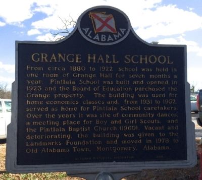
Grange Hall School Marker
RANKED BY RELEVANCE, THEN GEOGRAPHICALLY
| On Federal Road (County Route 24) 0.1 miles west of Mobile Highway (U.S. 31), on the left when traveling west. |
| On West Water Street at North Kalamazoo Mall, on the right when traveling west on West Water Street. |
| On New York State Route 230, 0.1 miles east of Keuka Hill Road, on the right when traveling east. |
| On State Highway 2 at milepost 273, on the right when traveling east. |
| On U.S. 15 at East Blind Road, on the right when traveling north on U.S. 15. |
| On Winnegamie Drive (County Highway BB) east of Municipal Drive (State Highway 76), on the right when traveling west. |
| On route Flavie-Drapeau just east of route de la Mer, on the left when traveling east. |
| On West 141st Street. Reported permanently removed. |
| On West 141st Street at Hamilton Terrace, on the right when traveling east on West 141st Street. |
| Near Hamilton Terrace at West 141st Street, on the right when traveling south. |
| On West 141st Street at Hamilton Terrace, on the right when traveling east on West 141st Street. |
| Near West Whittier Street west of South Front Street. |
| On Eden Avenue west of Grange Road, on the right when traveling west. |
| On New York State Route 311, 0.1 miles east of Maple Avenue, on the left when traveling west. |
| On Dickinson Street at Bridge Street (Provincial Highway 8), on the left when traveling south on Dickinson Street. |
| On Mystic Road, 0.1 kilometers south of Walbridge Road, on the right when traveling south. |
| On Rue Notre Dame (Québec Route 148) 0.4 kilometers west of Côte Angèle, on the right when traveling west. |
| Near High Street at Castle Gate, on the left when traveling east. |
| On Front Street near East Prospect Avenue, on the right when traveling east. |
| On State Highway 49, on the left when traveling north. |
| On Kilgore Road, on the left when traveling north. |
| On La Grange Road at Yosemite Boulevard (California Route 132), on the right on La Grange Road. |
| On Yosemite Boulevard (State Highway 132), on the left when traveling east. |
| On Yosemite Boulevard (Highway 132), on the left when traveling east. |
| On Lake Road south of Yosemite Boulevard (California Highway 132), on the left when traveling south. |
| On Yosemite Boulevard (State Highway 132), on the right when traveling east. |
| On Flota Road west of Yosemite Boulevard (California Highway 132), on the left when traveling west. |
| On Highway 299, on the right when traveling east. |
| On Loma Rica Road at Summit Avenue, on the left when traveling north on Loma Rica Road. |
| On Huntington Street at Shelton Avenue (Connecticut Route 108), on the left when traveling north on Huntington Street. |
| On Norfield Road at Hedgerow Common, on the left when traveling east on Norfield Road. |
| On Maple Street (Route 140) at Church Street, on the left when traveling west on Maple Street. |
| On Main Street (Connecticut Route 286) at Park Street, on the right when traveling west on Main Street. |
| On 4th Street Northwest at Madison Drive Northwest, on the right when traveling south on 4th Street Northwest. |
| On Pine Street near U.S. 95, on the right when traveling south. |
| On Sherwood Road at Oak Avenue, on the right when traveling south on Sherwood Road. |
| On North La Grange Road (U.S. 12/45) north of Woodlawn Avenue. |
| Near North La Grange Road (U.S. 12/45). |
| On Cox Mill Road (State Highway 695) 0.3 miles south of Pierce Lane, on the right when traveling north. |
| On Kentucky Route 111 at City Road, on the left when traveling north on State Route 111. |
| On South Walnut Avenue at East Washington Street, on the right when traveling north on South Walnut Avenue. |
| On Harrington Road (U.S. 1) at Station Road, on the right when traveling north on Harrington Road. |
| On Woodsboro Pike (State Highway 194) at Devilbliss Bridge Road, on the right when traveling north on Woodsboro Pike. |
| On Main Street (Massachusetts Route 6) 0.1 miles south of Brewster Road, on the right when traveling north. |
| On Plymouth Street at Hemlock Lane, on the right when traveling west on Plymouth Street. |
| Near Cochran Avenue (Business Interstate 69) at Tirrell Highway. |
| On West Main Street at West Main Street, on the right when traveling west on West Main Street. |
| On Center Road (Michigan Route 37) 2 miles north of Tompkins Road, in the median. |
| On E. Church Street, on the left when traveling east. |
| On County Road 215 (52nd Street) at 84th Avenue, on the left when traveling north on County Road 215 (52nd Street). |
| On Lakeview Avenue at 6th Street, on the right when traveling north on Lakeview Avenue. |
| Near East 5th Street, 0.5 miles east of Bluff Street, on the left when traveling east. |
| On U.S. 10 at Kelly Farm Road, on the right when traveling east on U.S. 10. |
| Near Main Street (Business U.S. 61) east of West South Street, on the right when traveling north. |
| On Washington Street at 2nd Street, on the right when traveling west on Washington Street. |
| On Walnut Street at Memorial Drive (Rue des Granges), on the left when traveling east on Walnut Street. |
| On Mound Street, on the left when traveling east. |
| On Seashore Road (County Road 626) 0.4 miles north of Academy Road (County Road 639), on the right when traveling north. |
| On Pittstown Road just south of Locust Grove Road, on the right when traveling south. |
| On Bridge Street (New York State Route 396) west of New York State Route 9W, on the left when traveling west. |
| On U.S. 62, 0.1 miles north of Cherry Creek Hill Road (County Route 6), on the right when traveling south. |
| On Lake Road (County Road 157) at Center Road, on the right when traveling south on Lake Road. |
| On U.S. 9, 0.1 miles north of Commons Road (County Route 6), on the left when traveling north. |
| On Charles Coleman Boulevard, 0.1 miles south of Orchard Street, on the right when traveling south. |
| On Main Street (New York State Route 39 at milepost 5.1), 0.2 miles west of Jenings Road (County Route 487), on the right when traveling east. |
| On East Ridge Road (County Route 241) west of Brambury Drive, on the right when traveling east. |
| On East Main Street (New York State Route 404) at Kircher Park, on the right when traveling west on East Main Street. |
| On West 141st Street near St. Nicholas Avenue. |
| On West 141st Street west of St Nicholas Avenue, on the left when traveling west. |
| On East Lake Road (New York State Route 41) at Nunnery Rd. on East Lake Road. |
| On Main Street at Plank Road (County Route 40), on the left when traveling north on Main Street. |
| On North Mansion Road at Duane Lake Road, on the right when traveling north on North Mansion Road. |
| On Broadway Ave. north of Montauk Hwy, on the right when traveling south. |
| On Montauk Highway at Higbie Lane on Montauk Highway. |
| On North Street (New York State Route 13) just north of E Main Street, on the right when traveling north. |
| On Lockville Road at Park Alley, on the right when traveling north on Lockville Road. |
| On County Road 102, on the left when traveling north. |
| On County Route 102 when traveling north. |
| On Ohio Route 58, 0.2 miles north of Ohio Route 162, on the right when traveling south. |
| On Darrow Road (Ohio Route 91) near Aurora Road (Ohio Route 82), on the right when traveling south. |
| On A Street at 5th Street, on the right when traveling east on A Street. |
| On Fort Rock Road, on the left when traveling east. |
| On Valley Forge Park Road (Pennsylvania Route 23), on the left when traveling east. |
| On Main Street/Ridge Pike (Old U.S. 422) 0.1 miles east of 3rd Avenue (Pennsylvania Route 113), on the left when traveling west. |
| On Pennsylvania Avenue (U.S. 209) at Delaware Drive, on the left when traveling north on Pennsylvania Avenue. |
| On Pennsylvania Avenue (U.S. 6/209) south of 8th Street, on the right when traveling south. |
| On Pennsylvania Avenue (U.S. 209) at Delaware Drive, on the right when traveling north on Pennsylvania Avenue. |
| On Pennsylvania Route 154. |
| On Pennsylvania Route 136 west of Gamble Street, on the left when traveling east. |
| On Pennsylvania Route 136 west of Gamble Street, on the right when traveling west. |
| On SC Highway 184, on the right when traveling north. |
| On Dennis Dairy Road, on the left when traveling north. |
| On 3rd Street (State Highway 57), on the right when traveling east. |
| On North Washington Street at West La Fayette Street, on the right when traveling north on North Washington Street. |
| On North Washington Street at West Colorado Street, on the left when traveling north on North Washington Street. |
| Near County Highway 1208, 0.2 miles south of Farm to Market Road 916. |
| On Vermont Route 110 at North Common Street, on the left when traveling south on State Route 110. |
| On Iron Bridge Road (Virginia Route 10) at Krause Road, on the right when traveling east on Iron Bridge Road. |
| On 2nd Street at Calhoun Street, on the right when traveling south on 2nd Street. |
| On Coulee Hite Road, on the right when traveling west. |
350 entries matched your criteria. The first 100 are listed above.
Next 100 ⊳
* Inflectional forms of words are their plurals, singulars, and possessives as well as gramatical tenses and similar variations.