By Tim & Renda Carr, October 17, 2010
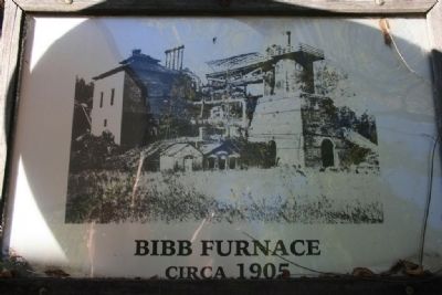
Bibb Furnace Marker (Center Marker)
GEOGRAPHIC SORT Title Sort Marker Number Sort Marker Number Sort N Marker Number Sort T Publication Order Sort Publication Order Sort A Erected Year Sort Most Viewed Sort Most Recent-Interest Sort Most Recently Changed Sort SEE FAQ #33 FOR DESCRIPTIONS
On Furnace Road (County Road 62) south of Montevallo Road (State Route 25).
On Janney Road, 0.1 miles east of Spring Road, on the left when traveling east.
On County Route 29 at County Route 45, on the right when traveling north on County Route 29.
On Stone River Road north of Old Leeds Lane, on the left when traveling north.
On Parkway Drive at North Mall, in the median on Parkway Drive.
On South Main Street at Mildred Street, on the right when traveling north on South Main Street.
On Bucksville Road (Alabama Route 216) east of Interstate 59/20, on the right when traveling east.
Near Confederate Parkway.
Near Lower Road at Furnace Hill Road, on the left when traveling west.
On U.S. 60 at Old River Road, on the left when traveling west on U.S. 60.
On Kentucky Route 36, on the left when traveling north.
On Main Street (Kentucky Route 211), on the right when traveling north.
On Winchester Avenue (Business U.S. 23) at 23rd Street, on the left when traveling east on Winchester Avenue.
On Bellefonte-Princess Road (Kentucky Route 5) at Princess Drive and Oxcart Road, on the left when traveling south on Bellefonte-Princess Road.
Paid Advertisement
On Kentucky Route 5 at Straight Creek Road, on the left when traveling north on State Route 5.
On Kentucky Route 5 at Princess Drive, on the left on State Route 5.
On Kentucky Route 3 just south of Bolts Fork Road (Kentucky Route 773), on the left when traveling south.
On Preston Highway (Kentucky Route 61) at Beech Grove Road (County Route 1494), on the left when traveling north on Preston Highway.
On Pioneer Drive, 1 mile south of East Pioneer Drive, on the left when traveling south.
On State Highway 121 at Cypress Trail, on the right when traveling north on State Highway 121.
On West 5th Street (Kentucky Route 8), in the median.
On Hitchens Road (Kentucky Route 1) south of East Main Street (U.S. 60), on the right when traveling south.
On Carol Malone Road (Kentucky Route 1) 1 mile north of Interstate 64, on the right when traveling south.
On U.S. 60 just west of Clay Hollow Road, on the left when traveling west.
On Main Road at Warehouse Road on Main Road.
On Kentucky Route 1 north of Big Lost Creek Road (Kentucky Route 784), on the right when traveling north.
On Kentucky Route 7 at Brushy Road, on the right when traveling south on State Route 7.
On Kentucky Route 1 at Laurel Road, on the left when traveling north on State Route 1.
On U.S. 23 at Legion Drive, on the right when traveling east on U.S. 23.
Paid Advertisement
On U.S. 23 west of Ashland Drive (Kentucky Route 1725), on the right when traveling east.
On U.S. 23 at Little Rocky Road (Kentucky Route 1043), on the right when traveling east on U.S. 23.
On U.S. 31E at Aetna Furnace Highway (Kentucky Highway 936), on the right when traveling north on U.S. 31E.
On Main Street (U.S. 31W) at East Union Street (State Highway 357), on the left when traveling south on Main Street.
On Kentucky Route 2565 north of Kentucky Route 644, on the right when traveling north.
On Old Ferry Road (Forest Road 117) at Forest Road 122, on the right when traveling north on Old Ferry Road.
On Kentucky Route 810 south of Rusty Ridge Road, on the right when traveling south. Reported damaged.
On Lake Barkley Drive (Kentucky Route 295) south of Mint Spring Drive, on the left when traveling south.
On Kentucky Route 810 near U.S. 62, on the right when traveling south.
On South 3rd Street (Business U.S. 60) at Norton Street, on the left when traveling south on South 3rd Street.
On Old Beaver Road (Kentucky Route 1274) 6.4 miles east of Kentucky Route 36, on the right when traveling east.
On John Prine Avenue (U.S. 431) north of East Mose Rager Avenue (State Route 176), on the right when traveling north.
On East Main Street (Maryland Route 36) at Bridge Street, on the right when traveling south on East Main Street.
On Catoctin Furnace Road (Maryland Route 806) at Red Bird Lane (Route 806), on the right when traveling south on Catoctin Furnace Road.
On Catoctin Furnace Road (Maryland Route 806) south of Red Bird Lane, on the right when traveling south.
Paid Advertisement
On Blacks Mill Road at Catoctin Furnace Road (Maryland Route 806) on Blacks Mill Road.
Near Park Central Road north of Foxville Road (Maryland Route 77), on the right when traveling north.
On Maple Street at Water Street, on the right when traveling west on Maple Street.
On Main Street (New Hampshire Route 116) 0.1 miles south of Sugar Hill Road (New Hampshire Route 117), on the left when traveling north.
On Main Street (New Hampshire Route 116) 0.1 miles south of Sugar Hill Road (New Hampshire Route 117), on the right when traveling south.
Near Greenwood Lake Turnpike, on the right when traveling west.
On Standish Rd at Depot Rd. on Standish Rd.
On New York State Route 9 north of South Junction Road, on the right when traveling south.
Near Old Forge Rd close to Sterling Lake Road, on the left when traveling north.
On Main Street (State Highway 89) at Shepherd Mill Road, on the left when traveling south on Main Street.
Near Shepherd Mill Road, on the right when traveling east.
On Main Street at Butcher Road, on the right when traveling north on Main Street.
On Lisbon Street at 1st Street on Lisbon Street.
On Buckeye Park Road (County Road 167) 0.3 miles north of Buckeye Road (County Road 165), on the right when traveling north.
On Buckeye Park Road (Local Road 167) at Buckeye Road (Local Road 165), on the left when traveling south on Buckeye Park Road. Reported missing.
Paid Advertisement
On Buckeye Park Road (County Road 167) 0.2 miles north of Buckeye Road (County Road 165), on the right when traveling north.
On Buckeye Road (County Road 165) 0.1 miles east of Buckeye Park Road (County Road 167), on the right when traveling east.
On Buckeye Park Road (County Road 167) 0.2 miles north of Buckeye Road (County Road 165), on the right when traveling north.
On Buckeye Park Road (County Road 167) 0.2 miles north of Buckeye Road (County Road 165), on the right when traveling north.
On Buckeye Park Road (County Road 167) 0.1 miles north of Buckeye Road (County Road 165), on the right when traveling north.
On Buckeye Park Road (Local Road 167) at Buckeye Road (Local Road 165) on Buckeye Park Road. Reported permanently removed.
On Buckeye Park Road (County Road 167) just north of Buckeye Road (County Road 165), on the left when traveling north.
On Buckeye Park Road (County Road 167) 0.2 miles north of Buckeye Road (County Road 165), on the right when traveling north.
On Buckeye Park Road (County Road 167) 0.2 miles north of Buckeye Road (County Road 165), on the right when traveling north.
On Buckeye Park Road (County Road 167) 0.2 miles north of Buckeye Road (County Road 165), on the left when traveling north.
On Buckeye Park Road (Local Route 167), on the left when traveling south. Reported permanently removed.
Near Buckeye Park Road (County Road 167) at Buckeye Road (County Road 165), on the right when traveling north.
On Buckeye Park Road (County Road 167) 0.2 miles north of Buckeye Road (County Road 165), on the right when traveling north.
Reported permanently removed.
On Buckeye Park Road (County Road 167) 0.2 miles north of Ridgeland Road (County Road 165), on the right when traveling east.
Reported permanently removed.
Paid Advertisement
On Buckeye Park Road (County Road 167) 0.2 miles north of Ridgeland Road (County Road 165), on the right when traveling north.
On Park Avenue at 4th Street, on the right when traveling west on Park Avenue.
On Route 93 north of Kimble Creek Road (County Route 258), on the left when traveling north.
On Wetmore Drive, 0.2 miles east of Poland Avenue, on the right when traveling east.
On Bayard Street at Amberson Avenue, on the right when traveling east on Bayard Street.
Near Three Rivers Heritage Trail.
Near West Station Square just east of Commerce Drive, on the right when traveling west.
On Zelienople Road (Pennsylvania Route 288) at Old Furnace Road, on the left when traveling north on Zelienople Road.
Near State Steet at Roberts Street, on the right when traveling south.
On East Main Street (Pennsylvania Route 345/724) just east of North Mill Street, on the left when traveling east.
On East Main Street (Pennsylvania Route 345) just west of North Water Street, on the right when traveling west.
Paid Advertisement
On South Reading Avenue at Farmington Avenue on South Reading Avenue.
On Penn Avenue (U.S. 422) at Freeman Street, on the right when traveling east on Penn Avenue.
On Crescent Road at Union Avenue (Pennsylvania Route 36), on the right when traveling west on Crescent Road.
141 entries matched your criteria. The first 100 are listed above.
The final 41 ⊳