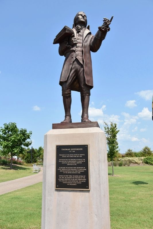
President of the United States of America, served two terms from 1801-1809
Jefferson was the principal author of the Declaration of Independence, a Charter of America and Universal Liberties
Drafted in 1776.
He became the Nation's First . . . — — Map (db m106069) HM
Lewis County
Established 1843; named in honor of
Meriwether Lewis
Captain in the Army of the United States and one time secretary to President Jefferson. Later, co-commander of the Lewis & Clark Expedition to the Pacific Northwest. . . . — — Map (db m148455) HM
The Lewis and Clark Expedition and Fort Southwest Point
The Lewis and Clark Expedition (1804-06) was conceived by President Thomas Jefferson to be an exploration of discovery through the West and on to the Pacific Ocean. The purposes of the . . . — — Map (db m159794) HM
A.Claiborne Landing
Mile 188.3 AHP
This was the plantation home of William C.C. Claiborne. At the age of 21, Claiborne helped write a constitution for the new state of Tennessee and five years later President Jefferson appointed him . . . — — Map (db m114995) HM
(South face)
As we, the citizens of the City of Millington, celebrate our Centennial, we believe that it is most appropriate to offer fervent thanks and humble appreciation to those of our area who have served in our Armed Forces. Without . . . — — Map (db m148572) WM
General Evan Shelby erected a fort here in 1771 that sheltered and protected pioneers and sent victorious forces to the battles of Point Pleasant, Long Island Flats and Chicamauga Towns
Here was conceived by Shelby, Campbell and Sevier, an . . . — — Map (db m35794) HM
Established in 1845. Named
in honor of Thomas Jefferson
(1743–1826)
Author of the Declaration
of Independence of the
United States
Early navigation headquarters on Cypress Bayou. County seat of Marion County since 1860. . . . — — Map (db m110996) HM
This strategic point on Lake Champlain was occupied by Native Americans for thousands of years. In 1690 Jacobus deWarm build a small stone fort here. The French build a wooden stockade in 1731, erecting Fort St. Frederic across the lake in 1734. . . . — — Map (db m85414) HM
Hiram Powers, one of the most famous nineteenth century sculptors, was born in 1805 in a farmhouse that stood on this hillside. Although he went west with his family at a young age, and took up residence in Florence, Italy, in 1837, Powers always . . . — — Map (db m32221) HM
Albemarle County. Albemarle County was formed in 1744 from Goochland County and named for William Anne Keppel, the second Earl of Albemarle, titular governor of Virginia from 1737 to 1754. A portion of Louisa County was later added to . . . — — Map (db m4030) HM
Albemarle County. Albemarle County was formed in 1744 from Goochland County and named for William Anne Keppel, the second Earl of Albemarle, titular governor of Virginia from 1747 to 1754. A portion of Louisa County was later added to . . . — — Map (db m21585) HM
Extending from the Orange County line on the north to the outskirts of Charlottesville with the Southwest Mountains forming its spine, this historic district encompasses more than 31,000 acres and contains some of the Piedmont’s most pristine and . . . — — Map (db m40775) HM
Such relationships ranged from acknowledged affairs that...were familial in every sense but a legally recognized one to brutal acts of rape and sexual assault where slave owners showed the inhumanity for which slavery was notorious. . . . — — Map (db m231159) HM
Despite the horrors of slavery, African Americans forged enduring family and community connections, and cultural and spiritual practices. The Contemplative Site is a space to reflect upon their lives and legacies.
Thomas Jefferson held at . . . — — Map (db m231012) HM
Isaac Granger Jefferson worked the forge in the original building on this site, which housed a "storehouse for iron" in 1796, a short-lived tinsmithing operation, a small nail-making shop, and also served as quarters for enslaved people. The use . . . — — Map (db m231059) HM
Born in slavery at Monticello on July 4, 1826, the day of Thomas Jefferson's death, Henry Martin worked at the University in various capacities from about 1847 until his retirement in 1910. In late 1868 or early 1869, he was employed as head . . . — — Map (db m75526) HM
Master carpenter James Dinsmore oversaw construction of this Ice House to Jefferson's design in 1802. Enslaved and hired workers filled it each year between November and February with ice cut from the nearby Rivanna River, shallow ponds, or snow . . . — — Map (db m68174) HM
In 1788 James Monroe purchased an 800-acre farm here to be close to his friend Thomas Jefferson and to establish a law office. In 1799 the Monroes moved to their new Highland plantation adjacent to Monticello and sold the first farm. In 1817 the . . . — — Map (db m8762) HM
Jefferson's elaborate design for Monticello could not have been achieved without the superior craftsmanship of hired free and enslaved woodworkers working closely together. Joiners, the most skilled, produced Monticello's classically inspired . . . — — Map (db m230977) HM
... architecture is my delight, and putting up, and pulling down, one of my favourite amusements.
Thomas Jefferson quoted by Margaret Bayard Smith, 1809
Thomas Jefferson shaped American architecture with his neoclassical designs . . . — — Map (db m231048) HM
Every article is made on his farm; his negroes are cabinet makers, carpenters, masons, bricklayers, smith, etc. Duc de La Rochefoucauld Liancourt, 1796
You are standing on Mulberry Row, a road once lined with more . . . — — Map (db m68171) HM
Jefferson set up a nail-making operation in 1794 to provide income until he could “put my farms into a course of yielding profit.” He calculated the nailers’ daily output, the waste of nailrod, and profits. In its first years, the . . . — — Map (db m80862) HM
Although both the North and South Pavilions were elements in Jefferson's designs of the 1770's for Monticello, it was not until 1808 that his scheme was fully realized with the completion of this structure. After Jefferson's daughter Martha and . . . — — Map (db m231029) HM
Though enslaved, Sally Hemings helped shape her life and the lives of her children, who got an almost 50-year head start on emancipation, escaping the system that had engulfed their ancestors and millions of others. Whatever we may feel about . . . — — Map (db m231286) HM
Jefferson called this brick structure, the first building on the mountaintop, his "outchamber." Erected in 1770, it contained one room over a kitchen. Jefferson lived here alone until his marriage to Martha Wayles Skelton in January 1772. They . . . — — Map (db m231033) HM
Panel 1 Jefferson introduced mechanized cloth production to his plantation when trade embargoes and looming war cut off the supply of imported British cloth. In 1811, he hired William McLure, a free white artisan and "a very ingenious man," . . . — — Map (db m68175) HM
After Jefferson's death in 1826, his heirs sold his property, including his slaves, to pay his debts. Naval officer Uriah Phillips Levy, who admired Jefferson for his support of religious liberty, purchased Monticello in 1834 to preserve it. This is . . . — — Map (db m80808) HM
This graveyard had its beginning in an agreement between two young men, Thomas Jefferson and Dabney Carr, who were school-mates and friends. They agreed that they would be buried under a great oak which stood here.
Carr, who married Jefferson's . . . — — Map (db m80807) HM
The greatest advocate of human liberty
Opposing special privileges
He loved and trusted The People
To commemorate his
Purchase of Louisiana
Erected by
The Jefferson Club
of St. Louis MO
on their pilgrimage Oct 12, 1901
to . . . — — Map (db m99849) HM
Proclaim Liberty throughtout the land unto the inhabitants thereof —Leviticus XXIV.
This monument to Thomas Jefferson was presented to the people to perpetuate the teachings and examples of the Founders of the . . . — — Map (db m8805) HM
Thomas Jefferson's garden was a massive, edible laboratory. He tested new plants to record which fruit and vegetable varieties thrived. Like his neighbors, Jefferson designed a robust vegetable garden to provide food for his household. . . . — — Map (db m231112) HM
These garden walls,
included by Thomas Jefferson in his original designs for the academical village, were built by enslaved laborers.
The walls were reconstructed and enclosed gardens planted by
The Garden Club of Virginia
1952 . . . — — Map (db m230924) HM
Thomas Jefferson founded the University of Virginia. The cornerstone of its first building was laid on October 6, 1817, in the presence of three presidents of the United States—Jefferson, James Madison, and James Monroe. In 1825, the . . . — — Map (db m61101) HM
Bounded by the James River to the south and the Rivanna River to the north, this nationally significant district encompasses 83,627 acres. Listed on the National Register of Historic Places in 2007, it includes buildings influenced by Jefferson’s . . . — — Map (db m23240) HM
The vestry of Fredericksville Parish commissioned a church for this site in 1745. First known as Middle Church, the wood-frame building was later called Walker's Church. Thomas Jefferson attended the nearby classical school of the Rev. James Maury, . . . — — Map (db m170120) HM
Extending from the Orange County line on the north to the outskirts of Charlottesville with the Southwest Mountains forming its spine, this historic district encompasses more than 31,000 acres and contains some of the Piedmont’s most pristine and . . . — — Map (db m17447) HM
Just north was a classical school conducted by the Rev. James Maury, rector of Fredericksville Parish from 1754 to 1769. Thomas Jefferson was one of Maury’s students. Matthew Fontaine Maury, the “Pathfinder of the Seas,” was Maury’s . . . — — Map (db m17459) HM
Just to the south was Mount Warren, the home of Wilson Cary Nicholas. He served in the Continental army, represented Albemarle County in the General Assembly (1784–1789, 1794–1799), and was a delegate to the Virginia Convention of 1788 . . . — — Map (db m19406) HM
Thomas Jefferson—author of the Declaration of Independence, third president of the United States, and founder of the University of Virginia—was born near this site on 13 April 1743. His father, Peter Jefferson (1708–1757), a surveyor, planter, and . . . — — Map (db m17306) HM
This estate was the home of James Monroe, fifth president of the United States. In 1793, James and Elizabeth Kortright Monroe purchased 1,000 acres adjoining Jefferson’s Monticello. Called Highland, the plantation, eventually totaling 3,500 acres, . . . — — Map (db m23437) HM
Noted lawyer and statesman William Branch Giles was born 12 Aug. 1762 in Amelia County and educated at Hampden-Sydney College, Princeton, and the College of William and Mary. Giles served Virginia in the United States House of Representatives . . . — — Map (db m19039) HM
Near here lived Anthony and Benjamin Rucker,
inventors of the James River batteau, which
superseded the double dugout canoe and rolling
road for transporting tobacco hogsheads. These
long (about 50 or 60 feet), double-ended vessels
dominated . . . — — Map (db m46342) HM
The oldest trees in this forest probably began growing around 1865. Before that time, most of the trees along Arlington's Palisades were cut down to establish a clear line of sight for the Civil War fortifications surrounding Washington. The most . . . — — Map (db m186870) HM
Thomas Jefferson designed the sunken lawn to accommodate the lower level of the house and form an area similar to a plain parterre or bowling green. Enslaved laborers led by Phil Hubbard, working on their own time for pay, excavated the lawn and . . . — — Map (db m99784) HM
Nearby are buried several prominent area settlers and their descendants. Col. William Callaway, in 1755 one of the first two members of the Virginia House of Burgesses from Bedford County, donated the hundred acres of land on which the town of New . . . — — Map (db m65605) HM
Near here is Santillane, one of Botetourt County’s
most distinguished properties. The Greek Revival house sits on a tract of land originally
owned by Colonel George Hancock, a member
of the United States Congress from 1793-1797.
In 1808 . . . — — Map (db m84203) HM
Designed by Thomas Jefferson in 1821, Burned in 1869, Rebuilt in 1878. The exterior follows Jefferson’s plan with the interior redesigned. Copy of original plan and specifications on display in courthouse. Registered in 1969 as a National and . . . — — Map (db m15689) HM
Designed by Thomas Jefferson in 1821, burned in 1869, rebuilt in 1873. The exterior follows Jefferson’s plan with the interior redesigned. Copy of original plan and specifications on display in courthouse. Registered in 1969 as a National and . . . — — Map (db m21108) HM
“I have taken the liberty to trespass upon your time and talents (a common stock) which we all seem to have a right to draw upon, …to draft for us a plan of our Court house,…” Source: Letter from Colonel Charles Yancey to . . . — — Map (db m67321) HM
“When buildings are of durable materials, every new edifice is an actual and permanent acquisition to the state, adding to its value as well as to its ornament…” Source: Thomas Jefferson, Notes on Virginia
8
The . . . — — Map (db m67322) HM
“Buckingham County, 26th February, 1869
A Editor’s dispatch: sad calamity has befallen our country. The court-house was set fire yesterday morning at about 1 o’clock, and by daylight was a mass of ruins.” Source: Richmond . . . — — Map (db m67320) HM
Approximately 2 miles east stood Millbrook (1811-1866), home of U.S. Senator John Wayles Eppes (1773-1823). He attended the University of Pennsylvania, was graduated from Hampden-Sydney College, and was admitted to the Bar in 1794. He married Maria, . . . — — Map (db m28305) HM
Just south across Little Beaver Creek stand the ruins of the last of three Oxford Iron Works furnaces built in the vicinity. Virginia and Pennsylvania investors began the ironworks nearby between 1768 and 1772 as a small bloomery forge. According to . . . — — Map (db m42897) HM
Hazelwood was the home plantation of John Taylor of Caroline (1753-1824), agricultural reformer and political theorist. Taylor studied law under his uncle, the jurist Edmund Pendleton, and was an officer in the Revolutionary War. He served in the . . . — — Map (db m186681) HM
During the 18th century this property was established as a Southall family seat. Notable family members include James Barrett Southall, owner of Williamsburg's Raleigh Tavern, Turner Southall, member of the committee to build Thomas Jefferson's . . . — — Map (db m18588) HM
Two miles east is the site of “The Forest,” home of Martha Wayles Skelton, widow of Bathurst Skelton. There she was married to Thomas Jefferson, January 1, 1772. The bridal couple drove in the snow to Jefferson’s home, . . . — — Map (db m86172) HM
After three decades of public service, Patrick Henry retired in 1794 to Red Hill plantation in Charlotte County, which he regarded as "one of the garden spots of the world." He purchased the 700-acre estate and simple story-and-half house in 1794 . . . — — Map (db m128698) HM
One mile to the south is Red Hill, Patrick Henry’s last home and burial place. The marble stone covering his grave carries the simple inscription, “His fame his best epitaph.”
Henry came here in 1794 and died at his beloved Red Hill . . . — — Map (db m65398) HM
The historic district, a rare example of a 19th-century rural courthouse town, is concentrated on two main streets. Begun as Dalstonburg in 1775 during the French and Indian War, and later called Marysville and Smithville, the town was named . . . — — Map (db m31022) HM
Nine miles west is Roanoke, home of John Randolph, a member of the House of Representatives for many years, and Senator. Randolph at first was Jefferson's lieutenant and later on an opponent and critic, but he never lost the love of his . . . — — Map (db m31860) HM
George Nicholas, Albemarle County’s Virginia General Assembly delegate in 1783, built a stone house here in 1784. James Monroe occupied it 1789-1790, while improving the dwelling at his nearby farm, later the site of the University of Virginia. Here . . . — — Map (db m19830) HM
Fernando Bolívar, a native of Venezuela, attended the University of Virginia in 1827. He was the nephew and adopted son of Símon Bolívar, The Liberator, who sent him to study in the “Republic of Washington and Jefferson.” A friend of James Monroe . . . — — Map (db m8820) HM
The Farm stands on a 1020-acre tract acquired by Nicholas Meriwether in 1735 and later owned by Col. Nicholas Lewis, uncle of Meriwether Lewis. A building on the property likely served as headquarters for British Col. Banastre Tarleton briefly in . . . — — Map (db m19582) HM
To the memory and service of three Presidents of the United States
Thomas Jefferson, James Madison and James Monroe
associated with this courthouse in Albemarle County, Virginia — — Map (db m170128) HM
Originally served as the court house and town's public building. Thomas Jefferson referred to it as the "common temple" and was accustomed to attend church services here. The south addition with columns was added after the Civil War. Remodelled and . . . — — Map (db m170125) HM
On 4 June 1781, John “Jack” Jouett Jr. arrived at the Albemarle County Courthouse to warn the Virginia legislature of approaching British troops. The state government under Governor Thomas Jefferson had retreated from Richmond to . . . — — Map (db m18549) HM
Three miles to the southeast, Thomas Jefferson began the house in 1770 and finished it in 1802. He brought his bride to it in 1772. Lafayette visited it in 1825. Jefferson spent his last years there and died there, July 4, 1826. His tomb is there. . . . — — Map (db m65069) HM
This area, known originally as "Cold Water Run," is the site of the first Chesterfield County courthouse, erected in 1750. In 1917 it was demolished and replaced by a larger Georgian Revival brick building that served the county until the 1960s. . . . — — Map (db m19523) HM
Two and one-third miles south stands Eppington, built in the late 1760s by Francis Eppes and his wife Elizabeth Wayles Eppes, half-sister to Martha Wayles Jefferson. Thomas Jefferson frequently visited Eppington. Lucy Jefferson, his daughter, died . . . — — Map (db m28911) HM
One legend says that Thomas Shore, the owner of Violet Bank, planted this tree from a slip given to him by Thomas Jefferson.
General Robert E. Lee was camped here on the morning of July 30, 1864 and heard the explosion of the Crater. — — Map (db m17070) HM
Shortly after the revolutionary conventions held in the spring and summer of 1775, Culpeper County lieutenant James Barbour began organizing a 300-man battalion in the counties of Culpeper, Orange, and Fauquier. Yowell Meadow, then called Clayton's . . . — — Map (db m12703) HM
In 1749 the Virginia House of Burgesses divided Goochland County to establish Cumberland County. William A. Howard, an associate of Thomas Jefferson's master builder, Dabney Cosby, built the present Cumberland County courthouse (1818-1821). The . . . — — Map (db m21121) HM
The famous Thoroughbred racehorse Fearnought, a dominating racer in Great Britain and the foremost colonial-era sire in America, was foaled in England in 1755. In 1764, John Baylor brought him to Newmarket in Caroline County, where he stood at stud . . . — — Map (db m18958) HM
These trees were planted
in commemoration of the
eight Presidents of
the United States
who were sons of Virginia.
George Washington 1789-1797
Thomas Jefferson 1801-1809
James Madison 1809-1817
James Monroe 1817-1825 . . . — — Map (db m241179) HM
Only members of the gentry used the Necessary, commonly known as an outhouse or privy, and likely only in good weather. Chamber pots were used inside the house in evenings and in cold or inclement weather. Slaves removed, emptied, and cleaned the . . . — — Map (db m140945) HM
Famous ordinary believed to be part of Federal-style mansion built on 145 acres bought for $291 in 1787 by James Wren (part of 1742 208-acre G. Harrison grant). Lying north of Alexandria-Leesburg Rolling Road, tavern operated 1789-1815 under James . . . — — Map (db m2842) HM
Thomas Jefferson stated in Notes on the State of Virginia (1782) that he found gold bearing rock weighing approximately four pounds near this site. Among the 19 gold mines that have been in operation since then in the area, the Franklin and the . . . — — Map (db m2730) HM
The nearby Bremo properties include three separate houses, all built by planter, soldier and reformer Gen. John Hartwell Cocke (1780 - 1866) on his family's 1725 land grant. The three properties - Bremo, Lower Bremo, and Recess - and their . . . — — Map (db m28070) HM
Fork Union Baptist Church was constituted in
1798. Presbyterian, Episcopal, Methodist,
and Baptist congregations shared as a place
of worship the current church, built in 1824
and first known as the Brick Meetinghouse.
Gen. John Hartwell Cocke, . . . — — Map (db m18302) HM
Formal white abolitionist societies emerged at the end of the 18th century and the Quakers were the first white abolitionists. However, black abolitionism began when the first African was forcibly extracted from his homeland and shipped to . . . — — Map (db m176108) HM
"After passing through a small town called Falmouth at the Falls of the Rappahannock, we crossed in a Ferry boat and arrived at Fredericksburg, putting up at an In[n] or Public House kept by one Weedon, who is now a General Officer in . . . — — Map (db m148073) HM
(Front) From a meeting in Fredericksburg, January 3-17, 1777, of a Committee of Revisors appointed by the General Assembly of Virginia, composed of Thomas Jefferson, George Mason, Edmund Pendleton, George Wythe and Thomas Ludwell Lee to . . . — — Map (db m1078) HM
On October 7, 1776, three months after the Continental Congress had adopted the Declaration of Independence, the Virginia Assembly held its first session, in Williamsburg. The Assembly appointed Thomas Jefferson and four delegates to a Committee of . . . — — Map (db m1061) HM
John Page, planter, scholar, and Revolutionary patriot, was born in 1743 at Rosewell, three miles west of here. He attended the College of William and Mary with Thomas Jefferson. The two men developed a lifelong friendship and shared an interest in . . . — — Map (db m30115) HM
Seven miles south once stood Dungeness, built about 1730 by Isham Randolph (1685-1742) who was the grandfather of Thomas Jefferson, President of the United States, and of James Pleasants, Governor of Virginia. Sea captain, merchant and planter, . . . — — Map (db m18353) HM
Two miles south is Elk Hill, once owned by Thomas Jefferson. Lord Cornwallis made his headquarters there, June 7-15, 1781; this was the western limit of his invasion. On June 15 he turned eastward, leaving the place pillaged and carrying off slaves. — — Map (db m31605) HM
The present courthouse is the fourth to serve the county and the second to occupy this site. The building was erected in 1826 by Valentine Parrish, a Cumberland builder, and Dabney Cosby, a skilled Staunton brickmason who had worked for Thomas . . . — — Map (db m18371) HM
Perhaps the oldest frame residence on James River west of Richmond, Tuckahoe was begun about 1715 by Thomas Randolph. The little schoolhouse still stands here where Thomas Jefferson began his childhood studies. Famous guests here have included . . . — — Map (db m25625) HM
Greene County. Formed from Orange County in 1838, this rural Piedmont county was named for Gen. Nathanael Greene, Revolutionary War military hero. The county seat of Greene County is Stanardsville. William Donoho and William B. Phillips, . . . — — Map (db m21505) HM
Orange County. Formed from Spotsylvania County in 1734, Orange County, a pastoral Piedmont county, was probably named in honor of William IV, the Dutch prince of Orange, who married Anne, the Princess Royal, daughter of George II of England, . . . — — Map (db m24228) HM
The town of Halifax has been the county seat of Halifax County since 1777. It is named for George Montague, the second Earl of Halifax, an English statesman. Previously this community had been called Banister, Houston, and Halifax Court House. . . . — — Map (db m30974) HM
Scotchtown is best known as the site from which Patrick Henry rode to Richmond in March of 1775 to deliver his infamous “Liberty or Death” speech. . Some have even suggested that the house, where he had been forced to confine his wife . . . — — Map (db m47453) HM
Hanover County was organized in 1720 and named for George I, King of England and former elector of Hanover in Germany. Seventeen years later (between 1737 and 1738), construction of the courthouse structure began and was completed in 1743. The . . . — — Map (db m32691) HM
In December 1763, the Historic Hanover Courthouse was the site of the famous Parsons’ Cause, an opening salvo of the American Revolution. During the Parsons’ Cause trial, Patrick Henry voiced one of the first American objections to denial of the . . . — — Map (db m32692) HM
Upon Patrick Henry’s marriage to Sarah Shelton in 1754, he received for her dowry a 300-acre tract of land and six slaves. Like many Virginians with small farms, Henry labored in the fields with his slaves. Much of the soil at Pine Slash had been . . . — — Map (db m46754) HM
For more than a century the Polegreen Church stood as a monument to the Hanover Dissenters and Samuel Davies in the struggle for religious liberty. Though Davies died fifteen years before the American Revolution, his influence and revolutionary . . . — — Map (db m32674) HM
From Virginia’s founding until the American Revolution 170 years later, the Anglican Church was the only state recognized religion. The government built the churches and the parsonages and paid the clergy with tax money. All other religious groups . . . — — Map (db m32679) HM