National Oceanic and Atmospheric Administration (NOAA) Historical Markers
NOAA's mission is to understand and predict our changing environment, from the deep sea to outer space, and to manage and conserve America's coastal and marine ecosystems and resources.
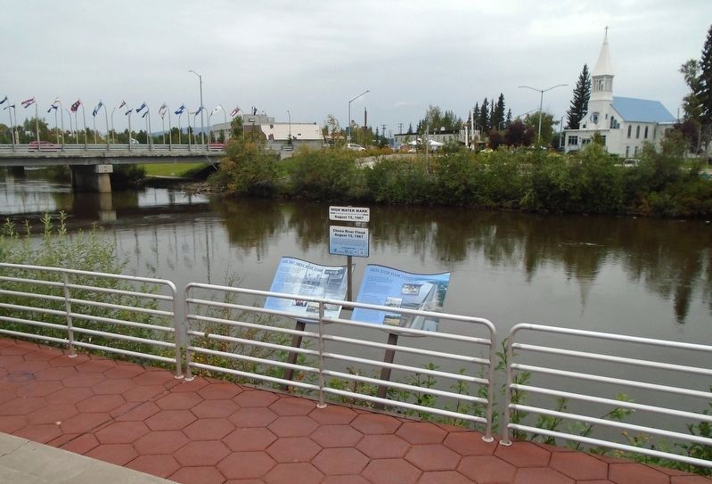
The 1967 flood in Fairbanks made one thing clear-the city and nearby Fort Wainwright needed better flood control.
Planning Ahead
The Chena River has a history of flooding, but the damage from the 1967 flood was so extensive that it . . . — — Map (db m256591) HM
In 1967, Fairbanks experienced the greatest flood in its history, as the Chena River
seemingly swallowed the city whole.
It's Raining, It's Pouring
Fairbanks residents expect cooler and shorter days and a little rain in August, but . . . — — Map (db m256584) HM
[Approach Guidelines are informational and not transcribed]
Unique and Valuable
Tidewater glacier areas are essential habitats for harbor seals in Alaska. Such habitats
are only available to seals in southcentral and . . . — — Map (db m257979) HM
On March 9, 1862, iron met iron for the first time in naval history. During the Battle of Hampton Roads, USS Monitor fought a four-hour battle against the Confederate ironclad, CSS Virginia. Ending in a draw, neither vessel . . . — — Map (db m287080) HM
Harlan & Hollingsworth
Established in 1836, the Wilmington manufacturing firm of Harlan & Hollingsworth led the nation in the construction of iron-hulled ships prior to the Civil War and pioneered many iron fabrication and shipbuilding . . . — — Map (db m287079) HM
This 1800's sketch shows early development around Fort San Marcos de Apalachee at the confluence of the St. Marks and Wakulla Rivers. In 1833, the citizens left this swampy land and moved inland. Today, St. Marks is one of the oldest settlements . . . — — Map (db m186445) HM
(plaque 1)
Land Grant College
Congress, through the Morrill Act of of 1862, donated 210,000 acres of public land to Louisiana to provide a college "For the benefit of Agriculture and the Mechanical Arts." The land and underlying . . . — — Map (db m91023) HM
During the Great Red River Flood of 1945, the Cane River rose and crested 16 feet above it's typical
mean pool elevation of 98.0 on April 10,1945. The brick coursing variation above denotes the level to
which the waters rose during the 1945 flood . . . — — Map (db m175417) HM
"We wasted our inheritance by improvidence and mismanagement and blind confidence."
William K. Brooks, The Oyster, 1891
Vital to Commerce
For over 100 years, oysters were one of the Chesapeake Bay's most valuable commercial . . . — — Map (db m114863) HM
"State sets new record for oyster restoration; 750,000,000 spat placed in rivers that feed the Bay."
The Capital, 2009
Vital to Nature
The native Eastern or American oyster (Crassostrea virginica) is a keystone species . . . — — Map (db m114864) HM
1600's
Captain John Smith and the Jamestown Expedition wrote:
Oysters "lay on the ground as thick as stones."
1700's
Chesapeake traveler Francis Louis Michel wrote:
"The abundance of oysters is incredible."
1870-1890 . . . — — Map (db m114862) HM
Most of the town of Vienna lies within the "Critical Area" of land within 1,000 feet of a tidal wetland or waterway. The development of this riverwalk and park on the scenic Nanticoke represents a coordinated effort among federal, state, and . . . — — Map (db m190252) HM
In the fall of 2009, wooden bulkheading was removed at this location in order to restore, enhance and protect the Chester river's natural shoreline. A living shoreline, unlike the traditional "armor" such as stone revetments. It creates essential . . . — — Map (db m273566) HM
This geodetic mark was established to commemorate 200 years of science, service, stewardship to the nation by NOAA and its predecessor agencies and to mark the location of NOAA's 200th Celebration Time Capsule. The materials reflect the essence of . . . — — Map (db m66195) HM
How will Climate Change Impact the Chesapeake Bay?
Air Temperature
The temperature in Maryland has increased by 2°F since 1970. The graphic below shows that the air temperature will be 3° to 9°F higher by 2100. Maryland's . . . — — Map (db m183966) HM
What is a "Living Shoreline?" A natural shoreline with a gradual transition between the bank and water's edge. Typically, planted with native (plants common to the local area) trees, shrubs and grasses - living shorelines do not end abrubtly at . . . — — Map (db m39837) HM
Get Into Your Sanctuary
Sanctuary Sentinels
As the nation's population and economy rapidly expanded throughout the 19th century, so did the shipping traffic on the Great Lakes. Violent storms, thick fog, shifting sandbars, rocky . . . — — Map (db m277968) HM
What is this
NOAA
building?
This building houses
equipment that records Lake
Huron water levels, wind
speed and direction, air and
water temperature,
barometric pressure, and
relative humidity. It was
installed in 2006.
NOAA’s . . . — — Map (db m235924) HM
By the mid 1850's, shipping on Grand Traverse Bay had grown substantially. A Lighthouse on the northern tip of Old Mission Peninsula, to warn of the rocky point, was necessary. In 1859 Congress appropriated the funds, however the Light was not . . . — — Map (db m98186) HM
The Muskegon River Watershed is one of Michigan’s largest at over 2,700 square miles
in size. The River is the second longest in Michigan with its headwaters in the
Higgins/Houghton Lakes area in Roscommon County.
The South Branch of the . . . — — Map (db m241606) HM
Shipwreck Alley.
For more than 12,000 years, people have traveled on the Great Lakes. From Native American dugout canoes to wooden sailing craft and steel freighters, thousands of ships have made millions of voyages on the Inland Seas. The . . . — — Map (db m278098) HM
Get Into Your Sanctuary
Sanctuary Sentinels
As the nation's population and economy rapidly expanded throughout the 19th century, so did the shipping traffic on the Great Lakes. Violent storms, thick fog, shifting sandbars, rocky reefs . . . — — Map (db m278010) HM
Schooners
By the 1840s, farming had transformed the western frontier into America's breadbasket. Moving grain to national and worldwide markets required a vast number of specialized ships. In the age of sail, purpose-built canal schooners . . . — — Map (db m278080) HM
Shipwreck Alley
For more than 12,000 years, people have traveled on the Great Lakes. From Native American dugout canoes to wooden sailing craft and steel freighters, thousands of ships have made millions of voyages on the Inland Seas. The . . . — — Map (db m278079) HM
In 1825, a lighthouse was established near the mouth of the St. Clair River, at the southern end of Lake Huron. It sat just north of Fort Gratiot, a military outpost that would give the lighthouse its name. That light, of poor construction and . . . — — Map (db m241417) HM
Daily Duties of a Keeper......
• Hand carry fuel up to the lantern room and fueling the lamp.
• Trimming the wicks (later, replacing the mantles and pumping up the oil vaporizer).
• Regularly cleaning and polishing (with jeweler's . . . — — Map (db m76100) HM
Lake Huron's basin was formed by glacier movement over 20,000 years ago. The lake was created when melting ice filled the basin gouged by the glaciers. Lake Huron took its present shape around 3,000 years ago.
Lake Huron is the second largest . . . — — Map (db m76081) HM
Evolution of Lighting the Way
It has long been documented that the first shoreline lights were wood burning fires set on hillsides. Later, these wood fires were moved to the top of man-made towers. Wood however proved to be inefficient, as . . . — — Map (db m76076) HM
Dense fog on Lake Huron could spell disaster to vessels filled with passengers and valuable cargo. When fog was present and visibility was poor, mariners were forced to rely on sound to navigate their way into the St. Clair River. Early fog . . . — — Map (db m76083) HM
The Great Storm of 1913 lasted from November 7th through the 11th. It is often referred to as the "Big Blow", the "Freshwater Fury" or the "White Hurricane". The storm hit four of the five Great Lakes, and was particularly ferocious in Lake . . . — — Map (db m76080) HM
In 1871, The federal government established the United States Life-Saving Service (USLSS). This organization was responsible for saving the lives of shipwrecked mariners and passengers. Another Agency, the U.S. Revenue Cutter Service, provided ice . . . — — Map (db m241468) HM
Listen! Can you hear echoes from the 1930s, when 200 men of the Civilian Conservation Corps (CCC) used picks and shovels to construct the Cascade River Overlook?
The Overlook, where you stand today, is part of the 118-acre Cascade . . . — — Map (db m203021) HM
The weather has been unrelenting for days...
but the rugged Montana miners persevered and continued with their daily work. The 4 K's Mine near Rogers Pass, Montana was an equal effort between four men: brothers Albert and Harry Hleinschmidt, . . . — — Map (db m220107) HM
Launched on Jan. 30, 1862, at the Continental Iron Works in Greenpoint, N.Y., the USS Monitor made history as the Union Navy’s first ironclad warship. It fought the Confederate ironclad CSS Virginia in the first-ever clash between two . . . — — Map (db m213139) HM
The flash flood event of 2006 was the result of torrential rainfall from a cluster of strong afternoon thunderstorms that took aim at the Mohican State Forest. The heaviest rain fell between 3 PM and 5 PM, with storm total amounts ranging from . . . — — Map (db m260902) HM
The natural mosaic of forest, wetlands and floodplain that once thrived along this waterfront has been virtually lost. During the Central Delaware River's long history of commerce and shipping, its shoreline has been dramatically altered to . . . — — Map (db m240067) HM
There are so many ways to enjoy your time in Saxis!
• Enjoy a delicious meal at a local restaurant! Try the oysters!
• Picnic at the pavilion near the harbor.
• Stroll along the beach. Look for sea glass!
• . . . — — Map (db m286156) HM
During the Peninsula Campaign in the spring of 1862, a variety of innovative weapons saw action. But nothing captured the public’s attention more than ironclad warships, in particular the USS Monitor. After its epic duel with the CSS . . . — — Map (db m55346) HM
NOAA’s roots date from 1807, when the Nations first scientific agency was established by President Thomas Jefferson to chart the coasts. The United States Coast & Geodetic Survey (C&GS), although virtually unknown outside of the government, is one . . . — — Map (db m199892) HM
The concrete walls in front of you are all that is left of the once-bustling Trigg Shipyard. The yard employed 2,000 men and was comprised of 16 large industrial buildings on a 25-acre site with 20 acres in water, dock, and boat basin. In . . . — — Map (db m92632) HM
The view before you is the westernmost section of the tidal portion of the James River. The James stretches from headwaters in the Appalachian Mountains to the Chesapeake Bay, and is one of the United Sttaes’ six longest rivers whose watershed . . . — — Map (db m92633) HM
For much of the 20th century, the James River became extremely contaminated with acids used in metal production, bases and dyes used in paper manufacturing, and untreated sanitary wastewater. As was common practice in most cities, the James . . . — — Map (db m92634) HM
Beaches are dynamic places where wind, waves, and currents constantly move sand and where ocean water is creeping inland due to sinking land and rising sea level.
Why is the beach sand always in motion?
Breaking waves create a . . . — — Map (db m276108) HM
Sail and Seal Rocks rise from the seascape in front
of you, where Snow Creek enters the Strait of Juan
de Fuca. This rich and productive marine habitat
attracts fishermen, divers, kayakers—and whales!
Snow Creek overlook is one of the . . . — — Map (db m83679) HM
The landscape of the Strait of Juan de Fuca was
carved out by ice-age glaciers 13,000 years ago.
The retreat of the glaciers created deep fjords which
provide abundant food and habitat for many species
of marine mammals.
By the mid-1900’s, . . . — — Map (db m83693) HM
Listed on the National Register of Historic Places
In the waters off Outer Island lies the wreck of the Pretoria, one of the largest wooden vessels ever to sail the Great lakes. On September 1, 1905, Captain Charles Smart and nine crew . . . — — Map (db m98244) HM
You are standing on the edge of the Niagara Escarpment, a bedrock cliff that arcs for almost 1,000 miles from southeastern Wisconsin through northern Michigan and Ontario to central New York. On this side of the Door Peninsula, the escarpment rises . . . — — Map (db m193935) HM
Milwaukee's three rivers and surrounding wetlands first attracted Native Americans to the area. The water provided game, waterfowl, fish and wild rice. These waterways also provided transportation routes for their canoes and dugouts that carried . . . — — Map (db m147639) HM
Four miles long and a half-mile wide, the Menomonee River Valley was formed by melting glaciers more than 10,000 years ago. A vast marsh extended from Lake Michigan to where you are now standing. Steep wooded bluffs rose 100 feet above both sides of . . . — — Map (db m226146) HM
For more than 12,000 years, the Menomonee Valley was home to American Indian people. The Menomonee Valley, with its abundant plants and wildlife, was attractive to early hunters and gatherers. From about 500 BC to 1200 AD, the native people built . . . — — Map (db m141785) HM
Milwaukee is a city of immigrants. People have come here seeking jobs, following family connections, and hoping for a better life. The earliest settlers came from French Canada and New England. In 1850, most immigrants were from Germany and Ireland, . . . — — Map (db m141898) HM
Native plants are those species that were growing here before humans brought in plants from distant places. Native plants provide food and shelter to support birds, insects, fish, and animals. They provided food and medicine for Native Americans and . . . — — Map (db m141782) HM
From 1879 to 1985, this was the location of the Milwaukee Road Shops. The enormous complex made rail cars and locomotives for the Chicago, Milwaukee, St. Paul & Pacific Railroad. The Shops included carpentry, metal forging, machine assembly, . . . — — Map (db m84978) HM
In the early 1900s, Milwaukee was the "Machine Shop of the World" and the Menomonee Valley was its engine. Farm machinery, rail cars, electric motors and cranes were all made in the Valley. Clay became cream city bricks. Wheat was turned into flour, . . . — — Map (db m141783) HM
The Menomonee River Valley helped make Milwaukee a center for shipping and trade. From 1870 to 1890, the river was straightened and canals were dredged to aid commerce. Factories built right up to the banks make it easy to load and unload cargo . . . — — Map (db m84983) HM
Type: Wooden schooner, two-masted
Built: 1833, Augustus Jones, Black River, Ohio
Sank: July 5, 1851
Length: 95’ Beam: 21’
Cargo: Furs, provisions, passengers, grain, lumber
Depth of Wreckage: 210’
About 17 miles northeast of here . . . — — Map (db m77279) HM
Size: 144’ x 35’
Lift: 9.7’
Construction: Concrete walls and steel gates
Built 1852. Rehabilitated 1937. Rebuilt 1978-1979.
Filling Time: About 4 min. Emptying Time: About 4 min.
Since its completion in 1856, the Fox River navigation . . . — — Map (db m77281) HM