On Mamalahoa Highway (Hawaii Route 190) at Pu'uopelu Road, on the right when traveling west on Mamalahoa Highway.
Four stones make up this monument:
The 2nd and 5th Marine Divisions
trained here to bring peace
to the Pacific
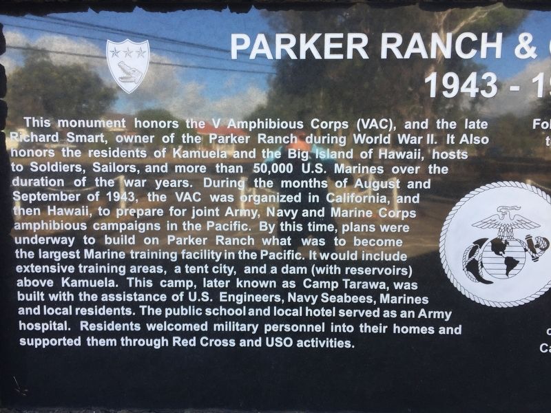
Parker Ranch & Camp Tarawa 1943-1945
This monument honors the V Amphibious Corps (VAC), and . . . — — Map (db m108940) HM WM
Near Akoni Pule Highway (Hawaii Route 270), on the left when traveling north.
Archaeologists seek to understand people and places of the past by studying the sites and cultural remains left behind. Students from the University of Hawai'i conducted extensive excavations here between 1968 and 1970 to learn about the people of . . . — — Map (db m110325) HM
Near Akoni Pule Highway (Hawaii Route 270), on the left when traveling north.
The ahupua'a is a traditional land division that runs mauka from the mountains to makai (seaward). The ahupua'a of Lapakahi encompasses more than 2,000 acres along the leeward slopes of the Kohala Mountains. The distance from the upland forests . . . — — Map (db m110324) HM
Near Kawaihae Road near Kawaihae Harbor Road, on the left when traveling north.
The submerged remains of Hale o Kapuni Heiau, a temple dedicated to shark akua (deities), are believed to lie just offshore. The heiau was built by a chief whose family revered sharks, believing that the family's 'aumākua (deified ancestors) . . . — — Map (db m110377) HM
On Daniel K. Inouye Highway (Saddle Road) (Route 200 at milepost 27) near Mauna Kea Access Road, on the left when traveling east.
Traditional native uses of the Humu'ula area included bird catching and, at much higher elevations, adze quarrying. They were replaced by sandalwood harvesting and hunting wild cattle, and ultimately ranching and astronomy. Over time, travelers . . . — — Map (db m110792) HM
On Daniel K. Inouye Highway (Saddle Road) (Hawaii Route 200 at milepost 28) at Mauna Kea Access Road, on the right when traveling east on Daniel K. Inouye Highway (Saddle Road).
Sheep raising became economically important within the interior of Hawai'i during the second half of the nineteenth century. In the 1860s, the Waimea Grazing and Agricultural Company established a station for sheep at Humu'ula. By 1873 it had a . . . — — Map (db m110787) HM
Near Kawaihae Road (Hawaii Route 270), on the left when traveling north.
The remains of Mailekini Heiau, a temple used before the time of Kamehameha, stand before you. Many mysteries surround Mailekini Heiau; its early history, kept orally and secretly within the priesthood, was never recorded. Historians agree that . . . — — Map (db m110367) HM
Near Kawaihae Road (Route 270), on the left when traveling north.
Who would suspect that the area at the base of this hill is one of the most significant cultural sites in Hawai'i? This plain-looking patch of earth was the site of Pelekane, one of several known royal compounds traditionally used by Hawaiian kings. . . . — — Map (db m110369) HM
On Daniel K. Inouye Highway (Saddle Road) (Route 200 at milepost 28) at Mauna Kea Access Road, on the right when traveling east on Daniel K. Inouye Highway (Saddle Road).
What is a kīpuka?
Pu'uhuluhulu, a 500-year old patter cone, is a kīpuka ( an older oasis within a newer lava flow). It preserves native plants and acts as a seed bank to revegetate the more recent lava flows that surround it. . . . — — Map (db m110790) HM
Near Kawaihae Road near Kawaihae Harbor (Hawaii Route 270), on the left when traveling north.
Build a heiau on Pu'ukoholā, the "hill of the whale," dedicate it to your war god, and you will achieve your dream - you will rule the islands. Responding to this prophecy told by Kapoykahi, a famous seer, Kamehameha built the . . . — — Map (db m110330) HM
Near Spencer Beach Park Road, 0.2 miles west of Kawaihae Road (Hawaii Route 270), on the right when traveling west.
Build a heiau on Pu'ukohola, the "hill of the whale," dedicate it to your war god, and you will achieve your dream — you will rule the islands. Responding to this prophecy told by Kapoukahi, a famous seer, Kamehameha built the heiau . . . — — Map (db m172849) HM
On Mamalahoa Highway (Hawaii Route 19) near Lindsey Road, on the left when traveling west.
With the first cattle arriving in the Hawaiian Islands in 1793 as gifts for King Kamehameha I, it was not long before they overpopulated and plundered the countryside from the mountains to the seashores. Determined to bring them under control and . . . — — Map (db m108949) HM
On Hawai'i Belt Road (Hawaii Route 19), on the right when traveling south.
This commemorative boot is symbolic of the 1908 victory of four Waimea paniolo who reigned as World Champion steer ropers in the Cheyenne Frontier Days Rodeo in Wyoming. — — Map (db m190123)
From 1959 through 1964
Regulus was the submarine
launched retaliatory
missile in the Pacific
The Regulus missile
deterrent strike force
operated from submarine
base, Pearl Harbor, under
the operational control of
Commander Submarine . . . — — Map (db m111762) WM
Launched 24 July 1943 (shield logo) Commissioned 20 November 1943
USS Parche SS-384
These men served aboard during her six war patrols
( 191 names)
* Wolf Pack Commander
** Commanding Officer of USS Parche
*** Lost at Sea- - 10 February . . . — — Map (db m111817) WM
This gun assembly consists of four recoil-operated, heavy machine guns, designed primarily for anti-aircraft fire. Each gun had a firing rate of 120 rounds per minute and fired a two lb. projectile. It had a maximum horizontal range of about 33,000 . . . — — Map (db m81385) WM
On Nuuanu Pali Drive, on the left when traveling north.
In the late 1700s, Kamehameha I from the island of Hawai’i, sought to unite all the Hawaiian islands under one rule. The battle for O’ahu began with the arrival of his forces at Waikiki in 1795.
O’ahu had been defeated by Maui forces a decade . . . — — Map (db m73557) HM
The Japanese raided Pearl Harbor and other military targets on Oahu with carrier-launched aircraft which included fighters, horizontal bombers, torpedo planes, and dive bombers. The planes struck here in two waves, beginning at 7:55 a.m., with a 15 . . . — — Map (db m226784) WM
More than two thousand Americans were killed on December 7, 1941, almost half of them aboard USS Arizona. Military installations around the island were attacked and nineteen ships were sunk, beached, or badly damaged. Hundreds of Navy and Army . . . — — Map (db m104804) HM
At dawn on 7 December 1941 more than half of the United States Pacific Fleet, approximately 150 vessels and service craft, lay at anchor on alongside piers in Pearl Harbor. All but one of the Pacific fleet’s battleships were in port that morning, . . . — — Map (db m71610) WM
He goes a great voyage that goes to the bottom of the sea, George Herbert, Jacula Prudentum, 1651
Throughout the history of submarine development, men have fought enemies just as lethal as any human foe. Those who brave the deep in . . . — — Map (db m81389) HM WM
This was the U.S. Navy's primary torpedo in WWII. When fired, compressed air, alcohol and water were mixed and ignited in the combustion chamber to produce the steam that powered the turbines.
Weight-3,200 lbs.; Length-20.5 feet; Diameter-21 . . . — — Map (db m81384) HM
This high-performance, submarine-launched weapon is considered to be the first successful torpedo developed for use against other submarines. The Mark 37 was designed to swim out of a 21-inch torpedo tube, to which it remained attached by a length . . . — — Map (db m81388) HM
On Nuuanu Pali Drive north of Pali Highway (Hawaii Route 61), on the right when traveling north.
An International Soaring Record was established here on December 18, 1931. William A. Cocke Jr. remained aloft in a glider called the Nighthawk for 21 hours 34 minutes, a new U.S. and world endurance record for motorless fight.
Cocke’s . . . — — Map (db m156376) HM
On Nuuanu Pali Drive, on the left when traveling north.
Constructed in 1897 and opened for the public traffic in 1898. The road has an average grade of eight percent and is 8800 feet long. The original survey was made by John H. Wilson under supervision of William E. Rowell Superintendent of Public . . . — — Map (db m73555) HM
On Nuuanu Pali Drive, on the right when traveling north.
In the early 1800s, you had two choices if you wanted to travel between Honolulu and Windward O’ahu.
You could take a canoe trip around the southern end of the island or hike over the steep cliffs of the Ko’olau mountains. The pali (cliff) . . . — — Map (db m73554) HM
From this viewpoint along the eastern shore of Pearl Harbor you can see many features associated with the 1941 Japanese attack. The photo was taken in 1991, fifty years after the bombing.
1. Attack Signal-From the cockpit of his bomber over the . . . — — Map (db m71620) WM
From this viewpoint along the eastern shore of Pearl Harbor you can see many features associated with the 1941 Japanese attack. The photo was taken in 1991, fifty years after the bombing.
1. Naval Station Signal Tower-From the top of this water . . . — — Map (db m71619) WM
December 7, 1941, at Pearl Harbor began routinely. Sailors and marines turned out for church services, morning colors, and chow. They looked forward to off-duty time for recreation, letter-writing, or sleep. It was Sunday in the peacetime Navy. . . . — — Map (db m71617) WM
The base of
this statue
contains steel
from the USS Arizona
with appreciation to the following supporters
(list of 16 donors)
Stanley Bleifield, sculptor
The Lone Sailor® is the iconic image of
The United States Navy . . . — — Map (db m111210) WM
Step aboard and dive into submarine history onboard USS Bowfin (SS-287). A restored World War II submarine nick-named the "Pearl Harbor Avenger". Launched December 7, 1942, she made 9 successful war patrols in the Pacific, sinking 44 enemy ships. — — Map (db m81377) HM
United States Marines
Pearl Harbor
dedicated 10 November 2005
to Lt Colonel D R Fox
and the eighty seven men of the
Marine Detachment onboard
the USS Arizona
7 December 1941 at 0755
Born 10 July 1898
Died 7 December 1941
KIA . . . — — Map (db m111672) HM WM
This anchor was recovered from the Arizona
The ship had three anchors. The crew used one
in calm seas, two during foul weather, and the
third as a spare. Each weighs nearly ten tons.
Notice the size of the anchors compared to
the . . . — — Map (db m111209) WM
LCDR A.M. Bontier, USN, Commanding Officer; Launched 15 August 1939; Lost at Sea, 3 October 1944.
Beginning with her first patrol just hours after the Japanese attack on Pearl Harbor, a daring submarine embarked on a career that made the name . . . — — Map (db m81417) WM
CDR K.E. Montross, USN, Commanding Officer; Launched 1 April 1939; Lost at sea, January 1945.
Less than two weeks after the Japanese attack on Pearl Harbor, Swordfish sank her first ship. So began the career of a submarine that not only sank . . . — — Map (db m81419) HM WM
CDR R.H. Kane, USN, Commanding Officer; Launched 17 August 1943; Lost at sea, 24 October 1944.
The exploits of Tang are legendary in submarine history. Under the bold leadership of Commander Richard H. O’Kane, Tang executed five brilliant . . . — — Map (db m81473) HM WM
CDR D.W. Morton, USN Commanding Officer; Launched 14 February 1942; Lost at sea 11 October 1943.
If one submarine could be said to embody the spirit and pride of the U.S. Submarine Force, it would probably be Wahoo. Certainly the enemy . . . — — Map (db m81474) WM
On Kalahaua AVenue south of Kapiolani Boulevard, on the right.
Ala Wai (freshwater way) Canal was
at the heart of the Waikīkī Reclamation Project launched in the early 1900s “to
reclaim an unsanitary and most unsightly portion of the city.” The duck farms and the millions of mosquitoes . . . — — Map (db m13196) HM
On South King Street north of Punchbowl Street, on the right when traveling south.
King Kamehameha I (c. 1758–1819) is generally recognized as the most important figure in Hawaiian history. He was a wise ruler who enacted laws to protect the defenseless and to bring order to the newly united kingdom. An astute statesman, he . . . — — Map (db m13581) HM
On South King Street north of Punchbowl Street, on the right when traveling south.
Originally designed as a palace, it was built by Kamehameha V to house the legislature, courts and cabinet offices of the Kingdom. He died not long after laying the cornerstone and the building was given his name Aliiolani. It was formally opened by . . . — — Map (db m13569) HM
On South Beretania Street north of Punchbowl Street, on the left when traveling north.
Greater love has no man than this, that a man lay down his life for his friends. —John 15:13
Born a farmer’s son at Tremeloo, Belgium, January 3, 1840. Damien joined the Missionary Congregation of the Sacred Heart and was ordained a . . . — — Map (db m13485) HM
On South King Street south of Kawaiahao Street, on the right when traveling south.
In a grass house near this site High Chief Keeaumoku pulled the first sheet in the presence of Elisha Loomis, Printer; the Reverend Hiram Bingham; and James Hunnewell, Mission benefactor. — — Map (db m60945) HM
On Punchbowl Street at South King Street, on the left when traveling south on Punchbowl Street.
A Centennial Memorial of Hiram Bingham. Born in Bennington, Vt., Oct. 30, 1789. Died in New Haven, Ct., Nov. 11, 1869, Aged 80 Years.
This slab is placed here in grateful remembrance of a pioneer Missionary by descendants of Hawaiians . . . — — Map (db m13800) HM
On South King Street, on the right when traveling south.
'Iolani Palace is a living restoration of the offical royal residence for the Kalakaua Dynasty that ruled the Kingdom of Hawai'i from 1874 to 1893. King Kalakaua, who resigned for 17 years, built the palace in 1882 as a symbol of Hawaii's civilized . . . — — Map (db m74148) HM
On Punchbowl Street at South King Street, on the left when traveling south on Punchbowl Street.
William Charles Lunalilo was the kingdom’s sixth
monarch and proved to be very popular from the
beginning of his reign. King Kamehameha V had
preceded Lunalilo and had died without naming a successor. Therefore Lunalilo was appointed by the . . . — — Map (db m13809) HM
On Punchbowl Street, on the left when traveling east.
Built of gaint coral slabs, hewn from ocean reefs, this sanctuary became known as The Stone Church.
This structure was preceded by a succession of four thatched grass buildings which served as houses of worship until ground was broken in 1837. . . . — — Map (db m74145) HM
On Punchbowl Street, on the left when traveling east.
In the middle of an otherwise dry and barren plane, existed a sacred spring on these grounds, reserved for use by high chiefs and chiefesses only. Legend tells us that among the high ranking who enjoyed the privilege of bathing in the large circular . . . — — Map (db m74144) HM
On Punchbowl Street at South King Street, on the left when traveling south on Punchbowl Street.
King Kamehameha V died on December 11, 1872, without naming a successor to the throne. Prince William Charles Lunalilo was the highest ranking Chief at that time. Instead of claiming his birthright to the throne, he wanted the people to choose their . . . — — Map (db m13788) HM
On Punchbowl Street, on the left when traveling east.
Born in 1824 at Mokuleia Oahu
Educated by James Hunnewell at Lahainaluna
First Hawaiian Christian Minister
Ordained at Kahuku December 21 1849
In 1853 he went as a pioneer missionary to
the Marquesas . . . — — Map (db m74147) HM
On Diamond Head Rd, on the right when traveling east.
The Hawaiian goddess Hi’iaka compared the
peak of volcanic cone of Diamond Head to the
dorsal fin of the ‘ahi fish, thus the Hawaiian name
for Diamond Head is Le’ahi.
This site was once the Dillingham Home, the
beachfront house of Harold . . . — — Map (db m111326) HM
On Cowpens Street, on the left when traveling north.
He was aggressive in war without hate; he never forgot that he was dealing with human beings, on both sides of the conflict. (E.R. Potter, 1976)
Born to Frederickburg, Texas in 1885, Chester W. Nimitz was accepted into the United States naval . . . — — Map (db m73127) HM
The Navy’s Retention Excellence Award, or “Golden Anchor” is
traditionally awarded to active-service Naval vessels for meeting or
exceeding crew retention goals.
On June 11, 2005, Battleship Missouri became the first non-active . . . — — Map (db m112231) HM
This memorial honors the fallen crew of USS Arizona and all those who died in the attack on December 7, 1941. The remains of over 900 Arizona crewman rest beneath you within the sunken battleship. Just ahead is an open area where you . . . — — Map (db m73230) HM WM
U.S. Naval Base, Pearl Harbor
has been designated a
Registered National
Historic Landmark
Under the provisions of the
Historic Sites Act of August 21, 1935
this site possesses exceptional value
in commemorating and . . . — — Map (db m4526) HM
On Langley Avenue, on the right when traveling north.
At 0755, 7 December 1941,
near this spot at Berth Fox 7
The USS Arizona
was hit by one torpedo and approximately
seven bombs. One bomb went down the stack and another penetrated the black powder magazines. The sunken ship remains the tomb . . . — — Map (db m143290) HM WM
“…In honor, and in commemoration of the
members of the armed forces of the United
States who gave their lives to their
country during the attack on Pearl
Harbor, Hawaii on December 7, 1941.”
Public Law 87-201
Construction . . . — — Map (db m111524) HM WM
On Langley Avenue, on the right when traveling north.
In reverent recognition of divine guidance
and - to the eternal memory of those who
gave their last full measure of devotion
to their country this monument is
dedicated - humbly to their sacrifice in
defending our freedom.
Erected by the . . . — — Map (db m60157) HM
On Saratoga Boulevard north of Yorktown Boulevard, on the right when traveling east.
Near this spot, at Berth Fox 11
on the morning of 7 December 1941,
the USS Utah was struck on the portside
with what is believed to have been
three aerial torpedoes and was sunk.
She was subsequently rolled over
to clear the channel but . . . — — Map (db m60044) HM
On Saratoga Boulevard, on the right when traveling west.
This memorial was officially authorized by the 91st Congress of the United States of America on 14 October 1970. Its construction was made possible by Congressional appropriation and by the generous contributions of many individuals and . . . — — Map (db m60071) HM
In the waters ahead lie the mostly submerged remains of USS Utah, a former battleship used for target and gunnery training. Two torpedoes struck the Utah as the Pearl Harbor attack began on December 7, 1941. The ship capsized, trapping . . . — — Map (db m60161) HM
At 0758, 7 December 1941,
near this spot at Bert Fox 6
the USS West Virginia
moored outboard the USS Tennessee
was damaged and sunk by enemy bombs and torpedoes.
As the West Virginia settled to the bottom
she forced the Tennessee against the . . . — — Map (db m60158) HM
In these gardens are recorded
the names of Americans
who gave their lives
in the Service of their Country
and whose earthly resting place
is known only to God
*Indicates Medal Of Honor Award — — Map (db m4504) WM
On Diamond Head Rd, on the right when traveling north.
The Diamond Head Lighthouse is a prominent symbol of Hawaiian
history to residents and visitors alike.
The lighthouse rests aside a tuff-cone volcano, formed by
explosive eruptions thousands of years ago.
In 1825, British sailors ascended the . . . — — Map (db m111324) HM
On Diamond Head Rd at 18th Avenue, on the right when traveling north on Diamond Head Rd.
Millennium Peace Garden
This garden was planted on October 24, 1999 by 750
youth from 103 countries during the Millenium Young
Peoples Congress. It demonstrates the principles of
environmental sustainability and world peace.
dedicated January . . . — — Map (db m112023) HM
On this site stood the villa of Chun Afong, Hawai‘i’s first Chinese millionaire, who arrived
in Honolulu in 1849. By 1855, he had made his fortune in retailing, real estate, sugar and rice, and for a long time held the government monopoly opium . . . — — Map (db m49676) HM
Olympic swimming champion Duke Kahanamoku (1890–1986) spent much of his youth here in Kālia with his mother’s family, the Paoas. The family owned most of the 20 acres which the Hilton Hawaiian Village now occupies.
It is said that it was . . . — — Map (db m13188) HM
On Kalakaua Avenue, on the left when traveling west.
Raised in Waikiki, Duke was a full blooded Hawaiian, who symbolized Hawai'i to millions of people. He developed into an Olympic Champion and the world's fastest swimmer. Between 1912 and 1932 he won three gold medals, two silver and a bronze in four . . . — — Map (db m73257) HM
On Ala Moana Boulevard at Kalakaua Avenue and Pau Street, on the right when traveling west on Ala Moana Boulevard.
This green expanse in the middle of Waikīkī is Fort DeRussy, named in honor of Brigadier General Rene E. DeRussy, Corps of Engineers, who
served with distinction in the American—British War of 1812. It was started in 1908
as vital . . . — — Map (db m13219) HM
Surrounded by this open landscape, one can imagine the huge coconut grove known as Helumoa. Planted by Chief Kakuhihewa around the 15th century, the grove once had nearly 10,000 trees. Kahuamokomoki was an area nearby that served as a sporting . . . — — Map (db m73416) HM
Operated by a crew of three protected by only 1/2 inch of armor and equipped with one 37mm gun and two 7.7mm machine guns. It was powered by a 6-cylinder, 110 H.P. air-cooled diesel engine with a range of 90-100 miles at speeds up to 30 MPH. — — Map (db m82123) WM
A light-weight mobile piece used by independent antitank and armored units. Its 3 lb. shell could penetrate 3 inches of armor at 500 yards. — — Map (db m82127) WM
Near Holomoana Street south of Ala Moana Boulevard.
Fish were easily netted from the ponds near Pi‘inaio Stream.
In ancient times, the
area was home to many Hawaiian families, who enjoyed the offerings in its bountiful waters. It was not unusual to see native men and women fishing, . . . — — Map (db m13127) HM
On Ala Moana Boulevard (Hawaii Route 92) at Kalia Road, on the right on Ala Moana Boulevard.
Envisioned on a grand scale, these three awe-inspiring figures in bronze are dancing hula kahiko, the ancient style of Hawaiian dance. The two female dancers, spirits of the wind, represent the dance and chant of Hawaiian hula. . . . — — Map (db m71922) HM
Had you walked across this road in 1897 you might have landed in Waikĩkĩ’s largest fishpond, the Ka’ihikapu, which measured 13 acres. All of today’s Fort DeRussy on the mauka (toward the mountain) side of the road was covered with . . . — — Map (db m73113) HM
From olden times Waikīkī was viewed not only as a place of peace and hospitality, but of healing.
There was great mana (spiritual power) in Waikīkī. Powerful kahuna la‘au lapa‘au (or physicians) lived here. Throughout the . . . — — Map (db m13225) HM
On Kalia Road at Maluhia Road, on the left when traveling south on Kalia Road.
Named in honor of Staff Sergeant Robert T. Kuroda, 442nd Regimental Combat Team.
On 20 October 1944, during the battle of Bruyeres, France, Sergeant Kuroda led his squad in an attack against a strongly defended enemy position. He deployed . . . — — Map (db m13256) HM
This cannon was one of a battery of twelve guns placed on punchbowl crater by the Hawaiian monarchy beginning in 1831. Both to defend Honolulu Harbor and to fire salutes. The U.S. Army moved the cannon to Bishop Museum in 1920, where it remained . . . — — Map (db m82128) HM
On Kalakaua Avenue, on the left when traveling west.
Prince Jonah Kuhio Kalaniana’ole, the son of High Chiefess Kekaulike Kinoiki II and High Chief David Kahalepouli Pi’ikoi, was born on March 26, 1871 at Ho’ai, Kaua’i. His mother died soon after his birth and he and his two older brothers were hanai . . . — — Map (db m73117) HM
Near Ala Moana Boulevard (Hawaii Route 92) at Kalia Road.
This Rainbow Mural, tallest in the world, 286 feet high, 26 feet wide, comprises 8,046 pieces of hand-painted ceramic tile created for the Hilton Tower by Millard Sheets. Dedicated by Conrad N. Hilton and Fritz B. Burns. November 8, 1968. — — Map (db m19077) HM
Near Holomoana Street south of Ala Moana Boulevard.
The legendary surfer Duke Kahanamoku often strolled the sands of Waikīkī Beach fronting what is now Hilton Hawaiian Village Beach Resort & Spa, 1959.
In ancient times, the coastal plain where you now stand was known as . . . — — Map (db m13082) HM
On Kalaukaua Ave, on the left when traveling west.
Princess Lili’uokalani enjoyed spending time with Robert Louis Stevenson on Waikiki in “earnest conversation”, Feb 3, 1889
This section of Waikiki Beach contains four distinct areas: Outrigger Canoe Club, San Souci, Kapi’olani Park and Queen’s . . . — — Map (db m73122) HM
On Kalakaua Avenue, on the right when traveling north.
The Moana Hotel opened on March 11, 1901 as Waikiki’s first hotel. Affectionately called “The First Lady of Waikiki,” this iconic resort embraces true Hawaiian hospitality. Walter Chamberlain Peacock, the original owner of the Moana . . . — — Map (db m73114) HM
On Kalaukaua Ave, on the left when traveling west.
Legend says these stones are the living legacy of four powerful Tahitian healers who once resided near this site at a place called Ulukon. From the court of the Tahitian chief, the names of the four were Kapaemahu, Kapuani, Kinohi, and Kahaloa. . . . — — Map (db m73116) HM
On Ala Moana Boulevard (Hawaii Route 92) at Kalia Road, on the right on Ala Moana Boulevard.
Chief Ma‘likūkāhi, who reigned over the island of Oahu in the mid-1400s, resided in Waikīkī and used it as his seat of government. He was greatly loved by his subjects who enjoyed unprecedented peace and prosperity. Ali‘i . . . — — Map (db m13200) HM
With the emergence of airborne troops in 1941 came the need for an airborne howitzer. The M3 was created by shortening an existing 105mm howitzer barrel and mounting it on a modified 75mm carriage. The lightweight M3 proved to be an effective weapon . . . — — Map (db m82125) WM
Used for scouting and reconnaissance in the late days of WWII. It mounted a 75mm main gun and three machine guns behind 1" of armor. Two Cadillac V-8 engines drove the 19 ton tank and its crew of four at speeds up to 35 MPH. — — Map (db m82124) WM
In the months before Dec 7th, many of these steel pillboxes were planted to defend military installations, airfields, and likely landing beaches around Oahu. Once buried in position, the 2-man crew entered through culvert pipe openings at the base . . . — — Map (db m82121) WM
Born to Chiefess Miriam Kapili Likelike (sister to King Kalākaua and Queen Lili’uokalani) and Governor Archibald Scott Cleghorn. She was the only child born to the last ruling dynasty of the Hawaiian Kingdom.
Princess Ka’iulani and her . . . — — Map (db m73229) HM
On Kalaukaua Ave, on the left when traveling west.
Waikiki means “spouting water” because it was a vast marshland fed by many streams. You are in fact standing on what was the mouth of an old stream, the Kuekaunahi. From ancient times Waikiki has been a popular surfing spot which is one of the . . . — — Map (db m73119) HM
Near Kuilima Drive, 0.5 miles north of Hawaii Route 83, on the left when traveling north.
On December 7, 1941, an SCR-270B Radar located
at this site tracked incoming Japanese aircraft
for over 30 minutes until they were obscured
by the island ground clutter. This was the first
wartime use of radar by the United States Military,
and . . . — — Map (db m154431) HM WM
Near Kuilima Drive, 0.5 miles north of Hawaii Route 83, on the left when traveling north.
Mobile Radar Unit SR-270B
has been designed a
National Historic Landmark.
This site possesses national significance
in commemorating the history of the
United States of America. — — Map (db m154432) HM
On G Street (Intrastate H 3 ), on the left when traveling north.
“It will all happen in a moment,
in the twinkling of an eye. When the
last trumpet is blown.
When this happens, then at last
this scripture will come true-
Death is swallowed up in Victory.”
I Corinthians 15:52 and 54
This . . . — — Map (db m111960) HM WM
While travelling around the world on an assignment to visit the
foreign missions of The Church of Jesus Christ of the Latter-day Saints,
Elder David O. McKay, a member of the Quorum of the Twelve Apostles, and
Hugh J. Cannon visited Hawaii in . . . — — Map (db m111520) HM
This is the site of the LDS Hawaii Mission School
where President David O. McKay, then member of
the Church’s Quorum of the Twelve Apostles,
witnessed a flag raising ceremony on February 7, 1921.
Observing the multi-ethnic student body . . . — — Map (db m111519) HM
Near Kamehameha Highway (Hawaii Route 99) 0.8 miles south of Ford Island Boulevard.
The instrument of surrender terminating the Second World War was signed on this ship, 2 September 1945 east longitude date while she lay at anchor in Tokyo Bay.
The Allied representatives were • General of the Army Douglas MacArthur, The . . . — — Map (db m49677) HM
The discipline which makes the soldiers of a free country reliable in battle is not to be gained by harsh or tyrannical treatment—on the contrary—such treatment is far more likely to destroy than to make an army. It is possible to impart . . . — — Map (db m81310) HM
In the spring of 1951, units of the 25th Infantry Division crossed the Han River to liberate the City of Seoul. One of the units that took part in this operation was C Company, 89th Tank Battalion. In preparation for their assault across the Han, . . . — — Map (db m81311) HM WM