Milford and Martha (Mattie) Shirley Givens pulled up Missouri roots and headed west in 1878, apparently bound for Portland, Oregon where relatives were settled. Their journey eventually led them along the South Alternative Route of the Oregon Trail. . . . — — Map (db m47134) HM
Natural hot water available here
has been a popular attraction
for thousands of years.
A winter village site for about 5000 years, these hot springs had large pit houses typical of plateau communities northwest of here from 4,300 to about . . . — — Map (db m47336) HM
On August 20, 1854, the Alexander Ward Party of 20 men, women, and children were traveling on the Oregon Trail with five wagons, a day behind a larger party led by Alexander Yantis. The Wards pulled their wagons off the Trail for lunch and to water . . . — — Map (db m22398) HM
In the 1830's, local tribes, including the Shoshone, Paiute, and Bannock began trading with Euro-American fur trappers and missionaries passing through southern Idaho. Peaceful exchanges beneficial to both groups increased in 1842 when wagon trains . . . — — Map (db m22333) HM
Only 2 young boys survived the Indian attack on Alexander Ward's 20 member party, Oregon bound on August 20, 1854. Military retaliation for the slaughter so enraged the Indians that Hudson's Bay Co. posts Fort Boise and Fort Hall had to be . . . — — Map (db m22328) HM
To the memory of the pioneers who were massacred by Indians near this spot August 20, 1854.
This monument is dedicated by Pioneer Chapter
Daughters of the American Revolution Boise, Idaho
William Ward Age 44
Margaret Ward " . . . — — Map (db m22336) HM
In early September, 1854, Major Granville Hallar set out with a US military force from their post in Oregon to avenge the Ward-party deaths. Upon arrival at the rebuilt Hudson Bay's Fort Boise near the mouth of the Boise River, the Indians they . . . — — Map (db m22366) HM
Confederate refugees from Missouri started farming in this area in 1863 and 1864, when gold and silver mining camps created a great demand for flour and cattle. Driven out from their Missouri River homes below Kansas City by extremely bitter Civil . . . — — Map (db m21988) HM
An important Hudson's Bay Company fur trade post was established in 1834 four miles west of here on the bank of the Snake River. Fur trading declined, but this British post became famous for its hospitality to American travellers on the Oregon . . . — — Map (db m21992) HM
In 1879, Mormon farmers from Utah settled Chesterfield, 16 miles north of here.
Based on Joseph Smith's Zion Plat, Chesterfield was laid out on an orderly grid of large blocks separated by wide streets with the Meeting House on the highest . . . — — Map (db m106773) HM
Mormon pioneers settled this area along the Oregon Trail in the 1880s. The town was named Chesterfield because it reminded some of the countryside around Chesterfield, England, and to honor the settlement's founder, Chester Call.
A traditional . . . — — Map (db m124578) HM
In the summer of 1849, the California Gold Rush was diverted this way in search of a more direct route to the mines.
Stampeding 49'ers would try anything to save miles and time in their rush for California's gold: the regular Oregon and . . . — — Map (db m106774) HM
After the arrival of the first settlers of Chesterfield in 1875, covered wagon trains continued to use the Old Oregon Traill of 1846 which passed this point. Tired discouraged and ill, travelers arrived here from early spring to late autumn. Local . . . — — Map (db m124580) HM
The Oregon Trail was not blazed by the first wagon train of emigrants who set out on the journey in 1841. They were following pathways discovered and described by explorers, and mountain men in the early 1800s - pathways traveled for countless years . . . — — Map (db m124650) HM
In 1880, several Latter-Day Saint families settled in this valley of the Portneuf, naming the area Chesterfield. Nov. 27, 1883, a branch of the Church was organized with Judson A. Tolman presiding Elder. Labor was donated, lumber came from nearby . . . — — Map (db m124581) HM
The Bidwell-Bartleson Party
In 1841, John Bidwell and John Bartleson became the first Americans emigrants to undertake a wagon crossing from Missouri to California.
Although Oregon was the primary destination of early westward-bound . . . — — Map (db m140278) HM
Founded by a Dutch pioneer about 1884, Henry thrived as a center for cattle ranchers of the area and the transient sheep operators.
A large sheep-shearing corral was built one mile south of Henry.
It operated about 60 days each year as large . . . — — Map (db m109951) HM
The first Mormon emigrants arrived in the Salt Lake Valley in 1847 and immediately began laying the groundwork for the small settlement that would become Salt Lake City. Church President Brigham Young however, had a much grander vision for his . . . — — Map (db m35469) HM
Claiming to have received "revelations" to warn Mormon leader Brigham Young that he was "wandering from the right course," a Welshman named Joseph Morris came under rebuke in 1862 for speaking out against Mormon doctrines. Growing hostilities . . . — — Map (db m106709) HM
On this site in 1870, the first house in Soda Springs, Uppertown was built under the direction of John Walmsley. It was a one room log cabin twenty-two by eighteen feet, with floor, windows, and shingle roof, known as the Brigham Young Summer Home. . . . — — Map (db m35466) HM
The magnet of gold
In 1870, high in the remote Caribou Range of the middle Rocky Mountains, in southeastern Idaho, gold was discovered by intrepid gold-seekers. Tales of gold and wealth drew thousands to the West during the mid-19th century . . . — — Map (db m106213) HM
Floods of emigrants, gold seekers, and Mormon settlers entering the homeland of the Shoshone and Bannock people from the mid-1840s to early 1860s gave rise to conflict and often violent encounters. Despite Mormon effort to supply them with food, . . . — — Map (db m106723) HM
In many respects, emigrants Niels Anderson and Mary Christoffersen seem like typical young Idaho pioneers of the 1860s. Niels, 28 years old, and Mary, barely 16, were wed by a Justice of the Peace at an open-air ceremony at Camp Connor on July 30, . . . — — Map (db m106726) HM
For over two decades (1834-1856), fur trappers and Oregon Trail wagon trains passed by the doors of this adobe fort. Nathaniel Wyeth, an ambitious Bostonian, built the post in 1834 but soon sold his holdings to the Hudson's Bay Company, whose staff . . . — — Map (db m106849) HM
U.S.A. Cavalry Infantry
53 families and others
Founded Soda Springs
Built fort to protect emigrants
County seat Oneida County
1864 ---- 1867 — — Map (db m124492) HM
George and Leah were parents of eleven children. In early November, 1884 George and Leah lost four of their five young daughters, in a two week period, to a terrible diphtheria epidemic. Leah did not like the Pioneer Cemetery east of town because of . . . — — Map (db m106633) HM
Native Americans traveled and camped in the Soda Springs area for centuries before emigrants traveled the Oregon Trail.
Sheep Rock (Soda Point) marked the junction of the main route of the Oregon-California Trail and the Hudspeth Cutoff and was . . . — — Map (db m106850) HM
Westward-bound emigrants entered Idaho after crossing Thomas Fork Valley. They soon encountered the climb and decent of Big Hill, witnessed nature's curiosities at Soda Springs, and discovered willing traders at Fort Hall.
In 1843 wagons first . . . — — Map (db m106845) HM
In 1840, John Bidwell began to assemble emigrants from Missouri to open a road to California; and a year later, he set out with a party of 69 Pacific Coast pioneers.
When they reached here, August 12, 1841, half of this group decided to go . . . — — Map (db m106729) HM
Excitement and anxiety mounted as emigrants prepared to launch their ox-drawn prairie schooners from St. Joseph and Independence, Missouri - bustling river ports at the edge of the frontier in the 1840s. To them, the great, gray ribbon of the . . . — — Map (db m106710) HM
Only memories remain...
In 1920, the ambitious Anaconda Copper Mining Company built the community of Conda to house its phosphate miners and their families. About 300 people resided in Conda during the mining heyday. The town closed in . . . — — Map (db m106695) HM
The story of the American West is not simply a tale of pioneer courage and vision or of prairie schooners swaying westward to the strains of heroic music. Rather, it is a complex story of plots and sub plots, of romance and religion, of politics and . . . — — Map (db m106255) HM
In this area are a group of springs famous to Oregon Trail travelers, most of whom stopped to try the "acid taste and effervessing gasses" of the waters.
Earlier, fur traders often -- less elegantly -- called the place "Beer Springs" after . . . — — Map (db m105967) HM
(left panel:)
Tour Our National Byways
Click on the Tour Our National Byways photograph to enlarge it and view the local byway routes. (center panel:)
The springs of Soda Springs - indeed a . . . — — Map (db m106214) HM
When they left the main trail leading to Fort Hall, emigrants heading to California thought that Hudspeth's Cutoff would save them considerable time and miles in the race to the gold fields. To their surprise, they were still in Idaho's Raft River . . . — — Map (db m106772) HM
This monument marks the grave of an immigrant family, father, mother , and five children, massacred on Little Spring Creek one half mile south of this spot, buried in their own wagon box by trappers and immigrants led by George W. Goodheart. — — Map (db m106254) HM
Oregon Trail Memorial
Erected 1931
Restored 1978
Caribou County 4H Builders Club
In honor of William Henry Harrison of Massachusetts who lost his life on the Oregon Trail about 1850.
Erected by his niece Mrs. Alura F. . . . — — Map (db m106732) HM
(left panel:)
Settling Grays Lake Valley
With determination and spirit
Cattle, sheep and crops
At first cattlemen found the luxurious waist-high grass of Grays Lake Valley perfect for raising cattle. The . . . — — Map (db m106160) HM
Surrounded by high Rocky and very ragged looking mountains -- this valley we take the liberty to call Pleasant Valley, as it is a very good and pleasant for camping. -- Leander V. Loomis, circa 1850, describing the Circle Creek Basin. . . . — — Map (db m123961) HM
"At the entrance of the pass was a pleasant little spring & fine branch." - Wakeman Bryarly, Jul 20, 1849
Guidebook available
Trails West Inc, P.O. Box 12045 Reno NV 89510 — — Map (db m138456) HM
"We enter a gorge of the hills which in a short time brings us to a large ampitheatre surrounded with rock of every kind of fanciful character." -- Joseph Middleton Aug 26, 1849 Guidebook Available
Trails West Inc. P.O. Box 12045, Reno . . . — — Map (db m123955) HM
"A ride ... brought us to the outlet of this romantic vale, a very narrow pass - just wide enough for a wagon, and on either side very high, jagged and thin walls of granite ... called the 'Pinnacle Pass'" - J.G. Bruff, Aug 29, 1849
. . . — — Map (db m123990) HM
"The gray granit rocks stand in pyramid monument & dome forms., here & there towering aloft. The road winds along between them. Emigrants names are written ... on these curious structures" -- Augustus Ripley Burbank, Aug 4, 1849 Guidebook . . . — — Map (db m123987) HM
...with a wide plain at our left and high mountains at our right and being within sight of the...Salt Lake Route which road intersects our trail seven miles further on. - Emigrant journal entry (Lewis), circa 1850, describing their camp . . . — — Map (db m123953) HM
There are thousands of names here I registered on a large Rock. -- Richard Augustus Keen at City of Rocks, June 22, 1852
Throughout the West emigrants recorded their passing by writing their names -- often with axle grease -- at unique . . . — — Map (db m123960) HM
After dinner a ride of 2 miles brought us to the outlet of this romantic vale, a very narrow pass, just wide enough for a wagon, and on either side very high, jagged. and thin walls of granite.... This is called the "Pinnacle Pass." -- J. . . . — — Map (db m123988) HM
"The Oregon road take up the bluff and follows the course of the (Snake) river while we keep to the left and follow the creek (Raft River) nearly to its source. ... crossing the creek we followed up the bottom" -- Byron McKinstry, Aug 1, 1850 . . . — — Map (db m123844) HM
"Arrived at Raft River, crossed and nooned. ... traveled five miles up Raft River and camped after recrossing it. Grass in abundance and plenty of wood" -- Cyrus Loveland, Aug 3 1850
Guidebook Available
Trails West Inc. P.O. Box 12045, . . . — — Map (db m123846) HM
"We traveled up Raft River 16 miles. The road, water and grass, good. Entirely destitute of timber, except a little willow on the streams and the wild sage." -- Chester Ingersoll, Aug 13, 1847
Guidebook Available
Trails West Inc. P.O. . . . — — Map (db m123848) HM
After wheat crops flourished in the dry farm area, Idahome sprang up here in 1916 as a railroad terminal. Irrigation projects boosted its Economy.
When wheat farms disappeared and highway traffic replaced rail service here, Idahome became . . . — — Map (db m123849) HM
In 1811 the first white expedition to go through this area of the Snake River and the lower end of the Raft River Valley was the Wilson Price Hunt expedition from St. Louis to Astoria. However, the area was well known to the French and British . . . — — Map (db m123843) HM
"August 26, Sabbath."
"... We got a late start traveled directly across the valley before us, (Almo Valley) amidst the best scenery we have seen since we have been among these hills. South, a high range of mountains (Raft River Mountains) . . . — — Map (db m123884) HM
"After crossing (Cassia Creek) we crossed a swamp, which required considerable persevering to get through safely. Three miles farther we encamped on the side of a hill, between two ranges of mountains" -- Wakeman Bryarly, Jul 18, 1849
. . . — — Map (db m123883) HM
"By an easy ascent reached a summit and as gradually descended to a valley (Upper Raft River Valley) of sage and sand sloping to the south east. The streams running towards the (Great) Salt Lake." Byron N. McKinstry, Aug 3, 1850
Guidebook . . . — — Map (db m123886) HM
"We came onto the Subetts Cut Off road (Hudspeth Cutoff), or rather that cut off come onto our road which is the old and longest road." -- Henry Anable, Aug 7, 1852
Guidebook Available
Trails West Inc. P.O. Box 12045, Reno NV . . . — — Map (db m123882) HM
This shortcut to the California goldfields, followed by most of the 49'ers, came out of the hills to the east and joined the old California trail just about here. Opened by "Messrs. Hudspeth & Myers, of the Jackson County, Missouri, Company," who . . . — — Map (db m31638) HM
The Raft River Valley was used by Native Americans as a place to hunt and winter because the snow didn't lie in the valley and there was good water and plenty of grass for the animals. British and American trappers, Peter Skene Ogden, Milton . . . — — Map (db m123881) HM
"The moon just rising above the mountains, throwing mild light over the valley & opposite mountain, formed a beautiful scene of prairie mountain life." -- Hugh Brown Heiskell, Sep 3, 1849
Guidebook Available
Trails West Inc. P.O. Box . . . — — Map (db m124026) HM
A vast display of towering granite rocks (16 miles southeast of here) attracted emigrants who were on their way to California. A gold rush visitor, July 14, 1849, reported that "you can imagine among these massive piles, church domes, spires, . . . — — Map (db m31637) HM
Indians have lived here next to this good fishing hold for 10,000 years.
As long as 3,000 years ago, they had large oval houses, 28 feet long by 24 feet wide. To build these houses, they put a bark and mat covering over a frame of 50 or so . . . — — Map (db m121416) HM
Founded by Seth S. Slater, May 6, 1861, Slaterville (permanent population, 50) had 5 edifices – built mainly of colored blankets – 2 stores, 2 houses, and a saloon.
When the Colonel Wright “snapped her tow-line on the Grand Rapids . . . — — Map (db m110703) HM
David Fraser, a young merchant, came to the area with a pack string headed for Pierce City, the gold rush area, to open a store in the Spring of 1863. Some people of the area encouraged Fraser to open the store here as a lot of the miners had moved . . . — — Map (db m121417) HM
Low mounds and depression in the ground here give only the faintest impression of villages that stood on both banks of the river. These are the remains of pit houses, built 1,500 to 2,000 years ago. Imagine the scene then: people spearing fish, . . . — — Map (db m109876) HM
The fabulous Gold Rush days of Idaho began on September 30, 1860, when W.F. Bassett struck gold just about here.
E.D. Pierce, who knew the country, had led twelve prospectors, including Bassett, out from Walla Walla in August. After news of . . . — — Map (db m121518) HM
Commercial center of Idaho's earliest mining district in the great days of 1861. It flourished here for more than a year.
Pierce City was only 2 miles away but another town sprang up near some rich gold strikes. In its first few weeks, Oro . . . — — Map (db m121517) HM
You now stand among the remains of Bonanza City, laid out in 1877 and the Yankee Fork's first mining camp. Pack trails linking Ketchum, Stanley, Loon Creek, and Challis converged in Bonanza. At its peak, Bonanza had over 600 residents, a rectangular . . . — — Map (db m109990) HM
Workers on the dredge included the winch men, stern and bow oilers, and the gold man. A ground crew cleared the area ahead of the digging and helped set the "deadmen." The dredge master oversaw the entire operation, deciding were to dig, when to . . . — — Map (db m109988) HM
Founded in 1878, Challis provided a vital link to the outside world for the remote mining camps of the Yankee Fork and Bayhorse Mining Districts. Supply wagons arrived in Challis from Corinne, Utah and later Blackfoot, Idaho, with goods for delivery . . . — — Map (db m109702) HM
Two maker panels are located at this kiosk
The Keystone Road splits from the Toll Road near here. Teamsters and supplies headed for Bayhorse Mining District followed the Keystone Road to Bayhorse, Crystal and Clayton. In 1889, the . . . — — Map (db m109768) HM
Crushing ore played a major role in the gold refining process. Different types of crushing methods were employed and changed with the times. Arrastras used a circular floor of tightly laid blocks of stone as a grinding surface. Ore was spread thinly . . . — — Map (db m109836) HM
The text of this marker is unreadable because of the reflection of the sun, but from the "Custer: A walking guide" brochure; "This building was built during the 1930's when many unemployed men and their families occupied the deserted town and . . . — — Map (db m109833) HM
Social gathering places for women were less available than for men at Custer. It was not acceptable for nice women to enter saloons or gaming establishments. Most of the socializing for women took place at socials held in homes, at the post office, . . . — — Map (db m109941) HM
Searching a hillside across the Yankee Fork in August of 1876, James Baxter, Eldon Dodge and Morgan McKim stumbled upon a rich vein of ore, exposed by a snow slide, that became the most famous mine on the Yankee Fork. Named after the popular . . . — — Map (db m109946) HM
" Jennie Smith, Mae Dellen, Lida Pfeitter, Stella Mavity, and Emma Mallm, think their selves smart they put them little kids up to that, and If that Sade Smith bothers me I will pound the stuffing out of her also Gladys, Annie and Josie." (sic) . . . — — Map (db m109830) HM
Snow slides were common during the winter months but none so tragic as on February 2, 1890. At 8pm the steam whistle on the Custer Mill shrieked the alarm, alerting the town of treacherous slides. One slide crashed down Bald Mountain and flooded the . . . — — Map (db m109831) HM
In 1879, Col. William Birelie Hyde and William Grayson of San Francisco purchased the Custer Mining Company and constructed of a twenty stamp mill began. All of the heavy equipment for the mill was brought over the newly established Toll Road by . . . — — Map (db m109834) HM
Miners lived a very simple life with a few added comforts. Some made lanterns from lard cans, wire and candles, that they used as they traveled to and from work. A miner's day began early and ended ... remember seeing a long trail of light, ... . . . — — Map (db m109940) HM
The Miners' Union Hall served as a social center, as well as professional meeting hall. At its height, the Union boasted 200 members consisting of miners and businessmen. In many ways it was a fraternal organization not only for the miners, but also . . . — — Map (db m109900) HM
William and Margaret Dunn operated the hotel of many years, and Mrs. Dunn did all the cooking. On the first floor, a bar room extended across the front of the building, with a separate hallway that led back to a washroom, kitchen and a large dining . . . — — Map (db m109899) HM
Charles Alexander Pfeiffer purchased this family home after his marriage to Ellen Louise Olson in 1890. Charles managed the Pfeiffer Store for his uncle and later worked as a gold and cleanup man at the General Custer Mill. As the family increased . . . — — Map (db m109835) HM
At the top of this trail are the remains of a stone house, the only one within the proper boundaries of Custer. Many single miners live in the house, but one of the most memorable residents was Louise Terloar Short.
Louise grew up in North . . . — — Map (db m109832) HM
Bell came to Custer in 1879 as the new bride of George Thompson. They lived in a two-room log house behind their furniture and upholstery store that was connected by a walkway to the upper story of the family business. Belle lived in Custer more . . . — — Map (db m109904) HM
This building was one of the smaller homes in Custer and was built using prefabricated "panels" for walls. It housed a small family and many a bachelor miner. One such miner was Francis Tully, who played his fiddle for many dances in and around . . . — — Map (db m109896) HM
Cliff City and White Knob were bustling mining towns established west of Mackay in the late 1800s.
After copper was discovered in the White Knob Mountains in 1879, Cliff City and White Knob sprang up to support the mines. The boomtowns . . . — — Map (db m140071) HM
Prospectors panned for gold in the Yankee Fork-Salmon River area from the late 1860's to 1879.
Then in 1880 the Yankee Fork Consolidated Gravel Mining Company built a ditch to bring water here for their new hydraulic gold mining operations. . . . — — Map (db m110013) HM
Foundations along the trail reflect earlier times when hot springs attracted travelers, settlers, and businessmen. Tales are told of early hot pools, cabins, and chicken raising operations.
An attempt to raise chickens here was made by the . . . — — Map (db m110039) HM
"...we rode as much as half mile in crossing and against the current too, which made it hard for the horses, the water being up to their sides. Husband had considerable difficultly in crossing the cart. Both cart and mules were turned upside . . . — — Map (db m125673) HM
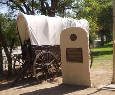
Contrary to popular belief, the emigrant wagon was not the large heavy Conestoga that is represented by the Idaho Bicentennial Wagon. Instead, many people used wagons from their farms or purchased smaller, lighter wagons at the start of their . . . — — Map (db m125727) HM
A perilous ford at Three Island State Park was a formidable Oregon Trail barrier. Those who could not cross here faced a longer, more difficult southern route. No other ford between Missouri and Oregon troubled them so much. This was their largest . . . — — Map (db m31677) HM
Stretching from Independence, Missouri, to Oregon City, the two thousand mile Oregon Trail lured over 300,000 pioneers on a long six month journey. When pioneers entered present-day Idaho, many had traveled more than one thousand miles of hot, dusty . . . — — Map (db m125674) HM
Thursday July 24
"Traveled 13 miles struck the river 2 miles above the ford. Here we found a company ferrying in wagon beds we unloaded two our best wagon beds and commenced calking them got them finished and ferried their loads that . . . — — Map (db m125677) HM
Thursday August 14 "...We had a squally time ascending the bluffs, which are severaly hundred feet high. We passed from a hill to the side of a bluff, upon a high narrow ridge of just sufficient width upon the top for the wagon road, the . . . — — Map (db m125733) HM
Sunday July 27 "Traveled 15 miles 5 miles brought us to a marshy hollow (Hot Springs Creek) which wound to right of the direction were traveling. Traveled in this marsh 3 miles then drove out leaving this marsh to our right..." -- Susan . . . — — Map (db m125751) HM
Directly in front of you, the Oregon Trail descends the steep bluff to the Snake River. The trail lies parallel to and directly above the major road scar that is easily seen. On sunny days, the trail is visible to the keen eye.
While the . . . — — Map (db m125725) HM
Located on an old Indian and fur trade route, the Three Island Ford presented a difficult challenge to the emigrants. Those who dared attempted this crossing using the southern two islands and connecting sand bars to cross the river. Those who were . . . — — Map (db m125726) HM
To all pioneers who crossed over Three Island Crossing and helped to win the west. Erected 1931 by Troop One Boy Scouts of America Roslyn, New York Scoutmaster E.K. Pietsch Reproduced 1990 — — Map (db m31679) HM
John C. Fremont reported using the Canyon Creek crossing in 1843 and Lansford Hastings's 1845 Emigrant's Guide to Oregon and California listed the site as an important Oregon Trail crossing and campsite. Emigrant diaries report frequent use of the . . . — — Map (db m125784) HM
Eight miles east of here, Rattlesnake Station, was an important stop for wagon trains and travelers along the Oregon Trail because of its sure supply of fresh water. Later, a stage station with a post office called "The Mountain Home" was . . . — — Map (db m129572) HM
347 entries matched your criteria. Entries 101 through 200 are listed above. ⊲ Previous 100 — Next 100 ⊳