This 12-acre nonsectarian plot was established in 1729 when George Fox set aside 1/4 acre as a resting place for locals who had passed from life. Captain Daniel Bray, the Revolutionary War here is among those interred here. — — Map (db m83141) HM
The first burial on this former farm of John Barber, Esq. was circa 1750. Early settlers, prominent citizens, slaves, war veterans, and politicians such as U.S. Senator & NJ Governor John Lambert Sr. are buried here. — — Map (db m83104) HM
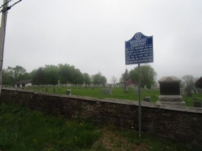
The old part of this plot is also known as the Dunkard Cemetery. The 1840 will of Gideon Moore donated the property including a wall. Many early church members lie here, including its 50 year pastor, Rev. Israel Poulson. — — Map (db m83103) HM
Laid out on the farm of Johannes Nuhl (later Anglicized to Newell) who had come from Staten Island c. 1730, this is the burial ground of many of his descendants over the years and now serves as an area community cemetery. — — Map (db m101528) HM
This wall encloses a portion of a plot of two acres whereon was erected in 1704 the first Christian church within the present confines of Mercer County.
Early records refer to it as “Hopewell Church” and “Christ Church”.
It was built . . . — — Map (db m4073) HM
Near here lie buried the
American and British officers
and soldiers
who fell in the Battle of Princeton
January 3rd, 1777
Here freedom stood by slaughtered friend and foe, and ere the wrath paled or that sunset died, looked through the . . . — — Map (db m149806) HM
This colonnade was originally part of Mathew Newkirk’s home in Philadelphia, Pennsylvania. Later called St. George’s Hall. The house was designed by Thomas U. Walter, who later designed the dome on the U.S. Capitol Building in Washington, D. C. In . . . — — Map (db m10153) HM
Near this spot lie the remains of Nathaniel Fitz Randolph, the generous giver of the land upon which the original buildings of this University were erected. In Agro Jacet Nostro Immo Svo — — Map (db m62343) HM
In 1861
Capt. John H.S. Margerum
risked his life by
climbing to the dome of
Nassau Hall to erect
The Stars and Stripes of
the Union Jack — — Map (db m150264) HM
A signer of the Declaration of Independence is buried in these grounds 1730 – 1781 --------------- Erected by The New Jersey Society of the Sons of the American Revolution 1913 — — Map (db m44844) HM
This is the third First Church, the previous two (1726 & 1804) having been built elsewhere on the lot. The burial yards flanking the church include a mass grave of Hessians killed in the first Battle of Trenton, and the grave of Col. Rall, their . . . — — Map (db m208088) HM
Trenton’s first Jewish organization, Mount Sinai Cemetery Association, formed November 19, 1857, later known as Har Sinai Hebrew Congregation, began regular synagogue services at this site in 1860. — — Map (db m3654) HM
The British occupied this site in December, 1776. Buried in its small graveyard are Revolutionary War figures, including George Clymer and General Philemon Dickinson. Clymer, a Pennsylvanian who helped finance the Continental Army, signed the . . . — — Map (db m208093) HM
Originally known as the English Church, St. Michael's closed for seven years during the Revolution. The church was largely rebuilt in 1819. David Brearley, a signer of the Constitution, state chief justice and Washington's appointee as New Jersey's . . . — — Map (db m208095) HM
Born 1835 in Trenton.
He was the son of Stacy A. Paxson, a former New Jersey state treasurer. At the outbreak of the Civil War he joined Company D, 48th New York Infantry Volunteers (Die-No-Mores), which was made up of men from Trenton, and . . . — — Map (db m4470) HM
Born Dec. 18, 1824, in New York City.
Early in life he was principal and teacher of mathematics at the grammar school of Columbia College. He left Columbia in 1845 to join the Cooper Iron Works in Trenton. Responsible for various inventions . . . — — Map (db m4467) HM
Born April 16, 1814, in Tuckerton, NJ.
He operated country general stores throughout Burlington and Monmouth Counties before moving to Trenton.
He served as Chancery Court clerk of New Jersey from 1851 to 1856 and served as mayor of Trenton . . . — — Map (db m9891) HM
Born April 8, 1786, in Hunterdon County, N.J.
A graduate of the College of New Jersey (Princeton University), he studied at the University of Pennsylvania Medical Department (1812) under Dr. Benjamin Rush, signer of the Declaration of . . . — — Map (db m4468) HM
Born June 19, 1856, in Wilkes-Barre, Pa.
He graduated third in the class of 1877 at Princeton University.
He served on the Trenton Board of Education (1894-1896); Trenton Common Council (1896-1900); Trenton Board of Trade (1896-1900); New . . . — — Map (db m4471) HM
Born May 16, 1810 in Staffordshire, England.
Taylor came to the United States in 1829 and settled for a time in Jersey City. He worked in the potteries of Troy, Indiana; Orrsville, Kentucky; Cincinnati, Ohio, and East Liverpool, Ohio, to . . . — — Map (db m4465) HM
Born 1824, in Mill Hill, now a part of Trenton.
In 1854, he was the first, with Jesse M. Clark and Randolph H. Moore, to publish a city directory that included all the names, addresses and occupations of the people of Trenton.
He was . . . — — Map (db m4466) HM
(On the Left Side)
Organized 1842
Restored 1992
(On the Right Side)
Within these walls rest statesmen, politicians, soldiers and plain citizens of 19th century Trenton. Mercer Cemetery itself is a monument to their . . . — — Map (db m4543) HM
Mercer Cemetery, the first non-sectarian cemetery in New Jersey, is designated as a Trenton City Landmark. Organized in 1843, the cemetery was once the preferred final resting place for many of Trenton's prominent families.
The cemetery . . . — — Map (db m208120) HM
Mercer Cemetery, the first non-sectarian cemetery in New Jersey, is designated as a Trenton City Landmark. Organized in 1843, the cemetery was once the preferred final resting place for many of Trenton's prominent families.
The cemetery . . . — — Map (db m208122) HM
Born May 1, 1844, in Staffordshire, England.
Beech emigrated to Boston in 1848. In 1856, he moved to Trenton and found a job with City Pottery, at the corner of Perry and Carroll Streets.
Beech joined Co. B, 4th New Jersey Volunteer Infantry . . . — — Map (db m4464) HM
Born 1807, in Trenton.
He was the editor of the New Jersey State Gazette early in his career. Later a member and president of the Common Council, he served the short term as mayor of Trenton – April 6 to 9, 1855 – filling the vacated seat of . . . — — Map (db m4542) HM
Born 1803.
Active in area business and politics, he was part-owner of VanCleve & McKean Iron Manufacturing Co., which eventually became the Trenton Locomotive and machine Manufacturing Co. (at South Broad St. and Hamilton Ave.), the first to . . . — — Map (db m4469) HM
Born Dec. 5, 1801, in Longnor, Staffordshire, England.
He emigrated to the United States in 1842, but remained only for a short time before returning to his native England, where he started a pottery. When it failed to produce a profit by 1848, . . . — — Map (db m4472) HM
This tablet is dedicated to the memory of those men who served in the American Revolution
1775 – 1783
and who were buried in the
First Presbyterian Churchyard
Trenton, N.J.
James Francis Armstrong •
John Beatty •
Nicholas de . . . — — Map (db m4005) HM
George Clymer
Signer of the Constitution of the
United States of America
Deputy from Pennsylvania to
Federal Constitutional Convention
May 25, 1787 – September 17, 1787 — — Map (db m4007) HM
In memory of Mahlon Stacy the first English settler, 1679, who owned the land both sides of the Assunpink Creek at the Falls of Delaware, now Trenton. He erected a grist mill to accommodate the neighborhood; was a member of the Governor’s Council; . . . — — Map (db m3831) HM
In memory of
Rev. John Rosbrugh
Clerical Martyr of the Revolution
Moderator of the
Presbytery of New Brunswick
1776
Chaplain 3d Battalion
Northampton County PA Militia
December 25, 1776
Bayoneted to death by Hessians
in . . . — — Map (db m4006) HM
A Bicentennial Commemorative Site recognizing America's 200th year of liberty
Organized 1712
Present Building erected 1839
We are bound to God’s will
(On another marker nearby on the front porch:
Presbyterian Church
Formed 1712 . . . — — Map (db m3993) HM
Riverview Cemetery, today a wedge of green between two major highways, is an oasis in the concrete and asphalt of the city where Trenton’s history is written silently in gravestones. Here in 1685, John Lambert conveyed two acres to the . . . — — Map (db m166125) HM
Civil War MonumentThe Civil War Soldiers Monument in this cemetery, located behind the church building complex, is one of New Jersey’s earliest Civil War monuments. On June 3, 1865, Reverend Joseph Gaston Symmes of the First Presbyterian Church . . . — — Map (db m122264) HM WM
The Sexton's House
The adjacent private home located at 3 Westminster Place was constructed in 1840 as the home of the Sexton of the Church. As with most historic homes in Cranbury, this house has been modified since its original . . . — — Map (db m95880) HM
In October 1880. Dr. Ezra M. Hunt of Metuchen listed all the graves in
the Piscatawavtown Burial Ground. He identified five graves in the
south-west corner as the "Colored Burial Ground”. Subsequent to
Dr. Hunt's list. there were two . . . — — Map (db m192905) HM
St. James Episcopal Church was established in 1704. The original structure was built in 1724. In 1835 the church was destroyed by a tornado. It was rebuilt using as much of the original wood and fixtures as possible. The rear section was built in . . . — — Map (db m53332) HM
St. Peter’s is the oldest parish in the state. Founded in 1698 when the Bishop of London sent the Rev. Edward Portlock to be its’ minister. Chartered in 1718 by King George I. Used as a barracks for British troops in 1776. Here the colonial . . . — — Map (db m7901) HM
Here lies the body of Thomas Mundy Peterson first negro voter in the United States under the fifteenth amendment at an election held in Perth Amboy March 31, 1870. A devoted churchman and good citizen. Member of a committee to revise the city . . . — — Map (db m84530) HM
Elsie, a purebred Jersey cow with enormous
brown eyes was chosen to be the
advertising symbol for the Borden Company.
This became one of the best known and most successful
icons in the history of American marketing.
Elsie was featured at . . . — — Map (db m36922) HM
Site of an early colonial burial ground associated with the hamlet of Samptown. This place was chosen by local Baptists to be the location of the meeting house of the newly formed Samptown Baptist Church in 1792.
The first church building was . . . — — Map (db m93988) HM WM
The First Presbyterian Church of Woodbridge is home to the oldest Presbyterian congregation in Middlesex County and the sixth oldest in the state. Located at 600 Rahway Avenue and known as “The Old White Church”, its first service was conducted . . . — — Map (db m125836) HM
In memory of the Revolutionary soldiers and patriots of Woodbridge, New Jersey
Placed by Janet Gage Chapter Daughters of the American Revolution — — Map (db m7904) HM
First used for burial in 1714.
Place of interment for many
prominent Woodbridge families
and veterans from each war beginning
with the
American Revolution
1714 — — Map (db m194312) HM WM
Trinity Episcopal Church of Woodbridge is among the oldest Episcopal congregations in New Jersey. Now located at 650 Rahway Avenue, its first service was conducted in 1698; the first sanctuary was built in 1713 under the leadership of Rev. Edward . . . — — Map (db m126154) HM
Born in Bound Brook, N.J. Aug. 30, 1758 son of Benjamin & Margaret Field. Wounded and captured in the Battle of Monmouth Court House. Left in this area by the British in their retreat. Whether he died of his wounds or was slain by his captors is . . . — — Map (db m76329) HM
The Crawford Cemetery, the Garden State Arts Center and the New Jersey Vietnam Veterans Memorial are located on land that was a part of a 1219 acre tract granted to John Bowne in 1687 from the King of England.
John Crawford emigrated to . . . — — Map (db m209034) HM
In grateful remembrance of patriots who, on Sabbath June 28,1778, gained the victory which was the turning point in the War for Independence, and to mark a memorable spot on the battlefield of Monmouth.
[Plaque located opposite main . . . — — Map (db m6172) HM
These Patriots, original members of the Society of the Cincinnati in the State of New Jersey lie buried in this churchyard. Lieutenant James Anderson Lieutenant Colonel David Rhea Colonel Nathaniel Scudder Ensign Moses Sprowl Captain George Walker . . . — — Map (db m97092) HM
Site of church and graveyard of Matawan’s original Scots settlers. The church was built in 1734. The graveyard added in 1763.
The church was burned by Tories in 1777 and the Rev. Chas. McKnight taken prisoner. The deed was held by the Monmouth . . . — — Map (db m93766) HM
Eloquently fired the spirit of the people with poems and ballads promoting the cause of liberty. Friend of James Madison and Thomas Jefferson, published the Jersey Chronicle, first newspaper in Monmouth County. — — Map (db m76324) HM
Philip Freneau Died Dec. 18th 1832 Aged 80 years 11 months and 16 days He was a native of New York but for many years a resident of Philadelphia and New Jersey. His upright and benevolent character is in the memory of many and will remain when . . . — — Map (db m76327) HM
In this cemetery are buried some of the pioneers who settled this portion of Morris County. Also resting here are a handful of Hessian soldiers, who were recruited to labor at what is now known as Picatinny Arsenal, in support of America's quest for . . . — — Map (db m52588) HM
Jockey Hollow Cemetery More than one hundred Continental soldiers who made the supreme sacrifice for American Liberty are buried in this cemetery. Their comrades were housed in huts along the Jockey Hollow Road. The people of Morristown reverently . . . — — Map (db m8532) HM
Colonel Jacob Ford, Sr.
Prominent land-holder and iron manufacturer
Member of New Jersey House of Assembly
Judge of Morris County Court
Ardent promoter of American cause in Revolutionary War
Born April 13, 1704 Died January 19, 1777 . . . — — Map (db m7553) HM
Designated a National and a State Historic Place in 2009, the Whippany Burying Yard, established in 1718, was donated to the people of Whippanong by schoolmaster John Richards. The burying yard contains the graves of veterans of the Colonial, . . . — — Map (db m91155) HM
Township of Hanover Historic Sites Committee-This land was given by John Richards to his Christian Friends and neighbors to erect a suitable meeting house for the public worship of God, a School House, Burying Yard and Training Field. The first . . . — — Map (db m91156) HM
Toms River residents Joseph and Mary Lawrence owned a large strip of undeveloped land located south of Washington Street that extended to the river's edge. They deeded one acre of this land to the trustees of the Toms River Meeting House. It . . . — — Map (db m208340) HM
To keep in perpetual remembrance the names of the real Daughters of the American Revolution buried here Rachel Benson • Lena Brower • Maria Egbertse • Peggy Garrison •Elizabeth Hoffer • Margaret Kenter • Mary Kinsey • Jane Mead • Annie Montanie • . . . — — Map (db m36164) HM
This tablet marks the grave of Henry Garritse who died July 13, 1805, aged 84. A revolutionary patriot, member of the Committee of Correspondence, Provincial Congress, and first member of the legislature from Acquackanonk. Claverack Chapter . . . — — Map (db m36155) HM
These two tombstones stood at the heads of the graves about 75 feet northwest of this spot. The bolt and shaft bearing were taken from the old gristmill at John Halmagh Post’s birthplace, Sloughter Dam, now 472 River Road, Garfield, New Jersey. . . . — — Map (db m36152) HM
Born 1735 in Scotland Died 1780 at Ringwood Friend in need for Washington Geographer and Surveyer General for the American Army in the Revolutionary War A true and faithful Christian patriot Erected by the New Jersey Society of the S.A.R. . . . — — Map (db m43139) HM
Four score and seven years ago our fathers brought forth on this continent, a new nation, conceived in Liberty, and dedicated to the proposition that all men are created equal. Now we are engaged in a great civil war, testing whether that . . . — — Map (db m114213) HM
Erected by the United States to mark the burial place of 2436 Confederate soldiers who died at Fort Delaware while prisoners of war and whose graves cannot now be individually identified. — — Map (db m21655) HM
Near this stone lie the remains of 105 United States soldiers whose names so far as known are hereon inscribed, but whose graves cannot be identified. They died for their country. — — Map (db m21656) HM
This oak tree, a survivor of the original forest, was standing here when Salem was founded by John Fenwick in 1675. It is eighty-eight feet high and its foliage covers one-quarter of an acre. “This tablet was erected on October 10th, 1925, . . . — — Map (db m21659) HM
Three African Americans are interred in this Friends cemetery.
From the records:
"Rachel Mintiss (Colored), wife of Andrew Mintiss was buried 5th mo. 8th 1846 on the hillside, near the 1st Row of the 2nd purchase.
Andrew Mintiss . . . — — Map (db m209376) HM
A log Hospital for Continental Army soldiers was located on the slope of this ravine. A frame Presbyterian Church stood at the top of the hill near the famous oak and burial ground. — — Map (db m8526) HM
In memory of the Revolutionary War soldiers buried in the graveyard of the Basking Ridge Presbyterian Church
Alward, Benjamin •
Ayres, John •
Ayres, Nathaniel •
Baird, John •
Bockoven, George •
Boylan, John •
Brees, John Jr. • . . . — — Map (db m21970) HM
On June 22, 1801, three African American Men - one free Negro and two slaves - purchased one tenth on an acre of land from Aaron Melick for the sum of three dollars to establish a burying ground for the "Black people of the Neighborhood." This is . . . — — Map (db m96788) HM
There are 97 identified graves here: 36 with names and 61 unknown, including former slaves and free blacks who were members of the Lamington Presbyterian Church. Remains of 5 Civil War veterans who fought heroically for the Union lie here. As you . . . — — Map (db m16975) HM
This family cemetery served the Opies and Vanderveers from the late 1700s into the early 1800s and is the resting place for at least sixteen family members. In 2001 it was restored by Montgomery Boy Scout Troop 46 as an Eagle Scout Service Project . . . — — Map (db m96151) HM
Historic Baptist church and Revolutionary War burial grounds built in 1761 on the Old Quibbletown Gap Road. Chartered in 1767. Moved to the present location in 1785. One of the oldest surviving Baptist buildings in New Jersey.
A state and . . . — — Map (db m32985) HM
Layton, once known as Laytons, was originally named Centreville. This village was settled by John Layton in the early 1800's. The first business here was owned by blacksmith Simeon Fisher, followed by Abraham Bell who established a carpenter's shop . . . — — Map (db m60343) HM
In 1750, several families left the Congregational Church of Mansfield, CT relocating to New Jersey with William Marsh, their spiritual leader. Building a log meeting house here, they associated with the Baptist faith in 1750. As the church . . . — — Map (db m193425) HM
Oldest portion dedicated in 1762 as part of Town Plot. Enlarged about 1820. Job S. Halsted donated 3/5 acre in 1837 to Presbyterian Church. Enclosed by wall in 1837. By 1876, burials estimated at 5000 including many of the earliest settlers of the . . . — — Map (db m63382) HM
From 1664 until 1703, the First Presbyterian Church of Elizabeth was the only house of worship serving most of current-day Union, Morris, Somerset and Hunterdon Counties. The oldest stones in the cemetery are from the year 1687 and are located in . . . — — Map (db m144144) HM
Honoring the patriotic dead of many wars laid to rest in this hallowed ground especially a noble woman Hanah White Arnett Placed here on the 45th anniversary of the organization of Boudinot Chapter Daughters of the American Revolution September . . . — — Map (db m40714) HM
Their names are imperishably inscribed upon the country’s Roll of Honor. --------------- Within this sacred ground rest the remains of a number of soldiers, of whom there is a record of forty-eight, all enrolled in Washington’s Army during the . . . — — Map (db m8864) HM