Near Hutchins Landing Road, 0.2 miles east of Hillside Plantation Road, on the right when traveling east.
[Top plaque] United Methodist Historic Site No. 80
[Bottom plaque] This property has been placed on the National Register of Historic Places by the United States Department of the Interior — — Map (db m243643) HM
On Trails End Road west of North Palestine Road, on the right when traveling south.
"Soldiers Retreat," located here, was the home of Ferdinand Leigh and Magdaline Claiborne. F.L. Claiborne (1772-1815) moved to the Mississippi Territory from Virginia in 1807 and served as Brig. Gen. with the 1st Mississippi Volunteers during the . . . — — Map (db m105260) HM
On South Union Street north of Main Street, on the right when traveling north.
In 2012, the Diocese of Jackson celebrates the 175th anniversary of its founding by Pope Gregory XVI. The Bishop's Prayer Garden, located on the old catholic burial ground, is dedicated in this year to the seven deceased Bishops of Natchez who . . . — — Map (db m115630)
On North Dr. Martin Luther King Street at St. Catherine Street, on the right on North Dr. Martin Luther King Street.
The original appearance of Mt. Sinai Baptist Church is visible in a ca. 1930 historic photograph. The church featured corner towers crowned with domes.Mt. Sinai organized in 1913 and built the church soon afterwards. Like most historic African . . . — — Map (db m108636) HM
On Saint Catherine Street west of Orange Avenue, on the left when traveling west.
First Catholic church in the Mississippi valley with entire congregation of Afro-American descent. Its school has been continually educating youth since 1890. — — Map (db m103798) HM
On St. Catherine Street at Orange Avenue, on the right when traveling west on St. Catherine Street.
In 1889 Bishop Thomas Heslin started the first parish for Roman Catholic African Americans in Mississippi. He first oversaw construction of a small frame church (above left) on Beaumont Street and brought Father A.N.J. Peters to Natchez to become . . . — — Map (db m104502) HM
Near South Union Street near Main Street, on the right.
1830: July 18-December 30- The Blessed Virgin Mary appears to St. Catherine Lebouré, Daughter of Charity, in Paris, France 1830: July 27 Revolution - Louis Philippe overthrows King Charles X of France 1832: - First Miraculous . . . — — Map (db m104067) HM
On North Rankin Street at Jefferson Street, on the right when traveling south on North Rankin Street.
Zion Chapel African Methodist Episcopal (A.M.E.) Church was built in 1858 as the Second Presbyterian Church, a mission of First Presbyterian Church. Zion Chapel acquired the building in 1866, when Hiram R. Revels served as pastor. The . . . — — Map (db m127093) HM
On Jefferson Street near North Union, on the right when traveling west.
Ethel Clagett and Mabel Porter were among the first women in America to own a car dealership that was not inherited from a male spouse or relative. They opened their dealership in 1914 on Main Street and moved to a larger new facility on . . . — — Map (db m108610) HM
On South Union Street at Main Street, on the left when traveling north on South Union Street.
An 1890 view of Memorial Park shows the Confederate soldier monument draped for unveiling. Like many others across the south, it faces north towards the opposing army.The park's creation was part of the Lost Cause Movement that expressed . . . — — Map (db m104480) HM
On Franklin Street at North Pearl Street, on the left when traveling east on Franklin Street.
The dramatic looking Natchez Hotel (no longer standing) was built in 1891. Within a few years, parts of the building began to disappear in stages. The tent-like dome went first in a storm, and a 1926 fire destroyed most of the structure. . . . — — Map (db m127090) HM
On South BroadwayStreet near Washington Street, on the right when traveling south.
Edelweiss is a Swiss Chalet-style building which dates to 1883. The house offered both a great view of the Mississippi River and a convenient location for the family of its first owner, Joseph O'Brien, a coal-dealer at Natchez . . . — — Map (db m108807) HM
On South Commerce Street at Washington Street, on the right when traveling south on South Commerce Street.
The present Temple B'nai Israel, built in 1904, replaced an 1870s temple that burned (pictured above). Both reflect the success of Jewish merchants after the Civil War. Jews lived in Natchez as early as the late 1700s, but their numbers . . . — — Map (db m114299) HM
On Jefferson Street at North Union Street on Jefferson Street.
This was the first Methodist congregration in Natchez formed in the early 1800s, and the 1st building was constructed in 1807. The 1st Sunday School south of Philadelphia, Pa., was organized here in 1829. — — Map (db m29749) HM
On Co-Lin Circle west of Campus Drive, on the left when traveling west.
An early American feminist writer and champion of women's rights, Murray (1751-1820) was also instrumental in fostering the Universalist Church in America. Murray lived for two years at Oak Point Plantation on this site. She died on July 6, 1820, . . . — — Map (db m103817) HM
On Hutchins Landing Road, 0.3 miles east of Hillside Plantation Road, on the right when traveling east.
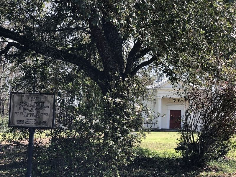
S.E. 1 mile is site of Old Jersey Settlement now known as Kingston. Here settlers from New Jersey organized first Protestant church in Mississippi with Samuel Swayze as pastor. — — Map (db m104043) HM
On U.S. 61 at Kingston Road, on the right when traveling north on U.S. 61.
E. 8 mi. Settled, 1773 by N. Jersey pioneers led by Richard and Samuel Swayze. Latter formed Congregational church, reputedly the first Protestant church in state. — — Map (db m120192) HM
On U.S. 61 at Kingston Road, on the right when traveling north on U.S. 61.
8.8 Miles to KINGSTON First Protestant Settlement In Mississippi Territory 1773.Dedicated 1955 by The National Society Of The Colonial Dames of America In The State Of Mississippi. — — Map (db m120264) HM
On Liberty Road at Stanley Davis Road, on the right when traveling west on Liberty Road.
The original church was located on Montgomery Plantation when it burned down during the civil rights movement of 1963. It was rebuilt at this site in 1964. — — Map (db m136946) HM
On Madison Street east of North Union Street, on the left when traveling east.
Rose Hill is the oldest black baptist congregation in the state, with origins dating to 1837. This 1908 building replaces the first wooden church and contains a 1912 Moller pipe organ. Randle Pollard was the first official pastor, serving from . . . — — Map (db m105229) HM
On Franklin Street at Locust Street, on the right when traveling south on Franklin Street.
Erected 1807. Launer Blackman, Elder. Caleb W. Cloud Pastor. Trustees: Launer Blackman, Newit Vick, Reuben Gibson, W. Foster, Phillip Gorral, David Lattimore. This tablet placed 1935 by Jubilee Circle of W.M.S Jefferson St. Ch. — — Map (db m97262) HM
Near Aldrich Street near Old Devereaux St, on the left when traveling west.
William St. John Elliot, a wealthy planter, died in
1855. He willed his mansion. D'Evereux Hall, to the
Catholic church to become a boys' orphanage. His
widow, Anna Elliot, who wanted the house to remain
in her family, purchased the estate from . . . — — Map (db m226716) HM
On Morgantown Road at T Waring Bennett Jr. Road, on the left when traveling north on Morgantown Road.
On January 21, 1905, a number of families from struggling farming communities near Bologna, Italy, left Genoa bound for New York aboard the S.S. Montevideo. Many of these families ventured south, some settling in this area near St. . . . — — Map (db m105231) HM
In 1837 Natchez was designated the See of the Roman Catholic Church in Mississippi. In 1842 Bishop J. M. Chanche began construction of this structure, the only church built as a cathedral in Mississippi. — — Map (db m103791) HM
On South Commerce Street at Washington Street, on the left when traveling south on South Commerce Street.
Jewish Americans have been part of Mississippi’s economic, social and political life since the 1780’s. In 1843, the Jewish community of Natchez grew large enough to organize and sustain the state’s first permanent religious congregation, Temple . . . — — Map (db m79345) HM
On State Street at Pearl Street, on the left when traveling east on State Street.
Congregation organized in 1817. The Sanctuary was built in 1828-29 and enlarged in 1851. The Romanesque Revival rear addition was built in 1900 in honor of Joseph Stratton, Pastor, 1843-1903. The church and its companion manse on South Rankin Street . . . — — Map (db m19027) HM
On South Commerce Street south of Washington Street, on the left when traveling south.
Trinity Episcopal Church's congregation
was founded in 1822. The church building,
designed by architect John Munce and built
by George Williams, was constructed in
1822-1823. The structure is largely original.
except for a dome removed in 1839 . . . — — Map (db m193128) HM
On Jefferson Street near North Doctor Martin Luther King Jr. Street, on the left when traveling west.
Acquired 1868 by Zion Chapel whose minister Hiram R. Revels became the first black U.S. Senator and first president of Alcorn State University. Originally built in 1858 as the Second Presbyterian Church. — — Map (db m103793) HM
On North Martin Luther King Street at St. Catherine Street, on the right when traveling west on North Martin Luther King Street.
Henry Gurney photographed Zion Chapel A.M.E. Church in 1866, the year the congregation bought the building built in 1858 as the Second Presbyterian Church. Zion Chapel had earlier purchased the Methodist Church that fronted Union Street between . . . — — Map (db m110513) HM
On Martin Luther King Junior Road (Mississippi Route 555) at Airport Road (Mississippi Route 554), on the right when traveling south on Martin Luther King Junior Road.
Oldest Presbyterian Church
in S.W. Organized. Feb. 25, 1807
as Salem Church. Here, Mar. 6,
1816 Mississippi Presbytery
was formed. Name changed
in 1827 to Pine Ridge Church. — — Map (db m244195) HM
Near Emerald Mound Road, 1 mile west of Natchez Trace Parkway, on the right when traveling west.
Before you is the second largest temple mound in the United States. Only Monks Mound in Cahokia, Illinois, is larger. This eight acre mound, constructed from a natural hill, was built and used from about 1300 to 1600 by the Mississippians, . . . — — Map (db m61974) HM
Near Emerald Mound Road, 1 mile Natchez Trace Parkway, on the right when traveling west.
Before you is a 30 foot secondary mound on which once stood a temple containing sacred Indian images.
Archeological evidence indicates that at least two small mounds stood along the North and South sides of the primary platform. These mounds . . . — — Map (db m87272) HM
On U.S. 61 at Morgantown Road, on the left when traveling west on U.S. 61.
Site of first Methodist camp meeting in state, Dec. 14-17, 1804. Led by Learner Blackman, Nathan Barnes, Lorenzo Dow, and Randal Gibson. — — Map (db m105847) HM
On New Hope Road (County Road 513) 0.4 miles west of U.S. 45, on the right when traveling west.
New Hope Presbyterian Church was organized in 1838 when six members began meeting in a school house near Troy, later renamed Danville. Rev. James B. Stafford served as the first pastor or the church from 1838 to 1854. The first sanctuary was a log . . . — — Map (db m155410) HM
On County Road 106 north of County Road 187, on the right when traveling north.
Organized before 1848. Here in 1853 M.P. Lowery was ordained & in 1885 John Allen was dubbed "Private". Town destroyed in Civil War & abandoned because R.R. by-passed it. — — Map (db m155237) HM
Corinth's oldest church bldg.; erected 1871 by Cumberland Presbyterian Church, the First church est. in Corinth. 1906~1976 served as Fillmore St. Pres. Ch. Now used as chapel by First United Methodist Church. — — Map (db m28472) HM
On Perry Road north of Ewell Road, on the left when traveling north.
[Top plaque] This property has been placed on the National Register of Historic Places by the United States Department of the Interior
[Bottom plaque]
Bethany Presbyterian Church
Organized in 1808, Bethany . . . — — Map (db m243301) HM
On Walnut Drive at North Church Streeet, on the left when traveling north on Walnut Drive.
Founded as the Liberty Colored Church in March 1870 after fifteen black members requested letters of dismissal from Liberty Baptist Church to organize their own congregation. Under the leadership of their first pastor, Rev. Fred Stirling, these . . . — — Map (db m92617) HM
On North Greensburg Road at East Fork Roar, on the right when traveling south on North Greensburg Road.
Constituted Saturday, September 15, 1810 in
the home of James Chandler on the East
Fork of the Amite River. Charter members
Joseph Chandler, John Wilson, Ephraim
Puckett, James Keith, John Prestridge,
Lazarus Reeves, Elizabeth Simmons, . . . — — Map (db m199205) HM
On Natchez Trace Parkway (at milepost 176.3), 0.1 miles south of County Road 3122, on the right when traveling north.
About half a mile northwesterly, Bethel, meaning “House of God” was opened in 1822 as one of thirteen Choctaw mission stations. Indians, slaves, and other men “labored hard during four weeks ... frequently till 10 o’clock at night, . . . — — Map (db m87479) HM
On Mississippi Route 12 at Mississippi Route 429, on the right when traveling east on State Route 12.
South 4 mi. Founded, 1846. Here, July 22, 1855, first Mississippi Lutheran Synod was organized. The Rev. G.H. Brown, pastor, served as first Synod president. — — Map (db m140802) HM
On Ruby Street near Aloe Avenue, on the right when traveling east.
Side 1
Despite their conceptual differences, gospel, the Sunday morning music of the church, and blues, the Saturday night music of the juke joint, share some of the same roots, influences and musical traits. Many African African singers have . . . — — Map (db m170501) HM
On East Sunflower Road (State Highway 8) 0.2 miles east of North Davis Avenue (U.S. 278), on the right when traveling east.
Founded in 1937 by parents, Cleveland First Baptist Church, and community leaders to provide an education for children of Chinese descent who were excluded from area schools by the 1927 US Supreme Court decision, Gong Lum v. Rice. Students . . . — — Map (db m90066) HM
On Main Street (State Highway 1) north of Vorhees Street, on the right when traveling north.
Built in 1879, this vernacular Carpenter Gothic structure is the oldest extant church in Bolivar County. Congregation organized by 1875 under Bishop Wm. M. Green. Listed in Register of Historic Places. — — Map (db m154854) HM
On George Street (Mississippi Route 17) south of McCain Street, on the right when traveling south.
The Carroll County Tabernacle
was established in 1922 when
T.N. Bloodworth donated nearly
two acres of land to organize a
Methodist revival meeting place.
Funds were raised in 1929 to
erect a meeting place that could
seat 1.000 attendees. The . . . — — Map (db m170283) HM
On Front Street (U.S. 51) at East Herring/Greensboro Street (County Road 430), on the right when traveling north on Front Street.
E. 150 ft. Organized at Old Shongalo, 1mi. W., by Clinton Presbytery, Aug. 29, 1835. Rev. A.C. Dickerson was first minister. Present structure completed 1875. Upper story built and used by Masons. — — Map (db m179027) HM
On North Church Street (Mississippi Route 245) at Laster Drive, on the right when traveling south on North Church Street.
The Okolona Normal and Industrial School was founded in 1902 by Dr. Wallace A. Battle. It educated African Americans through high school and provided industrial training for young adults. At its peak, the school's enrollment topped two hundred . . . — — Map (db m102740) HM
Near Lebannon Road, 0.2 miles north of South Union Road, on the right when traveling north.
Begun in 1840 by Rev. William A.
Gray. First building destroyed
by tornado in 1883 and
rebuilt on same site in 1887.
Known for its campmeetings,
held here annually since before
the Civil War. — — Map (db m244510) HM
On Mississippi Route 12, 1.4 miles west of Scott Road, on the right when traveling west.
Established ca. 1836, Shiloh Methodist Church was disbanded by 1875. Remaining members joined other churches in area, including Mt. Airy, Chestnut Grove, and Bethel. Frederick and Margaret Crawford Bagwell, early settlers of Choctaw County are . . . — — Map (db m140785) HM
On South Union Road, 0.1 miles Lebannon Road, on the right when traveling west.
During the War between the States there was a “great revival” of religious fervor through the Holy Spirit. In 1865, several Choctaw County Christian families knelt together in prayer and asked for God's guidance to direct them in His way, believing, . . . — — Map (db m244506) HM
On South Union Road, 0.1 miles west of Lebannon Road, on the right when traveling west.
Church begun 1865. Campmeeting begun 1872 on land
donated by William Parham
Pollard, 1830s pioneer. Summer
worshippers camped in wooden
tents surrounding the tabernacle.
Cemetery dates to 1840. — — Map (db m244505) HM
On Concord-Bethsalem Road, 0.1 miles north of Highpoint-Weir Road.
Begun ca. 1839 by Rev. James
Martin. Present building of
virgin pine erected in early
1840s. Known as “a mother of
churches,” it supported a session house, a school, and an
annual campmeeting. — — Map (db m244513) HM
On State Highway 552 at Russum Westside Road, on the left when traveling south on State Highway 552.
The original congregation of the Bethel Presbyterian Church organized in 1826 under the direction of Dr. Jeremiah Chamberlain, constructed this building in the mid 1840s. On the interior, ornamentation is completely lacking. The use of pilasters on . . . — — Map (db m105784) HM
Listed in National Register of Historic Places, the church building was constructed in 1868, as the once flourishing river town was declining. Church completion was in the year preceding the disastrous 1869 fire. Although there is no recorded . . . — — Map (db m104103) HM
During 1890, the priest's house was constructed and the mission received a Christmas gift from the Society at Brussels for "Poor Churches" as one of the most destitute churches of the diocese. This gift probably contained the vestments and altar . . . — — Map (db m104105) HM
At the end of this trail is evidence of a once thriving rural community. First settled in the late 1790's, the town grew from a watering place along the Natchez Trace, and took its name from the source of that water -- the Rocky Spring. In 1860, a . . . — — Map (db m80147) HM
On Rodney Road, 4.2 miles west of Church Street (U.S. 61), on the right when traveling west.
Following the arrival of Presbyterian missionaries in 1801, Joseph Bullen and James Smylie organized the Bayou Pierre Church at this site in 1807. After part of the congregation formed the Bethel Church southwest of here in 1824, the remaining . . . — — Map (db m70394) HM
On Farmer Street at Orange Street, on the right when traveling north on Farmer Street.
Founded in 1867 by freedmen. Moved to this site ca. 1896. Played a vital role in the Civil Rights Movement in Port Gibson. Beginning in 1965, the NAACP held meetings here to promote boycotts of local white merchants, who subsequently filed suit. In . . . — — Map (db m103805) HM
On Church Street (U.S. 61) at Walnut Street on Church Street.
Second oldest Presbyterian Church in Old Southwest. Org. April, 1807, as Bayou Pierre Church. Moved to Port Gibson 1827. Zebulon Butler first resident pastor, 1827-60. Present structure built 1859. — — Map (db m103807) HM
On Church Street (U.S. 61) at Walnut Street, on the right when traveling north on Church Street.
609 Church. 1859-60 Romanesque Revival. This church with the hand pointing to heaven is the most famous building in Claiborne County. The original hand of gilded wood was carved by young Daniel Foley. — — Map (db m104345) HM
On Shaifer Road, 0.5 miles west of Bessie Weathers Road, on the left when traveling west.
After firing the nighttime opening shots of the Battle of Port Gibson, Confederate skirmishers retreated to the ridge behind you to join the battle line that General Green formed in the dark. A volley from this line stopped the advancing Union' . . . — — Map (db m143740) HM
Near Natchez Trace Parkway (at milepost 45.7), 4.2 miles north of Mississippi Highway 18. Reported missing.
Excavation of this site tells us much about the people of the late prehistoric periods. The Plaquemine culture included the ancestors of the modern tribes of Mississippi and Louisiana. It was a society with elaborate agriculturally oriented . . . — — Map (db m87325) HM
On Church Street (U.S. 61) at Jackson Street, on the right when traveling north on Church Street.
901 Church. 1858-60 Romanesque Revival. The original building was constructed in 1826, but was destroyed by fire in 1858. The new church built on the same site, was dedicated July 8, 1860. — — Map (db m104399) HM
On College Street near Chinquepin Street, on the right when traveling north.
Methodists assumed ownership and the Academy was chartered as Port Gibson Collegiate Academy in 1854, becoming Port Gibson Female College in 1881. The school closed in 1928.
On December 21, 1933 deeds were filed in the courthouse . . . — — Map (db m139047) HM
On Church Street (U.S. 61) north of China Street, on the right when traveling north.
1103 Church Street. 1830-31 Greek Revival. This house was constructed the year following erection of the first building to house the First Presbyterian Church during the early ministry of Dr. Zebulon Butler. — — Map (db m139026) HM
On Church Street (U.S. 61) at Carroll Street, on the right when traveling south on Church Street.
808 Church. 1884-85. Ca. 1897 High Victorian Gothic. The architect was W.P. Wentworth from Boston. The entire structure reflects contemporary architectural developments in Massachusetts rather than in Mississippi. — — Map (db m104400) HM
On Church Street (U.S. 61) north of Orange Street, on the right when traveling north.
409 Church. Ca. 1885 High Victorian Gothic. This church was founded in 1870. The building is a simplified version of the High Victorian Gothic style popular in the United States in the latter half of the nineteenth century. — — Map (db m139491) HM
On Church Street (U.S. 61) at Carroll Street, on the right when traveling south on Church Street.
706 Church. 1891-92 Victorian Moro-Byzantine Revival. The architects of Temple Gemiluth Chassed, which means gift of the righteous, combined Moorish, Byzantine and Romanesque styles to produce a building unique in Mississippi. — — Map (db m104343) HM
On Martin Luther King Boulevard, 0.1 miles west of Yahoo Avenue, on the right when traveling west.
In the late 1880s a group of African Americans established the Macedonia Missionary Baptist Church near the Sunflower River, under the leadership of their first pastor Minister A. O. Gaston. The church would be moved to this location in 1918, . . . — — Map (db m90063) HM
On Yazoo Avenue at Martin Luther King Boulevard, on the right when traveling north on Yazoo Avenue.
Established in 1880 as Haven Memorial and
renamed Haven UMC in 1968, the church was
completed in 1923. Clarksdale's first low-income daycare was opened here in 1965
by Lilian Johnson. In 1958, Rev. Theodore
Trammel and Dr. Aaron Henry hosted . . . — — Map (db m174126) HM
On Delta Avenue north of Sunflower Avenue, on the right when traveling north.
The Hicks-Tarzi Memorial Grotto was built in the
early 1950s out of natural stone from Alabama
and recreates the Grotto of Lourdes, France.
The statues of the Blessed Virgin Mary and
Bernadette Soubirous were given in memory
of Johnny Tarzi and . . . — — Map (db m235164) HM
On Delta Avenue, 0.1 miles north of 1st Street, on the right when traveling south.
Originally named Kehilath Jacob, Clarksdale’s first synagogue was
built here in 1910. In celebration of the new temple, a Torah was
shipped from New York City and carried to the temple by members of
the congregation. In 1929, a larger temple was . . . — — Map (db m89923) HM
On 2nd Street at Church Street, on the left when traveling north on 2nd Street.
The Friars Point Methodist Church congregation was organized in 1836 under a nearby brush arbor. The original log church, on this site, was burned by Union troops during the Civil War. A second structure was destroyed by a tornado. The present . . . — — Map (db m170394) HM
On Rozell Street east of Sheriff Ridge Avenue, on the right when traveling east.
According to local tradition,
New Prospect M. B. Church was
established in the mid 1860s by
a former slave named Katherine
Armistead. New Prospect began as
Independence Church, in which
Methodists and Baptists shared
the sanctuary, each . . . — — Map (db m160395) HM
On Chautauqua Drive, 0.5 miles west of U.S. 51, on the right when traveling west.
The original amphitheater constructed of terraced ground and covered with sawdust sloping downward to the covered tabernacle was originally constructed in 1872 when the Brookhaven District of the United Methodist Church founded Hennington . . . — — Map (db m182923) HM
On U.S. 49 at State Route 590, in the median on U.S. 49.
East ¼ mile. Founded in 1846 as a coeducational boarding school by A.R. Graves, NY Presbyterian clergyman. Gave pre-law, pre-medical and fine arts training. Destroyed in the Civil War. — — Map (db m170485) HM
On Spencer Street at Milton Barnes Avenue, on the right when traveling north on Spencer Street.
On this site stood the old Mount
Zion Baptist Church, demolished in
1993. Known locally as "The Cvil
Rights Church", the church hosted
a "Freedom School” in 1964 and
many mass meetings during the
Civil Rights Movement. Dr. . . . — — Map (db m118478) HM
On Eatonville Road, 0.5 miles west of J.C.Bryant Road, on the left when traveling west.
Organized October 3, 1818.
First pastor,
Norvell Robertson, was a
Revolutionary soldier.
Eight charter members were
of the Granberry, Robertson
and Lee families. — — Map (db m175734) HM
On East Fifth Street east of J D Randolph Street, on the right when traveling east.
Organized in 1882 in a wood frame structure on the present site. In 1926, the original building was damaged in a storm. The present structure was built in 1930. The congregation provided food and shelter for Hattiesburg's flood victims in 1963 and . . . — — Map (db m118455) HM
On West Pearl Street at Water Street, on the left when traveling west on West Pearl Street.
Organized ca. 1868, Belle Flower
M. B. Church, one of the oldest
Black Baptist churches in
Grenada, served as a headquarters
and meeting place for a number of
organizations during the Civil
Rights movement. From its pulpit
such leaders as . . . — — Map (db m173971) HM
On Main Street near Federal Street, on the right when traveling west.
First established as the Elim Baptist Church in 1858, this congregation was dissolved in 1877 and revitalized in April 1896 as First Baptist Church under the leadership of Rev. O.D. Bowen. The church moved to this location on Main Street in October . . . — — Map (db m108381) HM
On Sycamore Street at Blaize Avenue, on the right when traveling east on Sycamore Street.
First Missionary Baptist Church, organized in
the home of Alexander Fox in 1877, was the
first Baptist congregation in Bay St. Louis.
The original church building was located
on Keller Street. After purchasing land
on Sycamore Street, the . . . — — Map (db m243137) HM
On South Beach Boulevard near Union Street, on the right when traveling south.
Established 1847 by Bishop J.J. Chanche, S.S., first Bishop of Natchez. Mother church of Hancock County, third oldest Catholic parish on the Gulf Coast and fifth oldest in Mississippi. — — Map (db m108548) HM
On U.S. 90 at Seminary Drive, on the right when traveling east on U.S. 90.
Founded 1920 in Greenville, Miss., by Divine Word Missionaries. Moved to Bay St. Louis, 1923. Oldest existing Catholic seminary in Miss. for training of young men as missionary brothers & priests. — — Map (db m81044) HM
On South Beach Boulevard, 0.2 miles south of Court Street, on the right when traveling south.
On January 7, 1855, a Catholic parochial school was established on this site by the Sisters of St. Joseph who came to Bay St. Louis from Bourg, France at the request of Reverend Louis Stanislaus Buteux, first pastor of Our Lady of the Gulf Catholic . . . — — Map (db m108514) HM
On South Beach Boulevard east of Union Street, on the right when traveling east.
Founded 1854, by Brothers of the Sacred Heart. Oldest institution of learning on the Mississippi Gulf Coast. On Beach Boulevard, facing the Gulf, the school became college preparatory in 1923. — — Map (db m108379) HM
On South Beach Boulevard south of Brown Road, on the right when traveling south.
Originally called the Gulfside Chatauqua and Camp Meeting Ground, Gulfside was founded in 1923 by Robert E. Jones, the first black Methodist Bishop. At the time, it was the only resort in the Gulf Region open to black Methodists. In 1980, Gulfside . . . — — Map (db m108598) HM
On Howard Avenue, on the right when traveling west on Howard Avenue.
Parent Catholic Parish on the Mississippi Gulf Coast, continuing missions dating back to French Colonial era. First church on this site dedicated 1844. Rebuilt after fire in 1900. Dedicated Cathedral for Diocese of Biloxi 1977. Restored in 1989 . . . — — Map (db m22980) HM
On Beach Boulevard (U.S. 90) at Bellman Street, on the right when traveling west on Beach Boulevard.
The Carpenter Gothic style Episcopal Church of the Redeemer, built 1873-74 was located here. Among the church's parishioners was former Confederate President Jefferson Davis. In 1892, a new church, designed by architect Thomas Sully, was constructed . . . — — Map (db m102182) HM
On Central Avenue, 0.1 miles south of Bay Shore Drive, on the right when traveling south.
In February 1699, Pierre Le Moyne (d'Iberville) sent soldiers to
explore the Bay of Biloxi. They found no evidence of Indian residence
on either side, including what is now D'Iberville. Later, in the 18th
century, French-Indian Elizabeth . . . — — Map (db m122438) HM
On a frontage road on north side of East Beach Blvd, 0.2 miles west of 20th Avenue, on the right when traveling west.
Organized in 1896 by Bertha Amis and her
half-sister Ruby Thornton, First Baptist Church
first met in a rail car in downtown Gulfport. In
1899, a church was built at the corner of 14th
Street and 23rd Avenue. The congregation then
moved to this . . . — — Map (db m243112) HM
On East Pass Road at Bridge Street, on the right when traveling west on East Pass Road.
Organized November 18, 1877, by the New Orleans Presbytery. The present church building was erected in 1891 on the site of the original building which was destroyed by fire in 1889. — — Map (db m81007) HM
On Church Street west of Watkins Avenue, on the left when traveling west.
Riley Chapel, located in the Handsboro
community, was founded in 1869 as
the Methodist Episcopal Church
(Colored). In 1907. a wood-framed
church was built with a bell, wooden
pews, and stained-glass windows.
The property also included a . . . — — Map (db m243083) HM
On East Beach Boulevard (U.S. 90) at Church Avenue, on the right when traveling west on East Beach Boulevard.
St. Mark's Episcopal Church, once located here, was organized as a mission parish in 1846. Originally a simple rectangular frame building with twin front doors. The church was altered and enlarged over the years and was moved from its original . . . — — Map (db m81009) HM
On 36th Avenue at 19th Street, on the right when traveling north on 36th Avenue.
The St. Therese Parish Hall was built in 1941 by
Rev. Joseph Hennessey, SSJ, across from the
St. Therese of Lisieux Catholic Church. Used by
the parish for a variety of purposes, it was also a
United States Service Organization (USO) center
for . . . — — Map (db m243115) HM
On Pineville Road east of Beeline Road, on the left when traveling east.
Second oldest church in Long Beach. Organized April 24, 1880 as Bethel Baptist Church affiliated with the Hobolochitta Association by Baptist Missionary J.P. Johnston and several members of the "Sunshine Church" (established by R. W. Conn in the . . . — — Map (db m122371) HM
335 entries matched your criteria. The first 100 are listed above. Next 100 ⊳