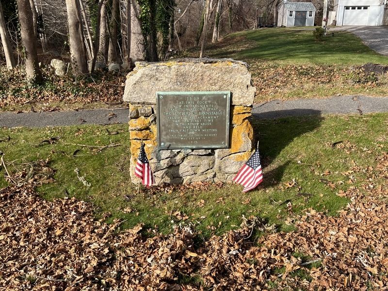
1639
At This Rock
Now In Fragments
Tradition Reports That
The Settlers of Barnstable
Received The Sacrament
For The First Time
In Their New Abode
And Held
Their First Town Meeting
This Tablet to Their Memorty
Was Set Up In
1916 — — Map (db m187512) HM
Original Settler with the Barnstable Colony in 1640.
Selected Grand Juror, Hayward, Constable, and Highway
Surveyor. Served with Militia of the Colony of New
Plymouth. In 1658, he built and operated one of the
First Grist Mills in . . . — — Map (db m140492) HM
This Boulder
Is Erected as a Memorial to
Elder Thomas Dimmock
Who with
Rev. Joseph Hull
Received the Charter for the Land
Now Occupied by the
Town of Barnstable
On This Knoll
He Built a Fortification House in 1643
Barnstable . . . — — Map (db m190896) HM
North of here a
Tablet marks the
Grave of
Iyanough
Indian Sachem who
Aided the Pilgrims
in 1621. From him
Hyannis and Wianno
derived their names. — — Map (db m190890) HM
James Otis Jr.
The Patriot
West Barnstable
1725 — 1783
Advocate Orator Statesman
President John Adams Said In Part
Of Otis’s Famous Writs Of Assistance
Speech In Boston February 1761
“American Independence . . . — — Map (db m142330) HM
Erected to the memory of
Rev. John Lothrop
1584 — 1653
And Such First Settlers Who Fill
Unmarked Graves in this Cemetery
And at the “Calves Pasture”
Mr. Lothrop Was Pastor of the
Church of England at Egerton, 1611 - 1623
The . . . — — Map (db m190420) HM
Sandwich Monthly Meeting of Friends, established in 1657, is the
oldest continuous Quaker meeting in North America. It consists
of congregations here, in West Falmouth and in Yarmouth.
This meetinghouse, the third on this site, was built . . . — — Map (db m140503) HM
You are standing where, on September 27, 1774, Cape Cod won its independence from the British without a shot fired.
The Province of Massachusetts Bay had been self-governing since its creation. But to punish it for the Boston Tea Party the . . . — — Map (db m191121) HM
Burying Hill
site of the
First
Meeting House
for
Indians
in
The Plymouth Colony
established by
Richard Bourne
and
Thomas Tupper
soon after their settlement in sandwich
1637
By their influence peace was preserved . . . — — Map (db m194894) HM
(Front)
Here lies buried
Dr. Samuel Lord
who died of smallpox
after devoted service
to the citizens of
Chatham in the
epidemic of
1765 – 1766
(Back)
This monument was erected by
the Town of Chatham in . . . — — Map (db m160407) HM
The first European to land on the shores of Chatham was Samuel de Champlain, who took refuge in Stage Harbor in October, 1606. Although relations with the Natives were initially friendly, after about ten days tensions increased and a battle . . . — — Map (db m158345) HM
He came from Norwich England in 1637. He acquired from the Indians by a series of purchases prior to the year 1683 the greater part of the present Township then known as Monomoyick. He and his sons and sons-in-laws Robert Nickerson • Samuel . . . — — Map (db m68997) HM
The house of William Nickerson built about 1664, stood south 51 degrees west at a distance of 19 1/5 rods (about 105 yards) from this marker. He was the first settler in Monomoit where he purchased from the Indians most of what is now Chatham. . . . — — Map (db m157368) HM
The Josiah Mayo House sits along Main Street across from the Town Hall, as it has since it was built nearly 200 years ago by Josiah himself, a blacksmith who came to town from Brewster. Although it’s been moved on the site – it originally . . . — — Map (db m166801) HM
The first successful cranberry cultivation occurred in this neighborhood at the Henry Hall Farm in 1816.
Dedicated by a grateful Cranberry Industry. — — Map (db m194818) HM
This is the site of the original Congregational Church in Eastham and in this churchyard are the marked graves of three Mayflower passengers.
Lt. Joseph Rogers 1608-1678
Constance Hopkins 1605-1677
Giles Hopkins 1607-1690
The successive . . . — — Map (db m244137) HM
One mile west of this site
hostile Indians had their
First Encounter
6 December 1620
(Old Style)
With Myles Standish, John Carver,
William Bradford, Edward Winslow.
John Tilley, Edward Tilley, John
Howland, . . . — — Map (db m141405) HM
On this spot hostile Indians had their first encounter December 8, 1620, old style, with Myles Standish, John Carver, William Bradford, John Tilley, Edward Winslow, John Howland, Edward Tilley, Richard Warren, Stephen Hopkins, Edward Dotey, John . . . — — Map (db m51139) HM
Near this site the Nauset tribe of the Wampanoag nation, seeking to protect themselves and their culture, had their first encounter, 8 december 1620, with Myles Standish, John Carver, William Bradford, Edward Winslow, John Tilley, Edward Tilley, . . . — — Map (db m51142) HM
The history of the town of Orleans is closely linked to the town of Eastham, and has deep roots in the original Plymouth Colony established in 1620. For some time, the colonists there had considered moving the colony to a better location due to . . . — — Map (db m158924) HM
In memory of the five Mayflower passengers who died at sea and while the ship lay in Cape Cod Harbour
William Butten Nov 16th, 1620
Edward Thomson Dec 14th, 1620
Jasper More Dec 16th, 1620
Dorothy Bradford Dec 17th, 1620
James Chilton . . . — — Map (db m234955) HM
This memorial stone is erected by the Commonwealth of Massachusetts to commemorate the Compact, or Constitution of Government, signed by the Pilgrims, on board the Mayflower in Provincetown Harbor, November 11, 1620, old style.
On the reverse . . . — — Map (db m234505) HM
On November 20, 1620 the Pilgrims dropped the Mayflower’s anchor for the first time in the new world- not at Plymouth where they later settled, but in the harbor ahead. Just off the shores of today’s Provincetown they drafted and signed a pioneering . . . — — Map (db m111673) HM
Thomas Dexter began building gristmills on this site in 1637.
The mill you see here today started operating in about 1654.
The early settlers of Sandwich brought their corn to “The Grist Mill”
to be ground into meal, . . . — — Map (db m140436) HM
Edmond Freeman Born in England 1590 Died in Sandwich 1682 A Founder of the Town of Sandwich in 1637 Assistant to Governor Bradford 1640 - 1647 — — Map (db m120748) HM
Sixteen Pilgrims led by Myles Standish, William Bradford, Stephen Hopkins and Edward Tilley found the precious Indian corn on this spot which they called Corn Hill, November 16, 1620.
Old style.
And sure it was God’s good . . . — — Map (db m156633) HM
James Otis The Patriot
Born In Barnstable February 5 1724
To Mark The Spot
Where Her Gifted Son First Saw The Light
The Town Of Barnstable
Has Placed This Boulder Upon Ground Which
Formed A Part Of The Otis Homestead And
Was Deeded To the . . . — — Map (db m187508) HM
Ancient Cemetery
Seventeenth Century Burial Ground
For the First English Settlers of
The South Side of This Town, Near
The Site of a Pre-Historic
Native American Burial Ground — — Map (db m158348) HM
Near this spot stood the first court house of Berkshire County erected 1764. Here August 16, 1774 occurred the first open resistance to British rule in America — — Map (db m58957) HM
Fifty feet to the east stood the
First Meeting House
of the
Town of Great Barrington
then known as
Upper Ousatonuck.
Erected 1742, it was used many years for the
public worship of God, and as the Town House.
"Our Fathers' God. We . . . — — Map (db m196001) HM
This Tablet
On the Original Steps of Marble from Lanesborough Quarries
Marks the Site of
The First and Second Meeting Houses
of the
First Church of Christ in Lanesborough
Organized March 28, 1764.
“I have reared me a monument . . . — — Map (db m85177) HM
On this site, in the log house of Peter Wilcox, was held
the first town meeting – Dec. 26, 1777.
The following men were elected to office.
“Moderator – William Ingersoll
Clerk – Prince West. These two, and Oliver . . . — — Map (db m86710) HM
On July 11, 1774, the people of New Marlborough Township assembled in their first Meeting-House here to record their opposition to certain acts of the British Parliament. On that day – nearly a year before the Battle of Bunker Hill – . . . — — Map (db m136846) HM
New Boston
Settled 1751
Founded along the Farmington River by the Dantel Brown family of Boston. Smiths, Demings, Hawley and sears were also early farming settlers. The Browns established the New Boston Inn a store and mills.
The village was . . . — — Map (db m97508) HM
Site of first cabin built by Isaac Stratton in 1762; first tavern, built by Samuel Sloan in 1767; town meetings in second story hall built by John Jordan in early 1830's. — — Map (db m118574) HM
This Memorial Tower marks the spot where stood the Little Church in the wilderness in which John Sergeant preached to the Stockbridge Indians in 1739. — — Map (db m59227) HM
The northerly part of this house is one of the earliest extant structures in town. Built about 1767 in "regulation" size, it was enlarged to become a salt box. In the mid-1970's it was completely rebuilt and enlarged to its present form. — — Map (db m118658) HM
Built in 1756 on this house-lot Number Six under decree of the Great and General Court of the Province of the Massachusetts Bay in compliance with urgent appeal from the homesteaders it served as sole refuge from their allied foes the French and . . . — — Map (db m118713) HM
Built 1772 as a farmhouse and tavern. Benedict Arnold slept here May 6, 1775 enroute to help Ethan Allen take Fort Ticonderoga. Bread baked here for Battle of Bennington, Aug. 16, 1777. — — Map (db m118657) HM
Built in 1768 and removed in 1797 to make way for the second Meeting House, completed 1798 and destroyed by fire January 21, 1866. — — Map (db m118715) HM
Built in March 1756, as westernmost stockade and blockhouse to protect Massachusetts from French and Indian attack. Defended on July 11, 1756 despite the scalping of three soldiers. — — Map (db m118714) HM
Original Williams College building, completed in 1790 as a free school under bequest of Col. Ephraim Williams, killed at Battle of Lake George, Sept. 8, 1755, and for whom Williamstown is named. The free school became Williams College in 1793. — — Map (db m118584) HM
For thirty six years (1647-1683) prominent in the affairs of the town of Rehoboth: representing the town in the house of deputies in the Plymouth Colony: when these lands were bought from Wamsutta Chief Sachem of the Wampanoags (1661) he was active . . . — — Map (db m57929) HM
The building of this church began in 1770 on the eastern edge of the Great Cornfield of the Pocanocket Indians. Construction was halted during the American Revolution and the church was used as soldiers farmed and sheepfold. Completion was in 1798. . . . — — Map (db m66342) HM
An ancient Indian trail. The Post Road between Massachusetts Bay and Narragansett Bay.
The first highway in Easton.
The Old Bay Road Historical District
Recorded in the National Register of Historic Places
U.S. Department of Interior . . . — — Map (db m56302) HM
Built for harbor defense in 1775. Destroyed by the British September 6th 1778. Later rebuilt and now the property of the town of Fairhaven. — — Map (db m52383) HM
The view down Centre Street has changed little over the years, and no street in New Bedford served the whaling industry longer. Little finery can be seen in the facades of these buildings, for this was a working waterfront, where utility overrode . . . — — Map (db m58182) HM
Near this spot in 1767 the first ship built in New Bedford was launched.
The Dartmouth
Francis Rotch, Owner
She was one of the vessels boarded by the Boston Tea Party in 1773
— — Map (db m58183) HM
Circa 4000BC
Natives of this area made tools from red felsite rock.
1669-1771
The Allen, Capron and Mann families owned this property. The Mann family burial ground still remains close by.
1772
Stephan Draper built a homestead . . . — — Map (db m57747) HM
Top PlaqueThis marker
is given by Massachusetts Society
Daughters of the American Colonists
in recognition of
The role this historic building played
in the area's early growth
presented: September 13 1969 Bottom Plaque . . . — — Map (db m55680) HM
The First Burial Ground is the presumed buying place of Norton's pioneer settler's.
William Witherell, who died in September 1691, is buried in the West end of the burial ground. When the land was passed to Nathaniel Witherell by his father,the . . . — — Map (db m52379) HM
The Native American Sachem, Metacomet of Pokonoket, called King Philip by the English, Sachem or chief of the Wampanoag people is reported to have used this area as a stopping place. It provided a natural fortress for his many visits to the . . . — — Map (db m56217) HM
The land which comprises this cemetery dates back to June 1702, and is the original town common. Originally called "The Common," this land consisting of approximately five acres, is the first land set apart for common use in Norton. Situated on the . . . — — Map (db m56462) HM
This historic area along Stony Brook was named Chartley before 1700. The name is thought to be related to the iron business, which thrived in this area.
In 1695, the Taunton North Purchase granted to Thomas and James Leonard land along the . . . — — Map (db m55989) HM
Winneccunnett Pond is the only sizable, natural body of water in Norton, Massachusetts. Winneccunnett is a Native American word meaning "the place of the black geese." A Native American village was established on the north end of the pond long . . . — — Map (db m56459) HM
Built by James Leonard
Originally owned by twenty-three
of Taunton's first settlers
Operated 1777 to 1876 by
Hon. Josiah Dean
and his descendants as sole owners
Erected 1950
by Bertha Dean
Adelaide Lord Livingstone
Daughter and . . . — — Map (db m87253) HM
Former site of the Anawan House, once called the Lewis Tavern built ca. 1835 as a rest stop for travelers between Taunton and Providence Plantations.
The Anawan House and inn served the public until July 1970. In February 1971 the building was . . . — — Map (db m55683) HM
Site of capture of the Wamponoag Indian Chief Anawan by Captain Benjamin Church on August 28th 1676, thus ending King Philip's war — — Map (db m44921) HM
The name "Bad Luck" (origin unknown) has been associated with this area since the early 1700's. The Beverly and Kelton families operated a water powered saw mill for many years on the North side of the pond beginning in the 18th century.
Bad Luck . . . — — Map (db m56246) HM
In 1720, Jonathan Bliss moved here from South Rehoboth and established a sawmill on the East Branch of the Palmer River with a homestead nearby. This homestead was one of the first in the area, and Bliss called it " my farm in the woods" the mill . . . — — Map (db m56247) HM
When the British occupied Newport, RI. during the Revolution they often threatened the surrounding towns with raids or "alarums" as they were called. When a raid began a system of beacon fires were lit to warn the militia in neighboring towns to . . . — — Map (db m55911) HM
Nearby runs Mine Brook named after an iron mine established here in 1696 by the Leonards, a famous iron monger family from Norton and Taunton.
The ore dug at this site called bog iron, was found in the swamp and brook. The Leonards hauled the ore . . . — — Map (db m55679) HM
During the American Revolution, a large white oak called "the Liberty Tree" stood near this place, which was then near the edge of a field. Beacons warning of trouble in Rhode Island could be seen by watchers at nearby Horton's Signal. After . . . — — Map (db m55918) HM
This town pound maintained by Col. Frederick Drown for many years. Stray cattle were kept here until retrieved by their owners.
The Wheeler family ran a pot ash business nearby. — — Map (db m55912) HM
It was known as Butterworth Falls in the colonial days. Deacon Thomas Carpenter and later the Perry family maintained the saw-gristmill-turning shop here for almost 200 years — — Map (db m55686) HM
Redway Plain is named after James Redway, who settled here in the early 1700's. Originally the plain included this field, The Faxon Farm Field,and the Village Cemetery. Neither Winthrop Street or Pond Street existed before 1828.
From colonial . . . — — Map (db m56243) HM
Founded by Josiah Millerd in 1731. For over 140 years neighborhood farmers had their corn ground into meal and their logs sawn into lumber at this mill. — — Map (db m55917) HM
Framing for this church had begun at Peckham Street, when disgruntled Oak Swamp people took away the timbers in the night and raised the church here. — — Map (db m55913) HM
Site of "The Palmer's River Meeting House" The first meeting house in the second precinct of Rehoboth. Construction started in 1717 and completed November 29th 1721, with Reverend David Turner as pastor. Fifty pounds was donated towards the cost of . . . — — Map (db m55662) HM
King’s Rock, spanning 200 ft. along today’s Warren/Swansea border, was a significant location along the route and an important place for tribal gatherings under Metacom’s older brother, Wamsutta. Tribes from all over New England were known to have . . . — — Map (db m235790) HM
Near this spot stood the John Myles Garrison House. The place of meeting of the troops of Massachusetts Bay and Plymouth colonies.
Commanded by
Majors Thomas Savage and James Cudworth, who marched to the relief of Swansea at the opening of . . . — — Map (db m56215) HM
Near this elm tree stood the first school house build 1637
Tree Planted and tablet place by the Lydia Cobb Chapter of the Daughters of the American Revolution Tercentenary of Taunton 1639-1939 — — Map (db m55658) HM
Born in Africa, and enslaved in Chilmark. She married Elisha Amos, a Wampanoag man. She was the mother of Nancy Michael. Rebecca died a free woman in this place in 1801. — — Map (db m85500) HM
This rock marks the “place on the wayside” where the Rev. Thomas Mayhew Jr., son of Gov. Mayhew, First pastor of the Church of Christ on Martha’s Vineyard, and the first missionary to the Indians of New England, solemnly and affectionately . . . — — Map (db m178097) HM
Thomas Macy, first town clerk of Amesbury, erected this house prior to 1654. Persecuted for harboring Quakers he sold the house and fled to Nantucket, becoming the first white settler as related in Whittier's poem "The Exiles." — — Map (db m48772) HM
This cemetery is the family burial ground for the Woodbridge and Jenkins families. The burial ground and adjacent historic 1765 Benjamin Jenkins' farmstead date from the late 18th century colonial period. Colonel Benjamin Jenkins was a . . . — — Map (db m243104) HM
Built in 1638 by John Balch, who came over in 1623 with Captain Robert Gorges. The "Old Planters" received this land in exchange for their settlement at Salem. — — Map (db m47949) HM
Roger Conant was a prudent and religious man who led the old planters from Gloucester
to Salem in 1626, and held them together until the Bay Colony was founded. This house was
built on land given by him to his son Exercise Conant in 1666. — — Map (db m47357) HM
This house was built in 1694 by the Rev. John Hale, first minister of the first church in Beverly. A charge of witchcraft made against his wife convinced the minister of the folly and wickedness of the crusade and ended all witch-hunting in . . . — — Map (db m48760) HM
The old planters, Roger
Conant, John Woodbery and
John Balch used this path
from their homesteads to the
cove at the head of Bass river. — — Map (db m47401) HM
656 entries matched your criteria. The first 100 are listed above. Next 100 ⊳