After filtering for New Hampshire, 96 entries match your criteria.
Colonial Era Topic
By Kelly Marsh, September 9, 2023
Jonathan Chesley Marker
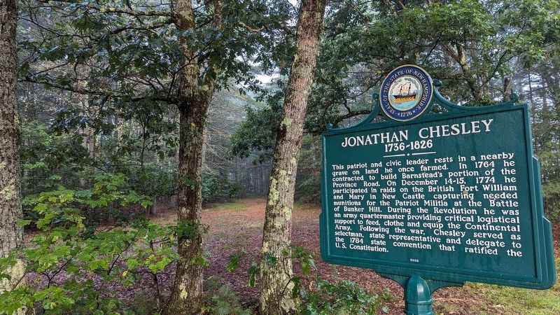
| 1 ► New Hampshire, Belknap County, Barnstead — 0201 — Jonathan Chesley — 1736 - 1826 — |
| On S Barnstead Road (New Hampshire Route 126) north of Gray Road, on the left when traveling north. | |||
| 2 ► New Hampshire, Belknap County, Gilmanton — 017 — Old Province Road — |
| On New Hampshire Route 107, on the right when traveling north. | |||
| 3 ► New Hampshire, Belknap County, Laconia — Ancient and Honorable Artillery Company — 1637 - 1774 — |
| Near Endicott Street (U.S. 3) east of Lakeside Avenue, on the right when traveling west. | |||
| 4 ► New Hampshire, Belknap County, Laconia — Endicott Rock — |
| On Endicott Street (U.S. 3) east of Lakeside Avenue, on the right when traveling west. | |||
| 5 ► New Hampshire, Carroll County, Chocorua — 31 — The Chocorua Legend — |
| On Chocorua Mountain Highway (New Hampshire Route 16) 0.8 miles north of Chocorua Lake Road, on the left when traveling north. | |||
| 6 ► New Hampshire, Carroll County, Hart's Location — 186 — Sawyer's Rock — |
| On Crawford Notch Road (U.S. 302) west of White Mountain Road (New Hampshire Route 16), on the right when traveling east. | |||
| 7 ► New Hampshire, Carroll County, Ossipee, Center Ossipee — 20 — Captain Lovewell's War — |
| On White Mountain Highway (New Hampshire Route 16) at New Hampshire Route 16B, on the right when traveling north on White Mountain Highway. | |||
| 8 ► New Hampshire, Carroll County, Wolfeboro — 116 — College Road — |
| On North Main Street (New Hampshire Route 109) at Lang Pond Road, on the right when traveling north on North Main Street. | |||
| 9 ► New Hampshire, Cheshire County, Chesterfield, West Chesterfield — 060 — First Methodist Meeting Place In New Hampshire — |
| On Franklin Pierce Highway (New Hampshire Route 9) at Pond Brook Road, on the right when traveling west on Franklin Pierce Highway. | |||
| 10 ► New Hampshire, Cheshire County, Fitzwilliam — Brigadier General James Reed — |
| On New Hampshire Route 119 at Templeton Turnpike, on the left when traveling south on State Route 119. | |||
| 11 ► New Hampshire, Cheshire County, Fitzwilliam — 99 — Brigadier General James Reed — (1722-1807) — |
| On New Hampshire Route 119 west of Templeton Turnpike, on the left when traveling west. | |||
| 12 ► New Hampshire, Cheshire County, Keene — Deacon Josiah Fisher — |
| Near West Street at Federal Street. | |||
| 13 ► New Hampshire, Cheshire County, Keene — Keene Remembers — |
| On Main Street at Roxbury Street, in the median on Main Street. | |||
| 14 ► New Hampshire, Cheshire County, Keene — Nathan Blake — |
| On Main Street at Winchester Street, on the right on Main Street. | |||
| 15 ► New Hampshire, Cheshire County, Keene — The First Meeting House in Upper Ashuelot — |
| On Main St. (New Hampshire Route 12) 0.1 miles north of Rte. 101E and Hwy. 12, on the right when traveling south. | |||
| 16 ► New Hampshire, Cheshire County, Keene — The Old Fort — |
| On Main Street (New Hampshire Route 12) north of Gates Street, on the right when traveling north. | |||
| 17 ► New Hampshire, Cheshire County, Walpole — John Kilburn Cabin — |
| On New Hampshire Route 12, 0.9 miles north of Upper Walpole Road, on the right when traveling north. | |||
| 18 ► New Hampshire, Coos County, Pinkham's Grant — 011 — First Ascent of Mount Washington — |
| On New Hampshire Route 16 at milepost 99.6,, 10 miles south of Main Street (U.S. 2), on the left when traveling south. | |||
| 19 ► New Hampshire, Grafton County, Bath — 121 — Bath, New Hampshire — |
| On Rum Hill Road (U.S. 302), on the right when traveling south. | |||
| 20 ► New Hampshire, Grafton County, Canaan — Canaan Street — |
| On Church Street (Route 4) at Canaan Street (U.S. 4), on the left when traveling east on Church Street. | |||
| 21 ► New Hampshire, Grafton County, Enfield — The Enfield Shakers — |
| On New Hampshire Route 4A at Caleb Dyer Lane, on the right when traveling south on State Route 4A. | |||
| 22 ► New Hampshire, Grafton County, Franconia — A Bit of History — |
| On U.S. 3. | |||
| 23 ► New Hampshire, Grafton County, Franconia — Why is it called A NOTCH? — |
| Near U.S. 93. | |||
| 24 ► New Hampshire, Hillsborough County, Bedford — 102 — Colonel John Goffe — (1701 - 1786) — |
| On South River Road (U.S. 3) 0.1 miles south of Kilton Road, on the right when traveling south. | |||
| 25 ► New Hampshire, Hillsborough County, New Boston — 0146 — Home of the Molly Stark Cannon — |
| 26 ► New Hampshire, Hillsborough County, Temple — 0012 — Temple Glass Factory — |
| On Gen. Miller Highway. | |||
| 27 ► New Hampshire, Hillsborough County, Weare — Pine Tree Riot — |
| On South Stark Highway (New Hampshire Route 114) 0.1 miles south of Orchard Hill Road, on the right when traveling south. | |||
| 28 ► New Hampshire, Hillsborough County, Weare — Site of Pine Tree Tavern — 1772 • 1928 — |
| On South Stark Highway (New Hampshire Route 114) 0.1 miles south of Orchard Hill Road, on the right when traveling south. | |||
| 29 ► New Hampshire, Merrimack County, Boscawen — 0049 — Hannah Dustin — 1657 - 1737 — |
| On King Street (U.S. 4), on the right when traveling east. | |||
| 30 ► New Hampshire, Merrimack County, Boscawen — Heroum Gesta — Fides Justitia — |
| On King Street (U.S. 4), on the right. | |||
| 31 ► New Hampshire, Merrimack County, Canterbury — Henry Parkinson, A. M. — |
| On NW Road (Route 132) 0.1 miles south of Rum Brook Road, on the right when traveling south. | |||
| 32 ► New Hampshire, Merrimack County, Concord — Eastman — |
| On Eastman Street at Portsmouth Street, on the right when traveling north on Eastman Street. | |||
| 33 ► New Hampshire, Merrimack County, Concord — First Session of the Legislature at Concord — |
| On North Main Street south of Horseshoe Pond Lane, on the left when traveling north. | |||
| 34 ► New Hampshire, Merrimack County, Concord — Main Street's Origins — Downtown Concord — Est. 1725 — |
| On North Main Street (U.S. 3) at Capitol Street, on the right when traveling north on North Main Street. | |||
| 35 ► New Hampshire, Merrimack County, Concord — On The Interval Below This Spot — |
| On East Side Drive (New Hampshire Route 132), on the right when traveling south. | |||
| 36 ► New Hampshire, Merrimack County, Concord — 110 — Ratification of the Federal Constitution — |
| On Bouton Street (U.S. 3) at Church Street, on the right when traveling south on Bouton Street. | |||
| 37 ► New Hampshire, Merrimack County, Concord — Site of First Block House — |
| On North Main Street (U.S. 202) at Chapel Street, on the right when traveling south on North Main Street. | |||
| 38 ► New Hampshire, Merrimack County, Concord — Site of First Ferry — |
| On Eastman Street, on the right when traveling north. | |||
| 39 ► New Hampshire, Merrimack County, Concord — Site of Rumford Garrison No. 2 — |
| On Eastman Street, 0.1 miles north of Portsmouth Street, on the left when traveling north. | |||
| 40 ► New Hampshire, Merrimack County, Concord — Site of Rumford Garrison No. 5 — |
| On North Main Street (U.S. 3) at Loudon Road, on the right when traveling north on North Main Street. | |||
| 41 ► New Hampshire, Merrimack County, Concord — Site of Rumford Garrison No. 6 — |
| On Hall Street at Water Street (U.S. 3) on Hall Street. | |||
| 42 ► New Hampshire, Merrimack County, Concord — Site of Rumford Garrison No. 7 — |
| On South Main Street (U.S. 3) at Wentworth Ave. (Private), on the right when traveling south on South Main Street. | |||
| 43 ► New Hampshire, Merrimack County, Concord — The First Garrison in Concord — |
| On North Main Street, 0.2 miles north of U.S. 202, on the right when traveling north. | |||
| 44 ► New Hampshire, Merrimack County, Concord — 0238 — The Pennacook — |
| On College Drive, on the right when traveling north. | |||
| 45 ► New Hampshire, Merrimack County, Concord — This Monument is in Memory of Samuel Bradley — |
| On Pleasant Street (U.S. 202), on the right when traveling west. | |||
| 46 ► New Hampshire, Merrimack County, Dunbarton — 0111 — Molly Stark House — |
| On Stark Highway South (New Hampshire Route 13) at New Hampshire Route 77, on the right when traveling south on Stark Highway South. | |||
| 47 ► New Hampshire, Merrimack County, Franklin — 0091 — Birthplace of Daniel Webster — |
| On North Road, 0.7 miles north of Salisbury Road (New Hampshire Route 127), on the right when traveling north. | |||
| 48 ► New Hampshire, Merrimack County, Franklin — Philip Call — First White Settler of Franklin, N.H. — |
| On S Main Street (U.S. 3) 0.5 miles south of Holy Cross Road, on the left when traveling north. | |||
| 49 ► New Hampshire, Merrimack County, Hopkinton, Contoocook — Woodwell's Garrison 1744 — |
| On Indian Ridge Road. | |||
| 50 ► New Hampshire, Merrimack County, Pembroke — 0144 — First Meeting House — |
| On Pembroke Street (U.S. 3), on the right when traveling south. | |||
| 51 ► New Hampshire, Rockingham County, Chester — The Chester Congregational Church — |
| On Chester Street (New Hampshire Route 121) at Raymond Road (New Hampshire Route 102), on the left when traveling east on Chester Street. | |||
| 52 ► New Hampshire, Rockingham County, Exeter — 131 — Brigadier General Enoch Poor — |
| On Newfields Road (New Hampshire Route 85), on the right when traveling north. | |||
| 53 ► New Hampshire, Rockingham County, Exeter — Exeter NH Folsom and Gilman Marker — |
| On Drinkwater Road at Rt. 111, in the median on Drinkwater Road. | |||
| 54 ► New Hampshire, Rockingham County, Exeter — 097 — Exeter Town House — |
| On Front Street at Court Street, on the right when traveling north on Front Street. | |||
| 55 ► New Hampshire, Rockingham County, Exeter — 161 — Ladd-Gilman House — |
| On Water Street, on the right. | |||
| 56 ► New Hampshire, Rockingham County, Exeter — Powder House — — 1771 — — |
| Near Jady Hill Avenue. | |||
| 57 ► New Hampshire, Rockingham County, Exeter — Powder House — — 1771 — — |
| On Swasey Parkway, on the right when traveling north. | |||
| 58 ► New Hampshire, Rockingham County, Exeter — 032 — Revolutionary Capital — |
| On Front Street, on the right when traveling north. | |||
| 59 ► New Hampshire, Rockingham County, Exeter — Second Burial Ground — |
| Near Newfields Road. | |||
| 60 ► New Hampshire, Rockingham County, Exeter — Site of the First Mill At Falls of the Squamscott River — |
| On String Bridge, on the right when traveling south. | |||
| 61 ► New Hampshire, Rockingham County, Fremont — Historic Black Rocks Village / Historic Fremont, N.H.-Olde Poplin — |
| On Main Street (New Hampshire Route 107) south of Sandown Road, on the right when traveling south. | |||
| 62 ► New Hampshire, Rockingham County, Fremont — John Prescott Lovering's Inn — circa 1756 — |
| On Main Street (New Hampshire Route 107) at Sandown Road, on the right when traveling north on Main Street. | |||
| 63 ► New Hampshire, Rockingham County, Fremont — 142 — Mast Tree Riot of 1734 — |
| On Main Street (New Hampshire Route 107) at New Hampshire Route 111-A, on the right when traveling north on Main Street. | |||
| 64 ► New Hampshire, Rockingham County, Greenland — 480 Portsmouth Avenue — Town of Greenland — Incorporated 1721 |
| On Portsmouth Avenue at Post Road (New Hampshire Route 151), on the right when traveling west on Portsmouth Avenue. Reported damaged. | |||
| 65 ► New Hampshire, Rockingham County, Greenland — Congregational Church — Greenland, N.H. — |
| On Church Lane (New Hampshire Route 151) just south of Portsmouth Avenue, on the right when traveling south. | |||
| 66 ► New Hampshire, Rockingham County, Hampton — 0028 — First Public School Marker — |
| On Winnacunnet Road, on the left. | |||
| 67 ► New Hampshire, Rockingham County, Kingston — 046 — Josiah Bartlett — — 1729–1795 — — |
| On West Main Street, on the right when traveling north. | |||
| 68 ► New Hampshire, Rockingham County, New Castle — Frost Cemetery — |
| On Main Street (Route 1B) east of Atkinson Street, on the left when traveling east. | |||
| 69 ► New Hampshire, Rockingham County, Newington — Bloody Point Ferry — |
| On Shattuck Way north of Bloody Point Road, on the right when traveling north. | |||
| 70 ► New Hampshire, Rockingham County, Newington — 0151 — Newington — |
| On General Sullivan Bridge at Shattuck Way, on the left when traveling north on General Sullivan Bridge. | |||
| 71 ► New Hampshire, Rockingham County, Newmarket — Wentworth Cheswill — (1746–1817) — |
| On South Main Street (New Hampshire Route 152) west of Packers Falls Road. | |||
| 72 ► New Hampshire, Rockingham County, Nottingham — 0259 — Nottingham Square — |
| On Raymond Road (New Hampshire Route 156) at Ledge Farm Road, on the right when traveling north on Raymond Road. | |||
| 73 ► New Hampshire, Rockingham County, Portsmouth — African Burying Ground Memorial — |
| On State Street (U.S. 1) east of Middle Street, on the right when traveling east. | |||
| 74 ► New Hampshire, Rockingham County, Portsmouth — Black Yankees and The Sea — Portsmouth Black Heritage Trail — |
| Near Marcy Street east of Puddle Lane, on the right when traveling north. | |||
| 75 ► New Hampshire, Rockingham County, Portsmouth — Horse Chestnut — Aesculus hippocastanum — |
| On Market Street, on the right when traveling south. | |||
| 76 ► New Hampshire, Rockingham County, Portsmouth — Joseph & Nancy (Cotton) and their children, Eleazor & James — Portsmouth Black Heritage Trail — |
| On State Street (U.S. 1) at Court Place, on the right when traveling north on State Street. | |||
| 77 ► New Hampshire, Rockingham County, Portsmouth — Liberty Pole and Bridge — |
| On Marcy Street. | |||
| 78 ► New Hampshire, Rockingham County, Portsmouth — Oracle House — Circa 1702 — |
| On Marcy St. at Court St., on the right when traveling south on Marcy St.. | |||
| 79 ► New Hampshire, Rockingham County, Portsmouth — Pleasant Street — |
| On Pleasant Street at Washington Street, on the left when traveling west on Pleasant Street. | |||
| 80 ► New Hampshire, Rockingham County, Portsmouth — Point of Graves — |
| On Mechanic Street. | |||
| 81 ► New Hampshire, Rockingham County, Portsmouth — Site of "Negro Burying Ground" — Portsmouth Black Heritage Trail — |
| On State Street (U.S. 1) east of Middle Street, on the right when traveling east. | |||
| 82 ► New Hampshire, Rockingham County, Portsmouth — The Original New Hampshire State House — |
| On Congress Street just west of Pleasant Street. | |||
| 83 ► New Hampshire, Rockingham County, Rye — 018 — Isles Of Shoals — |
| Near Ocean Boulevard (Route 1A). | |||
| 84 ► New Hampshire, Rockingham County, Seabrook — 0120 — Bound Rock — |
| On Woodstock Street west of Ocean Drive, on the left when traveling west. | |||
| 85 ► New Hampshire, Rockingham County, Seabrook — 103 — Shapley Line — |
| On Lafayette Road (U.S. 1) at Rocks Road, on the right when traveling north on Lafayette Road. | |||
| 86 ► New Hampshire, Strafford County, Barrington — 0279 — The Balch Household Graves — |
| On Franklin Pierce Highway (New Hampshire Route 9) 0.1 miles east of Oak Hill Road, on the right when traveling east. | |||
| 87 ► New Hampshire, Strafford County, Dover — 2 — Dover's Early Settlers — The Cochecho Massacre — |
| On Central Avenue (New Hampshire Route 9) south of First Street, on the right when traveling south. | |||
| 88 ► New Hampshire, Strafford County, Dover — 0051 — Dr. Jeremy Belknap (1744 - 1798) — |
| On Boston Harbor Road. | |||
| 89 ► New Hampshire, Strafford County, Dover — 0264 — Home of John Parker Hale — 1840-1873 — |
| On Central Avenue at Summer Street, on the right when traveling south on Central Avenue. | |||
| 90 ► New Hampshire, Strafford County, Durham — 89 — Major General John Sullivan — 1740-1795 — |
| On Newmarket Road (New Hampshire Route 108), on the left when traveling west. | |||
| 91 ► New Hampshire, Strafford County, Durham — Major General John Sullivan Memorial — |
| On Newmarket Road. | |||
| 92 ► New Hampshire, Strafford County, Durham — 0154 — Packer's Falls — |
| On New Hampshire Route 108 near Route 108. | |||
| 93 ► New Hampshire, Strafford County, New Durham — New Durham Meeting House — |
| On New Hampshire Route 11, on the right when traveling north. | |||
| 94 ► New Hampshire, Strafford County, Rollinsford — David Hamilton of Westburn — |
| On Sligo Road at Pinch Hill Road, on the right when traveling north on Sligo Road. | |||
| 95 ► New Hampshire, Sullivan County, Charlestown — Liberty Tree Memorial — |
| On Main Street (New Hampshire Route 12) north of Olcott Lane, on the left when traveling north. | |||
| 96 ► New Hampshire, Sullivan County, North Charlestown — North Charlestown Village — |
| On River Road (SR 12A) at Depot Hill Road on River Road (SR 12A). | |||