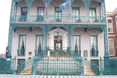
This house, built before the American Revolution, was the residence of John Rutledge (1739-1800), first Governor of the State of South Carolina. He was President of South Carolina, 1776-78, and Governor, 1779-82, signer of the U. S. Constitution, . . . — — Map (db m27466) HM
This land, granted 1680 to John Coming, is part of the glebe given in 1698 to the English Church by Mrs. Affra Coming. The provincial library established in 1698 was in St. Philip’s Church Parsonage which stood on this site until 1858 when a girls’ . . . — — Map (db m141259) HM
This church grew from services held for German inhabitants in Charleston by Rev. Johann Martin Boltzius in 1734 and Rev. Henry Melchior Muhlenberg in 1742. The cornerstone of the first house of worship was laid in 1759; the second and present church . . . — — Map (db m11228) HM
Private residence, built before 1728 by William Harvey. This house was leased 1750 by his Excellency James Glenn, Governor of the Province until purchased in 1756 by Ralph Izard planter. A century later, 1858, Izard descendants sold it to Judge . . . — — Map (db m27470) HM
This residence is one of the earliest wooden houses in Charleston. It is built of black cypress and was definitely standing in 1755, but could possibly have been constructed as early as 1721. The lot was granted by the King of England to John . . . — — Map (db m240669) HM
↑ Fort Moultrie 1776 First complete victory in Revolution ↑ Fort Sumter 1829 Longest Siege in warfare 1863-186 ↑ Fort Johnson 1704 First shot in Civil War ← Castle Pickney 1794 ← Cooper River Formerly Wando . . . — — Map (db m67961) HM
Othneil Beale, sea Captain from New England, Colonel of Provincial Troops, Engineer, Successful merchant, built this house about 1740, with ground floors for mercantile use, and living rooms above Finely Cypress Paneled.
The previous owners, . . . — — Map (db m19665) HM
This early Georgian single house was apparently built by George Ducat, a shipwright, for his daughter Margaret, on her second marriage in 1732, to Dr. William Cleland, of Crail, Scotland. This section of Tradd Street is one of the few within the . . . — — Map (db m39321) HM
Rediscovering the Old Wall The old city wall remained buried and forgotten until traces of Granville Bastion were discovered at 40 East Bay Street in the 1920s. In the 1960s a portion of the Half Moon Battery was discovered in the basement of . . . — — Map (db m67434) HM
Standing on land bought from Robert Tradd, which was part of lot 60 of "Grand Modell" of 1672. Early Georgian house built by Jacob Motte, prominent Huguenot and one time royal treasurer of province. Original paneling from second floor living room is . . . — — Map (db m39320) HM
This property, originally known as Town Lot Number 54 of the Grand Modell of Charles Town, was granted by the Lords Proprietors to William Jones March 23, 1682. In 1808, the property was purchased by John Cordes Prioleau, a wealthy planter. Madame . . . — — Map (db m27461) HM
This Georgian style residence was built for James Laurens (1728-1784) by Charleston architect-builders Miller & Fullerton on property once part of Dr. Samuel Carne's 18th century orange garden. Laurens was a Charleston merchant and the brother of . . . — — Map (db m27467) HM
One of the Founders of the American Republic
Born February 25, 1746, Charleston
Member of Provincial Assembly 1769
District Attorney General for South Carolina 1773
Member of Provincial Congress 1775
Officer of the Continental Army . . . — — Map (db m47718) HM
Peter Bocquet the younger built this house
shortly after the lot was given to him in July,
1770, by his father Peter Bocquet, senior, a
Huguenot immigrant. The younger Bocquet
became a major in the Revolutionary forces,
a member of the . . . — — Map (db m27446) HM
(West Face):
This Monument represents the high esteem in
which all who love freedom hold Charleston's
native son, William Moultrie
Born November 23, 1730, Moultrie served in
the Royal Assembly from 1752 until 1773. He . . . — — Map (db m221024) HM
Elisha Poinsett
————
Builder
His descendant,
Joel Roberts Poinsett
one time Ambassador
to Mexico, introduced
the Poinsettia
to the United States — — Map (db m50482) HM
Dr. Jean Ernest Poyas built this classic Charleston single house in elegant Adamesque style of architecture. It was purchased in 1837 by Moses Cohen Mordecai, an important historic figure, who added the piazzas and connected the main house to the . . . — — Map (db m27458) HM
Built circa 1720 for
Colonel Robert Brewton
wealthy wharf owner and
provincial powder receiver.
One of the earliest fine
examples of a
single house.
[Plaque]
Robert Brewton House
Has Been Designated a
Registered . . . — — Map (db m47642) HM
The parapet included embrasures, or splayed cannon openings, designed to provide additional “lines of fire.” Based on the 1739 illustration, each redan was armed with five to seven cannon. This section of brick parapet was pushed into . . . — — Map (db m67436) HM
Under his direction, Charleston was fortified, thereby making it one of three walled cities in North America, after Quebec, Canada and St. Augustine, Florida. As commander in chief of the armed forces, he successfully defended Charleston against a . . . — — Map (db m39219) HM
Near this spot in the autumn of 1718, Stede Bonnet, Notorious "Gentleman Pirate", and twenty nine of his men, captured by Colonel William Rhett, met their just deserts after a trial and charge, famous in American history, by Chief Justice Nicholas . . . — — Map (db m19172) HM
This Georgian double-tenement is located on part of lot number 60 of the Grand Modell, a city plan developed between 1670-1680. Lot number 60 was granted originally to Robert Tradd, after whose family Tradd Street is named. The property was . . . — — Map (db m39323) HM
Charleston shipbuilder George Ducat constructed this two-story Charleston single house shortly after purchasing the property in 1739. The house is a rare surviving example of a Charleston residence constructed partly of Bermuda stone, a coral . . . — — Map (db m39324) HM
The Plan of Charles Town
Prepared by Edward Crisp about 1704, gives the Location of the several Bastions
A. Granville
B. Craven
C. Cartaret
D. Colleton
E. Ashley
F. Blake
G. The Half Moon
I. Johnson's Cover'd Half Moon
L. The . . . — — Map (db m19231) HM
The Plan of Charles Town
Prepared by Edward Crisp about 1704, gives the
location of the several Bastions
A. Granville
B. Craven
C. Cartaret
D. Colleton
E. Ashley
F. Blake
G. The Half Moon
I. Johnson's Cover'd Half Moon
L. The . . . — — Map (db m19230) HM
Founded by French Huguenots September 1, 1737, was incorporated May 1, 1751, by the Provincial General Assembly and the Charter confirmed at the Court of St. James by George II December 20, 1752. To further the Society's activities this Hall and . . . — — Map (db m27457) HM
In 1670 English men and women established the Carolina settlement at Albemarle Point on the Ashley River, the present-day site of Charles Towne Landing State Park. Ten years later, the settlers moved their town to its location here . . . — — Map (db m62552) HM
Constructed circa 1740 by William Vanderhorst, this three story stuccoed masonry structure is considered one of the earliest examples of Charleston single house. A notable aspect of the building is the absence of a piazza, a development found in . . . — — Map (db m39326) HM
Thomas Bee, a leader in the
colonial government and
a patriot of the Revolution,
built this fine house about
1730. A later owner was
Governor Joseph Alston
and his wife, Theodosia,
daughter of Aaron Burr.
She was mysteriously lost . . . — — Map (db m47910) HM
Planter, Merchant, Surgeon, arrived in Charles Town in 1684 with his first wife, Barbara Atkins, and sons, Thomas and George. A cacique by 1690, he was created Landgrave by the Lords Proprietors on May 13, 1691. He died in his 46th year on . . . — — Map (db m19107) HM
This three-story, stucco-over brick building was constructed circa 1770 on Town Lot No. 60 of the Grand Modell of Charles Town by merchant and planter William Harvey. It was the western half of a double tenement (18th century term denoting rental . . . — — Map (db m39314) HM
You are on the site of the settlement of Charles Towne. In this place, Native Americans, English, Africans and Barbadians came together to create the first successful English colony in Carolina. Interacting with each other and the land, these . . . — — Map (db m67877) HM
Indentured servants and enslaved Africans were the backbone of the new colony, and their labor ensured its survival. Hundreds arrived in the years after 1670, and the new settlement must have included some sort of housing for this labor force. In . . . — — Map (db m67891) HM
A building of the 1670-80 settlement once stood at this spot. Its discovery by archaeologists raised many questions. What was its purpose? Who used it? What did I look like? One interpretation, based on the artifact types found here, is that it . . . — — Map (db m67924) HM
This small shed represents the construction techniques that might have been used at early Charles Towne. It is not a reconstruction of a specific building, and as far as we know there was never an actual building or garden located on this exact . . . — — Map (db m67927) HM
Seeking a place for establishing a settlement, the first colonists were directed to this site by the Chief of the Kiawah Indians. The friendly Cassique and his people greatly helped the struggling colony. This statue by Willard Hirsch commissioned . . . — — Map (db m67869) HM
Charles Towne
The first permanent English settlement in what is now S.C. was established here in 1670. Named
for King Charles II, the town was built on Albemarle Point, on the W bank of the Ashley River. It began in 1670-71 with a palisaded . . . — — Map (db m150704) HM
What constitutes a crime? In early Charles Towne, the majority of prosecuted crimes involved slander against the government, or actions that endangered the colony or threatened its profit. This differed from New England colonies, where religious or . . . — — Map (db m67892) HM
Henry Woodward played a vital role in the success of Charles Towne. He spoke several Indian languages, had lived with a Carolina tribe for almost two years and often acted as an ambassador for the colonists among the Native Americans. Without Dr. . . . — — Map (db m67906) HM
Often the details of the past are shrouded in mystery. Archeologists and historians have to weave together an interpretation based on limited evidence. In the case of this structure, archaeology revealed size but not appearance. The frame of . . . — — Map (db m67923) HM
The “motor” of a sailing ship is its masts and rigging, which hold canvas sails to catch the power of the wind. Skilled captains manipulated different sails to harness any available breeze. A favorable tailwind would fill the large main . . . — — Map (db m67959) HM
The Kiawah chief, or Cassique, invited the new English settlers to build their village here at Albemarle Point. The arrangement had immediate benefits for both the Kiawah and the English. The Kiawah often fought against the Westos, an aggressive . . . — — Map (db m67873) HM
The town of Maryville, chartered in 1886, included the site of the original English settlement in S.C. and the plantation owned by the Lords Proprietors 1670-99. When the old plantation was subdivided into lots and sold to local blacks in the 1880s, . . . — — Map (db m16283) HM
Carolina was meant to make money for the Lords Proprietors who received this land from England’s King Charles II. Across the creek from where you stand, forty acres were cleared and experimental crops were planted in a quest for agricultural . . . — — Map (db m67882) HM
War between Spain and England ended 10 years before the founding of Charles Towne, but the hatred and mistrust between the two empires remained. In an era of empire building, Charles Towne’s existence directly challenged Spain’s claim on the land . . . — — Map (db m67887) HM
Settlers came to Carolina seeking land and fortune. But fear of Spanish and Native American attacks made cautious businessmen out of them. For ten years, they postponed their dream of having a flourishing settlement at Oyster Point across the marsh . . . — — Map (db m67885) HM
“We have with much adoe, our people being weake by reason of scarcity of provisions, pallisadoed about 9 acres of land . . . ”- Council to the Lord Proprietors, 21 March 1671 The colonists were aware that the Spanish, . . . — — Map (db m67879) HM
Land abounded in the new Carolina colony. The challenge lay in finding a money-making crop and a labor force to produce it. The Lords Proprietors who funded the colony directed the colonists to experiment in order to determine which crops would . . . — — Map (db m67928) HM
Thomas Gray and John Pinkerd stood accused of “Acts of delinquency and rebellion committed in and aboard the sloop by the said Gray and his confederates.” As fugitives wanted by the Colony of Carolina, the outlaws fled Charles Towne, . . . — — Map (db m67958) HM
This ship skeleton depicts the earliest stage of shipbuilding – hull construction. It starts with the ship’s backbone, or keel, and then the stern, ribs, and sternpost are attached. This skeleton is built to the same scale as the fully . . . — — Map (db m67956) HM
Erected by The Charles Town Chapter Children of the American Revolution November 25th 1909 --------------- This block of regal blue marble from the quarries at Regal North Carolina marks the site of Old Charles Town, South Carolina. Settled by the . . . — — Map (db m67905) HM
Built in part in 1706, the year the Church of England was established here by law. Enlarged 1723. Burned out and re-built 1764. Scene of early missionary work among the Negroes. — — Map (db m242440) HM
Fearing attack, the people of Charles Towne Landing needed a defensive wall – the taller, the better. So they dug a ditch, piling the dirt along one edge. By constructing a palisade upon that heaped-up foundation, they would have forced . . . — — Map (db m67929) HM
Trade was the lifeblood of the colony, and trade was impossible without good ships. The Adventure is a replica of a 17th-century trading vessel called a ketch. Ketches and other small ships plied the waters between Carolina and other . . . — — Map (db m67881) HM
Even though archaeologists found the complex fortifications of Charles Towne, the actual town has proved elusive. To date, only one building has been discovered. Possibly the evidence lies under our feet awaiting discovery. Or, the settlement may . . . — — Map (db m67930) HM
By the spring of 1671, the Lords Proprietors expected some profitable trade goods coming out of the fledgling colony. Timber, in the forms of pipe staves to make barrels and firewood for Barbadian sugar-production, should have been a ready . . . — — Map (db m67890) HM
At the time of the Revolution the town-gates stood near this spot across what is now King Street, originally the high way into Charles Town and formerly called the "Broad Path". In 1780 these gates were enclosed in the "Horn-Work", the post of honor . . . — — Map (db m30197) HM
(Marker Front]:
Hampton Plantation, 2 mi. N.W., was established by 1730 and was one of the earliest rice plantations on the Santee River, in an area settled by Huguenots and often called "French Santee." The house, built in the 1730's for . . . — — Map (db m54990) HM
The McClellan family for which McClellanville was named acquired this land shortly before the American Revolution. A 490-acre tract on Jeremy Creek was originally granted to John Whilden in 1705. In 1771 master carpenter Archibald McClellan, Sr. . . . — — Map (db m39076) HM
(Front text) Plainsfield Plantation, on this site, and Pawletts Plantation, nearby, were established ca. 1690
by Joseph Blake (1663-1700), one of Carolina’s Lords Proprietors and governor of the colony 1694 and 1696-1700.
Blake, who . . . — — Map (db m56562) HM
Boone Hall Plantation, established in 1681 by a grant to Major John Boone, remained in the family for 130 years. The plantation, purchased by the Horlbeck family in 1817, produced primarily Sea Island cotton. A cotton gin, smokehouse, and nice slave . . . — — Map (db m219201) HM
Charles Pinckney, like most other members of the plantation elite, was educated and trained for public service. In 1779, at the age of 21, he was elected to represent Christ Church Parish in the General Assembly of South Carolina. Over the next . . . — — Map (db m224187) HM
In 1770, the South Carolina colonial government authorized construction of a powder magazine near the Wando River plantations and Hobcaw Point shipyards. A four-sided earthen embankment with a brick powder magazine and guardhouse stood near here . . . — — Map (db m36688) HM
During colonial times any trip to Charleston from Snee Farm was by way of tidal creeks and rivers. While today we depend on the automobile and a network of highways and bridges, life was not so convenient for the people of Charles Pinckney’s time. . . . — — Map (db m67734) HM
Point Plantation In 1715, John Vanderhorst purchased 540 acres known as the Point for ₤360. So began a long line of ownership by this well-known Colonial family. By 1740, John’s son Joseph and 29 slaves lived at the Point and operated a . . . — — Map (db m37816) HM
(Front): In the 1700s, the King's Highway began in Virginia and wound down the coast through the Carolinas. The section of road that passed through Mount Pleasant became one of the first coastal roadways serving as a colonial post road for . . . — — Map (db m31884) HM
Side A Thomas and Sabina Lynch were some of Mount Pleasant’s earliest and wealthiest residents. Their 18th century plantation house was located here in Rivertowne. The Lynch family story begins in 1677 when Jonack Lynch emigrated from . . . — — Map (db m38056) HM
(side 1)
Embankments and ditches dating from the early 18th century are still visible here and show the elaborate layout of rice fields that were part of Windsor Hill and Woodlands plantations. Before the American Revolution, . . . — — Map (db m224505) HM
Side A The Elms, an inland rice plantation on the headwaters of Goose Creek, was owned by the Izard family for more than 150 years. In 1704 Ralph Izard (d. 1711), member of the Commons House of Assembly, bought a 250-acre tract here, . . . — — Map (db m39036) HM
Ralph Izard inherited The Elms after his father's death in 1749. During the Revolution he provided financial support to the Patriot cause. He also served as a foreign diplomat, advisor to George Washington, and US senator. The Elms, which remained . . . — — Map (db m39037) HM
The Stono Rebellion, the largest slave
insurrection in British North America,
began nearby on September 9, 1739.
About 20 Africans raided a store near
Wallace Creek, a branch of the Stono
River. Taking guns and other weapons,
they killed two . . . — — Map (db m14855) HM
Breach Inlet
This beautiful Atlantic Ocean Inlet has separated Sullivan's Island from Isle of Palms for centuries. The shore and sandbars change constantly, as strong and dangerous tidal currents flow into and out of the salt marsh between . . . — — Map (db m224049) HM
[Front]:
Col. Frederick Hambright (1727-1817), a prominent militia officer of the American Revolution, lived his last 25 years in a house which stood 200 yds. NE. Hambright, born in Germany, emigrated to America as a boy, and settled in . . . — — Map (db m28236) HM
James Williams at Kings Mountain
James Williams was born in Virginia in 1740. He married Mary Wallace in 1762, and the couple had eight children. The Williams family moved south to Caswell County, N.C., then to present day Laurens County, . . . — — Map (db m206695) HM
The view seen beyond was a frontier pasturing ground, known locally as the Cow Pens. The name came from the custom of wintering cattle in the lush area around Thicketty Mountain.
General Daniel Morgan chose this ground for its tactical . . . — — Map (db m126716) HM
[Southeast Face]
Born Sept. 29,1775 in Granard,
County Longford, Ireland.
Came to Charleston S.C.
Feb. 3, 1800.
Married Miss. Polly Smith
of Smith's Ford Union County
July 21, 1803.
He established the present
site of . . . — — Map (db m7270) HM
The Grindal Shoals and Cherokee Ford roads crossed here when this land was orininally granted to John
Sarratt in 1799 by the State of South Carolina. Michael Gaffney purchased the land in 1804 and by
1820 Gaffney's Tavern was located at the . . . — — Map (db m7245) HM
In 1787 this field was a grassy meadow dotted with tall hardwoods, native grasses and cane. Today, the land is being restored to its appearance at the time of the battle. — — Map (db m32353) HM
Used as early as the American Revolution, this site became a “Summer Watering Place” in 1835. Low country aristocrats such as Governor David Johnson were attracted here by the climate and therapeutic waters. A post office was here . . . — — Map (db m9967) HM
Site of
Littlejohn Family Reunion
Since 1939
Placed here by their descendants,
this plaque honors those 18th
century pioneer immigrants who
were among the first to settle
in this section of South Carolina,
namely, Thicketty . . . — — Map (db m23974) HM
The most heavily traveled road in Colonial America passed through here, linking areas from the Great Lakes to Augusta, GA. Laid on ancient animal and Native American Trading/ Warrior Paths. Indian treaties among the Governors of NY, PA, & VA and the . . . — — Map (db m13719) HM
St. David's, authorized by the General Assembly in 1768, was the last parish established in colonial S.C. Said to be buried in its churchyard are soldiers of British forces occupying the Cheraws in 1780. The steeple and vestibule of this . . . — — Map (db m28270) HM
Encamped at Cheraw Hills in the summer of 1780 during the American Revolutionary War.
The Fraser Highlanders were recruited in Scotland in 1775 by their Clan Chief Simon Fraser, Master of Lovat, to serve in the army of King George III. They . . . — — Map (db m54803) HM
(Front) This cemetery was established about 1739 by Joseph Cantey (d. 1763), planter and member of the Commons House of Assembly. It is on the site of Mount Hope, Cantey's plantation near the Santee River. Cantey served what was then Craven . . . — — Map (db m53882) HM
Chartered by acts of the General Assembly beginning March 8, 1741 with title vested successively in Joseph Murray • Theodore Gaillard • James Hunter, Trustee • Adam McDonald • Theodore Gourdin and William Staggers.
Upon the death of Staggers in . . . — — Map (db m227893) HM
During the American Revolution, on Nov. 8, 1780, General Francis Marion and his brigade lured British Colonel Tarleton and his Green Dragoons about 26 miles from Jack's Creek through the swamps to Ox Swamp, less than 1 mile east of here. After . . . — — Map (db m227852) HM
(side 1)
Encounter at Halfway Swamp
On December 12, 1780, according to tradition, British Maj. Robert McLeroth was surprised near here by Gen. Francis Marion. The British first agreed to a staged combat with twenty men on each . . . — — Map (db m227896) HM
During the American Revolution, General Marion’s Brigade eluded the British invaders. Marion’s Militia slipped through swamps, trees and grasslands, enticing the British to follow and search along the Santee.
In November 1780, the British sent . . . — — Map (db m93772) HM
A brick Chapel of Ease for St. Bartholomew's Parish was built here in 1758 in a town laid out in 1740 and named for Landgrave Edmund Bellinger. The Vestry reported the Chapel unfit for use in 1786, and in 1810 it fell in ruins. A new Chapel built . . . — — Map (db m220036) HM
Eight Hundred fifty-three feet west of
this marker lies the Northwest corner
of the three hundred acre tract
granted by
The Colonial Governor's Council
to John Jacob Heyer, Sr.
and his wife Mary Magdalene Wagner
of . . . — — Map (db m18422) HM
On top of this ridge stood a sylvan temple erected before the Revolution by Colonel Barnard Elliott, patriot and sportsman. The structure was supported by columns in the classic manor. The site, a part of Colonel Elliot's plantation "Belleview," . . . — — Map (db m7869) HM
Founded on this site in 1728 by the Reverend Archibald Stobo, Bethel or Pon Pon Church served a large Presbyterian congregation until replaced by Bethel Presbyterian Church in nearby town of Walterboro
early in the nineteenth century. The original . . . — — Map (db m7880) HM
Here on the old stage coach road connecting
Charleston to Savannah, the Anglican Pon Pon Chapel of Ease served the Jacksonborough
community for many years. The parish of St.
Bartholomew's was established in 1706,
however its first minister, . . . — — Map (db m66489) HM
On Parker's Ferry Road one mile northeast of here are the ruins of Pon Pon Chapel of Ease, established in 1725 by an Act of the General Assembly after the Yemassee War aborted plans for St. Bartholomew's Parish Church. John Wesley preached here in . . . — — Map (db m7073) HM
1706 Parish Established
Rev. Nathaniel Osborn, Missionary of the S.P.G. arrived
1715 Parish devastated by Yemassee, Indians
1725 Act of General Assembly provided for a Chapel of Ease here to be used as a Parish Church until one should be built . . . — — Map (db m7120) HM
This was formerly the site of a
Presbyterian church organized in
1766 by the Reverend Arichibald
Simpson, minister from Scotland.
The church was incorporated on
December 17, 1808. Serving the
church were the Reverends Simpson,
Edward . . . — — Map (db m7118) HM
Martyr Of The Revolution
When Loyalists soldiers attacked the camp of Col. Isaac Hayne's S.C. militia about 5 mi. W on July 7, 1781, they captured Hayne. He was soon condemned as a traitor because he had previously declared allegiance to . . . — — Map (db m155644) HM
403 entries matched your criteria. Entries 101 through 200 are listed above. ⊲ Previous 100 — Next 100 ⊳