[Front text]
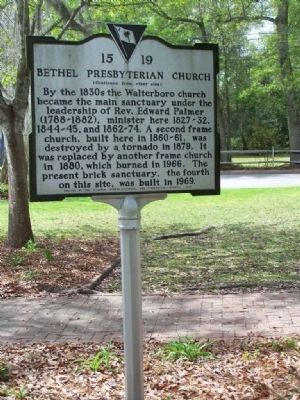
This church, originally located at Jacksonboro, was founded in 1728 by Rev. Archibald Stobo (d.1741), father of the Presbyterian church in S.C. The first building at Jacksonboro was replaced in 1746 by a "hansome sanctuary" . . . — — Map (db m7117) HM
On East McIver Rd. at Riverview Road, on the right when traveling west on East McIver Rd..
Early land records indicate that Samuel Bacot settled in the back country of S.C. about 1770. He served in the State Militia during the Revolution, was taken prisoner by the British in 1780, but with his companions made his escape, avoiding . . . — — Map (db m38093) HM
On Mechanicsville Hwy. at Lide Springs Road, on the right when traveling north on Mechanicsville Hwy..
One half mile east of this site Evan Pugh (1729-1802) is buried at Pugh Field near his homesite. He moved to this Pee Dee section in 1762 from Pennsylvania and served as a Minister for the Welsh Neck, Cashaway, and Mount Pleasant Churches of the . . . — — Map (db m38140) HM
On East Seven Pines Street, on the right when traveling west.
Born in Darlington County in 1859, William Dowling was a descendant of Robert Dowling, who had settled in S.C. in the Parish of St. David by 1773. William served as a member of the South Carolina House of Representatives, 1899-1900, and was . . . — — Map (db m38168) HM
Archdale Hall Plantation was established in 1681 by a royal grant of 300 acres to Richard Baker. The plantation, later expanded to more than 3000 acres, produced indigo and rice. The house which once stood here, built before 1750, was a fine example . . . — — Map (db m29914) HM
On Bacon's Bridge Road (South Carolina Route 165) south of Renken Road, on the right when traveling south.
(side 1)
An early bridge over the Ashley River near this site, built ca. 1696-1700, was first owned by John Stevens. Stevens sold this tract to Michael Bacon soon afterwards. Bacon’s Bridge became a public bridge in 1722. During the . . . — — Map (db m224503) HM
A small brick building once stood here housing the Dorchester Free School. The school offered free education to omly a few poor students. All others paid tuition. Opportunities for white children to learn outside the home or shop was limited. Black . . . — — Map (db m22659) HM
On Ashley River Road (State Highway 61), on the right when traveling north.
(Front text)
Middleton Place
These famous gardens were laid out about
1741 by Henry Middleton (1717-84), President
of Continental Congress. His son Arthur,
Signer of the Declaration Of Independence,
lived here as did his son Henry . . . — — Map (db m16281) HM
Newington Plantation was established on this site in the 1680s after Daniel Axtell recieved a royal grant of 300 acres. Axtell died shortly after arriving in the colony and his widow Rebecca built a house on the grant by the 1690s. In 1711 Lady . . . — — Map (db m23362) HM
Near Gahagan Road east of Berlin G Myers Parkway (South Carolina Route 165), on the right when traveling west.
On a primitive map of the land where the South Carolina Canal and Rail Road Company planned to build “New Summerville” in 1830, there appears a structure labeled “Old Dam.” This was the Axtell Dam, constructed about 1700, under the supervision of . . . — — Map (db m243217) HM
On Main Street (State Highway 23) at Buncombe Street (U.S. 25), in the median on Main Street.
From its earliest history, Edgefield developed a reputation for violence. The bloody fighting of the Cherokee War of 1760 was followed by years of lawlessness and retribution during the Regulator period. period. During the American Revolution . . . — — Map (db m12534) HM
On Jeter Street, on the right when traveling west.
Present-day Edgefield County was first settled in the 1750's, then a portion of a vast unsettled region of virgin forests, abundant wildlife and Indian tribes. From the time of the first settlements through the period of the American Revolution, . . . — — Map (db m12583) HM
1/2 mile west, on "Ceder Fields" plantation, is buried the family of Captain Arthur Simkins, soldier in the American Revolution and a founder of Edgefield. Born in Virginia on Dec. 10, 1742, he died Sept. 29, 1826. He was a county court judge, a . . . — — Map (db m12333) HM
On Jeter Street, on the right when traveling west.
The origin of the name "Edgefield" is shrouded in mystery. There are six principle theories as to how the name may have come to be applied to this county and town:
(1) Robert Mills, in his 1826 Statistics of South Carolina, said that the . . . — — Map (db m12541) HM
On West Martintown Road, on the left when traveling north.
Founded in 1762 by the Reverend Daniel Marshall, pioneer missionary and minister, this was the first church of the Baptist faith in the present Edgefield County, "Mother of Churches." — — Map (db m12860) HM
On Old Stage Road, on the right when traveling south.
Horns Creek Baptist Church
This church was constituted in 1768 by the Reverend Daniel Marshall, one of the founders of the Baptist faith in this part of South Carolina. Other early ministers of Horns Creek included Hezekiah Walker, Samuel . . . — — Map (db m12769) HM
On Old Stage Road, on the right when traveling south.
Religion
Founded in 1768 as a result of a religious revival sweeping the American colonies known as the "Great Awakening," Horn's Creek Baptist church was one of the first churches established in the South Carolina backcountry. The church . . . — — Map (db m12782) HM
On Landis Road, 0.8 miles south of South Carolina Highway 213, on the left when traveling south.
This two-story brick house was built by James Kincaid (1754-1801), Revolutionary War soldier, who came from Scotland in 1773 and acquired this land in 1775. It was completed according to his plans after his death by his son, William Kincaid . . . — — Map (db m14399) HM
On State Highway 901 at Heritage Road, on the right when traveling north on State Highway 901.
Here lie buried many of the Scotch Irish pioneers, who, in 1772, under the leadership of the Rev. William Martin, founded one of the first Covenanter churches in upper South Carolina. — — Map (db m14506) HM
On Monticello Road (State Highway 215) 0.3 miles north of Baltic Circle, on the left when traveling north.
1700s
Settlement
1730 – Governor Robert Johnson encourages settlement of the backcountry
1745 – The Lyles family, some of the earliest settlers in the area, purchased land along both sides of the Broad River near Beaver . . . — — Map (db m159720) HM
On Monticello Road (State Highway 215) 0.3 miles north of Baltic Circle, on the left when traveling north.
Early Settlement and the Lyles Family
In 1745, the Lyles family, some of the earliest settlers in the area, established their holdings on both sides of the Broad River, close to the mouth of Beaver Creek. Brothers, Ephraim and John Lyles, . . . — — Map (db m159721) HM
On Congress Street close to Washington Street, on the left when traveling north.
Fairfield County
A center of activity in the Regulator movement to bring law and order to the backcountry, this area in 1769 was made part of Camden District under the Circuit Court Act. In 1775 it formed part of the District between the . . . — — Map (db m47442) HM
On Odell Venters Landing east of Kingsbury Highway (South Carolina Route 41), on the right when traveling north.
The SC Revolutionary Rivers® trail highlights the American Revolution's Southern Campaign and in particular General Francis Marion, “the Swamp Fox.”
Designated a National Recreation Trail in 2014, the 66 miles of river offer paddlers a . . . — — Map (db m223551) HM
On Johnsonville Highway (State Highway 341), on the left when traveling west.
This area is part of several royal landgrants to Moses Brown in 1768-69 which developed into a family community known as Browntown. Family holdings here eventually comprised over 8,000 acres. Many indications of pioneering ingenuity and . . . — — Map (db m222564) HM
On County Route 57 at Bluff Road, on the right when traveling north on County Route 57.
[Front] Located about 1/2 mile east, this bluff, part of a Royal landgrant to Edward Crofts in 1740, was named for the DeWitt family, who settled nearby prior to 1767. This area of Prince Frederick Parish was known as Queensborough . . . — — Map (db m37313) HM
On North Williston Road (State Highway 327) 0.2 miles north of E. Pocket Road, on the right when traveling north.
Roseville Plantation was established by a royal grant before the American Revolution and a house was built here ca. 1771 for the Dewitt family. Richard Brockinton (d. ca. 1843), planter and state representative, purchased Roseville in 1821. Most of . . . — — Map (db m37327) HM
On North Williston Road (State Highway 327) 0.6 miles East Pocket Road, on the right when traveling north.
Roseville Plantation Slave And Freedman's Cemetery This was originally the slave cemetery for Roseville Plantation. Roseville, established about 1771 by the Dewitt family, was later owned by the Brockinton, Bacot, and Clarke families from the . . . — — Map (db m37337) HM
On Pump House Landing Road, 1.4 miles west of Indian Hut Road, on the right when traveling north. Reported missing.
(Front)
This is the site of a "Dissenter" meeting house, built ca. 1726 by one of the first Baptist congregations in S.C. outside of Charleston. It was founded by Rev. Elisha Screven (d. 1754). The elder Screven had founded a Baptist . . . — — Map (db m243938) HM
On Beneventum Road at Kingsbury Place, on the right when traveling east on Beneventum Road.
(front)
The main house at Beneventum dates to ca.1755. It was likely commissioned by William Fyffe, a surgeon and Scottish emigrant who acquired 500 acres from James Coachman in 1754. Fyffe's plantation was known as The Grove. . . . — — Map (db m202215) HM
On Broad Street east of Church Street / Ocean Highway (U.S. 17), on the left when traveling west.
This cemetery, established ca. 1772, is the second oldest Jewish cemetery in the state and serves a community which has been significant here since well before the American Revolution. Abraham Cohen and Mordecai Myers, who opened stores in the town . . . — — Map (db m4857) HM
Elisha Screven. Elisha Screven, founder of Georgetown, was a younger son of William, who owned and lived his final years on these Wynyah lands. To promote settlement here, Elisha planned a town, to be called Georgetown, which reserved lots for . . . — — Map (db m7604) HM
Near Front Street at Broad Street, on the right when traveling south.
(front)
Ships and boats have loaded and unloaded cargo at the Sampit River near Front Street since the founding of Georgetown, ca. 1729. In 1732 Georgetown became an official port of entry, shipping naval stores rice, indigo, pork and . . . — — Map (db m202220) HM
On Highmarket Street (U.S. 521) west of Screven Street, on the left when traveling east.
Georgetown, the third oldest town in the state, was laid out in 1729 by Elisha Screven on land granted to John and Edward Perrie, Sept. 15, 1705, and deeded by him, Jan. 18, 1734, to George Pawley, William Swinton, and Daniel La Roche, Trustees. It . . . — — Map (db m7422) HM
Near King Street at Front Street, on the left when traveling south.
Georgetown’s Industrious Past
Port of Georgetown
Indigo was first introduced to the area around the 1740's and served as Georgetown's first principal cash crop. Taking advantage of British bounties for indigo, highly prized as a clothing dye in . . . — — Map (db m100768) HM
Thomas Lynch, Jr., signer of the Declaration
Of Independence, was born here Aug. 5, 1749.
He was elected from St. James Parish, Santee,
to 1st Provincial Congress, Dec. 19, 1774; to
2nd Provincial Congress, Aug. 7-8, 1775; to
the Continental . . . — — Map (db m16299) HM
On Duke Street at King Street, on the left when traveling east on Duke Street.
After purchasing this land January 1, 1866, Georgetown Colored Academy built a school here. By 1908 the old building had been torn down and a new school built, its name changed to Howard. The elementary department moved into a new structure on . . . — — Map (db m7864) HM
On Front Street at St. James Street, on the right when traveling east on Front Street.
This house, one of Georgetown’s earliest, was built ca. 1737 by John and Mary Perry Cleland. Mrs. Cleland inherited the property from her father John Perry, who had been granted a large tract in 1705 including the site of present-day Georgetown. . . . — — Map (db m7863) HM
On Front Street near King Street, on the left when traveling west.
This house, probably built between 1750 an 1800, was for many years the home of Harold Kaminski (1886–1951), Georgetown County commissioner, mayor 1930–35, and U.S. Navy officer, and his wife Julia Bossard Pyatt (d. 1972). The house was . . . — — Map (db m98297) HM
On Highmarket Street (U.S. 521) east of Broad Street, on the left when traveling east.
Parish founded 1721. Present church erected about 1750. Aided by the Society for the Propagation of the Gospel in Foreign Parts, London. Occupied by British forces during the Revolution. — — Map (db m7421) HM
On Highmarket Street (U.S. 521) east of Broad Street, on the left when traveling east.
Prince George’s Parish, Winyah, was created March 10, 1721, and the parish church erected on Black River, 1726, at the present Brown’s Ferry. After Prince Frederick’s Parish was formed from Prince George’s, April 9, 1734, the parish church was . . . — — Map (db m82442) HM
On Front Street north of King Street, on the right when traveling north.
The Robert Steward House was built between 1740 and 1770 by Robert Stewart (d.1776), planter and militia captain; it was acquired in 1787 by Daniel Tucker (d. 1797), prominent Georgetown merchant. When President George Washington arrived in . . . — — Map (db m4856) HM
Here are buried William Screven (1624–1713) and other members of his family. A native of England, he migrated to Kittery, Me., and was persecuted by New England authorities for non-conformity. He and other members of the Kittery Church came to . . . — — Map (db m7612) HM
Founded in 1729, Georgetown is the third oldest city in South Carolina and was named for George, Prince of Wales, who later became King George II. Settled by migrating families from Charleston, the colonial residents made their livelihood as . . . — — Map (db m9971) HM
Near Orange Street at Front Street, on the left when traveling south.
Port of Georgetown
South Carolina's Third Oldest City
It is believed that the Spanish first settled an outpost on Winyah Bay in 1526. Allegedly, this settlement only lasted six months and no remains have ever been found. Georgetown was formally . . . — — Map (db m100767) HM
On S. Fraser Street (U.S. 17) at Crow Hill Drive, on the right when traveling south on S. Fraser Street.
The Oaks Plantation was established
on the Santee River in 1705 by a grant
from the Lords Proprietors to John
Sauseau, a French Huguenot settler.
It passed through several owners in
the prominent Buchanan and Withers
families before 1793, when . . . — — Map (db m16383) HM
Near Front Street at Screven Street, on the left when traveling north.
The rice culture in Georgetown County is one of the most colorful chapters in American History. Through maps, dioramas, artifacts, "The Garden of Gold" video produced by the museum, and other exhibits, the Rice Museum tells the story of the rice . . . — — Map (db m68021) HM
A pioneer Baptist preacher of Somerton, England. Immigrated to Kittery, Maine. Forced to leave that state for preaching the gospel. Came south with a group of Baptists. Organized first Baptist church in the South, in 1683, at Charleston and served . . . — — Map (db m102503) HM
On Myrtle Avenue (State Highway S-20-10) near South Causeway Road, on the left when traveling north.
Pawley’s Island
This island, located about ½ mile east, was used by plantation householders who lived on the seashore from May to November to escape malaria, or “summer fever.” A number of houses built about 1850, and the . . . — — Map (db m39647) HM
On Plantersville Road, on the right when traveling north.
This plantation, with its origins in several grants to John Allson in 1732, 1734, and later, was in the hands of his grandson Benjamin, Jr., of Brookgreen, by 1806. The property passed first to Benjamin's widow Charlotte and then after her death in . . . — — Map (db m27546) HM
On Plantersville Road, on the right when traveling north.
(Front) The first church on this site, known as Prince Frederick's Chapel, Pee Dee, was built in 1848 on a site donated by the Rev. Hugh Fraser in 1834. Most of its parishioners were rice planters along the Pee Dee River. These ruins are of . . . — — Map (db m27717) HM
On Dunklin Bridge Road, on the right when traveling west.
[Front]:
Approximately 2 miles s.e. is the corner of the Old Indian Boundary Line. Nearby is also the original site 1785 of the following:
Lebanon Church, the Rev. Mark Moore's School, the Grove Settlement.
The church . . . — — Map (db m16323) HM
On Rutherford Street (State Highway 25) at Poinsett Highway and Shaw Street, on the right when traveling north on Rutherford Street.
"The Poplars"
This was approximately the center of the many acred estate and "seat of hospitality" of Elias Earle, pioneer Greenville settler who began acquiring property here as early as 1787. His home, "The Poplars," stood at the N.E. corner . . . — — Map (db m9084) HM
On South Main Street (State Highway 124), on the left when traveling south.
Near Reedy River Falls, stood the home, trading station, and grist mill of Col. Richard Pearis, first white settler of this section. He was a noted Indian trader and prominent Tory of the Revolution. — — Map (db m10428) HM
On East Camperdown Way (State Highway 124), on the right.
Near this sign, before the adoption of the Declaration of Independence, Richard Pearis, best known of all Pre-Revolutionary settlers in the surrounding Cherokee Indian nation, established his home with a grist mill and trading post. Around this . . . — — Map (db m8208) HM
Austin Plantation: Settled before the Rev. War by Nathaniel Austin (c. 1720 - c. 1800) and his wife, Agnes Dickinson. Ten sons: Nathaniel, Jr., Walter, Thomas, John, Francis, Dickinson, William, Thompson, Samuel & Robert. One daughter: Mary. . . . — — Map (db m15996) HM
On South Main Street at Broad Street, on the left when traveling south on South Main Street.
This flag, often referred to as the Guilford Courthouse Flag, is an example of the diversity of American flags during the Revolutionary War period. It has the unique design elements of an elongated canton with white background and 13 blue, . . . — — Map (db m10863) HM
An adventurous hero or an opportunistic traitor, Richard Pearis led a life touched by many of colonial America's defining themes. Leaving Virginia, he settled by the Reedy River in 1768 and is credited with being the first to harness local . . . — — Map (db m20205) HM
Greenville County was Indian Territory before the Revolution. European settlers were forbidden to live here until 1777, when Cherokee Indians were forced to cede this land to the new state. Most of modern day Greenville was hunting land used by . . . — — Map (db m8210) HM
On East Broad Street at Main Street on East Broad Street.
Our South Carolina state flag represents one of the oldest flag designs still in use. Its design elements go back to 1765 when three white crescents were used on a blue flag by protesters against the Stamp Act. Ten years later, a flag with a single . . . — — Map (db m10856) HM
On South Highway 14 (State Highway 14), on the left when traveling north.
[Front]:
In 1766-67 S.C. & N.C. negotiated with the Cherokee to establish a boundary between Indian land to the west and new settlement to the east. This north-south line ran past this point to N.C. and on to Va. In S.C. it ran north . . . — — Map (db m8446) HM
On Gibbs Shoals Road (County Road 164) 0.1 miles north of East Suber Road (County Road 540), on the right when traveling south.
[Marker Front]:
Early White Settlement
By 1768 Indian traders and land speculators Richard Pearis (d. 1794) and Jacob Hite of Virginia acquired large tracts from the Cherokees in present-day Greenville County. Though royal . . . — — Map (db m24254) HM
On Wade Hampton Blvd. (U.S. 29) near Baileyview Street, on the right when traveling east.
This marks the eastern boundary (the present Greenville-Spartanburg county line) between the Cherokee Nation and the province of South Carolina from the end of the Cherokee War (1759-61) until 1777. In that year, the Treaty of DeWitt's Corner . . . — — Map (db m11264) HM
Two miles west is Power Spring, traditional site of the town laid out for the Londonborough settlers in 1765. Abandoned by their promoter in London, some three hundred German settlers were brought to South Carolina, given aid and bounty, and . . . — — Map (db m11378) HM
On Christian Road (Old State Highway 72) at Laurens Highway (State Highway 221), on the right when traveling south on Christian Road.
This young English Jew settled near Coronaca in 1774, representing Ninety Six District in the provincial congresses of 1775-1776, and died in defense of his adopted home on Aug. 1, 1776. He was the first South Carolinian of his faith to hold an . . . — — Map (db m11117) HM
On Cokesbury Road (State Highway 254), on the right when traveling south.
Park's: America's Most Trusted Gardening Resource
Building a Family Tradition Since 1868
It all started in 1867 when 15 year-old George Watt Park, a very enterprising lad, passed around to friends and neighbors a list of seeds he had . . . — — Map (db m11628) HM
The trench that ran here, from the fort to the stockaded town, was not actually covered, but was used for cover. It was the route for official couriers, Loyalist relief troops, and slaves who risked Patriot fire to bring water from . . . — — Map (db m125703) HM
Once dense forest, this area was gradually cleared by people. Fire, storms, and the introduction of non-native plants and animal species also contributed to changing the landscape. If you lived here in the 1700s, you would have seen these woods . . . — — Map (db m32790) HM
The Gouedy trail is a 1.5-mile nature path that takes you through the woods and into a lesser known for historically significant part of the park. This route passes the presumed location of Robert Gouedy's trading post, established in 1751, and . . . — — Map (db m33537) HM
The earliest roads in Ninety Six were Indian trails, used for travel by foot and horse and for hunting. White settlers followed these trails to explore the countryside, trade, and eventually, to settle. As the stream of settlers into the region . . . — — Map (db m11159) HM
The Ninety Six jail stood on this site and the courthouse was about 100 yards from it, near the Charleston Road. After the Revolutionary War, the jail fell into disrepair and its bricks were reused for other purposes. But from 1772, when it was . . . — — Map (db m125704) HM
Andrew Logan built this house in the late 1700s. The house was the first home built in the nearby town of Greenwood, SC and was actually found hidden in the core of an old house. It was moved here in 1968 where it was put under the protection of . . . — — Map (db m30719) HM
Built by Andrew Logan in the late 1700s, this well preserved example of a log house of that time was discovered in nearby Greenwood. The historic stricture has been hidden under siding and obscured by alterations from a much later period. . . . — — Map (db m30731) HM
This stone honors James Birmingham, the first South Carolinian to lose his life for freedom during the Revolutionary War. Birmingham, a member of the Long Cane Militia, received his fatal wound from a Loyalist musket ball. He fought under the . . . — — Map (db m11312) HM
The convergence of roads at Ninety Six ensured its success as a hub of commerce, center for law and order, and haven for settlers in colonial times. In 1775 the village had a dozen dwellings, a jail, and, most importantly, a courthouse, making it . . . — — Map (db m11304) HM
On South Cambridge Road (State Highway 248) at County Route 225, on the right when traveling south on South Cambridge Road.
Ninety Six National Historic Site is a unit of the National Park Service, which preserves lands of national significance. This park features the site of the old town of Ninety Six, an important seat of power in the backcountry of South Carolina . . . — — Map (db m30565) HM
Near South Cambridge Street (State Highway 248) 0.1 miles north of Louden Road, on the left when traveling south.
Ninety Six National Historic Site is a unit of the National Park Service, which preserves lands of national significance. This park features the site of the old town of Ninety Six, an important seat of power in the backcountry of South Carolina . . . — — Map (db m125710) HM
A plentiful water source was essential for the colonial residents of Ninety Six and for both Patriot and Loyalist troops garrisoned here during the Revolutionary War. The water surely flowed more freely in colonial times. During the sweltering . . . — — Map (db m125706) HM
Once a parallel was dug, troops could move artillery forward and place cannon in position to batter the enemy garrison. Greene's six-pounders (guns firing six pound cannon balls) were placed here on platforms that sat on earthen fortifications . . . — — Map (db m125698) HM
On South Cambridge Street (State Highway 248) at County Route 225, on the right when traveling south on South Cambridge Street.
After the Revolution, the American government confiscated land that belonged to prominent Loyalists. You are standing on such a tract, and it became the site of a new town of Ninety Six in 1783. The old town, near the Star Fort -- never rebounded . . . — — Map (db m125707) HM
"We shall be in the ditch of the enemies works by tomorrow night or early morning; and the powder is wanting to blow up the works. I beg you will send the powder the moment this reaches you."
General Nathanael Greene to General Andrew . . . — — Map (db m125702) HM
In a single night -- June 13 -- a 30-foot tower made of interlocking logs was erected under Kosciuszko's supervision. From the wooden platform marksmen could aim down into the fort. The Loyalists responded to this threat by making the walls . . . — — Map (db m125701) HM
Near South Cambridge Street (State Highway 248) 1.2 miles south of Johnston Road (State Highway S-24-72), on the left when traveling south.
In November 1775 — just months after American and British troops traded musket fire at Lexington and Concord, Massachusetts — the first southern land battle of the Revolutionary War was fought here in Ninety Six. Later, in 1781, the . . . — — Map (db m30623) HM
Water was critical to the survival of the men confined to the Star Fort, but the town's only water source, Spring Branch, lay well beyond its walls and within range of Patriot fire. Cruger hoped to remedy this dire situation by digging a well . . . — — Map (db m11293) HM
Near State Highway 248, 0.1 miles north of Louden Road, on the left when traveling south.
Follow the paved path to explore a colonial roadbed, Revolutionary War siegeworks and the original Star Fort, the site of the early town of Ninety Six, the reconstructed Stockade Fort of 1781, and the Logan Log House. The one-mile walk starts out in . . . — — Map (db m125696) HM
The quiet field before you was the site of the once-thriving 1700s town of Ninety Six. In 1781 it had about a dozen homes, a courthouse, and a jail. When Lieutenant Colonel Cruger arrived in 1780, he fortified it against attack. One visitor . . . — — Map (db m33468) HM
Near South Cambridge Street (State Highway 248) 1.2 miles south of Johnston Road (State Highway S-24-72), on the left when traveling south.
The origin of Ninety Six's unusual numeric name remains a mystery. There are many theories. One plausible explanation is that English traders who passed through here in the 1700s estimated this location to be 96 miles from the Cherokee village of . . . — — Map (db m30703) HM
On Main Street West near Twigg Street (South Carolina Highway 10).
Three miles west is the site of an attack by Cherokee Indians upon settlers of Long Canes in the Cherokee war of 1759-1761. There on February 1, 1760, about 150 settlers, refugeeing to Augusta, were overtaken by 100 Cherokee warriors. Twenty-three . . . — — Map (db m9433) HM
On Main Street (Business U.S. 701) south of 3rd Avenue, on the right when traveling south. Reported missing.
Kingston-Conway
By 1733, Kingston Township
had been “marked out”
in this area, and by 1737
the town of Kingston was
in existence. Since many
landowners were non-residents, the township
did not flourish. In 1801,
the town was . . . — — Map (db m226632) HM
Peter Horry. A planter of French Huguenot descent, Peter Horry (O-ree) was born in SC ca. 1747. A lieutenant colonel in the Revolution and later brigadier general in the SC Militia, he represented Prince George Winyah in the SC House and . . . — — Map (db m11262) HM
On Highway 17 northbound lanes (U.S. 17) north of South Carolina Highway 90, on the right. Reported missing.
On Jan. 1, 1740, George Whitefield, a fiery disciple of Methodists John and Charles Wesley preached at a tavern near here. Observing patrons dancing, Whitefield exhorted them against that vice. Soon the dancers stopped and allowed Whitefield to . . . — — Map (db m16373) HM
Near North Ocean Boulevard at 9th Ave N., on the right when traveling north.
By the mid 1700’s a 1,300 mile continuous road linked all thirteen colonies. Called the “King’s Highway” the thoroughfare stretched from Boston, Massachusetts to Charles Town, South Carolina. It took at least two months for wagons averaging about . . . — — Map (db m100720) HM
(Front Side): Coosawhatchie, dating to the 1740s, was named for the Coosaw Tribe. At first it was little more than a store and inn built on the King's Highway by Henry De Saussure, a Huguenot settler from Purrysburg. By the 1760s, it was a . . . — — Map (db m4293) HM
Established on Edisto Island about
1686 by Scotch dissenters, this
is the second oldest Baptist
organization in the South. For
many years a branch of First
Baptist Church in Charleston, Euhaw
declared itself a separate church
in 1745 . . . — — Map (db m8674) HM
On T. Heyward Tomb Driveway (Old State Highway 462), on the right when traveling east.
Settled ca. 1740 by Daniel Heyward
who built Tidal Mill, Textile Factory
and export-import business on these
grounds before his death in 1777.
Original 500 acres King's Grant
grew to 16,000 acres, all destroyed
by fire ca. 1865 — — Map (db m6414) HM
On State Highway 462, 0.1 miles south of State Highway 27-336, on the left when traveling south.
Member of South Carolina Provincial Congress and Council of Safety and of Continental Congress. Signer of Declaration of Independence and Articles of Confederation and captain of militia at Battle of Port Royal and Siege of Charleston. Prisoner of . . . — — Map (db m6415) HM
On Purrysburg Rd (State Highway S-27-34) near Honey Hill Road (State Highway S27-203), on the right when traveling south.
(Front text ):
In 1730, the British Crown instructed S.C.
Governor Robert Johnson to lay out eleven
townships to populate and protect the
interior of the province. Purrysburg
Township, laid out in 1731, stimulated the
settlement of . . . — — Map (db m6353) HM
On Dekalb Street (U.S. 1), on the right when traveling west.
This area, first held by Wateree and Catawba Indians, was laid out as Fredericksburg Township in 1733. Here on the Catawba Path the trading town of Pine Tree Hill was settled. In 1769 courts were set up and the town named Camden in honor of Lord . . . — — Map (db m27622) HM
403 entries matched your criteria. Entries 201 through 300 are listed above. ⊲ Previous 100 — Next 100 ⊳