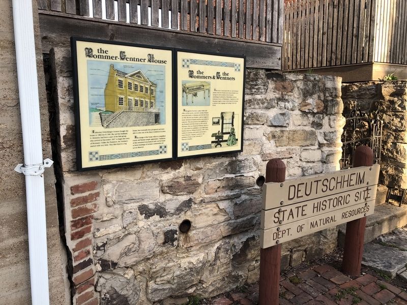
This house is associated with two early Hermann families. Both the Pommer and Gentner families were among the initial members of the Deutsche Ansiedlungs-Gesellschaft zu Philadelphia (German Settlement Society of Philadelphia). Organized in 1836, . . . — — Map (db m169329) HM
The "railroad track" pattern was chosen to honor this railroad hotel built in 1910. It now houses the Gasconade County Historical Society Museum. — — Map (db m139786) HM
The Heartland Quilt Guild Carries on the stitching tradition of Owensville's Founding Fathers who sewed in the shoe factory to support their families and the founding mothers who sewed to clothe their families and cover their beds with warmth. — — Map (db m139780) HM
An archaeological study is a lot like a detective story. In 1966 an archeological investigation uncovered many bits of evidence from the area in front of you - the remnants of John and Martha Gibson's home. Bone handled dinner service, pewter . . . — — Map (db m35146) HM
In the summer of 1861, the small mill of John Gibson stood here. Although Confederate soldiers camped nearby and Union soldiers forded the stream here, the mill escaped the heavy fighting that raged just downstream. In 1966 archeologists discovered . . . — — Map (db m35147) HM
The surrounding young forest can tell us much. Agriculture has long dominated the landscape. Nearby, John Gibson's horsedrawn plow broke ground for an oat field. Later, tractors would shape and alter the countryside. In the course of this evolution . . . — — Map (db m35144) HM
Many before you... have traveled the path to the mill. Although our reasons have changed, the way to the mill has always been popular. In the days before supermarkets and, pre-packaged "ready-made" foods, families depended on small mills such as . . . — — Map (db m35143) HM
Built in 1883 and operated until 1969. It has significantly contributed to the history of Fair Grove and Greene County.
Greene County Historic Sites Board
April, 1987 — — Map (db m64399) HM
Born in Fairview, MO in 1919 to
James O. and Hortense (Bass) Hammons
Attended Fairview Schools and
Southwest Missouri Teachers College
Married Juanita K. Baxter in 1949
Entered into hotel development in 1958 by
purchasing 10 Holiday . . . — — Map (db m72091) HM
Southwest Missouri State University used a college housing loan from the United States Department of Education to purchase Kentwood Hall, formerly the Kentwood Arms Hotel, from the Kentwood Arms Hotel Company. The SMSU Board of Regents authorized . . . — — Map (db m173595) HM
West of this marker 480 feet a construction train of South Pacific Railroad ~~ now St. Louis-San Francisco Railway (Frisco) ~~ pulled into new town of North Springfield at 3 P.M., April 21, 1870. First passenger train, with state and railroad . . . — — Map (db m170811) HM
Site of Gen. Nicholas Smith's tavern on Boonville Road, earliest outlet of Springfield, also station of Butterfield Stage Route carrying first overland mail from St. Louis to Pacific Coast. Government subsidy $600,000 yearly. First mail left St. . . . — — Map (db m43089) HM
Near this spot was located the first post office in Springfield, in a one story, hewed log cabin, occupied by John Polk Campbell, who was appointed postmaster, Jan. 3, 1834. Mail was brought on horseback twice a month from Harrison's Store, on . . . — — Map (db m43120) HM
Site of first store in southwest Greene County, a little log cabin, supplied with goods from Boonville, Missouri, 1831, and conducted by Junius T. Campbell, brother of John P. Campbell, founder of Springfield. Marker erected 1921 by Reps Dry Goods . . . — — Map (db m43088) HM
On this site stood the Colonial Hotel, hailed as "one of the most modern hotels in the world" when it opened in 1907. For more than a half-century, the Colonial Hotel served as an anchor for downtown Springfield and hosted nearly every type of . . . — — Map (db m170900) HM
To your left, atop what was once a Springfield Grocer Company building, is the sole surviving Yellow Bonnet Girl sign. In the mid-1900's, this familiar, much-loved label was the symbol for products of the Springfield Grocer Company. The "Girl" . . . — — Map (db m170814) HM
One of the few remaining "old style" designs for this chain of drive-in restaurants, opened in 1962. It still features curb service, steak burgers and hand-dipped milkshakes. — — Map (db m170629) HM
Red's Giant Hamburg was a business on the west end of Route 66 in Springfield, Missouri, which is believed to have been the world's first drive-through restaurant.
The business's name was supposed to be "Red's Giant Hamburger," but owner . . . — — Map (db m170766) HM
Built by George S. Day around 1875, the Day House is considered to be the oldest brick residence in Greene County. The Day House is constructed - both the interior and exterior -- of solid brick walls. There is no better example of post-Civil War, . . . — — Map (db m170832) HM
[Side A]
Henry County, in the prairie region of west central Missouri, was organized 1834, and named for Va. statesman William C. Rives. It was renamed for Patrick Henry in 1841, after Rives changed from Democrat to Whig. Through the . . . — — Map (db m69513) HM
[side 1] One of 6 counties formed in the Indian Platte Purchase Territory, annexed to the State 1837, Holt County was organized in 1841 and named for State legislator David Rice Holt. The county's 456 square miles, bounded . . . — — Map (db m179434) HM
New Franklin, known as the city where four trails meet, owes its place in history to the Lewis & Clark Expedition of 1803-1806; the blazing of the Boonslick Trail pioneered by Daniel Boone from Kentucky to the original historic rivertown of . . . — — Map (db m46460) HM
Franklin, 1816
The original town of Franklin, founded in 1816, was located on the north bank of the Missouri River and was the seat of Howard County. It was about two miles southwest of present day New Franklin. The town was named for . . . — — Map (db m46464) HM
As the first railroad to enter Texas from the North in 1872, the Missouri-Kansas-Texas Railroad Co. was an influential factor in the development of the Great Southwest. Soon after its construction began, the railroad became commonly known as the . . . — — Map (db m46517) HM
Father of the Santa Fe Trail
William Becknell led a small group out of Franklin in 1821 on the first trip along what would be known as the Santa Fe Trail. If his trip across the Great Plains was successful, the group would make money trading . . . — — Map (db m46932) HM
[side 1] Judicial seat of Howell County and one of Missouri's livestock marketing centers, West Plains was formed in 1850 when a post office was opened in the home of Josephus Howell. Named for its location on the open plains . . . — — Map (db m179790) HM
Buford Mountain
William Buford, namesake of Buford Mountain, was buried in 1842 at its base, forever to be with the mountain he loved. Its southernmost of five knobs reaches to 1,740 feet above sea level.
“Just bury me by . . . — — Map (db m99161) HM
Settlers to what we now call Iron County arrived in the first few decades of the 19th century. Little did they know what would unfold just a few more decades later when the Civil War erupted in Missouri.
One of those first settlers was Ephraim . . . — — Map (db m99167) HM
The iron furnace is the most visible remains of what was once a thriving iron mining industry in the Arcadia Valley. The first iron furnace was constructed in 1848, but was destroyed by the rebel army after the Battle of Pilot Knob. It was rebuilt a . . . — — Map (db m99208) HM
The three towns of Arcadia, Ironton, and Pilot Knob are located in the Arcadia Valley. The valley’s iron mining industry helped spur population growth and led the St. Louis & Iron Mt. Railroad to extend its tracks to Pilot Knob in 1858. The . . . — — Map (db m99213) HM
Hiram Young came to Missouri as an enslaved African American. He earned his freedom step by step. First he purchased his wife Matilda's freedom in the early 1840s. For children to be free, they had to be born to a free mother. The Youngs welcomed . . . — — Map (db m208243) HM
Being at leisure one day, I rode over to Independence [from Westport, in May 1846]. The town was crowded. A multitude of shops had sprang up to furnish the emigrants and Santa Fe traders with necessaries for the journey; and there was an . . . — — Map (db m208146) HM
The home of Dr. and Mrs. Bryant was built ca. 1867, and expanded to its present Queen Anne-Eastlake design by ca. 1890. Dr. Bryant was a prominent physician and successful businessman. Harriet Smart was the daughter of Judge Thomas A. Smart, a . . . — — Map (db m144703) HM
Clinton's Drugstore was the site of young Harry Truman's first job in about 1898. Jim Clinton paid Truman three dollars per week. — — Map (db m34787) HM
Side A:
Independence, famed "City of the Trails," was for two decades the starting point of the great western trade and travel routes to Santa Fe, Oregon, and California. Settled mainly by Southerners on land ceded the U.S. by the Osage . . . — — Map (db m44323) HM
Martin Kritser, a grocer, bought this lot in 1847 and probably had the house built soon after. Patrick McCarty, one time saloon keeper on this square, bought it in 1849. This modest house is typical of the majority of houses built during the city's . . . — — Map (db m34843) HM
In 1856 this Greek Revival and Italianate style house was completed by William McCoy, a merchant and banker, on property once owned by Samuel C. Owens, a merchant and Santa Fe trader. McCoy served as the first Mayor of Independence, MO., in 1849. — — Map (db m144541) HM
Erected in 1887 by Aaron Flint Sawyer, a partner in the Chrisman - Sawyer Banking Company, this Queen Anne style residence is the design of T.B. Smith, a talented Independence, Mo., architect and builder. — — Map (db m140794) HM
Mr. and Mrs. Charles Lindsay Minor acquired this home ca. 1900. Mrs. Minor was the former Nancy M. McCoy, daughter of William McCoy, an early Independence business man and the first Mayor at the time of the city’s incorporation in 1849. Their . . . — — Map (db m144551) HM
People on steamboats loaded with goods traveled upstream on the Missouri River "highway" to Independence, where the overland journey on the Santa Fe, Oregon, and California trails began. Between March and November, steamboats passed by or stopped . . . — — Map (db m208241) HM
Built about 1867 by George Porterfield Gates, a mill owner. President Harry S. Truman and his wife, Bess Wallace Truman, granddaughter of Gates, made this their home from the time of their marriage in 1919. The "Summer White House" from 1945 to . . . — — Map (db m34731) HM
"It was in the Clinton's Drugstore that Harry S. Truman obtained his first job at three dollars a week. He opened the store every morning at six thirty, mopped the floor, cleaned away the trash, polished the jugs and bottles, worked at the . . . — — Map (db m34789) HM
Originally platted as part of the City of Westport and intended as a planned, residential area, Janssen Place was conceived and developed by Arthur E. Stilwell, an urban planner and railroad magnate who founded Kansas City Southern and other . . . — — Map (db m194979) HM
2000 Baltimore Avenue
has been placed on the
National Register
of Historic Places
by the United States
Department of the Interior
1913 — — Map (db m199581) HM
In 1803, President Thomas Jefferson doubled the size of the United States with the purchase of 530 million acres of land from the French government. The Louisiana Purchase captured the imagination of our nation with promises of adventure and . . . — — Map (db m199280) HM
At the confluence of the Missouri and Kansas (Kaw) rivers, on the great bend of the Missouri, longest of the U.S. rivers, this famous city of the vast Missouri Valley was first incorporated, 1850, as the Town of Kansas. The first white man known to . . . — — Map (db m198773) HM
Opening as the Kansas Stockyards Company on June 1, 1871, it soon was renamed and reorganized as a bi-state Kansas City Stock Yards Company, growing to 13 acres by 1878. Built by enterprising railroad officials such as C.V. Morris and stock traders, . . . — — Map (db m199289) HM
The roots of the American Royal stem from the National Hereford Show in the fall of 1899, held in a tent in the Kansas City Stockyards. The American Royal was the first nationwide show for the exposition and sale of purebred cattle, having an . . . — — Map (db m199287) HM
Built in 1887 for the Chicago, Milwaukee and St. Paul Railroad, the expansive brick building, known in Kansas City as the "Freight House," was originally used as a freight terminal for the historic rail line. The combination freight and office . . . — — Map (db m199579) HM
In October 1995, the Freight House was acquired by Kansas City Freight House LLC, for an adaptive reuse project. Construction of the up-scale urban restaurant, Lidia's, began in the spring of 1998 and was completed by the fall. As part of the . . . — — Map (db m199580) HM
Following the flood of 1903, Kansas City's original Union Depot, located in Kansas City's west bottoms, was rebuilt on this site in 1914 as Union Station and heralded as one of the most beautiful train stations, and the third largest passenger rail . . . — — Map (db m198768) HM
This 1880s iconic clock was originally constructed by the E. Howard Clock Company. By the mid-1880s it sat at the corner of 10th and Main Streets. In 1918, it was moved to 11th and Grand Avenue. Then in 1936, it was moved to Union Station where, . . . — — Map (db m198747) HM
Known as:
• Muehlebach Field (1923-1937) • Ruppert Stadium (1937-1943)
• Blues Stadium (1943-1954) • Municipal Stadium (1955-1976)
(front side:)
You are standing on the former site of Municipal Stadium, originally named . . . — — Map (db m198918) HM
The Savoy Hotel was constructed between 1890 and 1906 during a building boom which created some of the most architecturally significant buildings in the central business district. The first major hotel enroute from the old Union depot, it served as . . . — — Map (db m19831) HM
12 East Armour Boulevard was the original headquarters of Interstate Bakeries Corporation (IBC), now Hostess Brands, Inc. Hostess Brands owns Hostess and Dolly Madison snack cakes and Wonder, Nature's Pride and Butternut breads. — — Map (db m198770) HM
In 1910, the Southland Hotel, located at 3517 Main Street, advertised itself as one of the "most complete and up to date suburban hotels in the west." — — Map (db m198771) HM
J. C. Nichols was one of those rare individuals, a dreamer with a capacity for making his dreams come true. He dreamed more over in terms of great practical benefit to his city, few men can have so variously and profoundly influenced the . . . — — Map (db m88238) HM
Amache Ochinee Prowers (ca. 1846-1905) was born near Bent's Fort, the daughter of a Cheyenne chief named Ochinee. In 1861, as a teenage girl, she married John Prowers, a trader with Bent, St. Vrain & Co. For a time, Amache and her husband lived in . . . — — Map (db m199381) HM
William Rockhill Nelson, visionary force in the development of Kansas City, was born March 7, 1841, in Fort Wayne, Indiana.
In September 1880 he arrived in Kansas City with business partner, Samuel Morss, and they launched the newspaper that . . . — — Map (db m144140) HM
By late 1890's, Kansas City began its third major boom and industry expanded into residential neighborhoods. To escape the encroaching commercial activity, parks and boulevards were built east of downtown, near the old Scarritt homestead. This new . . . — — Map (db m63698) HM
Majors, “the great freighter,” was born in Kentucky. He entered the freighting business in 1848. He became managing partner of Russell, Majors and Waddell in 1854 with offices in Westport. The wagon trains moved enormous tonnage on the . . . — — Map (db m87330) HM
Jim Bridger was one of the most famous of the mountain men. He was an Indian fighter fur trapper and trader, guide to the Far West, U.S. Army Scout and explorer. He discovered the South Pass through the Rockies in 1827, the Great Salt Lake in 1834, . . . — — Map (db m87334) HM
Historians have called McCoy “the father of Kansas City”. In 1833 he platted a town around the trading post he built on lot No. 1 (northeast corner of Westport Road and Pennsylvania). Calling it “West Port,” Missouri, he . . . — — Map (db m87333) HM
(Main Marker)
Originally used as an outfitting store for wagon trains, this building was completed in 1850 by Indian traders George and William Ewing and was sold in 1854 to Albert Gallatin Boone for $7,000. Boone operated the store . . . — — Map (db m20921) HM
This map gives a geographic picture of the three trails during the opening of the west from 1845 to 1860. The years note when an area became a territory or was admitted as a state.
The Santa Fe Trail, 770 miles, blazed by William Bicknell in . . . — — Map (db m87320) HM
Originally known as Ottawa, 12th Street spanned from the West Bottoms, nestled in the confluence of the Kansas and Missouri rivers, to the eastern suburbs, dotted by small bungalows. At first a colorless retail strip, 12th Street blossomed into an . . . — — Map (db m200146) HM
When Kansas City Mayor Milton Payne took office in 1855 he face an immediate and formidable task: to make his city accessible by cutting streets south from the Missouri River through the looming bluffs along the riverbank.
He authorized almost . . . — — Map (db m87455) HM
From 1857 to the present, town activities have revolved around the "City Market", an integral site for commerce, political rallies, medicine shows, circuses, balloon ascensions, and other public "entertainments" without limits. Its origin began . . . — — Map (db m58410) HM
The town was only a spark in 1834 when entrepreneur and tradesman John Calvin McCoy cut a primitive path from this store to a prominent rock ledge on the river – a perfect landing for riverboats. The steamboat John Hancock, laden with . . . — — Map (db m87450) HM
The stone wall that still exists today against the bluff between Delaware and Wyandotte Streets is the remains of the once-famous Gilliss House Hotel. Built around 1850, the lively riverfront hotel went by various names including the Union, . . . — — Map (db m87458) HM
It was July 3rd, 1869. A crowd of 40,000 elbowed their way onto the banks of the Missouri to celebrate the dedication of a politically empowering marvel – the Hannibal Bridge, the first railroad bridge across the Missouri River. Perhaps more . . . — — Map (db m87460) HM
(Side A)
In 1821, Francois and Berenice Chouteau arrived from St. Louis to establish Kansas City's first commercial emporium, the "Chouteau Trading Post", and in effect to found Kansas City. Francois was the grandson of Pierre Laclede, . . . — — Map (db m61246) HM
By May of 1854 the air was already electrified by the sizzling-hot debate of pro-slavery versus anti-slavery when Congress passed the Kansas-Nebraska Act. Now, the western territory was open and available, and whoever settled Kansas first would . . . — — Map (db m87452) HM
Alexander Majors (1814-1900) was one of the greatest of the overland freighters and traders of the nineteenth century. He first got started in the overland trade in 1848 by taking a few wagons down the Santa Fe Trail. From this small start, Majors . . . — — Map (db m199424) HM
Felipe Chavez (1834-1906) was a skillful and ambitious merchant and trader from Santa Fe, New Mexico. Born in 1834, he took over his family's business operations in 1856, and soon built a thriving and influential operation. Hispanic traders, such as . . . — — Map (db m199429) HM
Young (1812-1882) came to Missouri as a slave. He saved enough money to purchase both his freedom and his wife Matilda's freedom. By 1850, the Young family settled in Independence, where he became known for manufacturing high quality wagons for . . . — — Map (db m199428) HM
Jim Bridger (1804-1881) was one of the greatest American mountain men and frontier explorers. He was an eighteen-year-old member of William Ashley's first expedition in 1822 to the upper reaches of the Missouri River.
In 1843, he built a . . . — — Map (db m199426) HM
John Calvin McCoy (1811-1889), an enterprising young surveyor, built a two-story log trading post in the hills four miles south of the Missouri River in 1833. Later known as Westport, it became a trading and outfitting center for traders, fur . . . — — Map (db m199448) HM
Legendary frontiersman Christopher H. "Kit" Carson (1809-1868) was a mountain man, trapper, scout, Indian agent, explorer, and guide. Some of Carson's greatest adventures took place on the Santa Fe Trail, including his initiation into the Santa Fe . . . — — Map (db m199423) HM
Built in 1901 by Irish immigrants, Edward and Mary Flavin to continue their established Flavin Grocery. The upper loft was their residence. In 1917, the grocery passed to their daughter and son-in-law Margaret & James M. (Jim) Browne, Sr. The name . . . — — Map (db m86245) HM
Sometimes muddy, often dusty, shared tack of three major roads - the Santa Fe, Oregon, and California Trails, once passed this way. It was created by teamsters urging heavy freight wagons to and from New Mexico. In the 1840's-50s, pioneer . . . — — Map (db m206803) HM
When Alexander Majors completed this house and its accompanying, but now demolished barns and pens, it formed a trading terminus for the firm of Russell, Majors and Waddell. By 1858 the firm was responsible for a force of 3,500 wagons carrying . . . — — Map (db m84746) HM
Built in 1949, the last of the original six drive-ins that were named after the famous "Mother Road'.
Recognized by Hampton Hotels Save-A-Landmark program as a site worth seeing — — Map (db m189152) HM
The beautiful city of Carthage was laid out, 1842, as the seat of Jasper County, organized, 1841, and named for Sgt. William Jasper, Revolutionary hero. Centered in a county of great mineral wealth and good farm land, Carthage grew into a . . . — — Map (db m24311) HM
Editor and Publisher
The Carthage Press
1944 - 1969
Because of his vision and desires Carthage
will always be a better place for all.
Bust dedicated 11/96
Sculptor Bill R. Snow — — Map (db m61174) HM
Although various resources attribute the discovery of lead to several different individuals ~~ a slave boy owned by John C. Cox, William Tingle, or David Campbell ~~ E.R. Moffet and John B. Sergeant's 1870 strike is the one that put Joplin on the . . . — — Map (db m170322) HM
Joplin, at the edge of the Ozark Highland, the city that lead and zinc built, was first sparsely settled as a farming community, 1838, John C. Cox, followed by the Rev. H.G. Joplin, and others. The first post office, 1840, was named Blytheville in . . . — — Map (db m21868) HM
Formerly Electric Park (1909-1912), is traced to a multi-acre dairy farm in the 1890's. Charles Schifferdecker acquired the land in the early 1900s. On Nov. 1, 1913 he deeded forty acres to the city of Joplin. Schifferdecker Park eventually . . . — — Map (db m24674) HM
Joplin's original industries were lead and zinc mining, smelting and associated manufacturing. Joplin became the center of one of the most important mining fields in the world.
In 1906 and 1907 the Connor Hotel was built to provide . . . — — Map (db m34654) HM
An exhibit of
Tri-State Mining Machinery
featuring the
Ben R. Markley Collection
presented to the
Tri-State Mineral Museum
by his family
as a memorial to their father
and his interest in collecting
and preserving the . . . — — Map (db m37187) HM
846 entries matched your criteria. Entries 201 through 300 are listed above. ⊲ Previous 100 — Next 100 ⊳