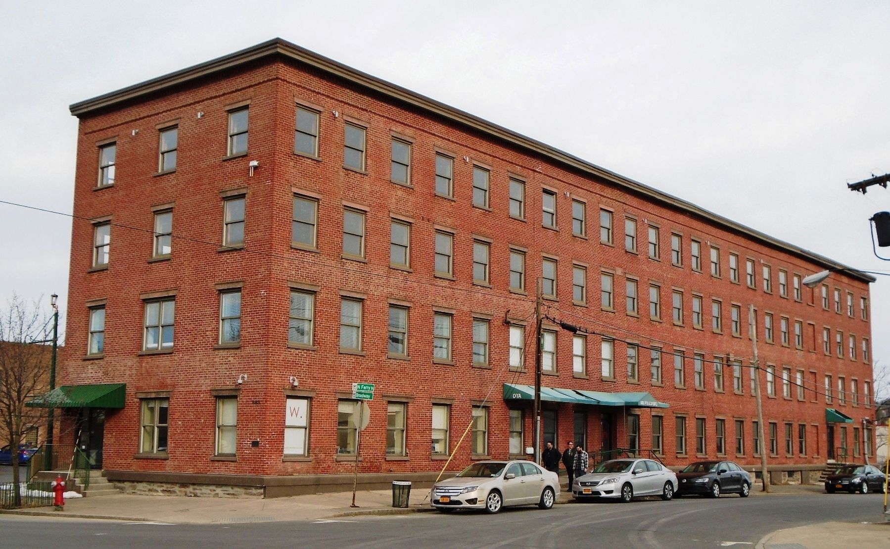
On Broadway at Ferry Street, on the right when traveling east on Broadway.
Built as the Boardman & Gray Piano Factory in 1853, it later became the Regent Shirt Factory, then the offices of the Brandow Printing Co. — — Map (db m115701) HM
On Meeting House Road, on the left when traveling north.
The Brethren's Shop was used by the men and boys for various crafts including shoe making and tinsmithing. The porches and dormers were added in 1930 and the building is now used by Albany County as offices.
A date stone in the basement is . . . — — Map (db m115662) HM
This brick building was used by the ministry elders. Each member of the ministry had to perform daily manual labor such as shoe making or tailoring. Elder Chauncey Copeley a cabinet maker, worked in a wing added to the building in 1850. . . . — — Map (db m115660) HM
The plants in this garden are some of the herbs used and sold by The Watervliet Shaker Community during the 1800's. The community grew large "Botanical/Physic" gardens and also gathered many wild herbs for use in their business of selling dried . . . — — Map (db m115658) HM
On this location was a large 3 1/2 sto[r]y stone building. Here Shaker Sisters did spinning, weaving, and sewing. Journal entries indicate that Sister Polly wove 3350 Shaker bonnets in this building.
The building was the only stone building . . . — — Map (db m115656) HM
On Commerce Avenue, on the right when traveling west.
Site Of
The New York Central
Railroad erector shop where
Engine 999 was built in 1893.
'999' was the first creation
of man in the history of time
to Travel 100 Miles per Hour
— — Map (db m32251) HM
On Meeting House Road, on the left when traveling east.
Shaker Creek provided water for both the canning and laundry operations. The first laundry, done on December 12, 1859, used a steam powered washing machine. Albany County used the building for laundry until the mid 1980s. Today it is a workshop. . . . — — Map (db m115674) HM
Near Ten Broeck Place north of Ten Broeck Street, on the left when traveling east.
Abraham Ten Broeck (1734-1810) built this grand mansion in the Federal style after the destruction of his family home on Broadway in the great fire of 1797.
Descended from one of Albany's founding New Netherland families, he was a businessman, . . . — — Map (db m139507) HM
Near North Pearl Street (New York State Route 32) south of Columbia Street, on the right when traveling north.
The City of Albany Salutes
B. Lodge & Co.
”Albany’s Oldest Store”
Established 1867
Presented by
Mayor Gerald D. Jennings
January 11, 1999
— — Map (db m116738) HM
On State Street (New York State Route 5) east of Eagle Street, on the right when traveling east.
This section of State Street is arguably the oldest continuously operating commercial avenue in the United States.
What began as a path in the woods cut by Native peoples and Dutch beaver trappers and traders became the main east-west . . . — — Map (db m116688) HM
On Broadway at Maiden Lane, on the right when traveling north on Broadway.
Why is Albany Here?
Mohawk and Mahican peoples inhabited this region for thousands of years when the Dutch ship the Half Moon dropped anchor near this spot in 1609.
At that time, the world was in the midst of a "Little Ice . . . — — Map (db m116700) HM
On New York State Route 143 at County Route 111, on the left when traveling west on State Route 143.
1818 Ephraim Andrews acquires cloth dressing and wool carding mills. By 1850 John E. Andrews establishes a straw paper making mill — — Map (db m131759) HM
In 1887, Charles V. Beebe received a patent for an easy riding, swing attachment for farm equipment seats. In 1891,he moved to Altamont and opened a harness shop in the Ostrander Building, in what is now 125 Maple Avenue. In 1895, . . . — — Map (db m131475) HM
On Maple Avenue (New York State Route 146), on the left when traveling north.
In 1879, James Ostrander bought a large lot on Church Street, and built a thriving shoe business. In 1882, he sold a portion of the lot to Charles Taber, who opened a tin shop on the site. Both businesses were lost in the 1886 fire, . . . — — Map (db m131455) HM
On Main Street (New York State Route 156), on the right when traveling west.
On 2 April 1864, David Becker purchased an acre of land from Conrad Crounse for $400, along the newly laid railroad tracks. On this land, Silas Hilton and Benjamin Crounse built a dry goods store, with rooms to let upstairs. The . . . — — Map (db m131500) HM
On Maple Avenue (New York State Route 146), on the left when traveling north.
Henry Lockwood built the first carriage factory in Knowersville in 1874. The VanBenscoten brothers and Charles B. Warner operated the business until the April 1886 Great Fire consumed the original building and much of the stock. . . . — — Map (db m131468) HM
On Main Street (New York State Route 156) at Altamont Boulevard (New York State Route 156), on the left when traveling north on Main Street.
George Severson (1766-1813), a grandson of Jurrian Severson, one of the area's first settlers, built the Wayside Inn ca. 1785 along the wagon track that is now Main Street. The site of the Inn was approximately half way between the . . . — — Map (db m145191) HM
On Delaware Turnpike (New York State Route 443), on the left when traveling west.
Built c. 1828 for Adam A. Clark and wife Betsy. Clarksville named in his honor Apr. 16, 1833. First Clarksville postmaster 1826-1841. Local innkeeper. — — Map (db m142470) HM
On Delaware Avenue, on the left when traveling north.
Peebles Island State Park is located in the city of Cohoes (Albany County) and the village of Waterford (Saratoga County). Surrounded by the third and fourth branches of the Mohawk River, this 191-acre park includes Polrump, Goat, and Peebles . . . — — Map (db m115377) HM
On Delaware Avenue, on the left when traveling north.
Cluett, Peabody & Co., a Troy-based manufacturer of men's collars and shirts, purchased Peebles Island in 1909. The abundant water, existing rail lines, and proximity to the company's Troy factory made the island an ideal location for treating . . . — — Map (db m115364) HM
On Ontario Street (Route 470) at Moose Lane, on the right when traveling east on Ontario Street.
First building erected for the
manufacture of knit goods by
power in America, 1836. First
power knitting machinery
applied in Cohoes, 1832 — — Map (db m11392) HM
On Ontario Street (Route 470) at Moose Lane, on the right when traveling east on Ontario Street.
First Power Mill
- for the -
Manufacture of Knit Fabrics
————————
Erected in 1843, By Egberts & Bailey
Inventors of the Power Knitting
Machine in 1832.
· · . . . — — Map (db m11350) HM
On Cohoes-Crescent Road, on the right when traveling north.
The present day hydroelectric power plant located at this site is owned and operated by the New York
Power Authority. It was constructed in 1908 when the Mohawk River was dammed, the Waterford Flight
of Locks was constructed, and the Erie Canal . . . — — Map (db m138991) HM
On Delaware Avenue, on the left when traveling north.
During the Revolutionary War, American troops camped on Van Schaick and Peebles Islands. Thaddaeus Kosciuszko, a prominent Polish engineer who aided the American cause, designed the earthworks that are visible today near the bridge to Waterford. . . . — — Map (db m115385) HM
On Delaware Ave., on the right when traveling north.
The Matton Shipyard
John E. Matton built his shipyard here on Van Schaick Island in 1916, shortly after the new Barge Canal opened. Besides building barges and tugboats, the shipyard serviced and repaired the boats that travelled both the . . . — — Map (db m48282) HM
On 2nd Avenue (New York State Route 32) north of 26th Street, on the right when traveling north.
This Greek-revival building was one of several weigh stations along the Canal used to levy the tolls for barges carrying merchandise and farm goods.
Until 1850 freight cargoes were measured by the displacement theory, but this hydraulic type . . . — — Map (db m40999) HM
On Foundry Road, on the right when traveling north.
Begun 1785 by Leonard De
Neuville. Known as Albany
Glass House, later Hamilton
Glass Wks. Made bottles &
window glass. Closed 1815
— — Map (db m50620) HM
On Empire State Trail, on the right when traveling south.
This was once the site of Troy Steel and Iron Company's blast furnace on Beeaker or Hillhouse Island. This island no longer exists; the tidal waters forming several islands on the west shore of the Hudson River were mostly filled in the 1960's with . . . — — Map (db m226374) HM
On River Road (New York State Route 144) 0.1 miles south of Simmons Road, on the right when traveling north.
The Mohican Indians and
their ancestors lived in this
area along the Hudson.
River where the ocean tides
flowed. The name
Moh-He-Con-Nuck means
"People of the
Waters That Are
Never Still"
The Grandfather by artist
Len Tantillo, is set in . . . — — Map (db m230106) HM
On Grove Street at South Main Street (County Route 201), on the right when traveling west on Grove Street.
Site Of
GROVE HOTEL
Est. By "Coon" Fryer Ca. 1874
Famed Countywide: Dances,
Picnics, Baseball, Racing,
Honeymoons. Slept 50.
1886 Room Cost $1.50 Day
— — Map (db m146506) HM
On Broadway at 15th Street, on the right when traveling south on Broadway.
The land now occupied by the City of Watervliet is part of a tract purchased by the first Patroon, Kiliaen van Rensselaer in 1630 from the Mohican or River Indians. The tract was within a large area on the west side of the Hudson River named Wely's . . . — — Map (db m58228) HM
On Broadway near 15th Street, on the right when traveling south.
10 Pounder Rifle
From Watervliet Arsenal Designed
By Robert P. Parrott and Cast at
The West Point Foundry.
Used by the Union Forces These
Guns were Mounted on Carriages
Made at Watervliet Arsenal Where
Ammunition was also Made. This . . . — — Map (db m7299) HM
On Broadway north of 15th Street, on the right when traveling south.
The Meneely Bell Foundry was established in 1826 by Andrew Meneely, a former apprentice in the foundry of Julius Hanks. Meneely was one of the greatest bell makers in American History. More than 65,000 bells were cast under the Meneely brand . . . — — Map (db m182363) HM
Meneely Foundry
1826 - 1950 First Chime &
Carillon in U.S. Cast Here
Foremost Bell Maker
Patented Rotary Yoke And
Casting Procedures.
— — Map (db m40322) HM
On New York State Route 143 at Switzkill Road, on the left when traveling north on State Route 143.
Built c. 1830. Family run
store, post office, tin shop
gas station c. 1850 -1943.
Long tenured postmaster
C.F. Anderson 1910 -1943. — — Map (db m135157) HM
On New York State Route 143, on the left when traveling west.
Three-floor hotel here 1800’s.
Owned by Henry Latham 1876-84.
Destroyed by fire 1897. Rebuilt
two-floor hotel Haverly House.
Later apartments. Razed c. 1953. — — Map (db m135156) HM
On Petrolia Road, 0.1 miles east of Stony Lonesome Hollow Road, on the right when traveling west.
Driller & contractor from PA, who earned nickname of "Dry Hole Ben" by seldom promoting successful oil wells. His continued faith in paying quantities of oil in Allegany County let him drill many historical wells. Including the "Wildcat Well" on . . . — — Map (db m65539) HM
On Main Street (New York State Route 417) at Liberty Street, on the right when traveling south on Main Street.
The presence of oil in this area of the Allegheny foothills has been known by white men since 1627, when a French missionary reported that the Indians used "a good kind of oil" for medicinal purposes from the nearby Seneca Oil Spring. Production . . . — — Map (db m88286) HM
On Oil Springs Road, 0.2 miles east of Cuba Lake Road (County Route 50), on the left when traveling east.
1627 Seneca Oil Spring 1927 Forms the first chapter in the development of the petroleum industry in America - a gigantic world enterprise transforming modern life. 1627 Oil in American continent first recorded in this region by the Franciscan . . . — — Map (db m86604) HM
Near Main Street (New York State Route 275) at Richardson Avenue.
Stands a monument marking the site of the first commercial well in the Richburg Oil Field. Completed April 27, 1881. This marker was erected by local oil producers and the site provided by the Richburg Board of Education. — — Map (db m88333) HM
On North Main Street, 0.1 miles south of East Pearl, on the right when traveling south.
David A Howe, born in West Almond, was raised in Wellsville and attended Dickenson Seminary (present day Lycoming College) in Williamsport, PA. He worked in Wellsville before moving to the Williamsport area where he was involved in many business . . . — — Map (db m170713) HM
On East Pearl Street at Depot Street, on the left when traveling east on East Pearl Street.
Perhaps nothing contributed more to the growth of Wellsville than the arrival of the Erie RR in 1851. The railroad brought many new families and businesses to our area and the population almost doubled in size. The old depot was on Loder Street at . . . — — Map (db m175134) HM
On South Main Street just north of West Dyke Street, on the left when traveling north.
From 1845 to 1905, Wellsville was home to several tanneries that were reported to be the largest in the world. They provided work for hundreds of people in lumbering and tanning. Hemlock bark was used in the tanning process and was stacked in huge . . . — — Map (db m175132) HM
On North Main Street at West Pearl, on the right when traveling south on North Main Street.
William F Jones, an attorney, banker, and prominent businessman, and his wife Gertrude F. Jones will always be remembered for their generous gift, which made today's Jones Memorial Hospital, a reality. In 1920, they bequeathed their stately home for . . . — — Map (db m170717) HM
Near Jungle World Road south of Bronx River Parkway, on the right when traveling south.
These are the actual remains of a 35-year-old male elephant who was poached for his ivory in 1989. We have been working to ensure fewer African elephants suffer the same fate.
A Cautious Comeback
Although some are now protected in . . . — — Map (db m193279) HM
On City Island Avenue north of Rochelle Street, on the right when traveling north.
It was in 1966 that the Sammy's Fixbox story began from our very humble beginnings in 1966 we have grown from a 26 seat snack bar to 500 seat, full service restaurant: preparing upwards of 1 million meals annually. Our phenomenal grouth . . . — — Map (db m226279) HM
On East 140th Street just west of Brook Avenue, on the right when traveling east.
This playground is named for the Saw Mill Creek, also known as the Mill Brook, which once flowed by this parkland. The creek originated in Gates Place in the North Bronx, ran along what is now Brook and Webster Avenues, and emptied into the Bronx . . . — — Map (db m209723) HM
Near Exterior Street, 0.2 miles north of East 150th Street, on the right when traveling south. Reported unreadable.
The Bronx Terminal Market served as the distribution point for thousands of food products satisfying the varied tastes of New Yorkers.
The Market was Open to Everyone
The Bronx Terminal Market served communities in the Bronx . . . — — Map (db m241552) HM
Near Exterior Street, 0.3 miles north of East 150th Street, on the right when traveling south.
The Power House, an engineering marvel of the 1920s, housed mechanical equipment vital to the operations of the Bronx Terminal Market.
The Power House
The only building remaining on the site of the Bronx Terminal Market, the . . . — — Map (db m241540) HM
Near Exterior Street north of East 150th Street, on the left when traveling north.
The Bronx Terminal Market's road, rail, and water links brought vast amounts of food into New York City.
Delivery Trucks at the Market
Trucks were a constant fixture at the Bronx Terminal Market. The long rows of narrow stores . . . — — Map (db m241555) HM
Built by Cornelius & Barbara Bevier circa 1850. Purchased 1889 by Otsego County native & Civil War veteran William Wright for 3,000.00. W. E. Wright was a carpenter, general contractor & proprietor of two stove & tinware stores in Binghamton. . . . — — Map (db m94390) HM
The valleys of the Upper Susquehanna River were natural routes for Indians, traders and settlers. Oquaga, near Windsor, was an Indian fur-trading post, and became an objective of the Sullivan-Clinton Campaign of 1779. From a dam at the outlet of . . . — — Map (db m35164) HM
On West Main Street (New York State Route 17C), on the right when traveling west.
Built 1829-30 by C.E. and W.H. Keeler. Second store in Union Corners. Now oldest. Slated for demolition, but saved and restored 1987. — — Map (db m141708) HM
On New York State Route 26, on the left when traveling north.
Grist mill founded ca. 1830
by H.B. & Daniel Slosson.
Owned by A. Pitcher 1920-1949,
closed in 1955. Donated to
historical society in 1988. — — Map (db m132753) HM
Parkway style highway
built 1941. Completed 1951.
Led to rapid development
along what became Vestal's
"$50 Million Main Street." — — Map (db m133061) HM
On Rock City Road (New York State Route 16) 0.5 miles east of Knapp Creek Road, on the left when traveling east.
The Settlement of Knapp Creek, formerly known as Knapps Creek, was a genuine boomtown in the early days of the Bradford Oil Field, beginning about 1877. It was on a narrow gauge railroad and later an electric street car line. The town boasted a . . . — — Map (db m60154) HM
On Bank Street at Main Street, on the right when traveling west on Bank Street.
State Bank of Randolph opened here July 1, 1874 with $65,000 capital stock invested by 14 shareholders. Operated over 100 years. — — Map (db m171598) HM
On Genesee Street, 0.1 miles west of Columbus Street, on the right when traveling west.
Columbian Rope Plant Founded by Col. E.D. Metcalf. New factory begun in 1903. 1 million sq. feet of floor area. "The Cordage City" — — Map (db m88099) HM
On South Street (New York State Route 34) at Fitch Street, on the right when traveling south on South Street.
David Munson Osborne Born 1822 - Died 1886 Lived here - House demolished 1936. Founded D.M. Osbourne Company manufacturer of harvesting machines. Mayor of Auburn, 1879-1881 Thomas Mott Osbourne Born 1859 - Died 1926 Lived here - House . . . — — Map (db m88470) HM
On South Street at Lincoln Street, on the left when traveling north on South Street.
Women's educational and industrial union, est. 1882. Inspired working women to join suffrage movement. Building opened on this site in 1907. — — Map (db m223757) HM
On Clark Street at North Division Street, on the right when traveling west on Clark Street.
For nearly 200 years, water power along the Owasco River in Downtown Auburn
has been at the foundation of the community's manufacturing, industrial, and
economic growth. Historically, there were over 11 sites harnessing the power of the river to . . . — — Map (db m145774) HM