By William Fischer, Jr., March 20, 2018
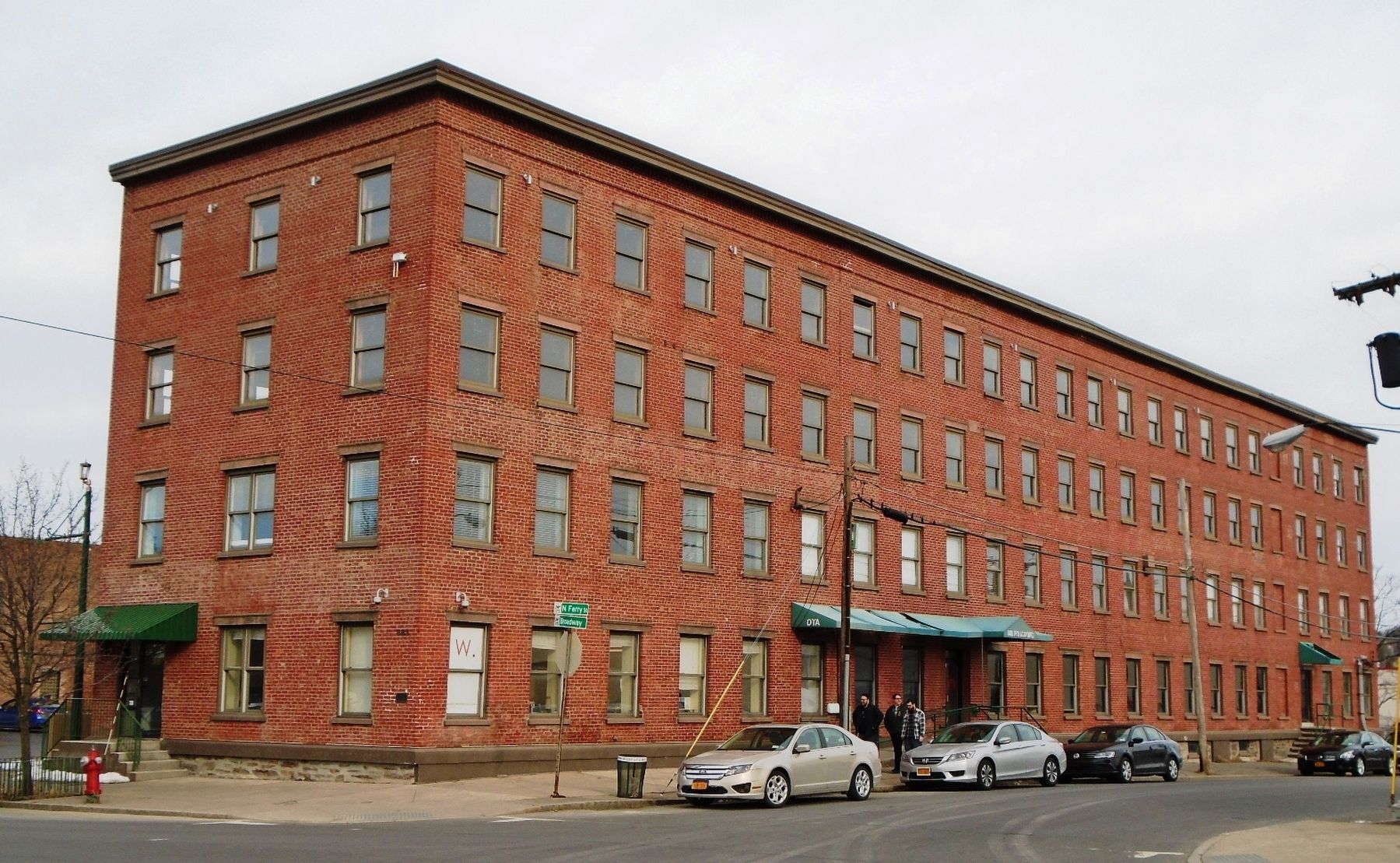
Boardman & Gray Piano Factory and Marker
| On Broadway at Ferry Street, on the right when traveling east on Broadway. |
| On Meeting House Road, on the left when traveling north. |
| On Broadway east of Ferry Street, on the right when traveling east. |
| On Commerce Avenue, on the right when traveling west. |
| On Meeting House Road, on the left when traveling east. |
| Near Ten Broeck Place north of Ten Broeck Street, on the left when traveling east. |
| Near Ten Broeck Place north of Ten Broeck Street, on the left when traveling east. |
| On Delaware Avenue (New York State Route 443) at Southern Boulevard (U.S. 9W), on the right when traveling south on Delaware Avenue. |
| Near North Pearl Street (New York State Route 32) south of Columbia Street, on the right when traveling north. |
| On State Street (New York State Route 5) east of Eagle Street, on the right when traveling east. |
| On Broadway at Maiden Lane, on the right when traveling north on Broadway. |
| On New York State Route 143 at County Route 111, on the left when traveling west on State Route 143. |
| On Maple Avenue (New York State Route 146), on the left when traveling north. |
| On Western Turnpike (U.S. 20) at Dunnsville Road (New York State Route 397), on the right when traveling west on Western Turnpike. |
| On Main Street (New York State Route 156), on the right when traveling west. |
| On Altamont Blvd (New York State Route 156), on the right when traveling east. |
| On Maple Avenue (New York State Route 146), on the left when traveling north. |
| On Main Street (New York State Route 156) at Altamont Boulevard (New York State Route 156), on the left when traveling north on Main Street. |
| On Berne-Altamont Road (New York State Route 156), on the right when traveling south. |
| On Berne-Altamont Road (New York State Route 156) 0.4 miles north of New York State Route 443, on the right when traveling north. |
| On Berne-Altamont Road (New York State Route 156), on the right when traveling south. |
| On Delaware Turnpike (New York State Route 443), on the left when traveling west. |
| On Delaware Avenue, on the left when traveling north. |
| On Delaware Avenue, on the left when traveling north. |
| On Ontario Street (Route 470) at Moose Lane, on the right when traveling east on Ontario Street. |
| On Ontario Street (Route 470) at Moose Lane, on the right when traveling east on Ontario Street. |
| On Cohoes-Crescent Road, on the right when traveling north. |
| On Delaware Avenue, on the left when traveling north. |
| On Delaware Ave., on the right when traveling north. |
| On 2nd Avenue (New York State Route 32) north of 26th Street, on the right when traveling north. |
| On 2nd Avenue (New York State Route 32) north of 26th Street, on the right when traveling north. |
| On Main Street, on the right when traveling north. |
| On Indian Fields Road (New York State Route 32) at Railroad Avenue, on the right when traveling west on Indian Fields Road. |
| On Van Wies Point Road south of Wheeler Road, on the left when traveling south. |
| On Western Avenue (U.S. 20) east of New York State Route 146, on the right when traveling east. |
| On Western Ave (U.S. 20) at French's Mill Road, on the right when traveling east on Western Ave. |
| On Foundry Road, on the right when traveling north. |
| On Western Turnpike (U.S. 20), on the right when traveling west. |
| Near Berne-Altamont Road (New York State Route 156), on the right when traveling east. |
| On Empire State Trail, on the right when traveling south. |
| On New York State Route 145, on the left when traveling south. |
| On County Route 351 near Albany Hill Road (County Route 361), on the right when traveling east. |
| On River Road (New York State Route 144) 0.1 miles south of Simmons Road, on the right when traveling north. |
| On Grove Street at Voorheesville Avenue (County Route 306), on the left when traveling east on Grove Street. |
| On Grove Street at South Main Street (County Route 201), on the right when traveling west on Grove Street. |
| On Maple Avenue (New York State Route 85A) east of Stonington Hill Road, on the right when traveling east. |
| On Broadway at 15th Street, on the right when traveling south on Broadway. |
| On Broadway near 15th Street, on the right when traveling south. |
| On 2nd Avenue (New York State Route 32) at 23rd Street, on the right when traveling north on 2nd Avenue. |
| On Broadway at Fifth Street, on the left when traveling south on Broadway. |
| On Broadway north of 15th Street, on the right when traveling south. |
| On Broadway, on the right when traveling south. |
| On what had been Broadway, now Empire State Trail (New York State Route 32), on the right when traveling south. |
| On New York State Route 143 at Switzkill Road, on the left when traveling north on State Route 143. |
| On New York State Route 143 at Myers Road, on the right when traveling west on State Route 143. |
| On New York State Route 143, on the left when traveling west. |
| On County Route 405, 0.1 miles south of Creamery Road, on the right when traveling north. |
| On Petrolia Road, 0.1 miles east of Stony Lonesome Hollow Road, on the right when traveling west. |
| On Main Street (New York State Route 417) at Liberty Street, on the right when traveling south on Main Street. |
| On New York State Route 19 at Leonard Ave, on the right when traveling south on State Route 19. |
| On Oil Springs Road, 0.2 miles east of Cuba Lake Road (County Route 50), on the left when traveling east. |
| On Bill Allen Hill Road, 0.4 miles west of Petrolia Road, on the right when traveling west. |
| Near Main Street (New York State Route 275) at Richardson Avenue. |
| On Agett Road, 0.8 miles north of Hardys Corners Road (County Route 7B), on the right when traveling north. |
| On North Main Street, 0.1 miles south of East Pearl, on the right when traveling south. |
| On East Pearl Street at Depot Street, on the left when traveling east on East Pearl Street. |
| On South Main Street just north of West Dyke Street, on the left when traveling north. |
| On North Main Street at West Pearl, on the right when traveling south on North Main Street. |
| Near Jungle World Road south of Bronx River Parkway, on the right when traveling south. |
| On City Island Avenue north of Rochelle Street, on the right when traveling north. |
| On East 140th Street just west of Brook Avenue, on the right when traveling east. |
| Near Exterior Street, 0.2 miles north of East 150th Street, on the right when traveling south. Reported unreadable. |
| Near Exterior Street, 0.3 miles north of East 150th Street, on the right when traveling south. |
| Near Exterior Street north of East 150th Street, on the left when traveling north. |
| On Front Street (U.S. 11) at Main Street, on the right when traveling west on Front Street. |
| Near Interstate 81 at milepost 1. |
| On 2nd Street, on the right when traveling west. |
| On Front Street at River Street, on the left when traveling north on Front Street. |
| On West Main Street (New York State Route 17C), on the right when traveling west. |
| On New York State Route 26, on the left when traveling north. |
| On Main Street, on the right when traveling north. |
| On Main Street, on the left when traveling north. |
| On West Shore Road (County Route 50) at Cuba Maplehurst Road (New York State Route 446), on the right when traveling south on West Shore Road. |
| On Rock City Road (New York State Route 16) 0.5 miles east of Knapp Creek Road, on the left when traveling east. |
| On Fair Oak Street (New York State Route 242) at Virginia Avenue, on the right when traveling east on Fair Oak Street. |
| On Bank Street at Main Street, on the right when traveling west on Bank Street. |
| On State Street (New York State Route 38) at Wall Street, on the left when traveling north on State Street. |
| On Genesee Street, 0.1 miles west of Columbus Street, on the right when traveling west. |
| On South Street (New York State Route 34) at Fitch Street, on the right when traveling south on South Street. |
| On Genesee Street at Columbus Street, on the right when traveling west on Genesee Street. |
| On Genesee Street west of South Street (New York State Route 34), on the left when traveling west. |
| On South Street at Lincoln Street, on the left when traveling north on South Street. |
| On Clark Street at North Division Street, on the right when traveling west on Clark Street. |
1820 entries matched your criteria. The first 100 are listed above.
Next 100 ⊳