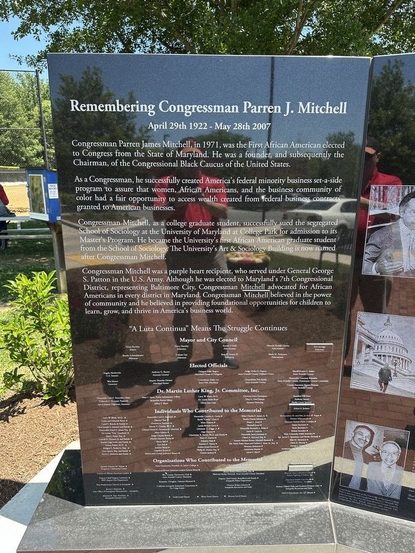
On Hilltop Lane, on the right when traveling west.
Congressman Parren James Mitchell, in 1971, was the First African American elected to Congress from the State of Maryland. He was a founder, and subsequently the Chairman, of the Congressional Black Caucus of the United States.
Patented August 25, 1664, to Edward, Joshua, and John Dorsey, sons of Edward Dorsey who settled in Maryland in 1650. The patent was signed by Charles Calvert, then Lieutenant General, and later Third Lord Baltimore. This plantation has been the . . . — — Map (db m2906) HM
On Mt. Zion Marlboro Road (Maryland Route 408) 0.1 miles west of Ed Prout Road, on the right when traveling west. Reported damaged.
On June 19, 1863, during the War Between the States (1861-65), Private Owens of the 1st Maryland Artillery, Confederate States of America, performed heroically at the Battle of Stephenson's Depot. Owens, born and raised in West River, Anne Arundel . . . — — Map (db m152513) HM
On Mt. Zion Marlboro Road (Maryland Route 408) 0.1 miles west of Ed Prout Road, on the right when traveling west.
This monument, dedicated on June 17, 1999, honors the memory of a local man, Benjamin Welch Owens, who left his nearby West River farm to join Confederate forces during the Civil War. Owens was among the tens of thousands of men from Maryland who . . . — — Map (db m22146) HM
On Gervais Street (U.S. 1) near Williams Street, on the right when traveling east.
Williams Street. This street was named for Otho H. Williams, Brig. Gen. Of Continental Army during the American Revolution. Williams served as adjutant general under Southern Army commanders Gates and Greene and saw military action in the . . . — — Map (db m11247) HM
Near West Street (Maryland Route 450) at Brewer Avenue.
The record of lynchings in Maryland from 1891-1906
May 13, 1891 - Asbury Green, Centerville
May 17, 1892 - James Taylor, Chestertown
June 8, 1893 - Isaac Kemp, Princess Anne
October 20, 1894 - Stephen Williams, Prince George's County . . . — — Map (db m53171) HM
Near Old Muirkirk Road. Reported permanently removed.
Iron Production: Maryland’s Industrial Past
Maryland’s early economy and identity were based on slave-based agriculture. However, slaves were also employed in manufacturing iron, one of the first non-agricultural industries. Seeing how other . . . — — Map (db m104641) HM
During 2001-2004, Anne Arundel County’s Lost Towns Project conducted excavations in the neighboring community of Leitch in search of the lost town of Herrington (c. 1660), one of Maryland’s earliest legislated port towns. Established by the Maryland . . . — — Map (db m79981) HM
On Main Street at Compromise Street, on the left when traveling south on Main Street.
To commemorate the arrival in this harbor of Kunte Kinte, immortalized by Alex Haley in Roots, and all others who came to these shores in bondage and who by their toil, character and ceaseless struggle for freedom have helped to make these . . . — — Map (db m5572) HM
On Walnut Drive north of Bay Highlands Drive, on the right when traveling north.
In 1892, Major Charles Douglass, youngest son of Frederick Douglass, and Charles' wife Laura, were turned away from a restaurant at the Bay Ridge Resort and Amusement Park because of their race. The resort was separated by a narrow channel—the . . . — — Map (db m288638) HM
On Jonas Green Park Road, on the left when traveling south.
In 1649, a group of "non-conformist" Puritans landed on the shores of Whitehall Bay, fleeing religious persecution in Virginia and seeking new opportunities in Lord Baltimore's colony of Maryland. These devout Protestants took up land that had been . . . — — Map (db m221301) HM
On Veterans Highway 0.4 miles south of Benfield Road, on the right when traveling south.
Adam Shipley, who came to Anne Arundel County in 1668, on March 30, 1681, patented 200 acres on the south side of the Severn River. Dedicated during the Tercentenary Commemoration of the Shipleys of Maryland. May 25, 1968. — — Map (db m265122) HM
On Veterans Highway 0.5 miles south of Benfield Road, on the left when traveling south.
Adam Shipley, who came to Anne Arundel County in 1668, on March 30, 1681, patented 200 acres on the south side of the Severn River. Dedicated during the Tercentenary Commemoration of the Shipleys of Maryland. May 25, 1968. — — Map (db m80457) HM
Near Solomons Island Road South (Maryland Route 2) just south of Thomas Johnson Road, on the left when traveling south.
The hull fragment from an unidentified bugeye was recovered from the Magothy River in Anne Arundel County, Maryland. The fragment forms part of the bottom of a seven- or nine-log bugeye of early vintage. Clearly evident is the slot in the center log . . . — — Map (db m138588) HM
Near West Street (Maryland Route 450) just west of Chinquapin Round Road, on the right when traveling east.
The Civil War
The Civil War had a major impact on the people of Anne Arundel County. As a border state, Maryland was home to both Confederate and Union sympathizers. Like Baltimore, Annapolis was occupied by Union troops during the Civil . . . — — Map (db m232510) HM
On Furnace Avenue at Riverwatch Avenue, on the right when traveling north on Furnace Avenue.
Origins of Elkridge
The first mention of the Elkridge Hundred can be found in the 1702 Baltimore County Tax List. In 1733, the Maryland Assembly passed an act authorizing the establishment of a town, called "Jansen-Town," located "at and about . . . — — Map (db m150573) HM
On Old Muirkirk Road 0.2 miles north of Muirkirk Road, on the right when traveling north.
Iron Production: Maryland's Industrial Past
Maryland's early economy and identity were based on slave-based agriculture. However, slaves were also employed in manufacturing iron, one of the first non-agricultural industries.
One of the . . . — — Map (db m188081) HM
On College Avenue (Maryland Route 450) at Chruch Circle ( Route 450), on the left when traveling west on College Avenue.
To the memory of Rev. William Scott Southgate, for thirty years rector of Saint Anne's Parish in Anne Arundel County, Maryland. Born April 10, 1831. Died May 21, 1899.
Reverse side: Erected by the citizens of Annapolis and by his old . . . — — Map (db m9289) HM
On Piney Orchard Parkway, on the right when traveling north.
Odenton's history is directly connected to the development of railroads in western Anne Arundel County during the 1800s and early 1900s. The town was a busy transit hub for the Baltimore and Potomac Railroad (later the Pennsylvania Railroad) and . . . — — Map (db m272223) HM
The Memorial commemorates the arrival in Annapolis of Kunte Kinte, Alex Haley’s ancestor, as told in his book, Roots. That arrival was not a voluntary one. Kunte Kinte was one among one hundred-forty Africans forced into the hold of the slave . . . — — Map (db m6392) HM
Near Londontown Road 1.3 miles north of Mayo Road (Route 253). Reported permanently removed.
Scattered Settlements
Early Chesapeake Bay colonists did not settle in the concentrated villages typical of their home in England. Instead, they lived on large plots of waterfront land that isolated them from their neighbors.
Cheap and . . . — — Map (db m22112) HM
On Londontown Road 1.3 miles west of Mayo Road (Route 253) when traveling west. Reported permanently removed.
Welcome
Historic London Town and Gardens is a 23-acre park where discover and learning are daily experiences. Here, a visitor will see and can often participate in the unfolding story of this once thriving colonial town.
Remains of the . . . — — Map (db m22140) HM
On St. Leonard Road (Maryland Route 765) 0.1 miles south of Calvert Beach Road, on the right when traveling south.
The Honorable Thomas Parran (1860-1955)
Thomas Parran, the St. Leonard citizen who played a key role in the construction of the St. Leonard Polling House, was born on February 12, 1860, on the Chestnut Hill Farm (see map) in St. Leonard . . . — — Map (db m181801) HM
On Waterloo Road (Maryland Route 108) at Richard Valley Road, on the right when traveling north on Waterloo Road.
The first large land grant in what is now Howard County. Patented October 1, 1687 to Adam Shipley who came to Maryland from England in 1668. This marks a section of the western boundary of the 500 acre grant. A Shipley family cemetery is located . . . — — Map (db m226102) HM
Near Hicks Avenue south of West Street ( Route 450), on the right when traveling south. Reported damaged.
Blacks first became eligible to vote and hold office in 1870 in the City of Annapolis. Since that time only 24 or 14% have been Black elected officials. Of those 24, only 7 have served the Parole Community in Annapolis.
The predominantly . . . — — Map (db m232498) HM
On Muddy Creek Road 0.1 miles east of Galesville Road, on the right when traveling east.
Cedar Park
Patented to Richard Ewen in 1666 as “Ewen upon Ewenton.” Brick house built c.1697 by Richard Galloway II around earlier frame structure possibly dating back to 1656. Known as “West River Farm” in 18th Century. Home and burial place . . . — — Map (db m65889) HM
Despite beginning their lives enslaved at nearby farms, Henry and Catharine "Kitty" Wilson
became some of the first Black property owners in the Galesville region when they bought two
acres in 1865. By 1871, they had added 26.5 acres of land to . . . — — Map (db m301069) HM
On Solley Road 1.6 miles south of Fort Smallwood Road ( Route 173), on the right when traveling south.
This historic school is a significant example of a Rosenwald School design and represents a landmark era in black education in the period before federal support of local education. The school was built in 1927 with funds raised by the local . . . — — Map (db m9035) HM
On Queenstown Road 0.1 miles south of Kearneys Lane, on the right when traveling north.
Built in 1932 on land provided by Sarah and Oscar Gaither, this three-room school, rare for the area, was the last Rosenwald school built in this county. After school consolidation, the building housed the Sunnyside School and later the Quarterfield . . . — — Map (db m244473) HM
On East West Shady Side Road west of Bast Avenue when traveling north.
I haven't seen 15 bushels of clams in so long... You do worse more days than you do better. Nature can't put it back as fast as man takes it away.
— Ellsworth Brown, clammer, age 55 (1977)
Eeling
Bay . . . — — Map (db m130006) HM
On Solomons Island Road South north of Charles Street, on the right when traveling south.
The name "Patuxent" is the diminutive for "Pautuckese," translated means "at the little falls" or "at the falls or rapids." In 1612, Captain John Smith named the river after one of the Werowances villages located along Battle Creek in Calvert . . . — — Map (db m287633) HM
Near Solomons Island Road South (Maryland Route 2) south of Thomas Johnson Road, on the left when traveling south.
Ernest H. "Dick" Hartge started building boats at Galesville, on the West River in Anne Arundel County, Maryland, in the 1920s. He later acquired a fleet of hire boats built and formerly owned by Ed Leatherbury of nearby Shadyside. Hartge moved to . . . — — Map (db m138600) HM
Near Westlake Drive 0.4 miles north of Westlake Terrace, on the right when traveling south.
Dean Albany co-founded the Cal Ripken Sr. Collegiate Baseball League in 2005, giving the league instant credibility with college coaches and major league scouts. As a coach of Youse's Orioles, Dean's teams won six All-American Amateur . . . — — Map (db m199013) HM
On O'Brien Road at Simmonds Street, on the right when traveling south on O'Brien Road.
Named for Marylander Colonel William D. Tipton, Tipton Army Airfield was constructed in 1960 to replace a smaller airstrip operating since 1938 near the present Post Exchange and Commissary complex.
COL Tipton served in both World Wars. During . . . — — Map (db m19704) HM
On Maryland 255 at Woodfield Road, on the right when traveling west on Maryland 255.
For over a hundred years, maritime industries have thrived on Tenthouse Creek. With direct
access to the West River and the Bay, businesses were established to harvest, process and sell oysters, fish and crabs from the waters of the Chesapeake Bay. . . . — — Map (db m301054) HM
Near Old Guilford Road 0 miles south of Guilford Road when traveling south.
River Facts
• The Little Patuxent River begins in Howard County near Alpha Ridge.
• It is joined by the Middle Patuxent River near Savage.
• It continues south to join the Patuxent River near Crofton in Anne Arundel County.
• The total . . . — — Map (db m20504) HM
On Generals Highway, on the right when traveling south.
Constructed in 1753, the Rising Sun Inn is a rare example of an intact 18th-century tavern and dwelling. Situated on historic Generals Highway, the Inn offered respite to weary travelers and their horses. This monument to 18th- and 19th-century . . . — — Map (db m272224) HM
On N. Camp Meade Rd (Maryland Route 170) 0.1 miles north of Maple Road. Reported missing.
Built circa 1820, the Benson-Hammond House is the headquarters of the Ann Arundell County Historical Society and is open to the public.
Annapolis and Baltimore Short Line
Organized in 1880, the Annapolis and Baltimore Short Line ran its . . . — — Map (db m253477) HM
Near Bembe Beach Road north of Edgewood Road, on the right when traveling north.
• 1902 Frederick Carr and his wife Mary Wells Carr purchased 180 acres of waterfront farmland on the Annapolis Neck. The family took in boarders and hosted picnics
• 1926 Opened Carrs Beach as a Chesapeake Bay/waterfront retreat . . . — — Map (db m288632) HM
Historical records of colonial Annapolis show that Richard Spriggs, an important 18th Century Annapolitan, had a house built on Strawberry Hill in 1780. By 1796 Spriggs had leased the house to Henri Stier, an investment banker from Antwerp, and his . . . — — Map (db m60913) HM
On West McKinsey Road 0.1 miles east of Baltimore Annapolis Boulevard ( Route 648), on the right when traveling east.
Lynching in America
Thousands of black people were the victims of racial terror lynching in the United States between 1877 and 1950. The lynching of African Americans during this era was a form of racial terrorism intended to intimidate . . . — — Map (db m225927) HM
On Lighthouse Boulevard east of Hemlock Drive, on the left when traveling east.
Calvert Cliffs
The Calvert Cliffs stretch more than thirty miles, from Drum Point, Calvert County, to Fairhaven, Anne Arundel County, rising in places to a height of more than 100 feet. The cliffs represent the eroded sides of the . . . — — Map (db m307391) HM
On West Street (Maryland Route 450) at Brewer Avenue, on the right when traveling west on West Street.
Growing up on South Street near the county courthouse, George Phelps' boyhood dream was to be a police officer. After WWII, Army 1st Lt. Phelps saw his dream come true when County Exective Joseph W. Alton appointed him, the first African . . . — — Map (db m53175) HM
This reproduction of the Liberty Bell was presented to
Maryland
by direction of
The Honorable John Snyder
Secretary of the Treasury
as the inspirational symbol of the United States savings bonds independence drive from May 15 to July 4 . . . — — Map (db m63419) HM
On Crownsville Road, on the right when traveling north.
In 2004, with just 200 patients left, the State closed Crownsville Hospital, leaving the future of the vast campus and its conflicting legacies in limbo. The campus, which is eligible for listing in the National Register of Historic Places, stood . . . — — Map (db m279577) HM
Near Londontown Road 1.3 miles north of Mayo Road (Route 253), on the right when traveling west. Reported permanently removed.
A Transportation Network
Ferries were a critical link in the colonial road system. The ferry crossing at London Town was part of a larger transportation network that extended from Virginia to New York, moving people and goods to market . . . — — Map (db m22143) HM
Near Londontown Road 1.3 miles north of Mayo Road (Route 253). Reported permanently removed.
Location, Location, Location
One of the mysteries that still surrounds the lost town of London is the William Brown House. Built between 1758 and 1764 overlooking the South River, William Brown intended it to serve as his dwelling and an . . . — — Map (db m22137) HM
On Galesville Road, on the right when traveling west.
The Galesville Hot Sox baseball team played on this sandlot from 1926 to 1986. Established in an era when recreational and professional sports were segregated, independent teams like the Hot Sox formed a cornerstone of African American community . . . — — Map (db m301072) HM
From 1948 to the 1960s, Rev. Hiram Smith and his family operated Beechwood Park, an integrated beach and amusement park. Located near the headwaters of the Magothy River, Beechwood offered swimming, boat rides, attractions, and entertainment to . . . — — Map (db m298883) HM
In 1889, business partners Gustav T. Hetschel and Henry Frost established a general store and post office just steps away from the Annapolis and Baltimore Short Line Railroad. This new rail service connected the state's economic and political . . . — — Map (db m239533) HM
On East West Shady Side Road west of Bast Avenue, on the right when traveling north.
Then I took up oystering, went on the water oystering, and, oh my, I stayed out there and worked, and worked, and worked.
— Julius Dennis, age 88 (1984)
Scooping and Raking — Tonging and Dredging
To . . . — — Map (db m130012) HM
Commons originated in England as open areas within settlements where people could graze their livestock. In colonial American, these areas became known as "village greens" where people assembled, troops drilled and games were played. Later, . . . — — Map (db m128068) HM
On Thomas Point Road 1 mile south of Gordon Cove Drive, on the right when traveling south.
Thomas Point
Part of the Bay Heritage
Much of the early history of Thomas Point still lies buried under sand and water at its ever-eroding shoreline. Evidence does exist, however, that Native Americans enjoyed the bounty of the Bay's . . . — — Map (db m288647) HM
The Dr. Martin Luther King, Jr. Memorial was given to Anne Arundel Community College by the Citizens of Maryland. May this memorial remind all that visit this site, that an individual can make a difference.
From this point, Conway Road begins to narrow as it winds its way east. The road comes to an end at the Amtrak rail line and the Patuxent Research Refuge's North Tract beyond. At the road's end was a small community established by Quakers in the . . . — — Map (db m273933) HM
Conway Road narrows as it winds its way east and comes to an end at the Amtrak rail line and the Patuxent River, with the Patuxent Research Refuge's North Tract beyond. It was here that Quakers established a meeting house and community in the 1790s. . . . — — Map (db m279510) HM
Thin black lines indicate changes in relevance. Between each pair of lines entries are ordered geographically but all have the same relevance.
* Inflectional forms of words are their plurals, singulars, and possessives as well as gramatical tenses and similar variations.