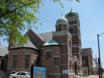
Established in 1789, the Portsmouth and Norfolk Baptist Church served as the first Baptist congregation in South Hampton Roads. The name was changed in 1791 to Portsmouth Baptist Church and again in 1855 to its current name, Court Street Baptist . . . — — Map (db m20467) HM
The intersection of High and Court Street was known as Towne Square, the cornerstone of the community. The square that you are standing on was known as Courthouse Square, the site of the original courthouse from 1803-1846. In 1855 the Ocean Hotel . . . — — Map (db m20463) HM
The Portsmouth Colored Community Library was the library for Portsmouth’s Black citizens from 1945 to 1962. The building serves as a reminder of the segregation when African-Americans could not use the “white’s only” public library. Thomas C. . . . — — Map (db m191677) HM
James Gaskins, Portsmouth's first silversmith from 1790 (circa) to 1827, lived and worked at the house at 316 North Street. Purchased in 1808, Mr. Gaskins resided here with his family and worked at his forge in a smith's shop separated from, but . . . — — Map (db m293217) HM
Convinced of the need to more quickly and efficiently repair the nation's Navy ships, President John Quincy Adams and Congress agreed in 1827 to follow engineers' recommendations to build two dry docks, one here and one in Boston.
The . . . — — Map (db m76838) HM
Following the evacuation and burning of the yard by Federal forces, Dry Dock 1 was used by the Confederate States Navy to convert the partly burned steam frigate Merrimack into an ironclad, renamed CSS Virginia.
In March 1862, the . . . — — Map (db m76839) HM
After the War of 1812, the shipyard helped repel an invasion of Craney Island and the USS Chesapeake was captured off Nova Scotia. Gosport continued to expand and improve. The keel of the USS Delaware was laid in the summer of 1817. . . . — — Map (db m76840) HM
Three prominent structures stand out along a one-block stretch of Portsmouth's Lincoln Street – Quarters A, B and C. On an 1827 map of the shipyard they are designated as the “Proposed Commandant's House,” the “Proposed Master Commandant’s House" . . . — — Map (db m76841) HM
Founded November 1767 under the British flag by Andrew Sprowle, a Scottish-born merchant, the Norfolk Naval Shipyard is the U.S. Navy's oldest, continuously operating shipyard and actually predates the United States Navy Department by nearly 30 . . . — — Map (db m76823) HM
Leased in 1794 by the federal government, as part of its response to acts of piracy by the Barbary States, the shipyard produced in 1798-99 the 36-gun frigate Chesapeake, a sister ship of the USS Constitution known as "Old Ironsides." . . . — — Map (db m76825) HM
Built between December 1939 and June 1940, this 20-story crane can lift 350 tons. The Hammerhead is the largest crane of its type in the world. Its uses have included lifting a tugboat from the water, hoisting 16-inch gun turrets onto battleships . . . — — Map (db m76826) HM
Dry Dock 2, first built of wood, was completed in November 1887, but rebuilt with concrete in 1933. Dry Dock 3 was completed in November 1903. Dry Dock 4 was opened on April 1, 1919, with the King and Queen of Belgium in attendance. Dry Dock 5 . . . — — Map (db m76827) HM
With the advent of the Spanish-American War, an era of wood and canvas gave way to steel and steam in naval shipbuilding. The first U.S. Navy battleship to be commissioned, the USS Texas, and the first modern cruiser, the USS . . . — — Map (db m76828) HM
World War I ushered in a new period of growth for the shipyard. Three new dry docks and a major ship building way were added, in addition to new shop facilities. With the focus on ship repairs, along with construction of destroyers and 110-foot . . . — — Map (db m76829) HM
The yard’s employment peak of 43,000 workers was reached during World War II when the yard bustled with activity, building nearly 30 major vessels and repairing 6,850 U.S. and Allied ships. The shipyard also built 20 tank-landing ships and 50 . . . — — Map (db m76830) HM
The outbreak of hostilities in Korea in 1950 increased the workload once again. The shipyard completed work on more than 1,250 naval vessels and also built its last two warships, the wooden-hulled minesweepers Bold and Bulwark. . . . — — Map (db m76835) HM
In 1907 President Theodore Roosevelt launched the "Great White Fleet" from the shipyard as it began its journey around the world.
Norfolk Naval Shipyard built the first flight deck on a ship, the USS Birmingham (CS-2). . . . — — Map (db m76836) HM
During USS Thomas Jefferson's 22 years of service, it was both a ballistic missile submarine and an attack vessel. Newport News Shipbuilding & Drydock Company built USS Thomas Jefferson, which was commissioned on January 4th, 1963. The . . . — — Map (db m76837) HM
Glasgow Street Park, a historic site and cemetery of Monumental United Methodist Church, holds the grave of Adj. William Ball Jr. He was one of a total of about 30 Monumental members and others, so buried at this site prior to the 1840s. . . . — — Map (db m301896) HM
The 1846 Courthouse building at the corner of Court & High Street in Olde Towne Portsmouth was designed in the classic Greek Revival style by architect, William R. Singleton and built by Willoughby G. Butler. It housed the Norfolk County Court until . . . — — Map (db m76790) HM
On June 19th, 1855, following a twelve day quarantine, the merchant ship Benjamin Franklin arrived from the West Indies and docked at Gosport Shipyard for repairs. While emptying its bilge, mosquitoes carrying yellow fever were released. After . . . — — Map (db m36892) HM
Naval Medical Center Portsmouth is known as the “First and Finest.” It was the nation’s first Naval Hospital and has served the military since 1830. The hospital complex is 112 acres and serves approximately 430,000 active duty service . . . — — Map (db m62263) HM
The Charette Health Care Center was dedicated in April 1999 and it is the third naval hospital built in Portsmouth. The 1 million square foot, five story, state-of-the-art hospital contains 17 operating rooms, 300 exam rooms, 120 beds, 140 special . . . — — Map (db m62279) HM
This memorial is dedicated to those Sailors and Marines from both sides of the Atlantic who have made the ultimate sacrifice in the defense of freedom.
Naval Medical Center Portsmouth VA — — Map (db m294324) WM
The United States purchases 310 acres formerly Afton & Prospect farms as one of its first planned housing developments. Afton, Prospect & Alywin streets form the shape of an anchor. The community is named in memory of British WWI hero RADM Sir . . . — — Map (db m247133) HM
After WWI transition from government to private ownership occurs in 1922 following a year of self government. Cradock becomes a part of Norfolk County and continues to prosper and grow. — — Map (db m247339) HM
Cradock survives The Great Depression. Medal of Honor Winner David D. Barrow feeds Cradock residents with fish from his market located in Afton Square. Barrow’s generosity is characteristic of his close-knit neighborhood. — — Map (db m247340) HM
Cradock supports the country through WWII and the Korean conflict. It witnesses the final days of its Trolley service. Cradock grows in size and graduates its first class of students from the new Cradock High School. — — Map (db m247695) HM
Portsmouth annexes Cradock and agrees to maintain the neighborhood’s post office, fire station, library, and schools. Portsmouth designates a portion of Cradock as historic, to preserve its rich history. — — Map (db m247696) HM
Cradock High School closes in 1992. The following year Cradock celebrates its Diamond Jubilee. On the eve of the new millennium, Cradock’s community organizations mobilize to ensure its revitalization. — — Map (db m247697) HM
The Cradock community mourns with the families of the 2,996-people killed, and supports the 6,000 injured during the attacks of September 11, 2001. The Cradock community, along with the nation, endures financial crisis in 2008. The financial . . . — — Map (db m247700) HM WM
Chevra T'helim, (translation: House of Psalms), housed an Orthodox Jewish Congregation, established in 1917. It served the religious needs of a congregation largely composed of merchants who emigrated from Eastern Europe th the port city of . . . — — Map (db m36890) HM
The four houses directly across the street are the last remaining original houses of Lincolnsville, Portsmouth's first middle-class African American community, established in 1890. It was an area of about 34 acres and operated as a city within a . . . — — Map (db m36911) HM
St. Paul's Roman Catholic Church was first built by French and Irish immigrants between 1811 and 1815 and was the first Catholic congregation established in Portsmouth. Increasing membership necessitated the building of new structures in 1831 and . . . — — Map (db m21147) HM
Cedar Grove Cemetery was established in 1831 as the first secular cemetery by the Town of Portsmouth. It was placed on the National Register of Historic Places in 1992. The four-acre parcel cost $400.00 and was sectioned into 167 lots which sold for . . . — — Map (db m119425) WM
Virginia seceded from the Union on April 17, 1861. On April 2, the Governor ordered the 3rd Virginia Regiment to occupy and fortify the Navy Hospital grounds. A battery of earthen works was hastily erected on the point and renamed Fort Nelson, after . . . — — Map (db m83920) HM
After the Spanish defeat at the battle of Santiago, Cuba, in July 1898, the sick and injured needed treatment. The newly converted hospital ship USS Solace transported 55 sick U.S. Navy and 48 wounded Spanish sailors to the hospital. The . . . — — Map (db m83924) HM
World War II created the need to rapidly expand the hospital in 1941. The $1.5 million program increased the number of hospital beds to 3,441. A dental clinic, ships service, library and a bank were added. The staff -- medical officers, nurses, . . . — — Map (db m83925) HM
By 1900, time and use had taken its toll on the hospital building. In October 1907, the Navy's Bureau of Medicine and Surgery ordered hospital personnel to remove patients to tent-covered wooden platforms constructed several hundred yards away from . . . — — Map (db m83926) HM
Building 215 was constructed to provide a much needed modern hospital and to centralize the medical departments scattered around the base. The 500-bed hospital became the command’s second primary hospital facility when commissioned in April 1960. . . . — — Map (db m83930) HM
On June 17, 1898, President William McKinley signed a bill establishing the Navy Hospital Corps. Navy Corpsmen are trained in the science of health and nursing skills necessary to provide proper patient care at hospitals, ships at sea and to the . . . — — Map (db m83932) HM
In June 1855, the steamer Franklin put into Norfolk for repairs while sailing from the West Indies to New York. Mosquitoes carrying yellow fever escaped when the vessel docked. The Naval Hospital’s first yellow fever patients came from . . . — — Map (db m83935) HM
There are 840 graves of seamen and soldiers in the naval cemetery on the hospital grounds. They include the remains of seamen from the U.S., Great Britain, France, Spain, Germany, Russia, Brazil, Denmark and Japan. The oldest known burial was a . . . — — Map (db m83936) HM
In 1826, Philadelphia architect John Haviland submitted construction plans for this hospital. This building, which houses offices is now known as Building 1, was made of granite and freestone. Its style is classical Greek Revival architecture, which . . . — — Map (db m83939) HM
The Naval Hospital faces a peninsula surrounded by the Elizabeth River. In 1636, Captain Thomas Willoughby received a land grant from the King of England that included this peninsula. The land was used as a plantation and changed owners several . . . — — Map (db m83941) HM
The British had a custom of taxing its sailors for their health care. In 1798 Congress established the “Hospital Fund" based on the British system. 20 cents per month was deducted from the pay of each officer, sailor and marine to provide for . . . — — Map (db m83944) HM
Naval regulations of 1798 state: ”A convenient place be set apart for sick or hurt men, to which they are to be removed with their hammocks and bedding when the surgeon shall advise the same, and some of the crew appointed to attend . . . — — Map (db m83945) HM
The Navy Nurse Corps was created by Congress in 1908, allowing women to perform duties that previously had been done by men. They held no rank and were titled “Nurse.” The first 20 to graduate were known as the “Sacred . . . — — Map (db m83946) HM
When the United States entered World War I, immediate steps were taken to expand the hospital. Several temporary wood-framed buildings were constructed to accommodate the ever-growing number of patients. These buildings included 34 patient pavilions . . . — — Map (db m83947) HM
Captain R. Preston Chew organized Chew’s Ashby Artillery, the first “horse artillery” in the Confederate army, in November 1861. He named it for Colonel Turner Ashby. Chew’s battery boasted a 3 in ordinance rifle, a 12-pounder smoothbore . . . — — Map (db m168571) HM
The Portsmouth & Roanoke Railroad was incorporated in March 1832 and began operations in July 1834 when the first train, pulled by horses, ran a full circuit from Portsmouth to Suffolk. A locomotive replaced the horses later that year. By late 1836, . . . — — Map (db m20387) HM
Lightships were “floating lighthouses.” They were anchored at the entrances to ports, bays and outer limits to off-lying danger areas such as shoals and reefs. These vessels served as aids to navigation. Lightships were originally placed where . . . — — Map (db m20407) HM
Lightships and the City of Portsmouth go back to the beginning of lightship duty in this country in 1820. The first lightship was established off Craney Island at the mouth of the Elizabeth River. Working lightships were constant visitors on the . . . — — Map (db m20408) HM
The City of Portsmouth has had a long history of supporting U.S. Coast Guard operations. Today it serves as a center for Coast Guard regional administration and operational oversight through the Atlantic Area Command headquarters, Fifth District . . . — — Map (db m20431) HM
Lieutenant Commander, Medical Corps, U.S. Navy Vietnam Era
An EPI graduate, Sheldon was promoted to the rank of Lieutenant upon his later graduation from the School of Medicine, Syracuse University and entered active duty in 1956. Completing an . . . — — Map (db m239467) WM
To the memory of
our fellow citizens
who died
in defense of the government. 1861 – 65
Erected 1873
Antietam • Gettysburg • Vicksburg • Fort Fisher • Appomattox • Atlanta • New Berne • Roanoke Island . . . — — Map (db m27336) WM
On the evening of September 13, 1862, Confederate cavalry under Brigadier General Wade Hampton and Colonel Thomas Munford occupied the Crampton’s Gap/Burkittsville vicinity. Early on the 14th, Major General J.E.B. Stuart, en route to Harpers Ferry, . . . — — Map (db m2150) HM
Petty Officer Third Class, U. S. Coast Guard World War II - USS Lowe (DE-325) Following an initial assignment aboard the battleship USS New York, Ralph, a Gunner's Mate 3rd Class, was reassigned to the destroyer escort. USS Lowe (DE-325), where . . . — — Map (db m239300) WM
Henry Bonitz, Architect Louis Henry Vollers, Contractor Queen Anne style house built by and for Louis Henry Vollers (1862-1943), native of Point Caswell, building contractor; and wife, Susan A. Barnhill (1862-1942). Purchased in 1900 by John Haywood . . . — — Map (db m226998) HM
2nd Battalion, 1st Regiment, 1st Marine Division, 1st Marine Expeditionary Force. CPL Ebert was killed when the vehicle he was riding in was attacked by the enemy with an improvised explosive device while he was on patrol in Anbar Province, Iraq — — Map (db m241671) HM WM
Miles James, born into slavery in Princess Anne County, made his way to Portsmouth and enlisted in the U.S. Army in Nov. 1863. He was mustered into service at Fort Monroe and soon became a corporal in the 36th U.S. Colored Infantry. James was . . . — — Map (db m204138) HM
(September 14, 1862) Upon the approach of the Sixth Corps, Army of the Potomac, from Jefferson, Col. T. T. Munford, Commanding Cavalry Brigade, prepared to dispute its advance through this Pass. Mahone’s Brigade, Lt. Col. Parham, Commanding, was . . . — — Map (db m2023) HM
Just before the Confederate line along Mountain Church Road gave way, Brigadier General Howell Cobb arrived in Crampton’s Gap with his Georgia and North Carolina troops. After meeting with Colonel Thomas Munford, who had been directing the battle, . . . — — Map (db m2060) HM
General Robert E. Lee directed Major General Lafayette McLaws to close in on the Federal garrison at Harper’s Ferry via Elk Ridge, west of South Mountain. McLaws’ route from Frederick took him through Middletown, where he turned southwest on the . . . — — Map (db m153126) HM
This cannon was cast by the government in 1853. It was placed in Fort Monroe, Va. as a coast defense gun. Shortly before the Civil War it was moved to Fort Moultrie S.C. by Secretary of War Floyd. After the capture of Fort Moultrie by the Union . . . — — Map (db m269471) HM WM
Colonel Joseph J. Bartlett, the Commander of the Second Brigade of Franklin’s First Division, found himself in a curious position. As a brigade commander, Bartlett chose both the field across which Franklin’s Corps would attack and the formation . . . — — Map (db m2151) HM
Pvt James Milton Parrish Feb 4 1926 - Feb 19 1945
94th Inf Div 302nd Inf Reg
MIA at Tettingten Germany during the Saar
Basin Battle buried May 12 1949 Portsmouth VA
— — Map (db m180253) WM
Born Portsmouth, VA., multi-sport star at Wilson High. 1936 Football All-American at Duke, choose first love baseball, signed by Connie Mack, played with Philadelphia A’s (1937-38), only second man to homer first A.L. at-bat.
Unanimous MVP in . . . — — Map (db m279994) HM
East Bloomfield To the memory of her sons who died in defence of the Union 1861-5 Peninsula Richmond 85. Regt. N.Y. Vols. Co. B. Lieut. Amos Brunson Died. Bottoms Bridge, Va. May 24, 1862 Serg. John Buell Died. Andersonville, Ga. Sept. . . . — — Map (db m125793) WM
Born in Canyon City, Colorado, was Ripley’s "Believe It Or Not” feature as Seth, W. Va. High School Football star, gaining 2,135 yards in only 79 carries, scoring 48 points in a game, and 268 in a 7 game season.
1935 graduate of Marshall . . . — — Map (db m306288) HM
Born and raised in Portsmouth, VA, played baseball, basketball and football (second string All State) at Wilson High. After year at University of Richmond, signed as catcher by Boston Red Sox and played at Roanoke Rapids and Newbern in Coastal . . . — — Map (db m279382) HM
Born 1831 in Nansemond Co., Va, he moved here to live with his grandmother on London Street prior to his first birthday. He was educated in Portsmouth and left for the California gold fields before the age of 19. He grew to be a man of full . . . — — Map (db m299214) HM
1861 ~ 1865
More than 1,500 men and boys from Suffolk and Nansemond County left their homes and families in defense of constitutional liberty and states rights to face overwhelming odds. Many paid the ultimate price; all endured hardships and . . . — — Map (db m104106) HM WM
The Hampton Roads area has seen its share of history - much of it played out in the waters before you. In 1775, Lord Dunmore, Virginia's last Royal Governor, was driven from Williamsburg by American colonists and established a temporary base across . . . — — Map (db m199895) HM
The church behind yu was in the center of Portsmouth's Underground Railroad activity late in the 1850s. Built in 1857 and first called the African Methodist Society, both the building and several members of the congregation - mostly free Blacks - . . . — — Map (db m293244) HM
The Veteran's Association of USS Iowa (www.ussiowavetassn.com) and the Coast Defense Study Group (www.cdsg.org), in partnership with U.S. Navy Region Mid-Atlantic, arranged the movement and display of the historic USS Iowa 16-inch Battleship . . . — — Map (db m276197) HM
The Medal of Honor Monument recognizes the sacrifices and accomplishments of all airmen that helped make this country free by their unselfish acts. Their courage and bravery came at a high personal price and helped force the ideas of democracy. . . . — — Map (db m256090) WM
In December 1861, a drum's loud rattle shattered the silence here as the 3rd Georgia Infantry marched by this lock north to winter quarters in Portsmouth, Virginia. Lt. William W. Turner wrote, "The regiment took up its line of march to South . . . — — Map (db m282665) HM
The S.S. Black Point was built in 1918 at Camden, New Jersey as a coal collier. She was owned by Sprague Steamship Co. of Boston, Mass. And was 369’ long 55’ at the beam and was carrying 7500 tons of coal. Captain Charles Prior was master with a . . . — — Map (db m76004) HM WM
You are standing in the lower artillery battery where 6- & 9-pound cannon fired on Lord Dunmore, the last Royal Governor of Virginia, on July 9, 1776, driving him from Virginia soil for good.
Dunmore, along with British marines, Loyalists, and . . . — — Map (db m309535) HM
Sacred
to the memory of
Capt. James Hamilton
a native of Scotland
Born on the 5th of August 1760
Educated by pious parents & bound to the sea.
Became a citizen of the United States
at the close of the Revolutionary War.
Still . . . — — Map (db m302075) HM
In 1981 the Tidewater Maritime Training Institute (TMTI) was officially established in Portsmouth, VA to support the training of commercial ship repairers to perform maintenance and modernization of the naval fleet in Hampton Roads. In 1984 the . . . — — Map (db m163610) HM
The War for Empire during the 1750s (often called the French & Indian War) was a contest between France, England, and several American Indian Nations to control much of eastern North America, especially the Ohio River Watershed. This rich region . . . — — Map (db m137756) HM
Known as the "War Road", the "Hunter's Road", or simply the "Indian Path" by the time European explorers arrived in the 18th century, Paint Creek had long been a route of travel for Native Americans. Delawares, Mingoes, Ottawas, Senecas, . . . — — Map (db m75165) HM
African American Medal of Honor Recipients Memorial
The Medal of Honor takes its place in our country as the highest award for military valor. The honor, awarded by the President in the name of Congress, may only be accorded an . . . — — Map (db m173924) HM WM
Pointer Descendants in the Civil War and Today
At least four generations of the Harris family — direct descendants of George Pointer — were born and raised here. They maintained a thriving homestead along Broad Branch Road at a time . . . — — Map (db m259730) HM
Panel 1 The Mighty Giant The American chestnut tree was once one of the most important trees in our
eastern forest. The tree's native range extended from Georgia all the way to Maine
and west to the Ohio River Valley. In the Appalachian . . . — — Map (db m249245) HM
The Middle Passage
For more than 350 years, approximately 12 million Africans were transported across the Atlantic Ocean in the largest forced migration in history. Two million, unknown and forgotten, died during the voyage. Of the ten . . . — — Map (db m147817) HM
The Memorial Arch was completed in 1929 and is dedicated to all Cabell County's World War I Soldiers. These 91 trees were planted in the 1920s to honor the Soldiers from Cabell County who died for their Country in World War I. There are 15 signs . . . — — Map (db m283817) WM
Died For Their Country
(South face)
(Top Center Column) Capt. Henry Wayne • Capt. T. L. McGlathery • Capt. P. T. Keys
(Left Column) Lieut. Geo. W. Burley • Lieut. P. Morris • J. Kelly • G. R. Everson • Jr. • G. M. Loudon • J. . . . — — Map (db m95886) WM
Thin black lines indicate changes in relevance. Between each pair of lines entries are ordered geographically but all have the same relevance.
* Inflectional forms of words are their plurals, singulars, and possessives as well as gramatical tenses and similar variations.