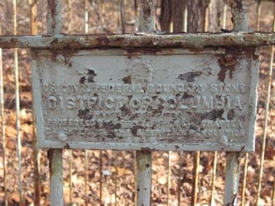
Original Federal Boundary Stone
District of Columbia
Placed 1791-1792
Protected by Dist. of Co. Chapter
Daughters of the American Revolution
1916 — — Map (db m190187) HM
Original Federal Boundary Stone
District of Columbia
Placed 1791 - 1792
Protected by John Hall Chapter
Daughters of the American Revolution
1916 — — Map (db m154768) HM
In 1790, Congress authorized the establishment of a territory 10 miles square on the Potomac River to be the Capital of the United States. It was President Washington's recommendation to use land on both sides of the river. Surveyor Andrew Ellicott, . . . — — Map (db m154770) HM
Original Federal Boundary Stone
District of Columbia
Placed • 1791 • 1792
Protected by Columbia Chapter
Daughters of the American Revolution
July 12, 1915 — — Map (db m154767) HM
Original Federal
Boundary Stone
District of Columbia
Place 1791 - 92
Protected by
Patriots' Memorial Chapter
Daughters of the
American Revolution
1965 — — Map (db m154771) HM
Original Federal Boundary Stone
District of Columbia
Placed - 1791 - 1792
Protected by the Margaret Whetten Chapter
Daughters of the American Revolution
1916 — — Map (db m154774) HM
This plaque marks the site
of the
District of Columbia
North-East
Boundary Stone No. 1
originally placed here
1791 - 1792
Presented by
The Mary Washington Chapter
Daughters of the American Revolution
and
United States . . . — — Map (db m154777) HM
Original Federal Boundary Stone
District of Columbia
Placed 1791-1792
Protected by Maryland Chapter
Daughters of the American Revolution
1916 — — Map (db m154844) HM
Placed in 1791-1792, this is one of forty Aquia Creek sandstone markers outlining the original boundaries of the Federal District as commissioned by President Washington. In 1916, The District of Columbia Daughters of the American Revolution . . . — — Map (db m154783) HM
Original Federal Boundary Stone
District of Columbia
Placed 1791-1792
Protected by Sarah Franklin Chapter
Daughters of the American Revolution
1916 — — Map (db m154788) HM
Original Federal Boundary Stone
District of Columbia
Placed 1791-1792
Protected by Marcia Burns Chapter
Daughters of the American Revolution
1916 — — Map (db m154789) HM
Original Federal Boundary Stone
District of Columbia
Placed 1791-1792
Protected by Our Flag Chapter
Daughters of the American Revolution
1916 — — Map (db m154779) HM
Original Federal Boundary Stone
District of Columbia
Placed 1791-1792
Protected by Elizabeth Jackson Chapter
Daughters of the American Revolution
1916 — — Map (db m154780) HM
Original Federal Boundary Stone
District of Columbia
Placed 1791-1792
Protected by Capt Molly Pitcher Chapter
Daughters of the American Revolution
1916 — — Map (db m154786) HM
Original Federal Boundary Stone
District of Columbia
Placed 1791-1792
Protected by Ruth Brewster Chapter
Daughters of the American Revolution
1916 — — Map (db m154790) HM
Original Federal
Boundary Stone Southeast 7
District of Columbia
Placed in 1791-1792
This plaque placed here on
the 222nd anniversary
of the founding of
Washington, DC
1790-2012 — — Map (db m154911) HM
Original Federal Boundary Stone
District of Columbia
Placed 1791-1792
Protected by Constitution Chapter
Daughters of the American Revolution
1916 — — Map (db m154781) HM
Original Federal Boundary Stone
District of Columbia
Placed 1791–1792
Protected by Livingston Manor Chapter
Daughters of the American Revolution
1916 — — Map (db m154782) HM
On March 30, 1791, a group of six men, bundled in great coats, could be seen riding on horseback over a "wilderness" on the Potomac River. The leader was George Washington, first President of the United States, who was to approve the site . . . — — Map (db m154948) HM
Original Federal Boundary Stone
District of Columbia
Placed 1791-1792
Protected by Louisa Adams Chapter
Daughters of the American Revolution
1916 — — Map (db m154927) HM
Original Federal Boundary Stone Southeast 6 District of Columbia 1791–1792 Plaque placed in 2014 by Martha Washington Chapter NSDAR Washington, DC — — Map (db m154793) HM
Did you know that you traverse the District of Columbia, Maryland, and Virginia when you cross this bridge? The brass lines in the walkway mark the boundaries. They also commemorate the cooperation required to build this bridge.
Follow the . . . — — Map (db m140997) HM
Alexandria was established by Virginia's colonial assembly in 1749, over four decades the U.S. Congress authorized creation of a national capital on the banks of the Potomac River. Once the final site for the Federal city was selected by President . . . — — Map (db m141166) HM
Wording on stone tablet to left:
Alexandria, Virginia
County seat of Fairfax 1742-1800
Organized 13th July, 1749
Incorporated by the Assembly of Virginia 1779
Ceded to the Federal Government 1789
First boundary . . . — — Map (db m167068) HM WM
In 1791, surveyors on Jones Point began to lay out the ten-mile square that would become Washington, D.C. The first marker for the survey—the south cornerstone—was set in place on this spot. Although the stone within this protective . . . — — Map (db m60162) HM
On January 22, 1791, George Washington appointed Andrew Ellicott and Benjamin Banneker to survey the boundaries of the "District of Columbia," to be the home of the Federal government of the United States. The President instructed the surveyors to . . . — — Map (db m127771) HM
After the Revolutionary War, the new nation searched for a permanent seat of government. President George Washington favored a 10-mile square territory along the Potomac River that encompassed the economically important ports of Georgetown and . . . — — Map (db m141071) HM
The open vistas, recreational fields, or fishing pier may be what drew you to Jones Point Park, but archaeological and historical evidence shows that this land has been attracting people for a multitude of reasons during the last 9,000 years. Over . . . — — Map (db m127766) HM
Original Federal Boundary Stone
District of Columbia
Placed 1791-1792
Protected by Mt. Vernon Chapter
Daughters of the American Revolution
1916 — — Map (db m154753) HM
Original Federal Boundary Stone
District of Columbia
Placed 1791 - 1792
Protected by Mt. Vernon Chapter
Daughters of the American Revolution
1916 — — Map (db m154752) HM
Original Federal
Boundary Stone Southwest 3
District of Columbia
Placed 1791-1792
This plaque placed here on the 200th anniversary of the founding of the City of Washington D.C.
Placed here and protected by Colonel John Washington . . . — — Map (db m154929) HM
The U.S. Government erected 40 sandstone markers on the boundaries of the District of Columbia in 1791 and 1792. The boundary survey was initiated by President George Washington and executed by Andrew Ellicott, who became Surveyor General of the . . . — — Map (db m154759) HM
Original Federal Boundary
Stone 1921 - 1952
District of Columbia
Placed 1791-1792
Protected by Keystone Chapter
Daughters of the American Revolution — — Map (db m154756) HM
The U.S. Government erected 40 sandstone markers on the boundaries of the District of Columbia in 1791 and 1792. The boundary survey was initiated by President George Washington and executed by Andrew Ellicott, who became Surveyor General of the . . . — — Map (db m172542) HM
Did you know? Benjamin Banneker was a…
★ Son of freed slaves from Baltimore, Maryland
★ Member of the first appointed team to survey the nation's capital, Washington, D.C.
★ Pioneered innovative agricultural . . . — — Map (db m198327) HM
Original Federal Boundary Stone
District of Columbia 1791
Protected by
Falls Church Chapter, NSDAR
Dedication 1916 Rededication 1989 — — Map (db m154760) HM
Original Federal Boundary Stone
District of Columbia
Placed 1791-1792
Protected by Continental Chapter
Daughter of the American Revolution
1918
— — Map (db m154755) HM
Original Federal Boundary Stone
District of Columbia
Placed - 1791 - 1792
Protected by Richard Arnold Chapter
Daughters of the American Revolution
1916 — — Map (db m154764) HM
In the distance is Jones Point, designated as the southern corner of the District of Columbia by President George Washington. In 1790 Congress established the nation’s capital with a ten-mile square of land ceded by Virginia and Maryland. Alexandria . . . — — Map (db m154908) HM
No. 2 Stone of N.W. Leg
Washington-Lee Society
Children of
The American Revolution
Thomas Nelson Chapter D.A.R.
October 12, 1969 — — Map (db m154765) HM
The Story of Falls Church
The community located just 10 miles from the nation's capital and today known as Falls Church boasts a history rich in culture and diversity.
The People to 1700
Native Peoples and Their Land
For . . . — — Map (db m206631) HM