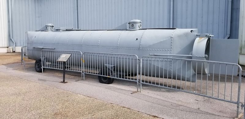
On February 17, 1864, the Confederate torpedo boat/submarine H. L. Hunley attacked and sank the Union warship U.S.S. Housatonic making it the first combat submarine to sink an enemy warship. Built in Mobile, Alabama in 1863, the . . . — — Map (db m191534) HM
Rear Admiral, Confederate States Navy,
Brigadier General, Confederate States Army,
Commander of the Alabama, the greatest
sea raider of all times.
— — — —
In this house, a gift of the
people of Mobile, . . . — — Map (db m86572) HM
Throughout the 19th and first half of the 20th century, large warehouses and commercial buildings lined Water and Commerce Streets to service the port of Mobile. One St. Louis Centre, known locally as the McGowin-Lyons Building, was the largest and . . . — — Map (db m86354) HM
When Mobile was laid out, this was the city's north-east boundary point.
Royal Street ran along a bluff overlooking the Mobile River. There were no streets between Royal and the river, only marshland. — — Map (db m86347) HM
National Cemetery
Mobile National Cemetery was established in May 1866 on 3 acres of land in Magnolia Cemetery. The City of Mobile donated the land to the federal government. The Cemetery was divided into four sections with a central . . . — — Map (db m86914) HM
Retired from the Toulminville - To - Lafayette Street run in 1904.
Restored by W.C. Martin in 1964. Building was erected in 1969, under the administration of
Commissioners: Lambert C. Mims
Arthur R. Outlaw
Joseph N. Langan
Proj. . . . — — Map (db m172190) HM
The Old Plateau Cemetery, known as the Africatown Graveyard, is the final resting place of enslaved Africans, African-Americans, and a Buffalo Soldier. The burial ground dates back to 1876, sixteen years after Africans arrived on the Clotilda . . . — — Map (db m86308) HM
One of the premier antebellum structures in the city, the house was built by Charles Richards, a riverboat captain originally from Maine. The building is considered to have Mobile's finest cast iron, featuring figures in a garden setting and . . . — — Map (db m241961) HM
The Fallen Guardians Monument
Dedicated to the personnel who lost their lives
while performing Coast Guard missions in Alabama
Eternal Father, Lord of Hosts, watch o’er the ones who guard our coasts, protect them from the raging seas and give . . . — — Map (db m136756) WM
The first submarine successfully used in warfare was completed at this site in 1863. Designed by James McClintock and Baxter Watson, and financed by Horace L. Hunley, it was built by W. A. Alexander at the Mobile machine shop of Park and Lyons. . . . — — Map (db m86244) HM
After the abolition of international slave trading in 1808, dealers transported slaves from all over the South into Mobile. On this site, Africans were sold as chattel to southern planters through public auction. Between auctions, a three-story . . . — — Map (db m86312) HM
Panel 1: "The Lookout: the Eyes of the WWII Submarine"
Panel 2: "Submarine Lookout":
Standing his watch on a perch high above the deck,
the lookout was the eyes of the submarine while
surfaced. Often while submerged he was . . . — — Map (db m74809) HM WM
The monument is dedicated to the men and women of the U.S. Coast Guard and its predecessor agencies who have served their nation from facilities in Mobile in an unbroken chain since the assignment of the revenue cutter "Alabama" to the port city in . . . — — Map (db m162425) HM WM
Named for the State of Alabama. 6th naval fighting ship to bear the name. Built by the Norfolk Navy Yard, Portsmouth, Virginia. Authorized by Congress 27 March 1934. Keel laid 1 February 1940 – Launched 16 February 1942. Sponsored by . . . — — Map (db m74366) HM WM
The vessel in front of you is a United States Navy Mark III Patrol Boat. Developed in the mid-1970's, it was designed to be a special operations boat for U.S. Navy Seals. It was also designed as a high speed weapons platform for the Naval Inshore . . . — — Map (db m191536) HM
In 1864, Wallace Turnage, a seventeen year old slave was owned by a merchant, Collier Minge, whose house stood on this site. Turnage escaped wartime Mobile by walking 25 miles down the western shore of Mobile Bay. After surviving three weeks in the . . . — — Map (db m193903) HM
By the turn of the 21st century, much of the grandeur of Mobile's longest
north-south roadway, Broad Street, had faded. The streetcar that once
connected the southern neighborhood of Oakdale to the city's northern
communities along Springhill and . . . — — Map (db m286249) HM
In 1872 the Mobile and Alabama Grand Trunk Railroad
Company laid the first tracks to the town of Mount Vernon,
with daily service to Mobile. A year later, the company
extended their rail line north to the Tombigbee River - where a
ferryboat . . . — — Map (db m149305) HM
In 1811, the Mount Vernon Cantonment, located on a hill about three miles west of the Mobile River, was laid out by Col. Thomas H. Cushing. The cantonment was on the site of a spring called Mount Vernon Springs. In 1814, the garrison at Mt. Vernon . . . — — Map (db m85911) HM
When the U.S. Army built Fort Stoddert here in 1799, one could
travel by dugout canoe and flatboat on the water or by foot and
horseback on the Indian trails that crisscrossed the landscape. There
were, however, no roads wide enough for wagons or . . . — — Map (db m149307) HM
Last known survivor of the last known slave ship to enter the United States
Circa 1859, Cudjoe Lewis, a native of the Yoruba tribe in what is now the West African country of Benin, was one of over a hundred African men and women . . . — — Map (db m112228) HM
Original Historic Site of The Old Whistler Railroad Depot.
Where Famous Train Engineer Casey Jones was Based and Married Nearby — — Map (db m300538) HM
Original church built in 1867 on land deeded by Jacob & Mary Magee on August 25, 1864. Present edifice and rectory built in 1874. Famous railroad engineer, Casey Jones, baptized here on November 11, 1886. — — Map (db m148902) HM
The historical Burnt Corn Spring is located near this point on the Old Federal Road - the spring poured into the west branch of the creek that took its name. James Cornells had a residence at the spring before 1813. In the summer of 1813, a war . . . — — Map (db m203710) HM
Burnt Corn, Monroe County's earliest settlement, became the crossroads of the Great Pensacola Trading Path and The Federal Road. Settler Jim Cornells returned from Pensacola in 1813, finding his home destroyed and his wife kidnapped by a Creek . . . — — Map (db m47687) HM
John Poebles had an established toll bridge over Little Escambia Creek in the early 1800’s. A dispute over the bridge arose between Poebles and John Hollinger. As a result Hollinger built a toll free bridge adjacent to Poebles’ toll bridge. — — Map (db m84378) HM
During the westward expansion of the United States in the early 1800’s, those whose destination was the new Mississippi Territory took a right fork off the Federal Road which led to the Alabama River ferry at Claiborne. After the land cessions of . . . — — Map (db m47638) HM
The Old Federal Road was the major highway connecting Washington,
D.C. to New Orleans from 1806 through the late 1830s. Only horse
paths existed until there was need for the US Government to
get mail, munitions and troops to New Orleans. A . . . — — Map (db m305882) HM
North of Salem Cemetery and the former church was the site of Price's Hotel, the first place to spend the night on the Federal Road after Greenville. Mr Price was also the stagecoach driver for this section between Greenville and his hotel. Mrs . . . — — Map (db m84986) HM
Bell's Landing
Bell's Landing, located 1.5 miles southwest of this site, was a busy river port for nearly a century. The Bell family, early settlers, chose the high bluff on the east side of the Alabama River because it was safe from . . . — — Map (db m313752) HM
Citation to Accompany the Award of The Air Force Cross
to
Jon D. Harston
Staff Sergeant Jon D. Harston distinguished himself by extraordinary heroism in military operations against an opposing armed force . . . — — Map (db m95475) WM
Alabama Bicentennial Park
Alabama Bicentennial Park commemorates Alabama's
200th anniversary of statehood. The park's bronze relief
sculptures present sixteen moments from Alabama history,
complemented by narratives that provide historical . . . — — Map (db m182565) HM
Twelve miles above Montgomery the Coosa and Tallapoosa rivers unite to form the Alabama which meanders over four hundred miles on its way to Mobile Bay. This river has played major role in region's history, being a thoroughfare for Native Americans, . . . — — Map (db m26591) HM
Side 1
On Dec. 1, 1955, at Alabama State College (now Alabama State University) in a basement room in Councill Hall, the Montgomery Bus Boycott was planned and publicized after the arrest that day of Rosa Parks, who refused to give up . . . — — Map (db m91279) HM
The second black Baptist Church in Montgomery. First pastor was Rev. C. O. Boothe. Present structure built 1885. Designed by Pelham J. Anderson; built by William Watkins, a member of the congregation.
Many prominent black citizens of Montgomery . . . — — Map (db m25128) HM
1540 expedition of Spanish explorer Hernando de Soto was first to penetrate Alabama interior. After advancing down Coosa Valley these adventurers camped nearby at Towasa (TO THE WEST) and then followed river on its southern course. In 1702. . . . — — Map (db m224812) HM
Also called Hostile Bluff or Thirteen Mile Bluff, this spot located in a deep bend of the Alabama River was once the key to the Southeast and a strategic point in Colonial days. The first steamboat, the Harriet, arrived at this point in 1821, and . . . — — Map (db m86120) HM
The Federal-Aid Highway Act of 1956, signed into law by President Dwight D. Eisenhower, authorized the construction of 41,000 miles of the Interstate Highway System over a ten year period - the largest public works project in American history to . . . — — Map (db m210249) HM
Role of MIA
The Montgomery Improvement Association (MIA) was founded on December 5, 1955, to implement the 382-day Montgomery Bus Boycott that jumpstarted the 20th-century Civil Rights Movement. The MIA, as its name suggests, remains . . . — — Map (db m310043) HM
Side 1
Montgomery and Electricity
Gaslights in 1854, electric lights in 1883 and the electric trolley in 1886 made Montgomery a state leader in applying modern technology for lighting and motive power. Steam was used first for . . . — — Map (db m71367) HM
On multiple occasions in 1955, black women were arrested for challenging Montgomery's law requiring racial segregation on buses. The arrest of Rosa Parks sparked a mass protest that launched the modern civil rights movement and brought to prominence . . . — — Map (db m118040) HM
The six streets which cross Dexter Avenue between Court Square and the State Capitol are named for Oliver Hazard Perry, James Lawrence, Thomas Macdonough, Issac Hull, Stephen Decatur and William Bainbridge, all naval officers of the War of 1812. . . . — — Map (db m99545) HM
Pickett Springs
Railroad building and amusement park development flourished in the post-bellum South. In 1880s, Western Railroad of Alabama opened Pickett Springs on site of William Harris’s plantation, “Forest Farm;” Harris’s daughter, Sarah, . . . — — Map (db m38900) HM
Montgomery native Ray W. Scott Jr. launched the Bass Anglers Sportsman Society (B.A.S.S.) in 1967 from a small office upstairs at 513 Madison Avenue. From this beginning, B.A.S.S. became the largest sportfishing organization in the world. Scott . . . — — Map (db m98551) HM
Side A A Lady of Courage
Born in Tuskegee, AL on February 4, 1913, to James McCauley, a carpenter, and Leona Edwards, a teacher. Moved with mother and brother to Pine Level, AL after parents' separation. Enrolled in Mrs. White's School . . . — — Map (db m36503) HM
On December 1, 1955, Rosa Louis McCauley Parks was arrested on this site for refusing the order of city bus driver J. F. Blake to vacate her seat under the segregation laws of the Jim Crow era. She was taken to police headquarters at City Hall . . . — — Map (db m91286) HM
Only surviving residence of former Mayor E.B. Joseph. The Italianate cottage was built c. 1855 by Pickett Chauncey Smith, a merchant in antebellum Montgomery, and father-in-law of E.B. Joseph, who occupied the house from 1880 to 1885. Joseph served . . . — — Map (db m86426) HM
This 2.8-mile road connecting U.S. highways 331 and 31 first appeared on Montgomery County road maps in 1928. Land for the road was deeded to Montgomery County in September 1926 by local landowners from the Teague, Bellingrath and Matthews families. . . . — — Map (db m70932) HM
This 2.8-mile road connecting U.S. highways 331 and 31 first appeared on Montgomery County road maps in 1928. Land for the road was deeded to Montgomery County in September 1926 by local landowners from the Teague, Bellingrath and Matthews families. . . . — — Map (db m99235) HM
Side 1
The Domestic Slave Trade
Beginning in the seventeenth century, millions of African people were kidnapped, sold into slavery, and shipped to the Americas as part of the Transatlantic Slave Trade. In 1808, the United States . . . — — Map (db m86427) HM
The Lightning RouteIn 1886, Montgomery became the first city in the Western Hemisphere to convert an entire street railway system to electricity. The Capital City Street Railway Co. initiated electric trolley service on one mile of the street . . . — — Map (db m86468) HM
Few sheds of this type, once so much a part of the urban scene, remain. Designed by railroad engineers, it illustrates the beginnings of that technology which made possible the skyscrapers and bridges
of today. — — Map (db m94031) HM
In October. 1821, steamboat Harriett arrived at city wharf, introducing a new method of transporting goods as Montgomery became increasingly important market center for region. Until early years of 20th century Steamboats continued to ply river. In . . . — — Map (db m224806) HM
The ten bronze roundels displayed on this wall are a tribute to the
"foot soldiers" who toiled for 382 days during the Montgomery Bus
Boycott of 1955 and 1956. The roundels depict individuals who
were involved in, and events that occurred . . . — — Map (db m91276) HM
Union Station & Riverfront Park
Transportation center of Montgomery located in this area for many years. First steamboat, the "Harriet," landed nearby 1821. City wharf constructed at landing place 1823. First railroad, Montgomery & West . . . — — Map (db m86470) HM
Charlestown was developed by Charles Van Depoele, a pioneer in electric railway technology and inventor of the electric trolley pole. The first citywide electric streetcar system, the Capital City Street Railway or the Lightening Route ran parallel . . . — — Map (db m250889) HM
Side 1
Remount Depot
During World War I, in the summer of 1917 the U.S. Army opened a remount depot here to buy horses and mules for Camp Sheridan's 27,000-man 37th Division from Ohio. Despite the introduction of motor transport . . . — — Map (db m71340) HM
In this house, built in 1948, Frank and Alberta Smith raised their six children.
Through their activism and participation in two landmark suits, members of the Smith family played critical roles in the Civil Rights Movement. The family attended St. . . . — — Map (db m223847) HM
Side 1
The Federal Road
The 1803 Louisiana Purchase acquired 828,000 sq. mi. for the U.S., doubling its size. The Federal Road was built to provide a shorter route from Washington to New Orleans and the new territory. The Treaty . . . — — Map (db m71535) HM
Of the various detachments that removed the Cherokee People from their home lands in the southeastern United States, three of them landed in Decatur at what became Rhodes Ferry Park. Due to the difficulty of navigating the Muscle Shoals portion of . . . — — Map (db m140846) HM
For whom this lake in Tennessee River is named lived 1836-1906. His home 16 miles west. Lt. Gen. in Confederate Army 1864-5. Maj. Gen. U. S. Army 1898. Named by Alabama to Hall of Fame, Washington, 1922. — — Map (db m27760) HM
Public Buildings
1. Public City Hall
2. Decatur Police Station
3. Decatur/Morgan Co. Chamber of Comm.
4. Decatur Public Library
5. Federal Bldg./Post Office
6. Morgan County Archives
7. Morgan County Courthouse
8. Morgan . . . — — Map (db m103228) HM
Ingalls Iron Works was established in 1910, by Robert Ingalls, in Titusville Alabama. It became the largest steel company in the region. Looking for new opportunities for the steel his company fabricated, Ingalls opened Ingalls Shipyard in 1937 to . . . — — Map (db m86507)
The Old Decatur Historic District dates Back to the town's settlement in 1817; at that time it was called Rhodes Ferry Landing after Dr. Henry W. Rhodes, an early landowner who operated a ferry across the Tennessee River. In 1820, President . . . — — Map (db m103229) HM
On this river in front of you, 2,300 Cherokee people arrived in waves, forced from their Tennessee Valley homeland in 1837 to 1838. The steamer Knoxville towed flat boats loaded with Cherokee families. Heavy rains soaked their clothes. Cold . . . — — Map (db m140855) HM
In 1860, the Memphis and Charleston Railroad was the only east-west route through the United States south of the Mason-Dixon Line. Maintaining control of this rail line was essential to Confederate strategy. Union Brigadier General Ormsby Mitchell . . . — — Map (db m28262) HM
This is a site of painful memory, a place of upheaval. Decatur was just one stop on a deadly journey over 1,000 miles — the forced removal of the Cherokee people from the Tennessee Valley.
Along the edge of the Tennessee River, this town bore . . . — — Map (db m189597) HM
Old Bethel Road first came into use during the mid-nineteenth century. It ran adjacent to the property deeded to George Hartselle by President Polk in 1845 and President Buchanan in 1858. The road later connected with Fletcher Ferry Road and Georgia . . . — — Map (db m217103) HM
Known as the "Crossroads of North Alabama,” the Town of Priceville incorporated in April 1975, though its earliest settlers migrated to the foot of Priceville Mountain just after the War of 1812. The community was rich farmland once owned by the . . . — — Map (db m191691) HM
The Carrollton Short Line Railroad, authorized by the legislature in 1897, connected the Mobile & Ohio Railroad at Reform with the Pickens County seat. John Taylor Cochrane of Tuscaloosa, working with Carrollton citizens, completed that line in . . . — — Map (db m92644) HM
The Mobile & Ohio Railroad Company in 1897 announced plans to build a line from Artesia, Mississippi through Pickens County to Tuscaloosa and on the Montgomery. Leading citizens in Carrollton sought to persuade the company to bring the line through . . . — — Map (db m178594) HM
This area's first settlers arrived in the 1830s and established the Crossroads community at the intersection of the Columbus-Tuscaloosa and Vienna-Fayette stagecoach roads, one mile northeast of Gordo's present location on Highway 82. The name . . . — — Map (db m152577) HM
What is a Snagboat?
Snagboats remove snags – underwater trees, stumps, or branches – that created obstructions to river navigation. A large grapple or clamshell on the snagboat’s beam pulled these obstacles from the river. Equipped with a scoop . . . — — Map (db m236057) HM
In June 1985, the U.S. Army Corps of Engineers, Mobile District, opened the Tennessee - Tombigbee Waterway. This carefully planned engineering effort created a year-round commercial navigation route 234 miles long. Stretching from the rugged north . . . — — Map (db m179089) HM
The U.S. Snagboat Montgomery was designated a National Historic Landmark in June of 1989. Serving as one of the South’s last steam~powered sternwheelers, the Montgomery was used by the U.S. Army Corps of Engineers to maintain seven navigable rivers. . . . — — Map (db m179079) HM
In the early 1800s, south Alabama was still inhabited by many groups of Native Americans: Creek, Chickasaw, and Choctaw among others. They traveled, hunted, traded, and made war on the many ancient trails here. European settlers improved these roads . . . — — Map (db m95359) HM
Built by U.S. Army, 1824,
from Ft. Barrancas, at Pensacola
to Ft. Bainbridge, S.E. of Tuskegee.
Here it joined Federal Road leading to
Ft. Mitchell in Russell County.
Road followed Indian trade trail
Became main road . . . — — Map (db m76745) HM
Fort Mitchell served as a primary point of concentration for creeks being sent westward to Indian Territory before, during, and after the Second Creek War (1836-1837). By the terms of the 1832 Treaty of Washington, Creek heads of household and . . . — — Map (db m101840) HM
East of here, on the Chattahoochee River, was the "fort among the Apalachicolas," most northern of the Spanish settlements in eastern North America. A palisaded "strong house" built by Captain Enrique Primo de Rivera to check activities of English . . . — — Map (db m101252) HM
To the native people of the Chattahoochee River Valley, the Creek or Muskogulgi Indians, the shoals of the river were a source of recreation and food. In the spring, the women and children of Coweta Town came here to fish, using dip nets, spears, . . . — — Map (db m69045) HM
The town of Coweta was actually two separate Native American settlements and dozens of affiliated outlying communities occupied at different times in what is now northeastern Russell County. "Coweta Tallahassee" (old Coweta), regarded by most . . . — — Map (db m101328) HM
The Creek Indians believed this section of the river was inhabited by a giant Tie-Snake, a mythical monster that snared the unwary and dragged them down into the watery underworld. The Tie-Snake was but one of many strange creatures and natural . . . — — Map (db m69067) HM
Oldest route from Atlantic to Southwest. In 1805 it became Federal Road, over which pioneers traveled from Milledgeville to St. Stephens. Oglethorpe, Lafayette, Burr and others used this trail. — — Map (db m165635) HM
The Old Federal Road that opened the southeastern United States to
settlers once crossed at this location. In 1805, the United States Congress
granted funds to build a post road from Georgia to New Orleans to
cross the sparsely settled wilderness . . . — — Map (db m237220) HM
Side 1
During the final years of the Civil War, Montgomery merchants, Hannon, Offutt & Company, built a rolling mill here along the banks of Buck Creek. Called the Central Iron Works, the plant’s construction was superintended by Thomas . . . — — Map (db m76241) HM
The South and North Alabama Railroad Company constructed the Helena Freight House & Depot about 1872 while repairing damage inflicted by Union raiders in 1865. The original location of the structure was just north of the present railroad . . . — — Map (db m76262) HM
At a crossroads, one mile south of Helena, a post office called Cove was established in 1849 and renamed Hillsboro in 1857. During the Civil War the South & North Railroad (the Louisville & Nashville Railroad) was constructed to just north of . . . — — Map (db m76243) HM
Constructed around 1890 to transport large deposits of minerals in the region. Iron ore, marble, limestone, and coal, the L&N Railroad also ran passenger trains daily. The L&N depot was built in 1909 directly behind where you are standing. It was . . . — — Map (db m79403) HM
Founder of Buffalo Rock Company (1901) in Birmingham and creator of Buffalo Rock Ginger Ale, a medicinal tonic first used in the Civil War. Lee's vision and influential support inspired the construction of this road across Double Oak Mountain . . . — — Map (db m52693) HM
Side 1
Wilton, a once prominent railroad town now sits nestled quietly in the southwest corner of Shelby County. Founding members were as follows: L. McMillen, L.W. Irwin, O. H. Bice, John Westley Little, Sam Vest, L. Cochran, and O. L. . . . — — Map (db m76246) HM
Near this site, and founded by entrepreneur Lafayette Cooke, for whom the community of Cook Springs was named, the hotel resort, operated from 1884 to 1954, was a grand example of mineral-springs resorts developed around the nation during that era. . . . — — Map (db m217684) HM